Atalaya Trail Photos


More like Atalaya Trail
Recommended Reviews - Atalaya Trail
Start your review...

Reviews With Photos

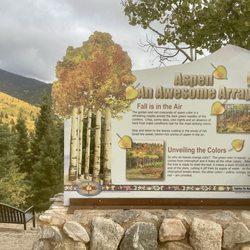
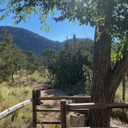
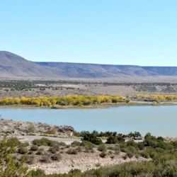
My father and I stumbled upon this gorgeous trail the last time we visited Santa Fe, my second favorite city in America (San Antonio being the first, of course). I can't quite recall its location (I'm directionally challenged and require a GPS to locate my underwear...even when I'm wearing underwear), but I know it's on the outskirts of town near a residential neighborhood. If you're interested, simply queue up Google Maps and enter "Atalaya Trail." As we pulled into the parking lot, we were perturbed to see a bunch of signs reading, "High vehicle break-in area! Park at your own risk!," but all of our valuables (i.e., the dozens of DEVO CDs to which I subject my father) were back at the hotel, so we took a calculated risk and embarked on the hike. Like practically every square inch of Santa Fe, the trail is beautiful, with dozens of scenic overlooks and dense foliage (pictures attached). We spotted several deer and lots of cute little black squirrels, one of whom seemed particularly smitten with me. Perhaps he was my spirit animal, or maybe I reeked of cashew butter. I'd hoped to capture a few pictures of the wildlife, but the critters proved uncooperative. Several reviewers have noted that sections of the trail are very steep, but my father and I had little difficulty ascending the mountain. I should note, however, that the air in Santa Fe is noticeably thinner than the air in San Antonio, so be prepared to give your lungs a workout if you're unaccustomed to higher altitudes. I'm in excellent shape, but even I felt out of breath at times. A couple of local kids were practically running up the mountain (probably showing off), but I didn't let them spoil my fun. I just moved to the side, bid them "good morning," and hoped to see them get eviscerated by a mountain lion. Atalaya Trail is just one of several breathtaking (literally and figuratively) hiking areas in Santa Fe, but it's arguably our favorite so far. It's a perfect excuse to enjoy the outdoors and work up an appetite for a five-star dining experience at Geronimo or The Compound (review coming soon).

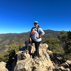
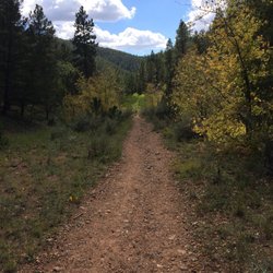
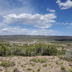
What a trail! I am an avid hiker and had done some research on the Santa Fe area looking for one of the most challenging hikes in the area, and Atalaya certainly fit the bill. Clocking in at just under 7 miles roundtrip and approx. 2000 ft of elevation gain, this one is not for beginners. The initial mile or so is fairly flat as you weave your way through a dirt path by St. John's College and some homes. Once you cross the street and go in between the fence though, that's the part where you know it's on for the incline. As you make your way up the mountain, you will see a fork for a steeper route vs. an easier route. I've heard the easier route is longer so if you have the stamina I'd go with the former (and it's not THAT bad compared to other hikes I've done in my state of AZ). Getting to the top after numerous switchbacks and gazing out onto Santa Fe at 9,120 feet truly feels like an accomplishment, and the view a great reward. There was a forest fire whose smoke blocked a lot of the surrounding mountains from coming into view but the scenery of Santa Fe was still breathtaking. The way back down is obviously quicker but watch your knees as it can get pretty steep! Please pack in what you pack out to keep it clean for everyone else to enjoy, and most of all have a great time!

Excellent views at the top, you just have to make it. :) It gets STEEP. Hiking poles will go along way. Also make sure to have a snack and water, because you will exert yourself. If you only do the first part and stop at the road above, it can be a nice more leisurely hike. It goes up, but not quite so dramatically. Many people out with dogs on the bottom half, as well as quite a few mountain bikers. The trail can be kind of tight, so keep your eyes and ears out.

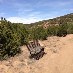
Atalaya Trail is a very serviceable and enjoyable trail. It's just the right length for an afternoon (or morning) hike, and it offers just enough elevation gain that you won't be bored by the level of endeavor required. That said, apart from the views you'll be rewarded with when you're here, there's not a whole lot else of interest to see during your visit. Tip: This is a popular destination for both hikers and cyclists; both of the aforementioned need to keep their eyes peeled for their opposite numbers; hikers especially need to exercise caution to avoid being hit by oblivious cyclists. I've been here several times recently, and very much enjoy myself each time. I've found that the views (especially from the top) are very rewarding. Because it's very easily accessible from all over the area, the trail can sometimes get very crowded; it's best to visit either in the early morning or at off-peak hours to optimize avoid the crowds. The trail winds through the Cruz Blanca neighborhood before rapidly ascending up the side of Atalaya Mountain; it eventually reaches a height of just over nine thousand feet. While the final stretch is quite gravelly and steep, the views from the top are totally worth it! read more


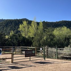
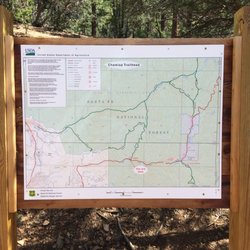
Part of the Dale Ball trail system, that include the Dorothy Stewart and Wilderness Trailheads. The parking lot near after entry for St John's college is the largest and furthest away. Drive up Camino Cruz Blanca and save yourself the 1.5 walk along the road past $1MM homes to these other trailheads. As with everything Dale Ball creates, this is a superbly marked trail system that allows the hiker to plan and tailor their experience. I made a bee-line to the summit of Mt. Picacho. Beautiful vista, but I'll need to return for a sunset and very carefully make my way down the steeper parts of a darkening trail. read more


3 years ago
My father and I stumbled upon this gorgeous trail the last time we visited Santa Fe, my second favorite city in America (San Antonio being the first, of course). I can't quite recall its location (I'm directionally challenged and require a GPS to locate my underwear...even when I'm wearing underwear), but I know it's on the outskirts of town near a residential neighborhood. If you're interested, simply queue up Google Maps and enter "Atalaya Trail." As we pulled into the parking lot, we were perturbed to see a bunch of signs reading, "High vehicle break-in area! Park at your own risk!," but all of our valuables (i.e., the dozens of DEVO CDs to which I subject my father) were back at the hotel, so we took a calculated risk and embarked on the hike. Like practically every square inch of Santa Fe, the trail is beautiful, with dozens of scenic overlooks and dense foliage (pictures attached). We spotted several deer and lots of cute little black squirrels, one of whom seemed particularly smitten with me. Perhaps he was my spirit animal, or maybe I reeked of cashew butter. I'd hoped to capture a few pictures of the wildlife, but the critters proved uncooperative. Several reviewers have noted that sections of the trail are very steep, but my father and I had little difficulty ascending the mountain. I should note, however, that the air in Santa Fe is noticeably thinner than the air in San Antonio, so be prepared to give your lungs a workout if you're unaccustomed to higher altitudes. I'm in excellent shape, but even I felt out of breath at times. A couple of local kids were practically running up the mountain (probably showing off), but I didn't let them spoil my fun. I just moved to the side, bid them "good morning," and hoped to see them get eviscerated by a mountain lion. Atalaya Trail is just one of several breathtaking (literally and figuratively) hiking areas in Santa Fe, but it's arguably our favorite so far. It's a perfect excuse to enjoy the outdoors and work up an appetite for a five-star dining experience at Geronimo or The Compound (review coming soon). read more


What a trail! I am an avid hiker and had done some research on the Santa Fe area looking for one of the most challenging hikes in the area, and Atalaya certainly fit the bill. Clocking in at just under 7 miles roundtrip and approx. 2000 ft of elevation gain, this one is not for beginners. The initial mile or so is fairly flat as you weave your way through a dirt path by St. John's College and some homes. Once you cross the street and go in between the fence though, that's the part where you know it's on for the incline. As you make your way up the mountain, you will see a fork for a steeper route vs. an easier route. I've heard the easier route is longer so if you have the stamina I'd go with the former (and it's not THAT bad compared to other hikes I've done in my state of AZ). Getting to the top after numerous switchbacks and gazing out onto Santa Fe at 9,120 feet truly feels like an accomplishment, and the view a great reward. There was a forest fire whose smoke blocked a lot of the surrounding mountains from coming into view but the scenery of Santa Fe was still breathtaking. The way back down is obviously quicker but watch your knees as it can get pretty steep! Please pack in what you pack out to keep it clean for everyone else to enjoy, and most of all have a great time! read more


11 years ago
Excellent views at the top, you just have to make it. :) It gets STEEP. Hiking poles will go along way. Also make sure to have a snack and water, because you will exert yourself. If you only do the first part and stop at the road above, it can be a nice more leisurely hike. It goes up, but not quite so dramatically. Many people out with dogs on the bottom half, as well as quite a few mountain bikers. The trail can be kind of tight, so keep your eyes and ears out. read more


9 years ago
10 years ago
I had a wonderful hike here. It's a beautiful trail and just the perfect distance for a few hours hike. Hidden treasure in this city. Will be back soon. read more


11 years ago
10 years ago
10 years ago
11 years ago
9 years ago
10 years ago
More info about Atalaya Trail
Santa Fe, NM 87505
Directions
Hours
Outdoor Amenities
Ask the Community - Atalaya Trail
Review Highlights - Atalaya Trail


Atalaya Trail - hiking - Updated June 2026
Best of Santa Fe
People found Atalaya Trail by searching for…
Scenic View in Santa Fe, New Mexico
Sunset View in Santa Fe, New Mexico
Things to Do in Santa Fe, New Mexico
Hiking Trails in Santa Fe, New Mexico
Walking Trails in Santa Fe, New Mexico
Easy Hikes in Santa Fe, New Mexico
Off Road Trails in Santa Fe, New Mexico
Photo Spots in Santa Fe, New Mexico
Running Trails in Santa Fe, New Mexico
Watch Sunset in Santa Fe, New Mexico
Parks for Kids in Santa Fe, New Mexico
Scenic Overlook in Santa Fe, New Mexico
Hiking Groups in Santa Fe, New Mexico
Places to Take Pictures in Santa Fe, New Mexico
Night Hike in Santa Fe, New Mexico
Beautiful Views in Santa Fe, New Mexico
Secret Spots in Santa Fe, New Mexico
Trails in Santa Fe, New Mexico
Hiking With Kids in Santa Fe, New Mexico
Scenic Drive in Santa Fe, New Mexico
Star Gazing in Santa Fe, New Mexico
Trending Searches in Santa Fe, NM
Fishing Spots near Atalaya Trail
Fruit Picking near Atalaya Trail
Kayak Rental near Atalaya Trail
Lakes & Ponds near Atalaya Trail
Off Road Trails near Atalaya Trail
Outdoor Activities near Atalaya Trail
Places To Swim near Atalaya Trail
Pool Supplies near Atalaya Trail
Public Shower near Atalaya Trail
Public Swimming Pools near Atalaya Trail
River Swimming near Atalaya Trail
River Tubing near Atalaya Trail
Running Trails near Atalaya Trail
Scenic Night View near Atalaya Trail
Scenic Overlook near Atalaya Trail
Strawberry Picking near Atalaya Trail
Sunrise View near Atalaya Trail
Swimming Holes near Atalaya Trail
Swimming Lakes near Atalaya Trail
U Pick Farms near Atalaya Trail
Watch Sunset near Atalaya Trail
Browse Articles
Browse Brands
Related Searches in Santa Fe, NM
Best Fishing Locations and Guides in Santa Fe, New Mexico
Best Fun Things to Do in Santa Fe, New Mexico
Best Places for Horseback Riding in Santa Fe, New Mexico
Best Sledding Spots and Fun in Santa Fe, New Mexico
Best Spots for Star Gazing in Santa Fe, New Mexico
Check Out Off Road Trails in Santa Fe, New Mexico
Discover Dog Friendly Trails to Explore in Santa Fe, New Mexico
Discover a Hiking Trail in Santa Fe, New Mexico
Discover the Best Night Hike Trails in Santa Fe, New Mexico
Discover the Best Running Track in Santa Fe, New Mexico
Dog-Friendly Hikes With Dogs in Santa Fe, New Mexico
Enjoy Camping Adventures Around Santa Fe, New Mexico
Enjoy Exciting Mountain Biking Adventures in Santa Fe, New Mexico
Enjoy Tent Camping Spots Around Santa Fe, New Mexico
Enjoy Water Activities and Fun in Santa Fe, New Mexico
Enjoy the Best Family Activities in Santa Fe, New Mexico
Enjoy the Best Picnic Spots and Ideas in Santa Fe, New Mexico
Enjoy the Best Walking Trails in Santa Fe, New Mexico
Experience Stunning Sunset Views in Santa Fe, New Mexico
Experience Thrilling White Water Rafting in Santa Fe, New Mexico
Explore Beautiful Parks and Green Spaces in Santa Fe, New Mexico
Explore Easy Hikes Perfect for All in Santa Fe, New Mexico
Explore Fun Activities to Do in Santa Fe, New Mexico
Explore Nature Spots Around Santa Fe, New Mexico
Explore Popular Campgrounds Near Santa Fe, New Mexico
Explore Scenic Lakes to Visit in Santa Fe, New Mexico
Explore Secret Spots Worth Visiting in Santa Fe, New Mexico
Explore Top Dog Parks in Santa Fe, New Mexico Near You
Explore the Best Trail Options in Santa Fe, New Mexico
Family Friendly Hiking With Kids in Santa Fe, New Mexico
Find Beautiful Views in Santa Fe, New Mexico
Find the Best Parks for Picnics in Santa Fe, New Mexico
Find the Best Playgrounds to Visit in Santa Fe, New Mexico
Find the Best Scenic View Locations in Santa Fe, New Mexico
Hiking Trails With Waterfalls in Santa Fe, New Mexico
Off Leash Dog Hiking Trails in Santa Fe, New Mexico
Perfect Spots to Watch Sunset in Santa Fe, New Mexico
Popular Fishing Spots to Explore in Santa Fe, New Mexico
Popular Outdoor Activities to Try in Santa Fe, New Mexico
Popular Things to Do in Santa Fe, New Mexico
Popular Things to See in Santa Fe, New Mexico
Safe River Swimming Areas in Santa Fe, New Mexico
Safe and Fun Parks for Kids in Santa Fe, New Mexico
Top Climbing Spots and Gyms in Santa Fe, New Mexico
Top Paddleboarding Activities in Santa Fe, New Mexico
Top Running Trails to Explore in Santa Fe, New Mexico
Top Swimming Lakes to Enjoy in Santa Fe, New Mexico
Top Swimming Spots and Pools in Santa Fe, New Mexico