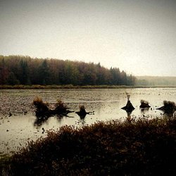
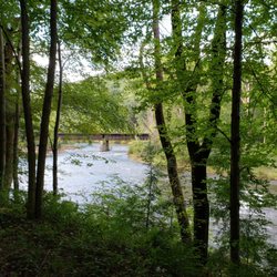
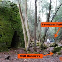
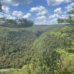
Bilgers Rocks Photos


You might also consider
More like Bilgers Rocks
Recommended Reviews - Bilgers Rocks
Start your review...

3 years ago
Nice area to visit. Great for kids. Lots of huge rocks to climb around on. Plenty of parking. Concession stand available. Primitive bathrooms. It's free to visit, donations boxes posted at trailhead. read more
Beautiful fall day in Pennsylvania. Cross country drive from Pittsburgh to Clearfield. We see a sign for Bilgers Rocks and decide to check it out. There were three separate photo shoots happening, including a bride - complete with wedding dress. The locals know what they've got here regarding backdrop opportunities, for sure. The area is very beautiful, and the rocks are house- sized. The area has a large parking area, trail maps, pavilions, camping and a forest snack bar. Definitely worth a day trip for any nature lovers. Maybe worth a weekend for you wilderness lovers! read more


8 years ago
More info about Bilgers Rocks
1921 Bilgers Rocks Rd
Grampian, PA 16838
Directions
(814) 236-3597
Call Now
Hours
Outdoor Amenities
Other Amenities


Bilgers Rocks - hiking - Updated July 2026
Best of Grampian
People found Bilgers Rocks by searching for…
Places to Take Pictures in Grampian, PA
Beautiful Views in Grampian, PA
River Swimming in Grampian, PA
Camping & Campsites in Grampian, PA
Parks for Kids in Grampian, PA
Fun Things to Do With Kids in Grampian, PA
Camping Cabins in Grampian, PA
Natural Hot Springs in Grampian, PA
Walking Trails in Grampian, PA
Trending Searches in Grampian, PA
Browse Articles
Browse Nearby
BEST of Grampian, Pennsylvania Things to Do near Bilgers Rocks
BEST of Grampian, Pennsylvania Parks near Bilgers Rocks
BEST of Grampian, Pennsylvania Breakfast near Bilgers Rocks
BEST of Grampian, Pennsylvania Fishing near Bilgers Rocks
BEST of Grampian, Pennsylvania Restaurants near Bilgers Rocks
BEST of Grampian, Pennsylvania Pizza near Bilgers Rocks
BEST of Grampian, Pennsylvania Campgrounds near Bilgers Rocks
Browse Brands
Related Cost Guides
Related Searches in Grampian, PA
Best Fishing Locations and Guides in Grampian, Pennsylvania
Best Nature Trails for Hiking in Grampian, Pennsylvania
Best Spots for Star Gazing in Grampian, Pennsylvania
Best Water Parks for Kids in Grampian, Pennsylvania
Check Out Great Playgrounds in Grampian, Pennsylvania
Check Out Off Road Trails in Grampian, Pennsylvania
Discover Baseball Fields Around Grampian, Pennsylvania
Discover Dog Friendly Trails to Explore in Grampian, Pennsylvania
Discover Free Campgrounds in Grampian, Pennsylvania Area
Discover Lakes & Ponds to Explore in Grampian, Pennsylvania
Discover Popular Bike Trails in Grampian, Pennsylvania
Discover Popular Photo Spots in Grampian, Pennsylvania
Discover Scenic Beach Camping Sites in Grampian, Pennsylvania
Discover Scenic Mountain Bike Trails Near Grampian, Pennsylvania
Discover Top Nature Parks to Visit in Grampian, Pennsylvania
Discover a Hiking Trail in Grampian, Pennsylvania
Discover the Best Fishing Lake in Grampian, Pennsylvania
Discover the Best Night Hike Trails in Grampian, Pennsylvania
Discover the Best Running Track in Grampian, Pennsylvania
Dog-Friendly Hikes With Dogs in Grampian, Pennsylvania
Enjoy Camping Adventures Around Grampian, Pennsylvania
Enjoy Hiking Adventures in Grampian, Pennsylvania
Enjoy the Best Night View Spots in Grampian, Pennsylvania
Enjoy the Best Picnic Spots and Ideas in Grampian, Pennsylvania
Enjoy the Best Walking Trails in Grampian, Pennsylvania
Experience Stunning Sunset Views in Grampian, Pennsylvania
Explore Beautiful Parks and Green Spaces in Grampian, Pennsylvania
Explore Easy Hikes Perfect for All in Grampian, Pennsylvania
Explore Free Picnic Areas Around Grampian, Pennsylvania
Explore Popular Campgrounds Near Grampian, Pennsylvania
Explore Popular Picnic Areas Around Grampian, Pennsylvania
Explore Popular RV Parks Around Grampian, Pennsylvania
Explore Popular Scenic Views Near Grampian, Pennsylvania
Explore Popular View Points Around Grampian, Pennsylvania
Explore Top Dog Parks in Grampian, Pennsylvania Near You
Explore Volleyball Courts Available in Grampian, Pennsylvania
Explore the Best Swimming Holes Around Grampian, Pennsylvania
Explore the Best Trail Options in Grampian, Pennsylvania
Family Friendly Hiking With Kids in Grampian, Pennsylvania
Find Beautiful Views in Grampian, Pennsylvania
Find Cozy Camping Cabins in Grampian, Pennsylvania
Find Fun Kids Activities Outdoor in Grampian, Pennsylvania
Find Parks and Recreation Activities in Grampian, Pennsylvania
Find Picnic Tables for Outdoor Fun in Grampian, Pennsylvania
Find Top Dog Friendly Parks to Visit in Grampian, Pennsylvania
Find Top Dog Swimming Spots in Grampian, Pennsylvania
Find Top-Rated Waterfalls in Grampian, Pennsylvania Now
Find a Public Running Track in Grampian, Pennsylvania
People who viewed Bilgers Rocks also viewed
Parker Dam State Park
11 reviews
SB Elliott State Park
4 reviews
Woodland Campground
12 reviews
Big Country Campgrounds
6 reviews
Mahoning Shadow Trail
1 review
Benezette Township of
2 reviews
David S Ammerman Trail
1 review
Journey on the Fly Guide Service
1 review
The We Are Inn
32 reviews
Bobette Motel & Diner
15 reviews
$