49th Ave Trailhead Photos


You might also consider
More like 49th Ave Trailhead
Recommended Reviews - 49th Ave Trailhead
Start your review...

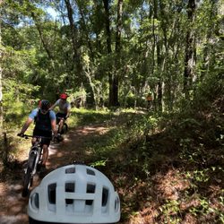
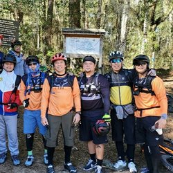
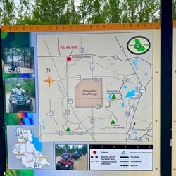
49th Ave Trailhead is a system of trails that connects 13 miles from the main Santos Trails. It is a well kept trail in my opinion. The trail gives you The Good, The Bad and The Ugly when it comes to trail riding. The trail features 3 trails: Nayls South (The Good), is mainly a green rated (easy), single track trail. It's very flowy, making it ideal trail for cross country riders. Then you eventually hit a blue rated (more difficult) trail Nayls North (The Bad), which is a bit more challenging compared to its South counterpart because of the changes of elevation and many rooty areas you encounter along the way, making for a bumpy ride. Then there is The Ugly, which is Ern N Burn, a scenic blue rated trail that eventually marries itself to the Troll Bridge, a short, technical, yet fun trail. And it feels like a scavenger hunt when it comes to finding that infamous Troll and so satisfying once you do. Additionally, you will cross into the Cross Florida Greenway Trail, a paved path that crosses path in between all the trails. You will often find many road bikers using this system. It also makes for a great bailout option if you want to get away from riding on the trails. All in all, I really enjoyed this trail and cannot wait to come back. read more


 - Mountain Biking Near Me - Ocala, Florida")


7 years ago
More info about 49th Ave Trailhead
12555 SW 49th Ave
Ocala, FL 34473
Directions
Hours
Outdoor Amenities


49th Ave Trailhead - mountainbiking - Updated June 2026
Best of Ocala
People found 49th Ave Trailhead by searching for…
Things to Do With Kids in Ocala, Florida
Places to Take Pictures in Ocala, Florida
Off Road Trails in Ocala, Florida
Walking Trails in Ocala, Florida
Picnic Areas in Ocala, Florida
Scenic Restaurants in Ocala, Florida
Picnic Spots in Ocala, Florida
Parks for Kids in Ocala, Florida
Picnic Tables in Ocala, Florida
Bicycle Shop in Ocala, Florida
Electric Bike Shop in Ocala, Florida
Playgrounds for Kids in Ocala, Florida
Scenic Places to Walk in Ocala, Florida
Free Things to Do in Ocala, Florida
Scenic Drive in Ocala, Florida
Trending Searches in Ocala, FL
Black Owned Nail Salons near 49th Ave Trailhead
Boat Rental near 49th Ave Trailhead
Day Trips near 49th Ave Trailhead
Dog Friendly Trails near 49th Ave Trailhead
Fireworks near 49th Ave Trailhead
Fishing Spots near 49th Ave Trailhead
Jet Ski Rental near 49th Ave Trailhead
Kayak Rental near 49th Ave Trailhead
Mountain Biking near 49th Ave Trailhead
Outdoor Activities near 49th Ave Trailhead
Picnic Areas near 49th Ave Trailhead
Public Pools near 49th Ave Trailhead
River Swimming near 49th Ave Trailhead
Scenic Night View near 49th Ave Trailhead
Soccer Store near 49th Ave Trailhead
Splash Pad near 49th Ave Trailhead
Star Gazing near 49th Ave Trailhead
Strawberry Picking near 49th Ave Trailhead
Swimming Holes near 49th Ave Trailhead
Swimming Lakes near 49th Ave Trailhead
Browse Articles
Browse Nearby
BEST of Ocala, Florida Coffee near 49th Ave Trailhead
BEST of Ocala, Florida Parks near 49th Ave Trailhead
BEST of Ocala, Florida Things to Do near 49th Ave Trailhead
BEST of Ocala, Florida Restaurants near 49th Ave Trailhead
BEST of Ocala, Florida Breakfast near 49th Ave Trailhead
Browse Brands
Related Searches in Ocala, FL
Affordable Bike Repair Services in Ocala, Florida
Affordable Bike Tune Up Services in Ocala, Florida
Affordable Kayak Rental Services in Ocala, Florida
Affordable Tandem Bike Rental in Ocala, Florida
Best Dog Hiking Trails Around Ocala, Florida
Best Electric Bike Rental Services in Ocala, Florida
Best Fishing Locations and Guides in Ocala, Florida
Best Places for Horseback Riding in Ocala, Florida
Best Used Bikes for Sale Near Ocala, Florida
Check Out Off Road Trails in Ocala, Florida
Discover Popular Bike Tours in Ocala, Florida
Discover Scenic Mountain Bike Trails Near Ocala, Florida
Discover Top State Parks to Visit in Ocala, Florida
Discover the Best Night Hike Trails in Ocala, Florida
Dog-Friendly Hikes With Dogs in Ocala, Florida
Enjoy Hiking Adventures in Ocala, Florida
Enjoy Scenic Night View Experiences in Ocala, Florida
Enjoy Tent Camping Spots Around Ocala, Florida
Enjoy the Best Tubing Experiences in Ocala, Florida
Enjoy the Best Walking Trails in Ocala, Florida
Explore BMX Bike Shops Near Ocala, Florida
Explore Beautiful Parks and Green Spaces in Ocala, Florida
Explore Bike Rentals Throughout Ocala, Florida
Explore Electric Bikes Available in Ocala, Florida
Explore Popular Scenic Overlook Points in Ocala, Florida
Explore Popular View Points Around Ocala, Florida
Explore Scenic Lakes to Visit in Ocala, Florida
Explore Secret Spots Worth Visiting in Ocala, Florida
Explore the Best Beach Spots in Ocala, Florida
Explore the Best Swimming Holes Around Ocala, Florida
Explore the Best Trail Options in Ocala, Florida
Family Friendly Hiking With Kids in Ocala, Florida
Find Beautiful Views in Ocala, Florida
Find Top Mountain Bike Rental Options in Ocala, Florida
Find Top-Rated Waterfalls in Ocala, Florida Now
Find the Best Bikes Available in Ocala, Florida
Find the Best Scenic View Locations in Ocala, Florida
Off Leash Dog Hiking Trails in Ocala, Florida
Perfect Spots to Watch Sunset in Ocala, Florida
Plan a Scenic Drive Route Near Ocala, Florida
Popular Picnic Spots to Visit in Ocala, Florida
Safe River Swimming Areas in Ocala, Florida
Shop for Mountain Bikes at Local Stores in Ocala, Florida
Top Hiking Trails to Explore in Ocala, Florida
Top Running Trails to Explore in Ocala, Florida
Top Swimming Lakes to Enjoy in Ocala, Florida
Top-Rated Camping Sites in Ocala, Florida
Trusted Electric Bike Repair in Ocala, Florida
People who viewed 49th Ave Trailhead also viewed
Santos Trailhead & Campground
21 reviews
Scott Springs Park
20 reviews
Jervey Gantt Park
13 reviews
Sunnyhills Restoration Area
3 reviews
Hunter Springs Park
31 reviews
Greenway Bicycles
16 reviews
Lillian F Bryant
1 review
Dunnellon City Hall & Boat Ramp
1 review
Santos Bike Shop
37 reviews
$$
River Rats Crystal Clear Kayaking
5 reviews