Wolf Pit Trail Photos


More like Wolf Pit Trail
Recommended Reviews - Wolf Pit Trail
Start your review...

2 years ago


7 years ago
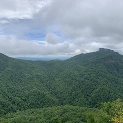
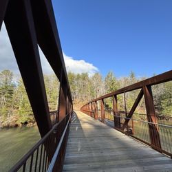
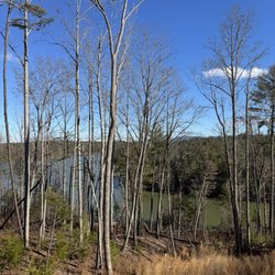
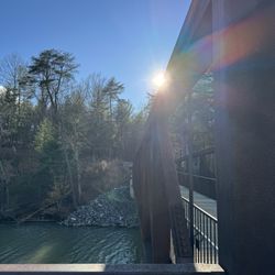
I think this should be Shortoff Mountain Trail (which starts at the end of Wolf Pit Road). From what I could find, there's no such thing as Wolf Pit Trail. This hike starts out fairly steep. It cuts off to the right (follow the sign) and then there's a series of switchbacks to the top of the mountain. It merges with the mountains to sea trail and then levels out after a bit. There are great views of Lake James and the mountains on the whole hike up. Once we got to the top, we continued on for a while past a pond to some more views of Table Rock. I thought the initial views at the summit were the best though. The estimates I saw for the hike were 4-5 miles, so I'm not quite sure exactly how long it was. The parking situation is pretty terrible. There's not really any good spots, but everyone kind of makes their own. I can't imagine how bad this would be in the summer. This is a great, not too strenuous hike with good views throughout. read more


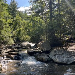
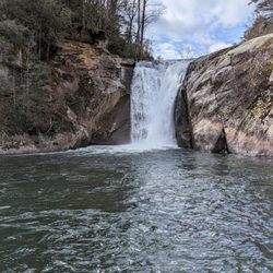
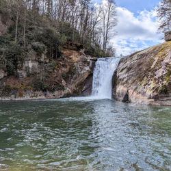
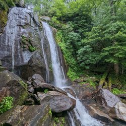
This hike contains it all! Beautiful views, ample camping possibilities, plenty of firewood for epic fires, river crossings, waterfalls, and the sound of a river rushing by to lull you to sleep at night. But it is not for the faint of heart or the introductory backpacker. The river crossing alone (at Spence bridge) was crazy. We did the 22 mile loop that starts and ends at Wolf pit Road. (Where this pin/review originates). Here's my advice: 1. Get a map. There are lots of moments where the trail is not clearly marked. The MST runs through part of the loop so the blazes in the trees are nice, but the loop also contains many other trails. Furthermore, there are lots of side hikes that one can take and/or parking possibilities for the start of the hike. We used the map at Linvillegorge.net. It has lots of little campsites and water spots. Mostly helpful along the way though there were a few times we had to backtrack because the map didn't match the actual trails we found. 2. Plan on getting wet...twice. There are two river crossings on the loop and lots of chances to swim if it's warm enough. The river crossings are a little technical, but I am also a novice at river crossings so this point probably doesn't mean much. 3. There is good deal of elevation change in this hike. Be ready for the ups AND downs. At Leadmine, be ready for several bits of both. 4. Just prepare yourself for lots of stopping and photo moments. The views throughout are SPECTACULAR. Bring your cameras, GoPros, etc. read more


5 years ago
More info about Wolf Pit Trail
Wolf Pit Rd
Morganton, NC 28655
Directions
Hours
Outdoor Amenities


Wolf Pit Trail - hiking - Updated June 2026
Best of Morganton
People found Wolf Pit Trail by searching for…
Hiking Trails With Waterfalls in Morganton, North Carolina
Things to Do in Morganton, North Carolina
Photo Spots in Morganton, North Carolina
River Swimming in Morganton, North Carolina
Beautiful Views in Morganton, North Carolina
Scenic Overlook in Morganton, North Carolina
Off Road Trails in Morganton, North Carolina
Waterfalls in Morganton, North Carolina
Scenic Views in Morganton, North Carolina
Waterfalls and Swimming Holes in Morganton, North Carolina
Walking Trails in Morganton, North Carolina
Running Trails in Morganton, North Carolina
View Points in Morganton, North Carolina
Tent Camping in Morganton, North Carolina
Night View in Morganton, North Carolina
Swimming Lakes in Morganton, North Carolina
Night Hike in Morganton, North Carolina
Easy Hikes in Morganton, North Carolina
Romantic Views in Morganton, North Carolina
Swimming in Morganton, North Carolina
Lakes & Ponds in Morganton, North Carolina
Views in Morganton, North Carolina
Trending Searches in Morganton, NC
Black Owned Nail Salons near Wolf Pit Trail
Boat Rental near Wolf Pit Trail
Cliff Jumping near Wolf Pit Trail
Dog Friendly Trails near Wolf Pit Trail
Fishing Spots near Wolf Pit Trail
Jet Ski Rental near Wolf Pit Trail
Kayak Rental near Wolf Pit Trail
Lakes & Ponds near Wolf Pit Trail
Off Road Trails near Wolf Pit Trail
Picnic Parks near Wolf Pit Trail
Public Pools near Wolf Pit Trail
Public Shower near Wolf Pit Trail
River Swimming near Wolf Pit Trail
Scenic Overlook near Wolf Pit Trail
Secluded Spots near Wolf Pit Trail
Soccer Store near Wolf Pit Trail
Splash Pad near Wolf Pit Trail
Strawberry Picking near Wolf Pit Trail
Sunrise View near Wolf Pit Trail
Swimming Holes near Wolf Pit Trail
Swimming Lakes near Wolf Pit Trail
U Pick Farms near Wolf Pit Trail
Watch Sunset near Wolf Pit Trail
Browse Articles
Browse Nearby
Browse Brands
Related Searches in Morganton, NC
Affordable Kayak Rental Services in Morganton, North Carolina
Best Fishing Locations and Guides in Morganton, North Carolina
Best Fun Things to Do in Morganton, North Carolina
Best Places for Horseback Riding in Morganton, North Carolina
Best Waterfalls and Swimming Holes in Morganton, North Carolina
Check Out Off Road Trails in Morganton, North Carolina
Discover Popular Photo Spots in Morganton, North Carolina
Discover Top Boat Tours in Morganton, North Carolina for All Ages
Discover a Hiking Trail in Morganton, North Carolina
Discover the Best Night Hike Trails in Morganton, North Carolina
Discover the Best Running Track in Morganton, North Carolina
Dog-Friendly Hikes With Dogs in Morganton, North Carolina
Enjoy Tent Camping Spots Around Morganton, North Carolina
Enjoy a Beautiful Waterfall Hike in Morganton, North Carolina
Enjoy the Best Tubing Experiences in Morganton, North Carolina
Exciting Cliff Jumping Spots in Morganton, North Carolina
Explore Beautiful Parks and Green Spaces in Morganton, North Carolina
Explore Fun Activities to Do in Morganton, North Carolina
Explore Popular Campgrounds Near Morganton, North Carolina
Explore Popular Scenic Overlook Points in Morganton, North Carolina
Explore Popular View Points Around Morganton, North Carolina
Explore Scenic Lakes to Visit in Morganton, North Carolina
Explore Secret Spots Worth Visiting in Morganton, North Carolina
Explore Top Dog Parks in Morganton, North Carolina Near You
Explore Top Water Parks in Morganton, North Carolina Today
Explore the Best Boating Spots in Morganton, North Carolina
Explore the Best Swimming Holes Around Morganton, North Carolina
Family Friendly Hiking With Kids in Morganton, North Carolina
Find Beautiful Views in Morganton, North Carolina
Find Parks and Recreation Activities in Morganton, North Carolina
Find Popular Ziplining Spots Around Morganton, North Carolina
Find Top Dog Swimming Spots in Morganton, North Carolina
Find Top-Rated Disc Golf in Morganton, North Carolina
Find the Best Parks for Picnics in Morganton, North Carolina
Find the Best Playgrounds to Visit in Morganton, North Carolina
Hiking Trails With Waterfalls in Morganton, North Carolina
Locate Tennis Courts Around Morganton, North Carolina
Off Leash Dog Hiking Trails in Morganton, North Carolina
Plan a Scenic Drive Route Near Morganton, North Carolina
Popular Fishing Spots to Explore in Morganton, North Carolina
Popular Kids Activities in Morganton, North Carolina
Popular Picnic Spots to Visit in Morganton, North Carolina
Popular Things to Do in Morganton, North Carolina
Safe River Swimming Areas in Morganton, North Carolina
Safe and Fun Parks for Kids in Morganton, North Carolina
Top Climbing Spots and Gyms in Morganton, North Carolina
Top Paddleboarding Activities in Morganton, North Carolina
Top Running Trails to Explore in Morganton, North Carolina