Cancel

    Open app

    Search

    Wildland Trekking

    5.0 (1 review)
    Open 9:00 am - 4:00 pm

    Wildland Trekking Photos

    You might also consider

    Recommended Reviews - Wildland Trekking

    Your trust is our priority, so businesses can't pay to alter or remove their reviews. Learn more about reviews.
    Yelp app icon
    Browse more easily on the app
    Review Feed Illustration

    9 years ago

    Helpful 0
    Thanks 0
    Love this 0
    Oh no 0

    You might also consider

    Verify this business for free

    Get access to customer & competitor insights.

    Verify this business

    Beaver Falls - Folks swimming.

    Beaver Falls

    4.9(13 reviews)
    1.4 mi

    This sure was an adventure to get to. Beaver falls is about 4 miles to get to once you leave camp…read more You'll pass Mooney Falls and that cave you have to climb down to get to Beaver Falls. Once you leave Mooney you'll pass through areas with tons of greenery all over, make a few river crossings (make sure you bring water shoes) do some more river crossings on some sketchy logs, climbs some sketchy ladders, then boom you're there. Beaver Falls was probably my second favorite water falls site here at Supai mainly because you can sit and relax in the upper cascade area or do a little swimming in the lower pool.

    Permit required This is as far as we went. Our 2nd to this…read morefall as well. First time here was the 2nd week of October. This year we went the last week of April. We reached the Falls around the same time so not much sun left as the canyon wall creates a large shaded area slowly. To get to this fall you will be crossing the creek a couple of times or maybe 3 times if you cross to early or late. Most of the time you will be in awe by the beauty as you trek along the way. But there is a part where you come around the corner of the canyon wall and it opens up into the vast open space and you see lush, green vegetation flanked by the canyon walls with shades of copper and hues of orange and brown. You have to stop yourself and soak in the beauty. Our first time going to Beaver Falls we were fortunate to see a big horn sheep, it was gorgeous. This time around we didn't get lucky, but some hikers we spoke to got some good pics of one. You will come across some sketchy parts to climb and see again when heading back to camp. Take your time and watch your footing. As you come down to Beaver we were told a ladder that was once there is now destroyed but there is a way but will need to tread the shallow water. It may change and they will replace the homemade ladder at some point. So you will need to find your own way or follow everyone else. This Fall has short cascading falls. Great for picture taking. A couple we met were going to use their photo for their engagement pic. The water is cold does not feel like 70 degrees as mentioned in a couple of reads on the FB Havasupai page. But that will not deter you from enjoying this beautiful spot. Head here early too so you can catch some rays while playing in the water.

    Photos
    Beaver Falls - Lunch break.

    Lunch break.

    Beaver Falls
    Beaver Falls

    See all

    Havasu Falls

    Havasu Falls

    4.1(185 reviews)
    1.4 mi

    There are places on this earth that don't feel entirely claimed by man where the air sits heavier,…read morewhere silence hums just a little too loud. Havasupai Falls is one of those places. Now listen I'm gonna tell you straight. You can hike it, sure. Strap on your pack, bake in that canyon heat, follow the mules and the dust like you're reenacting some pioneer tragedy. Or... you take the helicopter. Drop in like you've got better sense than the rest of 'em. Because when you're only staying a night, you don't waste half your trip pretending you enjoy suffering. You get there quick, boots on the ground, eyes wide open. And what waits for you... ain't normal. The water this unreal shade of blue, like someone spilled paint straight outta heaven itself cuts through red rock like it's been there since before memory had a name. The canyon walls stand tall, watching. Always watching. You can feel it. Not in a poetic way... in a you're not alone kind of way. The people there, the tribe they carry a quiet presence. Like they know something they're not in a hurry to explain. Respectful, grounded... but there's history in their eyes. Old history. Night comes different down there. The fire was crackling low. Shadows stretching just a little too far, bending where they shouldn't. That's when I saw it. Across the canyon, tucked behind a tree like it didn't quite understand hiding... something big. Hairy. Not a trick of the light. Not a deer. Not a man. It stood there. Watching. Then came the sound. Tap... tap... tap. Something hitting the tent. Not hard. Just enough to say, "I'm still here." I thought maybe rocks... maybe pinecones. But there weren't any trees above us that could explain it. And whatever it was it had aim. I told the others. Nobody laughed. Nobody slept. We sat around that fire like it was the last safe place on earth, eyes fixed into the dark, waiting for something to step forward... or worse, not step forward. Because sometimes what you don't see is worse than what you do. Finally, in a moment of pure, desperate brilliance or stupidity someone grabbed a sandwich and chucked it out there into the black. We waited. Minutes stretched. The canyon held its breath. And then... nothing. Whatever it was... it was gone. No footsteps. No sound. Just silence again, like the place had swallowed it whole. Now I ain't saying I believe in Bigfoot... ...but I'm also not saying I slept worth a damn that night. And here's the part where I switch gears for ya because after all that spooky nonsense, you gotta laugh a little. Look, I'm just gonna say it .. "I paid good money to fly into a canyon, not to get mugged by a damn woodland gorilla." You got folks hiking ten miles, riding donkeys, sweating like they owe the sun money... and I'm down there getting harassed by what I can only assume is the canyon's unofficial night manager. Five stars. Would absolutely go again. ...but next time, I'm bringing two sandwiches.

    Out in the middle of the desert in Arizona pretty much near the end portion of the Grand Canyon and…read moreabout an hour away from Route 66 is the trail to get to Havasupai. There's a lodge in the village and a campground area another 2 miles from the village, both have different dates to apply for permits online about a year in advance. There are 5 amazing water fall sites once you pass the village. 50 Foot Falls, Lower Navajo Falls, Havasu Falls, Mooney Falls, and Beavers. An additional journey heading out 6 miles past Beaver falls you can get to the Confluence where you can see the Havasu Creek water meet up with the Colorado river. For the camp sites you aren't assigned an actual location you just grab any available site that's not directly on the trail. There's a fresh water spring in the camp site where we refilled out bottles for the 4 days & 3 nights we were here. Also 2 miles back up at the village they do have a cafeteria with burgers fries, hot dogs and all that other stuff. If you're not up for the 8-10 miles hike into the village/campground with all your camping gear on your back they have options at additional cost. You can have your bags packed on miles/horses and carried into the site & they also have helicopter rides in and out of the village (first come first serve, the natives have priority to skip the line at anytime)

    Photos
    Havasu Falls
    Havasu Falls
    Havasu Falls

    See all

    Bright Angel Trail - The water here tastes so good and minerally ;)

    Bright Angel Trail

    4.7(123 reviews)
    33.8 mi

    This is the most popular hiking trail into Grand Canyon! Even though it is well-traversed, this is…read morealso a dangerous trail for people who are not prepared, as it's wayy easier hiking down...but you have to contend with the hike up. Also, there is limited water on the trail (and sometimes there are pipeline breaks), with not a lot of shade. With hot weather, this could be a deadly hike. The trail head has bathrooms and a water filling station. Definitely use them before hiking down. This hike is well maintained, with mules sharing the trail. You can see them...or at least smell them as they leave poop on the trail. I hiked down to the Second Tunnel (1.8 miles) and it wasn't too bad, but I was unfortunately limited on time. It seems past this point the crowds thinned out. Havasupai Gardens at 9 miles round trip is the most the rangers recommend as a day trip. I loved how the view of the Canyon changed as I descended the trail!

    Perhaps the most famous route in the Grand Canyon, or at least along the South Rim. That being…read moresaid, it's obviously well-travelled and therefore well marked. Water filling stations at the top. There are landmarks along the way, so you know how far you've gone (in case you're not tracking it on your watch or phone). We turned around at the second tunnel, which was 0.8 miles down apparently. Lots of signage at the Visitors Center and the trailhead that warn of the dangers. Definitely not the place to start if you're embarking on a serene backpacking trip, but a fun "I accomplished that" route for an extended day hike.

    Photos
    Bright Angel Trail
    Bright Angel Trail - Two very happy tourists from Iowa.

    Two very happy tourists from Iowa.

    Bright Angel Trail - TEAM

    See all

    TEAM

    South Kaibab Trail - Mules

    South Kaibab Trail

    4.7(90 reviews)
    37.0 mi

    If you really want to understand the Grand Canyon, you don't stand at the rim. You step off it…read more 
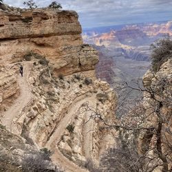
South Kaibab Trail is not subtle about what it is. There's no easing into it, no gentle introduction. Within minutes, you're descending through tight switchbacks, the rim already pulling away behind you, and that comfortable "overlook" perspective is gone. You're in it now. What makes this trail different is the exposure. It rides out along a ridge, not tucked away or hidden, so the views are constant. There's no point where it closes in or gives you a break. Every step opens something new. Layers of rock stacked like pages, colors shifting depending on where the sun hits, distances that feel close until you realize they're anything but. Early on, you hit that first real vantage point where everything just drops away in front of you. It's the kind of moment that interrupts whatever you were thinking about. You stop, not because you planned to, but because you don't really have a choice. And then you keep going. The trail pulls you downward at a steady, unapologetic grade. It's not technical, but it demands attention. Your footing matters. Your pacing matters. Knees start to take notice on the way down, and somewhere in the back of your mind, you're already aware that every step you're taking is one you'll have to reverse later. There's almost no shade. That's not an exaggeration. Once the sun is up, it owns this trail. That's why going early isn't just a good idea, it's the difference between a great hike and a brutal one. In the early hours, the light cuts across the canyon at an angle, pulling out depth and contrast you just don't get later. Shadows stretch, colors deepen, and the entire landscape feels more alive. By midday, it flattens out and the heat starts pressing down in a way that changes the tone completely. As you descend, the canyon shifts around you. The rock underfoot changes color and texture, walls rise and fall, and the sense of scale keeps slipping just out of reach. You try to make sense of distance, but it doesn't behave the way you expect. What looks like a short stretch can take far longer than it should. Landmarks move. Perspectives lie. There's a point where the noise fades out. Fewer people, more space, just the sound of your own steps and the occasional wind moving through the canyon. It's quiet in a way that feels earned. Not empty, just stripped down to what matters. And then there's the reality check. Going down is the easy part. It always is. The climb back up is where this trail makes its case. The grade doesn't soften. The exposure doesn't change. It's you, the incline, and however well you managed your energy on the way down. It's not impossible, not even close, but it demands respect. You feel it in your legs, your lungs, your pace slowing whether you like it or not. But that's also where something shifts. You're not just looking at the canyon anymore. You're moving through it, working against it, understanding it in a physical way that no overlook can give you. The scale stops being abstract. It becomes something you measure in effort, in time, in breath. By the time you reach the top again, you've earned a completely different perspective than the one you started with. This trail doesn't offer comfort. It offers clarity. It strips things down to effort, environment, and awareness. And in return, it gives you one of the most direct, honest ways to experience the Grand Canyon. Five stars, no hesitation.

    I have done Bright Angle Trial a couple of times in the past to the bottom of the Grand Canyon…read more South Kaibab is the other big trail into the Canyon. Over the summer, we camped at the rim and decided to hike South Kaibab a little ways early in the morning before it got too hot. We ended up hiking all the way to Skeleton Point and back. As it approached afternoon, it started to get a little warm. I ended drinking all the water in my CamelBak just before I got to the top. The temperature was climbing fast and I had to use my cooling towel to stay cool. I got to say that I really gained a lot of respect for this Canyon during this short summer hike that I did. The South Kaibab Trail is a 7 mile hiking trail in Grand Canyon National Park that leads to the Colorado River. I like this trail because you get 360-degree views of the canyon after you pass Skeleton Point. The trail is mostly shaded until you reach Ooh Aah Point. Then you are out in the open. Up next is Cedar Ridge at 1.5 miles and then Skeleton Point at 3 miles. After that is the Tipoff and Black Suspension Bridge as you are descending into the Canyon. There is no water on the trail until you get to the bottom of the canyon at Bright Angel Campground and Phantom Ranch. So bring plenty of it along with snacks, sunscreen, etc. The hike is 15 miles (24 km) roundtrip to Phantom Ranch and will take at least 2 days to complete. If you get to the beginning of the trail early enough, you can probably find parking in the parking lot or on the side of the road. But it fills up quick. Another option is to take the free shuttle to the trailhead from the South Rim Visitor's Center. Both water and restrooms are located at the beginning of the trail. The hike is usually a little busy with people to start off with, but many turn around after reaching Ooh Aah Point. It is also fairly steep with lots of switchbacks, so bring poles if you need them for assistance. Be prepared for a climb on the way back to the parking lot during that last mile. Also keep an eye out for Mules as they use this trail regularly. My recent hike was in June and I saw many people with little or no water. I also saw people with footwear that should not be worn on this trail. It blew me away how uneducated and naive people are about doing these hikes into the canyon. I understand lots of tourists come here, but people need to be a little more careful when hiking the Grand Canyon. Many of the deaths that occur every year in this Canyon can be avoided. On the day that I visited and hiked this trail, they reported several heat related incidents that evening and one death. South Kaibab Trail is a great hike. Enjoy, make a plan and be responsible.

    Photos
    South Kaibab Trail - Shuttle Pickup/Drop-off

    Shuttle Pickup/Drop-off

    South Kaibab Trail
    South Kaibab Trail

    See all

    The Rim Trail

    The Rim Trail

    5.0(20 reviews)
    31.7 mi

    This trail is very nice for everyone of all ages and for leashed pets! It's pretty well defined so…read moreyou won't get lost. Most of the trail is paved and some sections are even accessible. It's pretty flat. I would say it's great for a stroll, walking at whatever pace you want for quiet views of the inner canyon. The only drawback is that there's no water on the trail, so be prepared. There are primitive toilets along the trail. At the end of the trail at Hermit's Rest there's running water (and the gift shop with snacks). There are nine scenic overlooks along this trail, although all along the trail you will see amazing views. If you would rather bike, you can bike on the road that kind of follows the rim, or take the shuttle. There are also shuttle stops at various points, so if you only want to do a portion of the Trail that's also doable.

    Walking the Rim Trail was easily our favorite part of visiting the Grand Canyon. It's the perfect…read moreway to take in those iconic South Rim views, especially since it's dog-friendly! The path is mostly paved, though we did hit a few moderately steep sections along the way.  There aren't water stations or restrooms directly on the trail, so definitely fill up and use the facilities at the popular stops whenever you can. We drove in and found parking near the lodges (no parking fees). While there are benches and shuttle stations to rest at, keep in mind that dogs aren't allowed on the shuttles, so you'll be walking the whole way back if traveling with your pup. We visited in early March and were definitely glad to have jackets for the chilly weather.

    Photos
    The Rim Trail
    The Rim Trail
    The Rim Trail

    See all

    Colorado River via Mooney Falls - One of several ladder climbs from Mooney Falls to the Colorado River

    Colorado River via Mooney Falls

    5.0(1 review)
    1.4 mi

    18 MILES OF LUSH GREENERY AND PRESTINE WATER…read more STATS: 18 miles round-trip from campground Not recommended for Acrophobia's Very rugged and dangerous descent Slippery when wet, and it's always wet Minimal elevation gain or loss Freak-ton of water crossings A few ladders to climb Minimal rock scrambling ESSENTIALS: Know your limits 3 Liters of water, minimum. More during the warmer months Gloves Hiking shoes with netting for water drainage Swimwear Layered Clothing High protein food/snacks Electrolytes Camera Hat (optional) Sunscreen Trek poles (optional) OUR ROUTE: From our campsite at Havasu Falls, me and The Crew started out this amazingly jaw dropping 18 miler by heading down to the bottom of Mooney Falls via handrails made of chains and wooden ladders. Once everyone was at the bottom of Mooney Falls, we followed and crossed the vibrant blue water that is the perfect contrast against the striking red rocks of the canyon walls. At times the trail seems to hide, however, hiking to the Colorado is just a matter of following the downward flowing creek since the creek eventually converges with the Colorado. Once the Colorado River was in sight, we did a little upward rock scrambling and down the other side where we ate lunch on enormous flat rocks. While the water temperature of the Havasu water was comfortable to soothing with a calm flow, even in the cooler air temperatures, the Colorado River water was quite a bit cooler and ran fast. If you choose to take a dip in the Colorado, be sure you are a strong swimmer, otherwise you will be swept down the river. On the nine miles back to camp we stopped off at Beaver Falls for a swim, a jump and a few pics in the rock walls. Due to the gritty bottom of the falls, best to keep your shoes on. Those daring enough to jump off the rocks be warned there are areas where there are strong under toes that will open Velcro pockets and snatch your camera, that's what happened to a fellow hiker. After several attempts of diving below to look for it this strong hiker and former professional divers energy were expanded from the pulling of the under toes. There are no lifeguards on duty, so everything you do is at your own risk. Our path back to Mooney Falls was slightly different than our trek down, and the views were just as amazingly beautiful. Remember, there are no maids or clean-up crew, keep this part of Mother Nature cleaner than you found it. Pack out what you pack in and pick up what you can. DISCLAIMER: Hiking is not something that can be taken lightly. It can be life-threatening as you see and hear on the news, people die or get lost all time. Please, if you are going to hike, never go alone and prepare for the worst, hope for the best. Remember when going for a hike, no matter how short you think it may be, always be prepared. Carry at least two liters of water for every five miles (more if the weather is warm), protein bar, nuts, and electrolytes. Wear sturdy lug sole shoes and protective clothing. Some areas the weather can change quicker than a fireman can put on his gear. It is also very important, always always always let a family member or friend know where you are going and when you expect to be back. Lastly, have fun when you hike it up.

    Photos
    Colorado River via Mooney Falls - A Freak-ton of water crossing from Mooney Falls to the Colorado River

    A Freak-ton of water crossing from Mooney Falls to the Colorado River

    Colorado River via Mooney Falls - Cascading Havasu Falls water heading to the Colorado River

    Cascading Havasu Falls water heading to the Colorado River

    Colorado River via Mooney Falls - Dried up waterfall

    See all

    Dried up waterfall

    Plateau Point - Gorgeous day to Plateau Point

    Plateau Point

    5.0(4 reviews)
    34.1 mi

    Probably one of the best but brutal hikes I have been on in awhile…read more I went with the AZ Trailblazers Hiking Club on this rim to Plateau Point 13 mile 3,000 feet elevation change in and out hike and so glad I did this hike. I actually wasn't too sure I was going to be able to finish because my right knee really started to hurt once down at Havasupai Gardens. But, I'm not someone that gives up, so I just told myself I would just push through the pain. We hiked another 1.5 miles to Plateau Point and what a beautiful spot, you can see right down into the Colorado River. I would love to be out here when its dark to see the night sky, will work on making that happen! The ascent is challenging, no matter who you are, but when you finally hit the top, victory is just so sweet! Highly recommend this hike for its beautiful views and make sure to mentally prepare for it. It is a meditative experience.

    I stood on the precipice, gazing down at the mighty Colorado River below. There was a faint whisper…read moreof the rapids below, and the winter sun of late afternoon was slowly sinking to the west, casting long shadows from the mighty canyon cliffs and covering much of the winding, chocolate river below in dark hues of brown, buff, and muted orange tones. At that moment, the pot of water on top of my backpacking stove began to boil and I retreated from the edge to turn off the stream of isobutane, remove the water, and mix the hot water with freeze-dried meals for me and my backpacking partner so we could enjoy dinner. A few minutes later we were back on the edge at the guardrail, slowly eating our dinner and letting the hot, salty food warm us from within while the last few moments of sunshine glowed on our faces. And that was the moment. That was the moment of complete peace, and direction, and clarity. Every decision we had made in our lives, up to that point, had led us to this point. Our friendship, our adventurous spirit, our very decision to embark on a trek to the Grand Canyon and every little thing had fallen in place to take us to the edge of Plateau Point where we knew that everything was going to be okay. I think back often on that moment. It's been a year and a half, but I can still feel the chilly January breeze, and also the absolute peace that accompanied it. We had wandered into the Arizona desert with questions and Plateau Point had spoken to us with answers. The sage and saguaro spoke wisdom to our hearts. Getting to Plateau Point, in the literal sense, is no small feat. It's down the Bright Angel Trail, emphasis on DOWN. They warn you that going down the Grand Canyon is optional, but going up is not. You must first hike the 4.5 miles (7.25km) to Indian Garden (listed separately here on Yelp) and that includes about 3000ft (915m) in elevation loss. From there, the trail out to Plateau Point is actually remarkably flat, dropping less than 100 feet (30m) on an additional 1.5 miles (2.4km) of trail. At the very edge of Plateau Point, you get to peer over massive cliffs and catch your first view of the River, but it's still about 1300ft (400m) below you. The views are legendary. If you're planning on this as a day hike, start extremely early in the day, and I wouldn't do it in the dead of summer. Those distances above are one way, so to start at the rim and make it back, you're going a full 12 miles (19.3km) and that's down 3000ft (915m) and back up again. It's brutal, and should only be attempted by seasoned hikers. If you're going as an overnighter, it's a bit more manageable. You can stay at Indian Garden in the campground (permits required) and drop your pack and go out as a leisurely stroll. The latter was our plan. That's how we arrived at Plateau Point, in the literal sense. But in the figurative sense we arrived at the overlook by making every decision we had ever made. And if you live the kind of life where every decision you make leads you to a time and place when the sun is setting and you're eating dinner while looking out on the Colorado in this sacred Canyon with a good buddy, then your life is going to be okay. Now, I don't know where life will take me next. I don't know what trail is ahead of me. Sometimes I think I see what may be on the trail, sometimes I wish beyond anything I've wished for before just to lace up my shoes and head off on an adventure, only to be held back alone at the trailhead. But I know no matter what, I was once at the edge of Plateau Point and everything was okay, and everything can be okay again.

    Photos
    Plateau Point - Beautiful Colorado River

    Beautiful Colorado River

    Plateau Point - Sunset, 9/23/18

    Sunset, 9/23/18

    Plateau Point - Rafters below the point down in the Colorado

    See all

    Rafters below the point down in the Colorado

    Wildland Trekking - tours - Updated May 2026

    Loading...
    Loading...
    Loading...