Ooh Aah Point Photos


You might also consider
More like Ooh Aah Point
Recommended Reviews - Ooh Aah Point
Start your review...

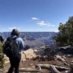
Absolutely a must do while here in the Grand Canyon. This hike is gorgeous, pretty easy for the most part, can be much longer than to the point and is part of the Kaibab trail. Endless miles of non stop stunning views and some man made stairs to help along the way. We took the orange line shuttle from the visitor center and it was easy and well worth it. We saw mule deer and elk along the way. Bring water, a hat, multiple layers and a snack, the temperature changes drastically as you head down into the canyon. The incline can definitely be a challenge if you are not used to hiking and the switch backs can be a scramble so good shoes are a must. No restrooms so use them before you hike. Enjoy! read more


Amazing views! But that incline though has me dying. I would not recommend doing this as a mid-day hike because once the sun hits around 10:30AM that heat will hit you like a freight train since there is no shade. Bring 3 liters of water at least and definitely sunnies and a hat. read more

The round-trip distance from South Kaibab Trail head to Ooh Aah Point is 3.2 miles, first down and then up, Ooh first and then Aah, the elevation is about 750ft, (some apps record 975ft), the slope is very steep. This Trail is considered the easiest one in the Grand Canyon and should be called taste of Grand Canyon. There are all kinds of people on the trail, male female, young and old. When you arrive at Ooh Aah, the scenery also has Ooh and Aah. It took a lot of effort to climb back to the trailhead, but it was not as difficult as imagined. It took a total of two hours, and another extra hour should get us to reach Cedar Ridge. read more


More info about Ooh Aah Point
S Kaibab Trl
Grand Canyon National Park
Grand Canyon, AZ 86023
Directions
Hours
Outdoor Amenities


Ooh Aah Point - hiking - Updated May 2026
Best of Grand Canyon
People found Ooh Aah Point by searching for…
Things to Do in Grand Canyon, Arizona
Visitor Centers in Grand Canyon, Arizona
Hiking Trails in Grand Canyon, Arizona
Things to Do at Night in Grand Canyon, Arizona
Beautiful Views in Grand Canyon, Arizona
Waterfalls in Grand Canyon, Arizona
Running Trails in Grand Canyon, Arizona
To Do in Grand Canyon, Arizona
Trail in Grand Canyon, Arizona
Easy Hikes in Grand Canyon, Arizona
Scenic View in Grand Canyon, Arizona
Stair Climbing in Grand Canyon, Arizona
Walking Trails in Grand Canyon, Arizona
View Points in Grand Canyon, Arizona
Views in Grand Canyon, Arizona
Off Road Trails in Grand Canyon, Arizona
Off Leash Dog Hikes in Grand Canyon, Arizona
Must See in Grand Canyon, Arizona
Watch Sunset in Grand Canyon, Arizona
Stuff to Do in Grand Canyon, Arizona
Browse Nearby
Browse Brands
Browse Articles
People who viewed Ooh Aah Point also viewed
Bright Angel Trail
123 reviews
North Kaibab Trail
9 reviews
The Rim Trail
20 reviews
Pygmy Guides
34 reviews
Hermit Road
5 reviews
Way Far Out Adventures, LLC.
3 reviews
Grand Canyon National Park Lodges-South Rim
28 reviews
Cape Royal Road
2 reviews
Grand Canyon
22 reviews
Tusayan Greenway Trailhead - Arizona Trail
1 review