Whitehouse Ridge Trail Photos


You might also consider
More like Whitehouse Ridge Trail
Recommended Reviews - Whitehouse Ridge Trail
Start your review...

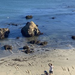
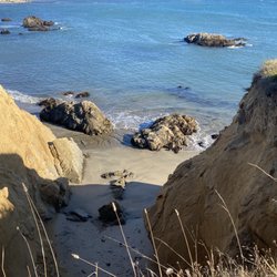
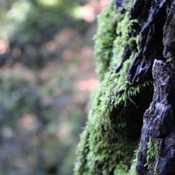
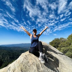
I'm sure if you read my reviews you'll see that I sound like a broken record when I talk about all the nature and hiking around the Bay Area. Yet, I'm still amazed when I discover a new area like the redwood-lined woods along the Whitehouse Ridge Trail. This trail is hidden away off the Pacific Coast Highway between Santa Cruz and Half Moon Bay, a place I find myself weekly. However, I only recently discovered this trailhead down Whitehouse Canyon Road. You'll have to be vigilant to notice the street because it's unmarked off of the PCH 1, but about 2.3 miles up a very uneven dirt road you'll come to a little parking area right before a private residence area. The Whitehouse Ridge trail is 1.2 miles but moderately strenuous in my opinion (maybe a little less depending on your fitness level) but is worth it for the totally amazing views of Franklin Point, Pigeon Point lighthouse, and Año Nuevo Point. You can choose the lower vista for a short hike or go up to the higher vista point for better views and further exploration amongst the redwoods. This area skirts Big Basin State Park and continues onto Chalk Mountain to eventually connect with the West Ridge Trail. To do the whole thing from Whitehouse Ridge to West Ridge would take all day so do some exploring before you attempt it all because it would not be a walk in the park (heh). This is one of my favorite hikes in Northern California. If you're looking for a moderate hike in a shaded area try this. Here's a link to a Google maps with markers to aid you: https://goo.gl/zx0e2b read more
 - Hiking Near Me")


More info about Whitehouse Ridge Trail
Pescadero, CA 94060
Directions
Visit Website
https://www.parks.ca.gov/?page_id=27619
Hours
Outdoor Amenities
You might also consider


Whitehouse Ridge Trail - hiking - Updated May 2026
Best of Pescadero
People found Whitehouse Ridge Trail by searching for…
Snow Park in Pescadero, California
Things to Do in Pescadero, California
Beach Bonfire in Pescadero, California
Hiking Trails in Pescadero, California
Fishing Spots in Pescadero, California
Redwood Trees in Pescadero, California
River Swimming in Pescadero, California
View Points in Pescadero, California
Picnic Areas in Pescadero, California
Walking Trails in Pescadero, California
Playgrounds in Pescadero, California
Off Road Trails in Pescadero, California
State Park in Pescadero, California
Scenic Drive in Pescadero, California
Sunset View in Pescadero, California
Secret Spots in Pescadero, California
Canyoneering in Pescadero, California
Scenic View in Pescadero, California
Trail in Pescadero, California
Things to Do on a Rainy Day in Pescadero, California
Natural Hot Springs in Pescadero, California
Picnic in Pescadero, California
Trending Searches in Pescadero, CA
Baseball Fields near Whitehouse Ridge Trail
Boat Rental near Whitehouse Ridge Trail
Botanical Gardens near Whitehouse Ridge Trail
Bounce House Rentals near Whitehouse Ridge Trail
Campgrounds near Whitehouse Ridge Trail
Cherry Picking near Whitehouse Ridge Trail
Cliff Jumping near Whitehouse Ridge Trail
Dog Friendly Things To Do near Whitehouse Ridge Trail
Fishing Lake near Whitehouse Ridge Trail
Flower Fields near Whitehouse Ridge Trail
Flower Shop near Whitehouse Ridge Trail
Garage Sales near Whitehouse Ridge Trail
Hair near Whitehouse Ridge Trail
Lakes & Ponds near Whitehouse Ridge Trail
Nurseries & Gardening near Whitehouse Ridge Trail
Off Leash Dog Parks near Whitehouse Ridge Trail
Outdoor Activities near Whitehouse Ridge Trail
Outdoor Basketball Courts near Whitehouse Ridge Trail
Outdoor Furniture Stores near Whitehouse Ridge Trail
Party Equipment Rentals near Whitehouse Ridge Trail
Pedicure near Whitehouse Ridge Trail
Pick Your Own Farms near Whitehouse Ridge Trail
Picnic Areas near Whitehouse Ridge Trail
Picnic Spots near Whitehouse Ridge Trail
Places To Take Pictures near Whitehouse Ridge Trail
Plant Nursery near Whitehouse Ridge Trail
Public Beaches near Whitehouse Ridge Trail
Rock Quarry near Whitehouse Ridge Trail
Running Trails near Whitehouse Ridge Trail
Scenic Drive near Whitehouse Ridge Trail
Secret Spots near Whitehouse Ridge Trail
Splash Pad near Whitehouse Ridge Trail
Strawberry Picking near Whitehouse Ridge Trail
Sunrise View near Whitehouse Ridge Trail
Swimming Holes near Whitehouse Ridge Trail
Tennis Courts near Whitehouse Ridge Trail
Browse Nearby
BEST of Pescadero, California Restaurants near Whitehouse Ridge Trail
BEST of Pescadero, California Parks near Whitehouse Ridge Trail
BEST of Pescadero, California Coffee near Whitehouse Ridge Trail
BEST of Pescadero, California Things to Do near Whitehouse Ridge Trail
BEST of Pescadero, California Breakfast near Whitehouse Ridge Trail
BEST of Pescadero, California Beaches near Whitehouse Ridge Trail
BEST of Pescadero, California Hotels near Whitehouse Ridge Trail
BEST of Pescadero, California Campgrounds near Whitehouse Ridge Trail
BEST of Pescadero, California Glamping near Whitehouse Ridge Trail
Browse Brands
Related Searches in Pescadero, CA
Affordable Kayak Rental Services in Pescadero, California
Best Fishing Locations and Guides in Pescadero, California
Best Nature Trails for Hiking in Pescadero, California
Best Off Leash Dog Parks in Pescadero, California
Best Parks for Parties and Events in Pescadero, California
Best Places for Horseback Riding in Pescadero, California
Best Water Parks for Kids in Pescadero, California
Best Waterfalls and Swimming Holes in Pescadero, California
Check Out Great Playgrounds in Pescadero, California
Check Out Off Road Trails in Pescadero, California
Discover Baseball Fields Around Pescadero, California
Discover Dog Friendly Trails to Explore in Pescadero, California
Discover Fun Toddler Parks in Pescadero, California for Your Little One
Discover Lakes & Ponds to Explore in Pescadero, California
Discover Popular Photo Spots in Pescadero, California
Discover Public Beaches to Visit in Pescadero, California
Discover Scenic Mountain Bike Trails Near Pescadero, California
Discover Soccer Fields in Pescadero, California Near You
Discover Top Nature Parks to Visit in Pescadero, California
Discover a Hiking Trail in Pescadero, California
Discover the Best Beaches in Pescadero, California
Discover the Best Kids Park Spots in Pescadero, California
Discover the Best Night Hike Trails in Pescadero, California
Discover the Best Running Track in Pescadero, California
Dog-Friendly Hikes With Dogs in Pescadero, California
Enjoy Camping Adventures Around Pescadero, California
Enjoy Exciting Mountain Biking Adventures in Pescadero, California
Enjoy Tent Camping Spots Around Pescadero, California
Enjoy a Beautiful Waterfall Hike in Pescadero, California
Enjoy a Dog Beach Day in Pescadero, California
Enjoy the Best Picnic Spots and Ideas in Pescadero, California
Enjoy the Best Walking Trails in Pescadero, California
Exciting Cliff Jumping Spots in Pescadero, California
Experience Thrilling White Water Rafting in Pescadero, California
Explore Beautiful Botanical Gardens in Pescadero, California
Explore Beautiful Parks and Green Spaces in Pescadero, California
Explore Easy Hikes Perfect for All in Pescadero, California
Explore Family-Friendly Zoos and Wildlife in Pescadero, California
Explore Free Picnic Areas Around Pescadero, California
Explore Fun Activities to Do in Pescadero, California
Explore Parks With Pull Up Bars in Pescadero, California
Explore Popular Campgrounds Near Pescadero, California
Explore Popular Picnic Areas Around Pescadero, California
Explore Popular RV Parks Around Pescadero, California
Explore Popular Recreation Centers Around Pescadero, California
Explore Popular View Points Around Pescadero, California
Explore Scenic Lakes to Visit in Pescadero, California
Explore Top Dog Parks in Pescadero, California Near You
Explore the Best Beach Spots in Pescadero, California
Explore the Best Swimming Holes Around Pescadero, California
Browse Articles
People who viewed Whitehouse Ridge Trail also viewed
Audrey's Way at Mindego Gateway
2 reviews
Rancho Del Oso Nature and History Center
3 reviews
Lincoln Park
8 reviews
San Vicente Redwoods
2 reviews
Vista Slope
3 reviews
The Alumni Green
1 review
Greyhound Rock State Marine Conservation Area
2 reviews
Sierra Club Hikers Hut
4 reviews
San Tomas Aquino Creek Trail
4 reviews
Matadero Creek Trail
1 review