Cancel

    Open app

    Search

    Topaz Mountain

    4.0 (2 reviews)

    Topaz Mountain Photos

    Recommended Reviews - Topaz Mountain

    Your trust is our priority, so businesses can't pay to alter or remove their reviews. Learn more about reviews.
    Yelp app icon
    Browse more easily on the app
    Review Feed Illustration

    2 years ago

    Helpful 0
    Thanks 0
    Love this 0
    Oh no 0

    5 years ago

    Helpful 0
    Thanks 0
    Love this 0
    Oh no 0

    Verify this business for free

    Get access to customer & competitor insights.

    Verify this business

    Maple Canyon - Typical view of Maple Canyon from the deepest part of the canyon (next to the creek). - - Tom Brody

    Maple Canyon

    5.0(2 reviews)
    123.3 km

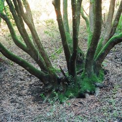
    MY PHOTOGRAPHS. Attached are photos showing panoramic views of Maple Canyon, where I took these…read morephotos from either Vista Peak Loop Trail (located on southern slope of Maple Canyon) or from Ziele Creek Trail (located on northern slope of Maple Canyon). Also attached are photos of trees covered with an awesome evening gown consisting of bright green moss. In addition, attached is a photograph of my assistant, Strawberry Shortcake, standing next to a little waterfall in Ziele Creek. NAMES OF THE TRAILS AND THE CREEK. For orientation, I first describe the trail that runs from east-to-west and resides on the slope to the NORTH of Ziele Creek, and regarding the trail that runs from east-to-west and resides on the slope to the SOUTH of Ziele Creek. The trail to the north is Ziele Creek Trail, and the trail to the south is Garin Woods Trail. These two trails form a stringed bean-shaped loop trail with Ziele Creek running through the center of the stringed bean. I walked in dry parts of the streambed of Ziele Creek and, in this way, explored all of the areas within the stringed bean loop trail. A bridge is easy to find at the eastern tip of the stringed bean loop trail, but I was not able to find any bridge at the western tip of the stringed bean loop trail. 
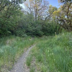
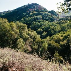
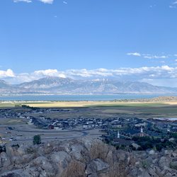
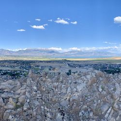
STARTING YOUR HIKE. The views of Maple Canyon from trailhead (located at the end of Calhoun Street) and from the nearby parts of Vista Peak Loop Trail are magnificent. Part of my day's hike was also along Ziele Creek Trail, which is located on the northern slope above the creek. In some parts, Ziele Creek Trail is forty meters above the creek, and this provides a splendid view of the tree-covered center of Maple Canyon and of the little groves of deciduous trees that find a home in isolated spots of Maple Canyon. The lowest parts of the canyon takes the form of a shady forest, and the surrounding areas take the form of a vast field of light-colored dried grasses. For starting my hike, I used the trailhead located at the eastern terminus of Calhoun Road. I parked in the dirt at the side of the road. Starting from the trailhead at the end of Calhoun Road, after a couple of minutes hiking to the southeast on Vista Peak Loop Trail, I arrived at a fork in the trail, and I took the downhill fork. After a minute on this downhill path, there is another fork in the trail, where there is a choice between taking a higher elevation trail called Garin Woods Trail and a lower elevation trail, also called Garin Woods Trail. The lower elevation trail is located deep in the canyon, and about thirty feet above Ziele Creek. SCENERY IN THE SHADE. Ziele Creek resides at the lowest point in Maple Canyon. Ziele Creek flows from east to west. Garin Woods Trail provides a view of many ferns and of trees covered with bright green moss and, here and there, you can see Ziele Creek between the trees, where the creek is about thirty feet below Garin Woods Trail. After hiking eastwards for 30 minutes on Garin Woods Trail, I decided to go off-trail and hike down the slope, and then hike westwards in the stoney stream bed for about 30 minutes, taking photographs of parts of the creek that contained pools of water, and that contained a tiny waterfall. The map on mapcarta.com shows the part of Garin Woods Trail that is near the stream, and it also shows the part of Garin Woods Trail that is higher up on Vista Peak. Google maps completely disregards Garin Woods Trail, and it gives you the false impression that the only trail near Ziele Creek is the one called, Ziele Creek Trail. Google maps shows only the half of the stringed bean-shaped loop trail that runs parallel to and is close to the north bank of Ziele Creek. PARKING AREA WITH MANY MORE PARKING SPOTS. Park on Thorup Lane or on Ziele Creek Drive. Trailhead is where these two small streets meet each other. COMPLETING THE STRINGED-BEAN SHAPED LOOP TRAIL. On two occasions in January 2021, I hiked the entire stringed bean-shaped loop trail (described above). The following problem applies to the western end of the stringed bean-shaped loop trail. On both occasions, I was not able to find any bridge that allows you to get from the northern slope of Maple Canyon, and then over the creek, and to the southern slope of Maple Canyon. Instead of taking any trail that crossed the creek with a bridge, I hiked down the northern slope of Maple Canyon, jumped over a shallow part of the creek, and then left the creek area by crawling up the southern slope of Maple Canyon. Because the southern slope that rises above the creek is steep, I crawled up using an improvised zig-zag path. Actually, I walked up (I didn't crawl up) and I grabbed any available roots and nearby branches in order to pull myself up the steep slope. In this way, I easily got back to Garin Woods Trail, and from there returned to my parking spot at the end of Calhoun Street. I hope some that that I can find a bridge across this part of the creek.

    Photos
    Maple Canyon - View of Maple Canyon from Ziele Creek Trail on the northern slope above Maple Canyon. - - Tom Brody

    View of Maple Canyon from Ziele Creek Trail on the northern slope above Maple Canyon. - - Tom Brody

    Maple Canyon - Beautiful moss-covered cluster of trees on northern slope, several feet above the creek. - -Tom Brody

    Beautiful moss-covered cluster of trees on northern slope, several feet above the creek. - -Tom Brody

    Maple Canyon - My assistant, Strawberry Shortcake, standing at a little waterfall at Ziele Creek. - - Tom Brody

    See all

    My assistant, Strawberry Shortcake, standing at a little waterfall at Ziele Creek. - - Tom Brody

    Baker Lake/Johnson Lake Trail - Baker Lake

    Baker Lake/Johnson Lake Trail

    4.5(2 reviews)
    129.2 km

    Baker Lake was my first backpacking trip…read more We started our hike up at 9:30 AM and arrived at Baker Lake around 1:30 PM. The hike up was strenuous because of our packs and the elevation gain. The trails are well marked though and the scenery was very nice. We were able to set up camp not far the lake. The trout were biting and we were able to catch a few. We enjoyed our over night stay at Baker Lake. It was peaceful and the stars & moon lit up the night sky. All the backpackers and hikers we saw on the trail were very friendly.

    located on Baker Creek area in Great Basin NP. near Lehman Caves Visitor Center…read more You will drive through a well maintained dirt road about three miles long. On the way, you'll pass the towering Grey Cliffs and Grey Cliff group campsite, an RV dump facility, and the Baker Creek campground. At the end of the road is a parking area for the trailhead for the Baker Creek and South Fork Baker Creek/Timber Creek trails. The elevation here at the trailhead is 8,000 feet. The NPS newsletter shows the Baker and South Fork Baker Creek trails as starting out as a single trail, but the signage at the trailhead is different, it shows the trails start out separately, with the Baker Creek trailhead about 20 yards north of the South Fork trail. Both trailheads are on the western side of the parking lot. My boyfriend and I hiked this trail yesterday and we had a little difficulty with the altitude. Make sure you take water, food and sunscreen. The breeze coming off the frozen creek is chilly on this shaded trail so be prepared to throw on some extra layers as needed. Most of this hike will be in tree cover. You will see beautiful high alpine meadow with a few aspen groves. Baker Creek trail is 3.1 miles RT with starting elevation of 8,0000. A moderate hike through a forest with ponderosa pines, beautiful meadows with views of Pyramid Peak, Wheeler Peak and Baker Peak. You will pass several beautiful creeks, some switchbacks and loose rocks but follow the trail. We saw wild turkeys. It was an enjoyable experience, and a very serene atmosphere.

    Photos
    Baker Lake/Johnson Lake Trail
    Baker Lake/Johnson Lake Trail
    Baker Lake/Johnson Lake Trail

    See all

    Great Basin National Park - Trees in Autumn  09-21-2025

    Great Basin National Park

    4.4(72 reviews)
    127.9 km

    Great Basin National Park is a relatively small portion of the Great Basin as a whole. There is no…read moreNational Park entrance fee required to visit. Per Google: "The Great Basin is a large, arid region in the western United States, defined by its geography and centered on Nevada. It is situated between the Sierra Nevada and Cascade ranges to the west and the Rocky Mountains to the east. The region includes most of Nevada, about half of Utah, and parts of Idaho, Wyoming, Oregon, and California." While planning our visit, I looked on the nps.gov website, I saw that there are cave tours. I signed up for the Lehman Cave Parachute Shield Tour. The tickets are purchased from recreation.gov website. We started off with a visit to the Great Basin Visitor Center where we looked at exhibits and got a general feel for the area. We bought a few small souvenirs and were on our way! I must say that the park was super beautiful with the changing of the leaves! Parts of the mountains were lit up with red & gold foliage! We drove the Wheeler Peak Scenic Drive all the way to the Wheeler Peak Overlook. Go slow-ish and enjoy the views! We stopped by: Osceola Ditch Trail - was a man-made waterway used for mining Wheeler Peak Summit Trail Summit Trailhead Bristlecone-Alpine Lakes Trailhead Mather Overlook Wheeler Peak Overlook - end of the scenic drive and has an awesome view of [yes!] Wheeler Peak Wheeler Peak Overlook is the final destination of the scenic drive. There are stops along the drive. Since we weren't hiking, we stopped at most of the pull-outs and parking lots. Wheeler Peak stands at 13,063 feet and is the second tallest point in Nevada! There are viewing scopes you can use to get a closer look! We made a quick stop at Mather Overlook. You can see Wheeler Peak from here as well. This overlook is named for Stephen Mather, the first director of the National Park Service (NPS). There's a cool bronze relief map of the Wheeler cirque. Then we drove back down to the Lehman Caves Visitor Center for our tour. The tour was very informative and was roughly an hour long. We stayed in Ely, NV which suited our needs. Baker, NV seemed pretty desolate from what I saw driving on the NV-487. Great Basin National Park is fairly remote compared to other National Parks, but definitely worth coming out to visit at least once!

    This review is for Baker Creek Loop which was a ~3.5 miles round trip that took ~2 hours to…read morecomplete. With the unexpected closure of the last 10 miles of Wheeler Peak Scenic Drive, we had no choice but to do a different hike in the area. Baker Creek Loop was a scenic forest trail with a meadow halfway through. Starting the trail clockwise; trail was an incline up the mountain and a decline back down to the aspen forest. Fall colored aspens were prominent at the start and end of the trail! Wooden bridges were slippery with ice. Decent sized parking area at the trailhead. Restroom available at the parking lot. Required to drive on gravel road for ~3 miles. Short video of the hike for those interested! https://youtu.be/gmfUHF9BAc0

    Photos
    Great Basin National Park
    Great Basin National Park
    Great Basin National Park - 09-21-2025

    See all

    09-21-2025

    Topaz Mountain - hiking - Updated May 2026

    Loading...
    Loading...
    Loading...