Swibold Trail Photos


You might also consider
More like Swibold Trail
Recommended Reviews - Swibold Trail
Start your review...

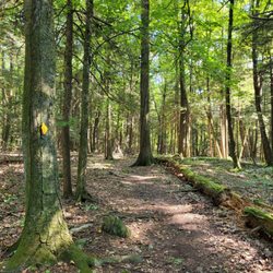
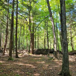
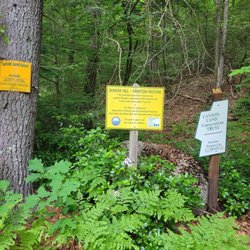
Swibold Trail goes through the 11-acre preserve and is part of the Canton Land Conservation Trust. It was donated to CLCT by Dick and Gretchen Swibold in 2018. It's located off of Cherry Brook Rd. (East side) next to # 731. Per the CLCT website, it's a 0.7-mile lollipop loop trail. There was a parking lot that can fit about 3 vehicles. At the start, there was a narrow trail that descends and it was well marked with yellow rectangles. There was a wooden bridge over a small brook. My family and I took a right and went to the confluence between Cherry Brook and Small Brook; such a serene spot, hearing the water flowing, and the smell of nature. We continued onwards and saw the 18th/19th century dam remnants; a brick wall with moss, it looked historic. The trail has ascends, descends, rocks, and roots; however, it was a fairly easy hike and I think kid-friendly. There were views of Cherry Brook from above. Overall, we loved hiking this trail and it's super serene. read more


More info about Swibold Trail


Swibold Trail - hiking - Updated July 2026
Best of Canton
People found Swibold Trail by searching for…
Things to Do in Canton, Connecticut
Walking Trails in Canton, Connecticut
Hiking Trails in Canton, Connecticut
Easy Hikes in Canton, Connecticut
Playgrounds in Canton, Connecticut
Scenic View in Canton, Connecticut
Off Leash Dog Hikes in Canton, Connecticut
Secret Spots in Canton, Connecticut
Waterfall Hike in Canton, Connecticut
Secluded Spots in Canton, Connecticut
Fun Things to Do at Night in Canton, Connecticut
Running Trails in Canton, Connecticut
Dog Friendly Trails in Canton, Connecticut
Scenic Overlook in Canton, Connecticut
Swimming Lakes in Canton, Connecticut
Off Road Trails in Canton, Connecticut
Lookout Points in Canton, Connecticut
Picnic Areas in Canton, Connecticut
Swimming Holes in Canton, Connecticut
Places to Take Pictures in Canton, Connecticut
Bonfire in Canton, Connecticut
Fun Things to Do With Kids in Canton, Connecticut
People who viewed Swibold Trail also viewed
Farmington River Trail
1 review
Hockanum River Hiking Trail
4 reviews
Horse Guard State Park
3 reviews
Farmington Canal Heritage Trail
7 reviews
Noel Baker Trail
1 review
Hop River State Park Trail
12 reviews
60 Westledge Trails
2 reviews
Windsor Center River Trail
3 reviews
Bunker Hill Trailhead
1 review
Collinsville Walking Trail
1 review