Sgt Michael Strank Memorial Park Photos


More like Sgt Michael Strank Memorial Park
Recommended Reviews - Sgt Michael Strank Memorial Park
Start your review...

6 years ago
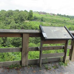
A lot has changed since the last review for this park was posted. If you look back at the pictures attached to that review you will see that there was not much to this plot of land back then. What makes this interesting though is the link to history that it has. Might I say, Johnstown sure has some interesting little gems in the area. The park itself is a bit hard to find. The address says Main St, but it's not the Main St located in Downtown Johnstown. Instead this is located in the Franklin section of the area. GPS will get you near, but not to the exact place. If, you are like me, and don't pay attention to the area, you will drive right by it. I had to turn around and come back. In the five years from the initial review and mine, the landscape of the park has changed drastically. There is now a walkway to bring you into the area and more to the memorial itself. It is a peaceful area to sit if you like as there is one bench. Parking is a bit odd as it is on a hill. So prepare yourself for a bit trek up a hill. Also to note, there is a bit of an addition to the park a short walk away in front of the Municipal Building. It adds more context behind the name. A little bit about the name. Sgt. Michael Strank. Sgt. Strank was born in Slovakia, his family moved to the US and settled in the Johnstown area. Sgt. Strank enlisted in the military during WWII. Sgt. Strank fought in the Pacific during the war. But the most interesting thing about Sgt. Strank is that he is one of the men that raised the flag at Iwo Jima. According to the informative sign at the park Sgt. Strank gave the order and held the flag until it was raised above them. Sgt. Strank was then immortalized in a picture that is now a statue. Sadly Sgt. Strank did not make it out of the war and died during duty. Who knew? read more


11 years ago
Great little memorial. You just can't get things like this in California. Here in PA you can walk right up and touch history, and by doing so you really feel a part of it. Granted, there is a lot more historical sights here, and I might take for granted the ones we have back in So. Cal, but here they are not behind 2 inches of bullet proof glass, they're not painted on so scratched with some jerkoff's name. Do people here have more respect for history or do they take it for granted to and just pass right by without noticing?? I'm not sure because I haven't seen anybody else at any of these sites, but I know this: they are very well kept and maintained, and fresh flowers are always present. Somebody cares and it shows! So thank you whoever you are, it certainly hasn't gone unappreciated!!! read more


More info about Sgt Michael Strank Memorial Park


Sgt Michael Strank Memorial Park - landmarks - Updated May 2026
Best of Johnstown
People found Sgt Michael Strank Memorial Park by searching for…
Places to Take Pictures in Johnstown, PA
Free Things to Do in Johnstown, PA
Fun Things to Do in Johnstown, PA
Scenic Overlook in Johnstown, PA
Public Services & Government in Johnstown, PA
Tourist Attractions in Johnstown, PA
Arts & Entertainment in Johnstown, PA
Historical Sites in Johnstown, PA
Places to Walk Around in Johnstown, PA
Cool Things to Do in Johnstown, PA
Military Museum in Johnstown, PA
Observation Deck in Johnstown, PA
Trending Searches in Johnstown, PA
Boat Rental near Sgt Michael Strank Memorial Park
Botanical Gardens near Sgt Michael Strank Memorial Park
Bounce House Rentals near Sgt Michael Strank Memorial Park
Campgrounds near Sgt Michael Strank Memorial Park
Cheap Plants near Sgt Michael Strank Memorial Park
Cliff Jumping near Sgt Michael Strank Memorial Park
Floral Designers near Sgt Michael Strank Memorial Park
Flower Shop near Sgt Michael Strank Memorial Park
Garage Sales near Sgt Michael Strank Memorial Park
Garden Center near Sgt Michael Strank Memorial Park
Historic Homes near Sgt Michael Strank Memorial Park
Landmarks & Historical Buildings near Sgt Michael Strank Memorial Park
Lookout Points near Sgt Michael Strank Memorial Park
Nurseries & Gardening near Sgt Michael Strank Memorial Park
Outdoor Furniture Stores near Sgt Michael Strank Memorial Park
Party Equipment Rentals near Sgt Michael Strank Memorial Park
Pedicure near Sgt Michael Strank Memorial Park
Photo Spots near Sgt Michael Strank Memorial Park
Places To Take Pictures near Sgt Michael Strank Memorial Park
Rv Rental near Sgt Michael Strank Memorial Park
Scenic Drive near Sgt Michael Strank Memorial Park
Scenic Night View near Sgt Michael Strank Memorial Park
Sunset View near Sgt Michael Strank Memorial Park
Table And Chair Rentals near Sgt Michael Strank Memorial Park
Browse Articles
Browse Nearby
BEST of Johnstown, Pennsylvania Things to Do near Sgt Michael Strank Memorial Park
BEST of Johnstown, Pennsylvania Restaurants near Sgt Michael Strank Memorial Park
BEST of Johnstown, Pennsylvania Coffee near Sgt Michael Strank Memorial Park
BEST of Johnstown, Pennsylvania Breakfast near Sgt Michael Strank Memorial Park
BEST of Johnstown, Pennsylvania Hotels near Sgt Michael Strank Memorial Park
BEST of Johnstown, Pennsylvania Transportation near Sgt Michael Strank Memorial Park
Browse Brands
Related Searches in Johnstown, PA
Best Fun Things to Do in Johnstown, Pennsylvania
Best Things to Do on a Rainy Day in Johnstown, Pennsylvania
Book Engaging Historical Tours in Johnstown, Pennsylvania
Discover Charming Historic Homes in Johnstown, Pennsylvania
Discover Historic Sites and Places in Johnstown, Pennsylvania
Discover Popular Photo Spots in Johnstown, Pennsylvania
Discover the Best Beaches in Johnstown, Pennsylvania
Enjoy Arts & Entertainment in Johnstown, Pennsylvania
Enjoy Hiking Adventures in Johnstown, Pennsylvania
Experience Stunning Sunset Views in Johnstown, Pennsylvania
Explore Beautiful Botanical Gardens in Johnstown, Pennsylvania
Explore Beautiful Castles and Landmarks in Johnstown, Pennsylvania
Explore Beautiful Parks and Green Spaces in Johnstown, Pennsylvania
Explore Easy Hikes Perfect for All in Johnstown, Pennsylvania
Explore Family-Friendly Zoos and Wildlife in Johnstown, Pennsylvania
Explore Free Things to Do Around Johnstown, Pennsylvania
Explore Fun Activities to Do in Johnstown, Pennsylvania
Explore Fun Field Trips in Johnstown, Pennsylvania
Explore Popular Scenic Overlook Points in Johnstown, Pennsylvania
Explore Popular Scenic Views Near Johnstown, Pennsylvania
Explore Scenic Lakes to Visit in Johnstown, Pennsylvania
Explore Top Art Galleries Located in Johnstown, Pennsylvania
Explore Venues & Event Spaces in Johnstown, Pennsylvania
Find Beautiful Views in Johnstown, Pennsylvania
Find Exciting Tours to Take in Johnstown, Pennsylvania
Find Fun Things to Do With Kids in Johnstown, Pennsylvania
Find Top Art Museums in Johnstown, Pennsylvania
Find Top Libraries to Visit in Johnstown, Pennsylvania
Find Top-Rated Waterfalls in Johnstown, Pennsylvania Now
Find Visitor Centers to Explore in Johnstown, Pennsylvania
Find the Best Playgrounds to Visit in Johnstown, Pennsylvania
Fun Rainy Day Activities to Try in Johnstown, Pennsylvania
Hiking Trails With Waterfalls in Johnstown, Pennsylvania
Must-See Tourist Attractions Around Johnstown, Pennsylvania
Popular Kids Activities in Johnstown, Pennsylvania
Popular Picnic Spots to Visit in Johnstown, Pennsylvania
Popular Places to Take Pictures in Johnstown, Pennsylvania
Popular Things to Do in Johnstown, Pennsylvania
Relax at Natural Hot Springs Near Johnstown, Pennsylvania
Stair Climbing Activities and Gyms in Johnstown, Pennsylvania
Top Entertainment Options in Johnstown, Pennsylvania
Top Fun Things to Do at Night in Johnstown, Pennsylvania
Top Hiking Trails to Explore in Johnstown, Pennsylvania
Top Historic Restaurants to Try in Johnstown, Pennsylvania
Top Things to Do With Kids in Johnstown, Pennsylvania
Top Things to Do With Teenagers in Johnstown, Pennsylvania
Tour Famous Lighthouses Located in Johnstown, Pennsylvania
Visit Cultural Centers in Johnstown, Pennsylvania