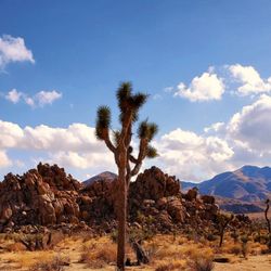
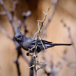
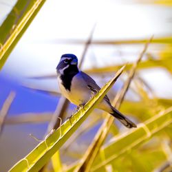
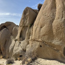
Ryan Mountain Photos


You might also consider
More like Ryan Mountain
Recommended Reviews - Ryan Mountain
Start your review...

Reviews With Photos

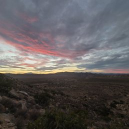
Ryan mountain is dope! It's probably the most traditional "hike" I did in Joshua tree. There's a parking area right at the trailhead, and it took me about 45 minutes to hike to the peak? So not too bad, but I was trying to go fast on purpose (sun was setting) so in theory it could take longer. It starts out with several shallow steps, then turns into more rocky trail terrain. There are some twists and turns but no crazy switchbacks really. I did this hike late in the day (like 6 pm) on purpose to catch the sunset, and I got to the peak around sundown but the sunset along the way was absolutely GORGEOUS. Coming down was a little faster, it's doable in the dark but probably safer to try to stick to doing it in daylight. Of note I came in early April, the high was like 75 and that day was super windy so it actually felt colder. I felt pretty euthermic walking up with my jacket open and just a flannel underneath. There's a sign at the entrance warning about summer heat - if you tried doing this hike in 90-100F weather, you'd had a hard time. Stay hydrated and be careful it attempting that~

Definitely a HARD hike for those on the less fit side. It's basically stair master for 1.5 miles+. The hike is worth it though once you actually get to the top. The views are stunning and you feel like you're on top of the world. I came for the sunrise and it was amazing. We arrived at this location by 4:30 and took an hour to hike up as we waited for the sunrise at around 6:30. If you plan to come in the morning make sure to bring a strong flashlight and good shoes because it is DARK. Worth the trek up if you want a good view or want a good difficult hike.

First hike in Joshua Tree. Awesome views of the distant desert! Total round trip was about 3 miles that takes ~2 hours to complete. Trail was mostly stair-based for the first 1 mile or so. It was a steady incline to the top. No shade. Short video of the hike for those interested: https://www.youtube.com/watch?v=kv7hUPZoja4

First ever hike in Joshua Tree National Park was a pretty popular one in Ryan Mountain Trail. Since we only had time for one hike, we wanted to get a moderately challenging hike in that made us feel like the trip was worth it since we came all the way from L.A. The hike itself is 1.5 miles each way, so 3.0 miles total as it is an out and back trail. Elevation gain is 1,069 feet, which is a decent amount of elevation gain for 1.5 miles. As they said, it was a moderately difficult trail with a steady incline. What surprised me was that the trail was designed with a lot of stair steps rather than a slow incline. Don't expect many flat parts of the trail to catch your breath at all. There are a few spots that you can stop at to catch your breath, but we found that we used those mostly to let people coming from the opposite direction pass us. The summit is nice, the one consistently flat area of the entire trail. Because the overall elevation is 5,456 feet at the summit, you'll get a great view of the park and the surrounding areas. The reward is worth the effort! Parking situation here can be bad. We got here a little before 11 am on a Saturday and the parking lot was already full. We were lucky to snag a parking spot from someone that was leaving as there weren't too many cars waiting for spots. Get here in the afternoon though, good luck getting a spot. Counted at least six cars waiting for spots when we got back to our car at 1 pm. Cell phone reception is nonexistent in the park, but I actually picked up some faint signal while on the hike and was able to connect to Internet. Don't depend on this happening though. You won't need reception to complete this trail as it is heavily trafficked and impossible to get lost. But definitely make sure you know where you are going so you can get in and out of the park. Overall, a good first hike to break in my new National Park Pass. Will want to get here earlier so that we can do two or three hikes next time.


"The...hike up Ryan Mountain is a reaffirmation of life. The pulse accelerates, the senses become more acute, and one may renew the acquaintance of lungs and muscles previously taken for granted." - Joshua Tree National Park: A Visitor's Guide, 1995. Ryan Mountain is one of the most famous trails inside Joshua Tree National Park. It is the second highest point inside the park (after Quail Mountain) at 5,461 feet. ~LOGISTICS~ LOCATION: The mountain itself is located along Park Blvd between Ryan Campground and Sheep Pass Campground. It is also conveniently at the halfway point between the north (Twentynine Palms) and west (Joshua Tree) entrances and the location is signposted, although can be easily missed if you're not paying attention. There is a parking lot at the base of the mountain, which can cause issues during peak season. I went in early January 2021, which technically could be considered peak season but due to COVID and it being a Friday afternoon I didn't have much issue finding parking. For the best chances finding a parking spot it's best to attempt this hike either first thing in the morning or late in the afternoon, which also coincides with the best weather. FACILITIES: There are 1-2 bathroom stalls located at the parking lot - seems like the bathrooms are cleaned semi-regularly as the rangers finished cleaning the bathrooms when I arrived. Keep in mind there's no potable water. DISTANCE: 3 miles out-and-back. Allow 2-3 hours for this hike. DIFFICULTY: NPS rates this as challenging, but many travel and hiking blogs classify the hike as moderate. I am of average fitness and didn't have any issues doing this hike. With that being said though the hike to the summit is only 1.5 miles, there is a 1,050 feet elevation gain. The first half of the elevation gain is marked by various stone steps (think Stairmaster!) but the second half is just paved dirt. Being one of the most popular trails at least all parts of the trail are well maintained. PSA: All parts of the trail are exposed (no shade), so wear plenty of sun protection and *please* don't attempt this during the summer. --- Ever since COVID partly out of necessity I've incorporated hiking into my trips. At least one (ideally a few) hike will be of a moderate/strenuous difficulty as I like to incorporate "a good workout" in my travels (as an excuse to eat well afterwards!). For my JTNP trip Ryan Mountain was my workout hike. Climbing the steps was the hardest part of the trail - at least you can hike this in good sneakers (no traction issues). The summit of the mountain provides a sweeping panoramic view of the park. You can see Mount San Jacinto and Mount San Gorgonio along with Pinto Basin, Lost Horse Valley, Queen Valley, and Pleasant Valley. A pile of rocks marks the summit. It's also a convenient spot should you need to recoup. I definitely consumed at least a few peanut butter pretzels and part of an apple fritter from Jelly Donut along with 2 bottles of water for the hike up. The scenery at the top is gorgeous if you like deserts... but personally I liked the view at Keys View better for a better panoramic view of JTNP. Trail scenery is also okay for flora and fauna - there are better and easier trails for scenic views (Cholla Cactus Garden and Hidden Valley come to mind). As a solo female traveler I felt safe doing this trail as 1) I always passed by large groups of people each way and 2) there's surprisingly good cell reception and GPS at various points of the trail. Because of this experience I have started to become more confident hiking solo for day hikes. Despite its difficulty, I'd definitely consider this hike one of the "must-hikes" of the park if you're up for the challenge.

I rank Ryan Mountain as top 3 of my favorites trails I've ever hiked. I've been to Joshua Tree before, but never went on any hikes there! Went this past weekend and came across the Ryan Mountain trail. This trail was basically stairs all the way up which was fine with me since it reminded me of being on a stair master at the gym lol. Good workout for the bootay heh. The trail curves upward around the mountain, and once you get to the top, you have a breathtaking view of Joshua Tree. If you come visit this park, please make sure to check out this trail if you want to have a blast and get a good workout! Also, don't make the same mistake as I did and not bring enough water because it can get really hot.

This moderate hike is 2.8 round trip, and you climb 1,000 feet. I started it just before 10am, and finished before noon. The time estimate is between 2-3 hours, but with occasional breaks, we made it up in about 50 minutes and the way down was about 35 minutes. Make sure you stretch before, because it's quite a workout. I use the stairmaster at the gym, yet I started feeling the strain this hike had on my knees on my treck back down. I was pretty sore the next day. It was worth it though! It felt very nice to complete the hike, and the weather and views were both great! Make sure to wear sunglasses, sunscreen, and a hat since there is no shade. Also, drink plenty of water!

This was such a tough hike for me as an amateur "wanna be" hiker. Woe to me for not eating prior to the hike so about 1/3 of the way I felt fatigued and dizzy so I had to rest and drink up and eat a protein bar. All was good after that. I made it to the top and it was a nice relaxing payoff to see incredible views of Joshua Tree National Park. Will do it again but will be more prepared physically. You will feel the burn in your legs as you take each step upward. You are going up 1000 feet in 1.5 miles. I will go again but next time I will be prepared and not do it during mid summer and mid day.

Ryan Mountain offers one of the more strenuous hikes in Joshua Tree park. It's about 1,000 feet of elevation gain in 1.5 miles, which worked out to be about 45 minutes of the stair master for us. Nature's stair master is what this hike is. After taking a break at the top, it was another 35 minutes back down. Great work out, gets your blood pumping, but I feel like the best views were seen on the drive here. The whimsical Joshua trees and Flinstone's-esque rock formations look pretty much like dirt from the this high up. But from here you can see a vast portion of the valley and rolling hills. Also, the breeze feels amazing after that hike. Take it all in. You deserve it!

A 3.0 mile hike up to the beautiful 360 views on Ryan Mountain. Elevation came in at 5,457 feet. The hike is a steady incline along a narrow trail. It was super windy and cold on 03/05/17 so we made sure to bundle up. Also worthy of noting there is no shade so do yourself a favor and wear a hat and sunscreen. The hike is very self rewarding and you will feel enlighten when you have completed it. I love the information booth we saw at the beginning of the hike. I mostly enjoyed and appreciated that the trail is well maintained. I would categorize this as a moderate hike.
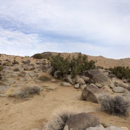
Activity Type: Hiking Nearby City: Twentynine Palms Length: 3.2 total miles Elevation Gain: 1,066 feet Trail Type: Out-and-back Skill Level: Moderately strenuous Duration: 1.5 hours Season: Best mid-September through mid-May Trailhead Elevation: 4,391 feet Top Elevation: 5,457 feet Local Contacts: Joshua Tree National Park This excellent trail leads to a high, isolated mountain in the west-central area of the park. Expansive vistas open up across much of Joshua Tree and the surrounding desert. Ryan Mountain, one of the highest peaks in Joshua Tree National Park, is an isolated massif rising between the broad, Joshua tree-covered flats of Lost Horse Valley to the west and Queen Valley to the east. Its open summit and isolated location affords panoramic views of much of the park, including the Queen and Little San Bernardino Mountains and the rockbound landscape of the Wonderland of Rocks. The hike follows one of the best constructed trails in Joshua Tree, though it does rise at a steady, moderate grade. It's an enjoyable hike from autumn through spring, but the mountain is often swept by strong winds. Winter is an ideal time to hike here, when the desert air is clear and vistas stretch to far horizons.

Ryan Trailhead is another stop within Joshua Tree National Park and a must do. The starting point for the 3-mile roundtrip hike to the summit of Ryan Mountain. There is a steep uphill climb that will provide scenic views, good exercise, and different terrain. There is plenty of parking, access to restrooms, and an educational section, where you'll learn about how the natives used to live and survive. read more


Popular high hike of JT National Park. Not the tallest, but some of the best views of this desert. From the large parking lot, you'll hike along the very well-defined trail up stone stairs for over an hour. Patiently, you'll eventually reach the summit and enjoy exhilarating views of Joshua Tree, including squints of JT's popular hiking trails and the tall Quail Mountain. Highly recommended. Quiet, peaceful ambience. read more


 in the distance. - Hiking Near Me - Twentynine Palms, California")

Ryan Mountain is a 3 mile hike in Joshua Tree National Park and probably one of the most popular attractions in the park. It has more than 1,000 feet of elevation gain in 1.5 miles which means it's pretty much straight incline the entire time. There are plenty of stairs and trails on the edge so be careful of where you're walking. At the top you'll find beautiful views of the park and it's a huge reward for the effort. I'd recommend coming early because the parking spots fill up fast. There's not much shade throughout the hike so bring plenty of water and take breaks if needed. read more


1 year ago
Ryan mountain is dope! It's probably the most traditional "hike" I did in Joshua tree. There's a parking area right at the trailhead, and it took me about 45 minutes to hike to the peak? So not too bad, but I was trying to go fast on purpose (sun was setting) so in theory it could take longer. It starts out with several shallow steps, then turns into more rocky trail terrain. There are some twists and turns but no crazy switchbacks really. I did this hike late in the day (like 6 pm) on purpose to catch the sunset, and I got to the peak around sundown but the sunset along the way was absolutely GORGEOUS. Coming down was a little faster, it's doable in the dark but probably safer to try to stick to doing it in daylight. Of note I came in early April, the high was like 75 and that day was super windy so it actually felt colder. I felt pretty euthermic walking up with my jacket open and just a flannel underneath. There's a sign at the entrance warning about summer heat - if you tried doing this hike in 90-100F weather, you'd had a hard time. Stay hydrated and be careful it attempting that~ read more


Definitely a HARD hike for those on the less fit side. It's basically stair master for 1.5 miles+. The hike is worth it though once you actually get to the top. The views are stunning and you feel like you're on top of the world. I came for the sunrise and it was amazing. We arrived at this location by 4:30 and took an hour to hike up as we waited for the sunrise at around 6:30. If you plan to come in the morning make sure to bring a strong flashlight and good shoes because it is DARK. Worth the trek up if you want a good view or want a good difficult hike. read more

First hike in Joshua Tree. Awesome views of the distant desert! Total round trip was about 3 miles that takes ~2 hours to complete. Trail was mostly stair-based for the first 1 mile or so. It was a steady incline to the top. No shade. Short video of the hike for those interested: https://www.youtube.com/watch?v=kv7hUPZoja4 read more


4 years ago
5 years ago
First ever hike in Joshua Tree National Park was a pretty popular one in Ryan Mountain Trail. Since we only had time for one hike, we wanted to get a moderately challenging hike in that made us feel like the trip was worth it since we came all the way from L.A. The hike itself is 1.5 miles each way, so 3.0 miles total as it is an out and back trail. Elevation gain is 1,069 feet, which is a decent amount of elevation gain for 1.5 miles. As they said, it was a moderately difficult trail with a steady incline. What surprised me was that the trail was designed with a lot of stair steps rather than a slow incline. Don't expect many flat parts of the trail to catch your breath at all. There are a few spots that you can stop at to catch your breath, but we found that we used those mostly to let people coming from the opposite direction pass us. The summit is nice, the one consistently flat area of the entire trail. Because the overall elevation is 5,456 feet at the summit, you'll get a great view of the park and the surrounding areas. The reward is worth the effort! Parking situation here can be bad. We got here a little before 11 am on a Saturday and the parking lot was already full. We were lucky to snag a parking spot from someone that was leaving as there weren't too many cars waiting for spots. Get here in the afternoon though, good luck getting a spot. Counted at least six cars waiting for spots when we got back to our car at 1 pm. Cell phone reception is nonexistent in the park, but I actually picked up some faint signal while on the hike and was able to connect to Internet. Don't depend on this happening though. You won't need reception to complete this trail as it is heavily trafficked and impossible to get lost. But definitely make sure you know where you are going so you can get in and out of the park. Overall, a good first hike to break in my new National Park Pass. Will want to get here earlier so that we can do two or three hikes next time. read more


5 years ago
"The...hike up Ryan Mountain is a reaffirmation of life. The pulse accelerates, the senses become more acute, and one may renew the acquaintance of lungs and muscles previously taken for granted." - Joshua Tree National Park: A Visitor's Guide, 1995. Ryan Mountain is one of the most famous trails inside Joshua Tree National Park. It is the second highest point inside the park (after Quail Mountain) at 5,461 feet. ~LOGISTICS~ LOCATION: The mountain itself is located along Park Blvd between Ryan Campground and Sheep Pass Campground. It is also conveniently at the halfway point between the north (Twentynine Palms) and west (Joshua Tree) entrances and the location is signposted, although can be easily missed if you're not paying attention. There is a parking lot at the base of the mountain, which can cause issues during peak season. I went in early January 2021, which technically could be considered peak season but due to COVID and it being a Friday afternoon I didn't have much issue finding parking. For the best chances finding a parking spot it's best to attempt this hike either first thing in the morning or late in the afternoon, which also coincides with the best weather. FACILITIES: There are 1-2 bathroom stalls located at the parking lot - seems like the bathrooms are cleaned semi-regularly as the rangers finished cleaning the bathrooms when I arrived. Keep in mind there's no potable water. DISTANCE: 3 miles out-and-back. Allow 2-3 hours for this hike. DIFFICULTY: NPS rates this as challenging, but many travel and hiking blogs classify the hike as moderate. I am of average fitness and didn't have any issues doing this hike. With that being said though the hike to the summit is only 1.5 miles, there is a 1,050 feet elevation gain. The first half of the elevation gain is marked by various stone steps (think Stairmaster!) but the second half is just paved dirt. Being one of the most popular trails at least all parts of the trail are well maintained. PSA: All parts of the trail are exposed (no shade), so wear plenty of sun protection and *please* don't attempt this during the summer. --- Ever since COVID partly out of necessity I've incorporated hiking into my trips. At least one (ideally a few) hike will be of a moderate/strenuous difficulty as I like to incorporate "a good workout" in my travels (as an excuse to eat well afterwards!). For my JTNP trip Ryan Mountain was my workout hike. Climbing the steps was the hardest part of the trail - at least you can hike this in good sneakers (no traction issues). The summit of the mountain provides a sweeping panoramic view of the park. You can see Mount San Jacinto and Mount San Gorgonio along with Pinto Basin, Lost Horse Valley, Queen Valley, and Pleasant Valley. A pile of rocks marks the summit. It's also a convenient spot should you need to recoup. I definitely consumed at least a few peanut butter pretzels and part of an apple fritter from Jelly Donut along with 2 bottles of water for the hike up. The scenery at the top is gorgeous if you like deserts... but personally I liked the view at Keys View better for a better panoramic view of JTNP. Trail scenery is also okay for flora and fauna - there are better and easier trails for scenic views (Cholla Cactus Garden and Hidden Valley come to mind). As a solo female traveler I felt safe doing this trail as 1) I always passed by large groups of people each way and 2) there's surprisingly good cell reception and GPS at various points of the trail. Because of this experience I have started to become more confident hiking solo for day hikes. Despite its difficulty, I'd definitely consider this hike one of the "must-hikes" of the park if you're up for the challenge. read more


5 years ago
I rank Ryan Mountain as top 3 of my favorites trails I've ever hiked. I've been to Joshua Tree before, but never went on any hikes there! Went this past weekend and came across the Ryan Mountain trail. This trail was basically stairs all the way up which was fine with me since it reminded me of being on a stair master at the gym lol. Good workout for the bootay heh. The trail curves upward around the mountain, and once you get to the top, you have a breathtaking view of Joshua Tree. If you come visit this park, please make sure to check out this trail if you want to have a blast and get a good workout! Also, don't make the same mistake as I did and not bring enough water because it can get really hot. read more


This moderate hike is 2.8 round trip, and you climb 1,000 feet. I started it just before 10am, and finished before noon. The time estimate is between 2-3 hours, but with occasional breaks, we made it up in about 50 minutes and the way down was about 35 minutes. Make sure you stretch before, because it's quite a workout. I use the stairmaster at the gym, yet I started feeling the strain this hike had on my knees on my treck back down. I was pretty sore the next day. It was worth it though! It felt very nice to complete the hike, and the weather and views were both great! Make sure to wear sunglasses, sunscreen, and a hat since there is no shade. Also, drink plenty of water! read more


This was such a tough hike for me as an amateur "wanna be" hiker. Woe to me for not eating prior to the hike so about 1/3 of the way I felt fatigued and dizzy so I had to rest and drink up and eat a protein bar. All was good after that. I made it to the top and it was a nice relaxing payoff to see incredible views of Joshua Tree National Park. Will do it again but will be more prepared physically. You will feel the burn in your legs as you take each step upward. You are going up 1000 feet in 1.5 miles. I will go again but next time I will be prepared and not do it during mid summer and mid day. read more


Ryan Mountain offers one of the more strenuous hikes in Joshua Tree park. It's about 1,000 feet of elevation gain in 1.5 miles, which worked out to be about 45 minutes of the stair master for us. Nature's stair master is what this hike is. After taking a break at the top, it was another 35 minutes back down. Great work out, gets your blood pumping, but I feel like the best views were seen on the drive here. The whimsical Joshua trees and Flinstone's-esque rock formations look pretty much like dirt from the this high up. But from here you can see a vast portion of the valley and rolling hills. Also, the breeze feels amazing after that hike. Take it all in. You deserve it! read more


A 3.0 mile hike up to the beautiful 360 views on Ryan Mountain. Elevation came in at 5,457 feet. The hike is a steady incline along a narrow trail. It was super windy and cold on 03/05/17 so we made sure to bundle up. Also worthy of noting there is no shade so do yourself a favor and wear a hat and sunscreen. The hike is very self rewarding and you will feel enlighten when you have completed it. I love the information booth we saw at the beginning of the hike. I mostly enjoyed and appreciated that the trail is well maintained. I would categorize this as a moderate hike. read more


Activity Type: Hiking Nearby City: Twentynine Palms Length: 3.2 total miles Elevation Gain: 1,066 feet Trail Type: Out-and-back Skill Level: Moderately strenuous Duration: 1.5 hours Season: Best mid-September through mid-May Trailhead Elevation: 4,391 feet Top Elevation: 5,457 feet Local Contacts: Joshua Tree National Park This excellent trail leads to a high, isolated mountain in the west-central area of the park. Expansive vistas open up across much of Joshua Tree and the surrounding desert. Ryan Mountain, one of the highest peaks in Joshua Tree National Park, is an isolated massif rising between the broad, Joshua tree-covered flats of Lost Horse Valley to the west and Queen Valley to the east. Its open summit and isolated location affords panoramic views of much of the park, including the Queen and Little San Bernardino Mountains and the rockbound landscape of the Wonderland of Rocks. The hike follows one of the best constructed trails in Joshua Tree, though it does rise at a steady, moderate grade. It's an enjoyable hike from autumn through spring, but the mountain is often swept by strong winds. Winter is an ideal time to hike here, when the desert air is clear and vistas stretch to far horizons. read more


5 years ago
6 years ago
Ryan Mountain Trail,located in Joshua Tree National Park in Southern California is a terrific half day hike to one of them any scenic trail hikes in Joshua Tree National Park! They have a large parking area for cars,trucks,RVs,motorcycles, and bicycles. Ryan Mountain is a scenic hike that people young and old enjoy! It takes you to see cactus,shrubs,interesting hills and mountain scenery. The trail along the way,which is well marked,has stone steps cut by The Works Projects Administration(WPA)in the 1930's and has been helping hundreds of thousands of happy hikers over the years enjoy Ryan Mountain Trail. You will usually be accompanied throughout the hike with other hikers enjoying the scenic Joshua Tree National Park scenery. Safe for young and old! It'll take you about an hour to reach the peak plateau area-but no rush enjoy the sites on the way up! Bring water with you and your camera or mobile phone for incredible, 'grammable pix! Joshua Tree National Park,located in the scenic,beautiful and historical Southern California desert community of Joshua Tree,is a world class travel and outdoor destination that is a MUST SEE visitors experience! From the beautiful and healthy desert sun and air to the fantastic rock formations and clear nite time star filled desert skys,Joshua Tree National Park is a magnificent not to be missed destination! The JTNP is perfect for a half day "drive through",a full day "stop and go"picture filled ,totally "grammable" excursion or a camp over for the full nite time stars experience! There's lots to do at JTNP from short hikes to longer overnite hikes! . . . . . #ryanmountaintrail #ryanpeak #hikeryan #iloveryanmountaintrail #joshuatree #californiadreamin #californiadreaming #joshuatreenationalpark #starrynights #bigdipper #jtnp #joshuatreebubblehouse #joshuatreebubbletent #waynesalvatti #photografxworldwide #ilovejt #ilovejoshuatree #jthvn @jthvn #desert #californiadesert #ilovejoshuatree #visitjoshuatree #climbjt #rockclimbing #hiking #getoutthere #goclimbjoshuatree #californiadeserts #seejt #photography #outdoorphotography #godisgood #wildflowers #desertflowers #desertblooms read more


Beautiful views of the whole park as you wind your way to the top. It's labeled as strenuous, but I think they're being fairly conservative... though it probably depends a lot on the heat. Temperature was in the low 70s so I found this hike to be pretty moderate and we had energy to take on another one right after. The ranger said there would be a big temperature difference of up to 20 degrees from bottom to top, but it was consistent the whole way through. read more

8 years ago
What a great hike! I did this yesterday and it was absolutely beautiful, albeit very very cold. The weather was sunny and clear in the low 40s at the bottom of the trail but once we ascended, the temperature started dropping. It was snowing at the top. The hike itself is 3miles round trip and labeled as strenuous, but I didn't think it was too bad (for reference, I hike once a week and do a few cardio workouts a week as well). It could be a little more difficult for someone not accustomed to working out. The first 1.5 miles or so is completely uphill and then the way back is all downhill. The views at the top were beautiful, though it was snowing so visibility was limited for us. If going at this time of the year (mid January) I recommend bringing gloves, a hat, warm jacket, hiking boots and lots of water. I enjoyed this trail and I'm excited to do it again in the spring when it's not so cold. read more


It was my first day at Joshua Tree and the hikes that I had gone on so far were fairly light. Ryan mountain said strenuous on the park guide, so I decided to try it in the middle of the day. Took about 2.5 hours to complete, got some decent exercise. The annoying thing was that there were bugs flying around. Fortunately it wasn't too hot that day. After I finished, I realized that my legs were sore for the rest of the day. read more


8 years ago
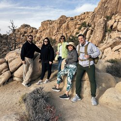
This was a wonderful hike for several reasons. On our recent first trip to Joshua Tree, my friends and I were eager to take in the park's gorgeous surroundings while breaking a sweat at some point in the day. Ryan Mountain is the perfect hike for both goals. The apex of the park (5545 feet) offers a panoramic view of Joshua Tree. You will, however, have to work for this view. The ascent was rigorous and invigorating and can entirely be taken at your own place (which made it perfect for our group of 8 hikers). Whether you want to push yourself and quickly ascend to the top or take in your surroundings at a more leisurely pace, this hike is perfect for both. It can be very windy at the top though so I recommend layering up (also parking can be quite difficult so be ready to wait it out in the small parking lot or drive farther down the street and walk back for the hike). read more


Good hike to see the sunrise or sunset. Moderately strenuous less than 3 mile roundtrip hike - it took us about 1.5 hours at a leisurely pace. About 330 meter or 1,000 feet elevation gain and wonderful views! We went in late April after all the rains of 2017 and there were still tons of wildflowers! The wind also made it a lot chillier than we anticipated - so rung layers! The hike was also pretty well maintained. read more


9 years ago
10 years ago
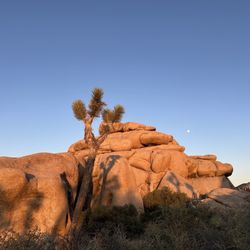
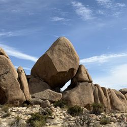
I hiked Ryan Mountain with my husband while we were camping in Joshua Tree this past February. I tried hiking Ryan 5 years ago and couldn't complete it because of the heat! I would suggest camping/hiking in Joshua Tree during the winter. Although it's cold at night it's much easier to hike during the day with cooler temperatures. With that said Ryan Mountain is a bit of a trek! Bring lots of water and good hiking shoes. It's almost 3 miles with about a 1,000 ft gain. The trail is well maintained albeit a bit rocky. When you finally reach the top there is a rewarding 360 view of the entire national park. There's also a giant pile of rocks that makes for some iconic photos! read more


5 years ago
11 years ago
My hubby and I went with some friends this morning to hike Ryan Mountain in Joshua Tree National Park and I am so happy the Ranger at the visitor center told us all about this hike because it was absolutely stunning and beautiful!! The way up has lots of steps had to take a couple breaks but the scenery is incredible the whole way up!! We got a ton of wonderful photos so extremely happy we hiked Ryan Mountain!! read more


9 years ago
13 years ago
More info about Ryan Mountain
49 Palms Oasis
Twentynine Palms, CA 92277
Directions
(760) 367-5500
Call Now
Hours
Outdoor Amenities
Ask the Community - Ryan Mountain
Review Highlights - Ryan Mountain
You might also consider


Ryan Mountain - hiking - Updated July 2026
Best of Twentynine Palms
People found Ryan Mountain by searching for…
Campgrounds in Twentynine Palms, California
Watch Sunset in Twentynine Palms, California
Scenic Drive in Twentynine Palms, California
Visitor Centers in Twentynine Palms, California
Stairs Workout in Twentynine Palms, California
Things to Do in Twentynine Palms, California
Night Hike in Twentynine Palms, California
Things to Do on a Rainy Day in Twentynine Palms, California
Hiking Trails With Waterfalls in Twentynine Palms, California
Parks in Twentynine Palms, California
Hiking With Kids in Twentynine Palms, California
Sunrise View in Twentynine Palms, California
Scenic Night View in Twentynine Palms, California
Photo Spots in Twentynine Palms, California
Sunset View in Twentynine Palms, California
Things to Do at Night in Twentynine Palms, California
Scenic Overlook in Twentynine Palms, California
Camping Sites in Twentynine Palms, California
Natural Hot Springs in Twentynine Palms, California
Stargazing in Twentynine Palms, California
Beautiful Views in Twentynine Palms, California
Secret Spots in Twentynine Palms, California
Browse Articles
Browse Nearby
Browse Brands
Trending Searches in Twentynine Palms, CA
Black Owned Nail Salons in Twentynine Palms, CA
Boat Rental in Twentynine Palms, CA
Cliff Jumping in Twentynine Palms, CA
Day Trips in Twentynine Palms, CA
Fireworks in Twentynine Palms, CA
Jet Ski Rental in Twentynine Palms, CA
Lakes & Ponds in Twentynine Palms, CA
Off Road Trails in Twentynine Palms, CA
Outdoor Activities in Twentynine Palms, CA
Pool Day Pass in Twentynine Palms, CA
Public Pools in Twentynine Palms, CA
Public Shower in Twentynine Palms, CA
River Swimming in Twentynine Palms, CA
River Tubing in Twentynine Palms, CA
Rock Quarry in Twentynine Palms, CA
Running Trails in Twentynine Palms, CA
Scenic Overlook in Twentynine Palms, CA
Splash Pad in Twentynine Palms, CA
Strawberry Picking in Twentynine Palms, CA
Sunrise View in Twentynine Palms, CA
Swimming Holes in Twentynine Palms, CA
Swimming Lakes in Twentynine Palms, CA
Watch Sunset in Twentynine Palms, CA