Ridgeview Park Photos


More like Ridgeview Park
Recommended Reviews - Ridgeview Park
Start your review...

11 years ago
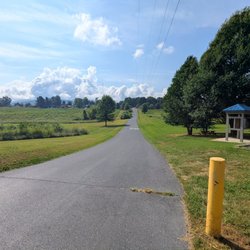
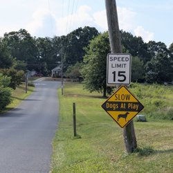
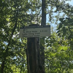
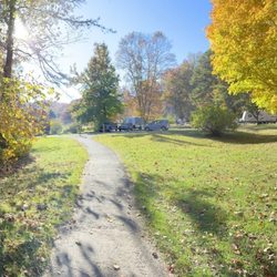
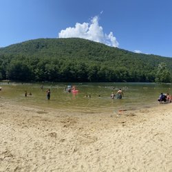
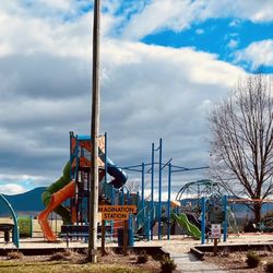
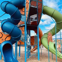
I can't believe that this amazing park has never been added to Yelp before. Ridgeview Park (RP) is 85-acres full of wonderful amenities. When I climbed out of my van the other day, all I could see was green everywhere. Kids could run around the grassy fields forever and not get bored. The hills were extremely tempting to my youngest son who had to run up them and then roll down. Beautiful trees, lovely flowers, a gorgeous view of the mountains--but the best part was the river. You are able to walk up to the water's edge and play with the rocks. Here are some features: * Amphitheater * Baseball/Softball Diamond * Basketball Court * Soccer Field * Tennis Courts * Trails (there are supposed to be trails in the woods, but I didn't get a chance to check them out) * Playground * Picnic tables and grills * Restrooms * Serenity Garden * Swimming Pool * Fishing in the South River throughout the park (trout, bass, perch, bluegill, and catfish) * Handicap-Accessible Fishing Pier I was here for vacation and I always try to look for parks. I found RP online and it was way better than I ever imagined it would be. In fact, I kind of started to fall in love with it and Waynesboro. My boys and I greatly enjoyed our short time at RP and I highly recommend you visit. I wish RP was closer to my house. read more


Beautiful park! Came out to explore the area a bit and we had a great time on the nice playgrounds right along the river, seeing the geese, walking the foot bridge and running around in the wide open fields. Great way for the kids to get out their energy! read more


9 years ago
More info about Ridgeview Park


Ridgeview Park - parks - Updated July 2026
Best of Waynesboro
People found Ridgeview Park by searching for…
Fishing in Waynesboro, Virginia
Things to Do in Waynesboro, Virginia
Hiking in Waynesboro, Virginia
Playgrounds in Waynesboro, Virginia
River Swimming in Waynesboro, Virginia
Basketball Courts in Waynesboro, Virginia
Flower Fields in Waynesboro, Virginia
Hiking Trails With Waterfalls in Waynesboro, Virginia
Tennis in Waynesboro, Virginia
Running Trails in Waynesboro, Virginia
Places to Take Pictures in Waynesboro, Virginia
Beautiful Views in Waynesboro, Virginia
Parks for Kids in Waynesboro, Virginia
Walking Trails in Waynesboro, Virginia
Watch Sunset in Waynesboro, Virginia
Splash Pad in Waynesboro, Virginia
Cherry Blossoms in Waynesboro, Virginia
Jungle Gym in Waynesboro, Virginia
Bird Watching in Waynesboro, Virginia
Star Gazing in Waynesboro, Virginia
Free Parking in Waynesboro, Virginia
Kids Birthday in Waynesboro, Virginia
Trending Searches in Waynesboro, VA
Cliff Jumping in Waynesboro, VA
Dog Swimming in Waynesboro, VA
Fishing Spots in Waynesboro, VA
Jet Ski Rental in Waynesboro, VA
Kayak Rental in Waynesboro, VA
Kids Activities Outdoor in Waynesboro, VA
Lookout Points in Waynesboro, VA
Outdoor Basketball Courts in Waynesboro, VA
Picnic Areas in Waynesboro, VA
Pool Day Pass in Waynesboro, VA
Public Pools in Waynesboro, VA
River Swimming in Waynesboro, VA
River Tubing in Waynesboro, VA
Scenic Overlook in Waynesboro, VA
Soccer Store in Waynesboro, VA
Strawberry Picking in Waynesboro, VA
Swimming Holes in Waynesboro, VA
Browse Articles
Browse Nearby
BEST of Waynesboro, Virginia Restaurants near Ridgeview Park
BEST of Waynesboro, Virginia Playgrounds near Ridgeview Park
BEST of Waynesboro, Virginia Walking Trails near Ridgeview Park
BEST of Waynesboro, Virginia Coffee near Ridgeview Park
BEST of Waynesboro, Virginia Things to Do near Ridgeview Park
BEST of Waynesboro, Virginia Breakfast near Ridgeview Park
BEST of Waynesboro, Virginia Star Gazing near Ridgeview Park
BEST of Waynesboro, Virginia Campgrounds near Ridgeview Park
Browse Brands
Related Searches in Waynesboro, VA
Best Off Leash Dog Parks in Waynesboro, Virginia
Best Water Parks for Kids in Waynesboro, Virginia
Check Out Great Playgrounds in Waynesboro, Virginia
Discover Baseball Fields Around Waynesboro, Virginia
Discover Free Parking Options in Waynesboro, Virginia
Discover Fun Activities to Do in Waynesboro, Virginia
Discover Fun Toddler Parks in Waynesboro, Virginia for Your Little One
Discover Popular Photo Spots in Waynesboro, Virginia
Discover Top Nature Parks to Visit in Waynesboro, Virginia
Discover Walking Parks in Waynesboro, Virginia Near You
Discover the Best Beaches in Waynesboro, Virginia
Enjoy the Best Picnic Spots and Ideas in Waynesboro, Virginia
Enjoy the Best Walking Trails in Waynesboro, Virginia
Explore Family-Friendly Zoos and Wildlife in Waynesboro, Virginia
Explore Free Picnic Areas Around Waynesboro, Virginia
Explore Fun Activities to Do in Waynesboro, Virginia
Explore Popular Campgrounds Near Waynesboro, Virginia
Explore Popular Picnic Areas Around Waynesboro, Virginia
Explore Popular RV Parks Around Waynesboro, Virginia
Explore Popular Recreation Centers Around Waynesboro, Virginia
Explore Popular Scenic Views Near Waynesboro, Virginia
Explore Popular View Points Around Waynesboro, Virginia
Explore Scenic Lakes to Visit in Waynesboro, Virginia
Explore Secret Spots Worth Visiting in Waynesboro, Virginia
Explore Top Dog Parks in Waynesboro, Virginia Near You
Explore Top Gyms in Waynesboro, Virginia Now
Explore Top Water Parks in Waynesboro, Virginia Today
Explore the Best Swimming Holes Around Waynesboro, Virginia
Find Beautiful Views in Waynesboro, Virginia
Find Picnic Tables for Outdoor Fun in Waynesboro, Virginia
Find Top Skate Parks in Waynesboro, Virginia for All Skill Levels
Find the Best Parks for Picnics in Waynesboro, Virginia
Find the Best Swimming Pools in Waynesboro, Virginia Today
Fun Things for Kids in Waynesboro, Virginia
Have Fun at a Splash Pad in Waynesboro, Virginia
Locate Tennis Courts Around Waynesboro, Virginia
Must-See Tourist Attractions Around Waynesboro, Virginia
Parks With Basketball Courts for Games in Waynesboro, Virginia
Picnic Areas With BBQ Pits Available in Waynesboro, Virginia
Popular Fishing Spots to Explore in Waynesboro, Virginia
Popular Kids Activities in Waynesboro, Virginia
Popular Outdoor Activities to Try in Waynesboro, Virginia
Popular Things to Do in Waynesboro, Virginia
Popular Things to See in Waynesboro, Virginia
Top Hiking Trails to Explore in Waynesboro, Virginia
Top Running Trails to Explore in Waynesboro, Virginia
Top Swimming Lakes to Enjoy in Waynesboro, Virginia
Top-Rated Basketball Courts to Play at in Waynesboro, Virginia