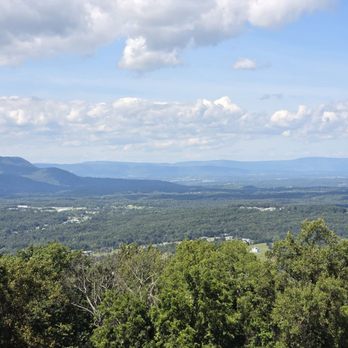
Blue Ridge Parkway Photos


More like Blue Ridge Parkway
Recommended Reviews - Blue Ridge Parkway
Start your review...


Reviews With Photos


The Blue Ridge Parkway is one of the most visited National Parks, 469 miles of twisty road from Waynesboro, VA to Cherokee, NC. It's a gorgeous drive or bicycle ride, with a lot of elevation changes and tons of pretty vistas. There are numerous visitor centers along the way to stop and rest, and if you like this type of drive, you will be rewarded with an interesting drive. It's also a springboard to many hiking opportunities, with numerous trail heads along the road. It's beautiful at any time of the year, from the colorful autumn colors to the burst of wildflowers in spring, to the icy beauty in the winter, and the cooler temperatures in the summer. An awesome drive!


I hadn't been here since I was a kid. It was an amazing drive and the scenery was magnificent. We were originally going to take 81 down to TN, but decided that since we didn't have anywhere to be today before check in at the hotel, we would go this way for awhile. It is a great break from the interstate and the typical road hypnosis you get on 81. The trails are a nice break and give you a little workout. The visitor center on the north end that we stopped at was cozy and the staff member was very helpful and informative. I can't wait to drive the other couple hundred miles the next time we get down here.


I was honestly expecting more. The road's in pretty bad shape in parts. I did the entire length in 3 days, and preferred the VA side. The NC side has more elevation and is certainly more scenic because of it (parts are breathtaking) , VA more "civilized". Has good hiking trails throughout. Speeds can get challenging for the timid driver. Wiser to pull over and let the speed demons pass. Hogging the road is not a great idea here. VA speeds much easier to maintain. It's gorgeous, but watch the potholes. Personally, I prefer Skyline Drive. I went October 17-20, great time for a midweight touch of color; not yet full-blast. In hindsight, would be smarter to go North to South. Leaves change at a different time each year - was just really warm; I hear last year they were gone much earlier. Glassmine Falls were not falling - I guess they dried up as there wasn't any rain. I was looking forward to this drive very much - perhaps overexcited a touch? I'm happy I did it, but am unlikely to do it again. As opposed to Skyline Drive, which I do several times a year. Then again, maybe it was just mountain overload. It gets repetitive; and I often found myself going on out of pure stubbornness - I said I'd do it and I'll do it. Perhaps a more flexible approach would make it more enjoyable. Star removed for the potholes. Some of them are BAD, and that's not good on a mountain road. Just sayin'. Go mid-week if you can. Weekends are crazy.

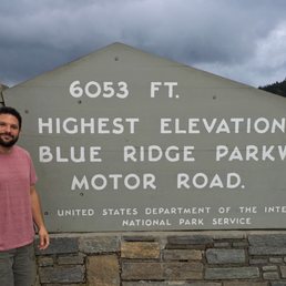

Shenandoah National Park is beautiful. There is a lot of history here and I recommend doing a bit of reading before arriving. Or not. You will enjoy it either way. Skyline drive was a CCC project that ran from 1933 - 1941 and it is clear they did an excellent job. All those stone walls, all over the park, are hand crafted by CCC. Besides the 105 miles of paved road and multiple scenic over looks, there are many, many trails leading into the wilderness. Some are easier, others for a more advanced hiker. Cabins, campgrounds, a gas station, gift shops, restaurants, ev charge station and public restrooms are dotted along the road. You can spend a day, or a week, soaking in the Blue Ridge Mountains. read more

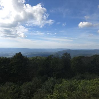


The Blue Ridge Parkway begins where Skyline Drive ends in Shenandoah National Park, Virginia. It runs 217 miles from Anton to the border with North Carolina near Roanoke, before continuing farther to the southwest into the Smoky Mountains in far western Carolina; 469 miles in all. It is very similar to Skyline Drive, but offers somewhat higher peaks and and more astounding long vistas of blue tinged valleys from overlooks along the route. Still, if you love this part of the Appalachians, you really owed it to yourself to continue the excursion at least partially down the twisting crest hugging blacktop for as long as you wish. We were able to do more rock scrambling there than farther north, and the adventure quotient was that much more challenging. Too, we had a decent map of the secondary roads, and turned off the Parkway to return via unpaved single lane gravel tracks that took us deeper into the vales and hollows where the locals live and work the land. I imaged hearing banjo and bluegrass as we passed crystal flowing streams and cascading boulder diverted waterfalls. Perfect soundtrack to our personal travelogue. Those fifty miles were the most exciting. At first a little nervous being somewhere we might not be found, we gradually found some confidence as our car trekked the forest road well, and the one pickup we met along the way courteously pulled out of our way to let us pass, with a smile and wave. Pennsylvania has the Allegheny Mountains, the northern continuation of the Blue Ridge. They are rugged and beautiful in their own right, but lack the focus demanded from a challenging drive on mountain roads dedicated to letting travelers discover their intense magnetism. Spend enough time under their spell and you will swear you underwent a near religious experience. read more


7 years ago
The Blue Ridge Parkway is one of the most visited National Parks, 469 miles of twisty road from Waynesboro, VA to Cherokee, NC. It's a gorgeous drive or bicycle ride, with a lot of elevation changes and tons of pretty vistas. There are numerous visitor centers along the way to stop and rest, and if you like this type of drive, you will be rewarded with an interesting drive. It's also a springboard to many hiking opportunities, with numerous trail heads along the road. It's beautiful at any time of the year, from the colorful autumn colors to the burst of wildflowers in spring, to the icy beauty in the winter, and the cooler temperatures in the summer. An awesome drive! read more


6 years ago

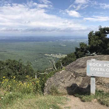
I hadn't been here since I was a kid. It was an amazing drive and the scenery was magnificent. We were originally going to take 81 down to TN, but decided that since we didn't have anywhere to be today before check in at the hotel, we would go this way for awhile. It is a great break from the interstate and the typical road hypnosis you get on 81. The trails are a nice break and give you a little workout. The visitor center on the north end that we stopped at was cozy and the staff member was very helpful and informative. I can't wait to drive the other couple hundred miles the next time we get down here. read more




10 years ago
I was honestly expecting more. The road's in pretty bad shape in parts. I did the entire length in 3 days, and preferred the VA side. The NC side has more elevation and is certainly more scenic because of it (parts are breathtaking) , VA more "civilized". Has good hiking trails throughout. Speeds can get challenging for the timid driver. Wiser to pull over and let the speed demons pass. Hogging the road is not a great idea here. VA speeds much easier to maintain. It's gorgeous, but watch the potholes. Personally, I prefer Skyline Drive. I went October 17-20, great time for a midweight touch of color; not yet full-blast. In hindsight, would be smarter to go North to South. Leaves change at a different time each year - was just really warm; I hear last year they were gone much earlier. Glassmine Falls were not falling - I guess they dried up as there wasn't any rain. I was looking forward to this drive very much - perhaps overexcited a touch? I'm happy I did it, but am unlikely to do it again. As opposed to Skyline Drive, which I do several times a year. Then again, maybe it was just mountain overload. It gets repetitive; and I often found myself going on out of pure stubbornness - I said I'd do it and I'll do it. Perhaps a more flexible approach would make it more enjoyable. Star removed for the potholes. Some of them are BAD, and that's not good on a mountain road. Just sayin'. Go mid-week if you can. Weekends are crazy. read more


7 years ago
The Blue ridge parkway in Waynesboro, Virginia is a beautiful place to visit . The light breeze and the scent of nature makes it even more appealing. If you appreciate nature and beautiful views , then you will enjoy the blue ridge parkway. read more


12 years ago

10 years ago
an amazing landscape of winding road mixed with nature set thousands of feet above sea level read more
More info about Blue Ridge Parkway
Waynesboro, VA 22980
Directions
Visit Website
https://www.nps.gov/blri/
Hours
Outdoor Amenities
Ask the Community - Blue Ridge Parkway
Review Highlights - Blue Ridge Parkway











Blue Ridge Parkway - parks - Updated October 2026
Best of Waynesboro
People found Blue Ridge Parkway by searching for…
Things to Do in Waynesboro, VA
Scenic Drive in Waynesboro, VA
Hiking Trails With Waterfalls in Waynesboro, VA
Scenic Overlook in Waynesboro, VA
River Swimming in Waynesboro, VA
Watch Sunset in Waynesboro, VA
Beautiful Views in Waynesboro, VA
Places to Take Pictures in Waynesboro, VA
Picnic Spots in Waynesboro, VA
Lookout Points in Waynesboro, VA
Running Trails in Waynesboro, VA
Off Road Trails in Waynesboro, VA
Parks for Picnics in Waynesboro, VA
Abandoned Buildings in Waynesboro, VA
Free Swimming Pool in Waynesboro, VA
Sculpture Park in Waynesboro, VA
Trending Searches in Waynesboro, VA
Apple Orchards near Blue Ridge Parkway
Apple Picking near Blue Ridge Parkway
Baseball Fields near Blue Ridge Parkway
Corn Maze near Blue Ridge Parkway
Costume Store near Blue Ridge Parkway
Craft Fairs near Blue Ridge Parkway
Dog Parks near Blue Ridge Parkway
Hair Stylists near Blue Ridge Parkway
Halloween Events near Blue Ridge Parkway
Haunted Houses near Blue Ridge Parkway
Hiking Trails near Blue Ridge Parkway
Lookout Points near Blue Ridge Parkway
Men's Clothing near Blue Ridge Parkway
Off Road Trails near Blue Ridge Parkway
Outdoor Basketball Courts near Blue Ridge Parkway
Photo Spots near Blue Ridge Parkway
Pick Your Own Farms near Blue Ridge Parkway
Places To Take Pictures near Blue Ridge Parkway
Pumpkin Patches near Blue Ridge Parkway
Rock Quarry near Blue Ridge Parkway
Scenic Night View near Blue Ridge Parkway
Scenic Overlook near Blue Ridge Parkway
Shoe Stores near Blue Ridge Parkway
Star Gazing near Blue Ridge Parkway
Sunrise View near Blue Ridge Parkway
Venues & Event Spaces near Blue Ridge Parkway
Browse Articles
Browse Nearby
BEST of Waynesboro, Virginia Restaurants near Blue Ridge Parkway
BEST of Waynesboro, Virginia Playgrounds near Blue Ridge Parkway
BEST of Waynesboro, Virginia Walking Trails near Blue Ridge Parkway
BEST of Waynesboro, Virginia Coffee near Blue Ridge Parkway
BEST of Waynesboro, Virginia Things to Do near Blue Ridge Parkway
BEST of Waynesboro, Virginia Breakfast near Blue Ridge Parkway
BEST of Waynesboro, Virginia Star Gazing near Blue Ridge Parkway
BEST of Waynesboro, Virginia Campgrounds near Blue Ridge Parkway
BEST of Waynesboro, Virginia Sledding near Blue Ridge Parkway
Browse Brands
Related Searches in Waynesboro, VA
Best Off Leash Dog Parks in Waynesboro, Virginia
Best Parks for Parties and Events in Waynesboro, Virginia
Best Water Parks for Kids in Waynesboro, Virginia
Best Waterfalls and Swimming Holes in Waynesboro, Virginia
Check Out Great Playgrounds in Waynesboro, Virginia
Discover Baseball Fields Around Waynesboro, Virginia
Discover Fun Toddler Parks in Waynesboro, Virginia for Your Little One
Discover Lakes & Ponds to Explore in Waynesboro, Virginia
Discover Popular Bike Trails in Waynesboro, Virginia
Discover Soccer Fields in Waynesboro, Virginia Near You
Discover Top Nature Parks to Visit in Waynesboro, Virginia
Discover Walking Parks in Waynesboro, Virginia Near You
Discover the Best Beaches in Waynesboro, Virginia
Enjoy Hiking Adventures in Waynesboro, Virginia
Enjoy the Best Picnic Spots and Ideas in Waynesboro, Virginia
Enjoy the Best Walking Trails in Waynesboro, Virginia
Explore Easy Hikes Perfect for All in Waynesboro, Virginia
Explore Family-Friendly Zoos and Wildlife in Waynesboro, Virginia
Explore Free Picnic Areas Around Waynesboro, Virginia
Explore Fun Activities to Do in Waynesboro, Virginia
Explore Parks With Pull Up Bars in Waynesboro, Virginia
Explore Picnic Parks Near Waynesboro, Virginia
Explore Popular Campgrounds Near Waynesboro, Virginia
Explore Popular Picnic Areas Around Waynesboro, Virginia
Explore Popular RV Parks Around Waynesboro, Virginia
Explore Scenic Lakes to Visit in Waynesboro, Virginia
Explore Top Dog Parks in Waynesboro, Virginia Near You
Explore Top Trampoline Parks in Waynesboro, Virginia
Explore Top Water Parks in Waynesboro, Virginia Today
Explore the Best Swimming Holes Around Waynesboro, Virginia
Find Great Places to Feed Ducks in Waynesboro, Virginia
Find Parks and Recreation Activities in Waynesboro, Virginia
Find Top Skate Parks in Waynesboro, Virginia for All Skill Levels
Find a Park With BBQ Pits in Waynesboro, Virginia
Find the Best Parks for Picnics in Waynesboro, Virginia
Find the Best Playgrounds to Visit in Waynesboro, Virginia
Great Places to Swim in Waynesboro, Virginia
Have Fun at a Splash Pad in Waynesboro, Virginia
Locate Tennis Courts Around Waynesboro, Virginia
Picnic Areas With BBQ Pits Available in Waynesboro, Virginia
Popular Kids Activities in Waynesboro, Virginia
Popular Picnic Spots to Visit in Waynesboro, Virginia
Popular Places to Walk Around in Waynesboro, Virginia
Safe and Fun Parks for Kids in Waynesboro, Virginia
Top Amusement Parks to Visit in Waynesboro, Virginia
Top Hiking Trails to Explore in Waynesboro, Virginia
Top Playgrounds for Kids to Enjoy in Waynesboro, Virginia
Top Running Trails to Explore in Waynesboro, Virginia


