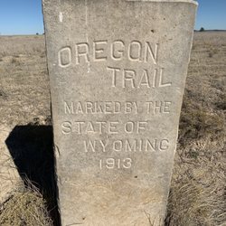
Oregon Trail Ruts Photos


More like Oregon Trail Ruts
Recommended Reviews - Oregon Trail Ruts
Start your review...

Reviews With Photos

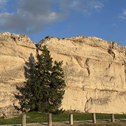
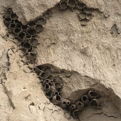
I spent a lot of years hunched over a computer playing Oregon Trail so anytime I can see something related to the actual thing I make a stop. This is truly a wonderful little treasure, easy to find, free, great bit of history! Located very near to the Oregon Trail Wagon Ruts is Register Cliff, which is one of the most prominent of the many places along the Oregon Trail where emigrants would carve their names into the soft rock; more than 700 names can still be seen on this cliff and on other rock outcroppings nearby. But the rock has a history to tell beyond the words inscribed in it. It is, of course, a memorial to the emigrants who felt a need to leave their mark on this significant journey of their lives in which they left behind the world they were born into and traveled for months to a new ones. But it is also a record to others. At one time the names included dates as early as 1829 and one reportedly from 1797. Both of which were judged authentic. If those dates were accurate, they represented the first white people to pass by here, mountain men involved in the fur trade. Many dates, too, were placed on the rocks after the decline of the Oregon Trail. Soldiers from Fort Laramie occasionally inscribed their names. Ranchers and cowboys also scratched their names into the rocks in the years of Wyoming Territory and early statehood. Others since then have occasionally tried to join their historic predecessors by adding their names to the list. But there is more. To Native Americans the marks on this cliff represent a different legacy. One of loss rather than achievement. They also used this rock for inscribing their own marks and at one time some of the Indian pictographs and petroglyphs on the rocks were still visible, but like the land surrounding us that was once the hunting grounds of several Indian nations, those images have been lost in the flood of the white names on the rocks. While leaving the historic area, we also saw several monuments that represent where the Pony Express went through. Make sure to check all this out! Very cool.

A visit to this location was tops on my list when I planned my vacation here. I have read before how the countless wagon wheels war ruts in the rock, but to experience them myself was very moving. My 4X great grandmother would have been one of the pioneers who came through here. My thanks and appreciation to all those who helped create the walkway and signs. If you've been debating about whether or not to add this stop to your itinerary, add it now! There are picnic and bathroom facilities here so it could be a quick stop to let your kids run around and do some exploring, or a place to spend an hour soaking up the history. read more


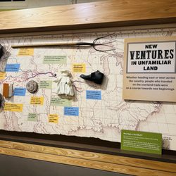
I saw the signage of the Oregon trail ruts sign pointing east and I decided to check things out. It was pretty cool that there's a yelp listing for this attraction as well. While it may not be an excuse to come out all the way here to southeast Wyoming and see where may or may not be wagon ruts made by 1860 American pioneers trying to make better lives for themselves, it was a nice stopover on my way back to Longmont, CO. I had stopped off at touring the Fort Laramie national historic site and, as aforementioned before, I saw the signage of the Oregon trail Ruts historic site and was curious as to what this place was about. I was in the area and figured why not. I arrived around 4:40pm on a brisk and casual Tuesday afternoon in October 2017. Curiosity lead me to this place, which could be considered either a historical landmark or a public park. In truth, it's a little of both. I don't doubt that there are wagon ruts still existing after 100+ years after the iconic westward movement of people forging ahead to reach the Pacific Northwest and other places in Nevada and California. This historic site provides a glimpse into what it was like back in the 1840's for those who wanted a better life in the United States of America. The overall experience here at the Oregon Trail Ruts historical site was interesting, educational, yet inspiring at the same time. They showcase what is the wagon ruts from all those wagons that made historic journeys from Missouri to various places in Oregon, Nevada, and California. For me, because really nobody was there when I was there, I just seemed like it was just a walk in the park - literally. Too bad there is no replica of a wagon train at this site, although it probably would have been vandalized at some point by some kids. That tends to happen. For me, I just happened to just slowly walk around the pathway that circumnavigate the park and looked around and what was there, which was barely nothing. Just some signage but that's about it. This Oregon trail Ruts historic site is located in a remote area of Wyoming, more specifically, in Xxx. The only good part of this experience was the fact that there is no admission charged for entry. The parking was limited, but there is space for you to park in. For the most part though, the Oregon trail ruts is a piece of history that is preserved in the form of a city / county park and as a historic site here. The American pioneers risked their lives to bring forth a better life for themselves and to bring prosperity to a growing nation. I spent about a good 1 1/2 hours before heading to Register Cliff, which happened to be nearby (2 miles). There is a restroom next to the parking area, but I don't think they have public wifi here. I can't say that you may enjoy coming here to the Oregon trail ruts historic site, but if you are fan of the Oregon trail and a general history buff, you may be interested in this. Plus, it's on the way back to Denver and Cheyenne, Wy from Laramie, Wy. You are kind of in the middle of nowhere though, so best bet is to come here with a decent amount of gas in your car and explore the sites in the area, while coming here to see the Oregon trail ruts that these American pioneers have made to create a nation over 150 years ago. I would recommend coming here if you have the time and want to see it. It is kind of on the way, if you are coming from Denver and Fort Laramie, Wyoming. Time well spent. 4.5 stars for the entire experience. Thanks to these brave souls, we would have an America we can be proud of today. Support local! B read more


3 years ago
13 years ago
I spent a lot of years hunched over a computer playing Oregon Trail so anytime I can see something related to the actual thing I make a stop. This is truly a wonderful little treasure, easy to find, free, great bit of history! Located very near to the Oregon Trail Wagon Ruts is Register Cliff, which is one of the most prominent of the many places along the Oregon Trail where emigrants would carve their names into the soft rock; more than 700 names can still be seen on this cliff and on other rock outcroppings nearby. But the rock has a history to tell beyond the words inscribed in it. It is, of course, a memorial to the emigrants who felt a need to leave their mark on this significant journey of their lives in which they left behind the world they were born into and traveled for months to a new ones. But it is also a record to others. At one time the names included dates as early as 1829 and one reportedly from 1797. Both of which were judged authentic. If those dates were accurate, they represented the first white people to pass by here, mountain men involved in the fur trade. Many dates, too, were placed on the rocks after the decline of the Oregon Trail. Soldiers from Fort Laramie occasionally inscribed their names. Ranchers and cowboys also scratched their names into the rocks in the years of Wyoming Territory and early statehood. Others since then have occasionally tried to join their historic predecessors by adding their names to the list. But there is more. To Native Americans the marks on this cliff represent a different legacy. One of loss rather than achievement. They also used this rock for inscribing their own marks and at one time some of the Indian pictographs and petroglyphs on the rocks were still visible, but like the land surrounding us that was once the hunting grounds of several Indian nations, those images have been lost in the flood of the white names on the rocks. While leaving the historic area, we also saw several monuments that represent where the Pony Express went through. Make sure to check all this out! Very cool. read more


5 years ago
12 years ago
A must stop if you're a history buff. It's just amazing to see the exact path where so many people had the biggest and probably scariest adventure of their lives. Also it's free so you might as well check it out! read more


9 years ago
11 years ago
More info about Oregon Trail Ruts
Ask the Community - Oregon Trail Ruts


Why does Yelp recommend reviews?
1 review that is not currently recommended
The reviews below are not factored into the business's overall star rating.
9 years ago
Oregon Trail Ruts - landmarks - Updated July 2026
Best of Guernsey
People found Oregon Trail Ruts by searching for…
Things to Do in Guernsey, Wyoming
Hiking Trails in Guernsey, Wyoming
Public Services & Government in Guernsey, Wyoming
Historical Sites in Guernsey, Wyoming
Sightseeing in Guernsey, Wyoming
Places to Take Pictures in Guernsey, Wyoming
Picnic Areas in Guernsey, Wyoming
Religious Organizations in Guernsey, Wyoming
Tourist Attractions in Guernsey, Wyoming
Arts & Entertainment in Guernsey, Wyoming
Off Road Trails in Guernsey, Wyoming
Points of Interest in Guernsey, Wyoming
Things to See in Guernsey, Wyoming
What to Do in Guernsey, Wyoming
Photo Spots in Guernsey, Wyoming
Attractions in Guernsey, Wyoming
Browse Nearby
BEST of Guernsey, Wyoming Things to Do near Oregon Trail Ruts
BEST of Guernsey, Wyoming Coffee near Oregon Trail Ruts
BEST of Guernsey, Wyoming Restaurants near Oregon Trail Ruts
BEST of Guernsey, Wyoming Shopping near Oregon Trail Ruts
BEST of Guernsey, Wyoming Parks near Oregon Trail Ruts
Browse Brands
Related Searches in Guernsey, WY
Discover Top Nature Parks to Visit in Guernsey, Wyoming
Enjoy the Best Walking Trails in Guernsey, Wyoming
Explore Beautiful Castles and Landmarks in Guernsey, Wyoming
Explore Beautiful Parks and Green Spaces in Guernsey, Wyoming
Explore Nature Spots Around Guernsey, Wyoming
Explore Scenic National Park Locations in Guernsey, Wyoming
Explore the Best Trail Options in Guernsey, Wyoming
Explore the Rich History in Guernsey, Wyoming
Find the Best Bridge Spots in Guernsey, Wyoming
Popular Things to Do in Guernsey, Wyoming
Relax at Natural Hot Springs Near Guernsey, Wyoming