Moore Haven Bridge Photos

More like Moore Haven Bridge
Recommended Reviews - Moore Haven Bridge
Start your review...

Originally, this was a drawbridge built around 1950 to carrying one of the remaining two-lane stretches of US 27 over the Caloosahatchee River. The replacement, a four-lane fixed-span bridge, was built between 1997 and 2000 at which point the original bridge was removed. The bridge incorporates post-tension concrete technology, one of the longest of its kind in the country at 320 feet. It uses haunch girders, which act like a seesaw on top of piers, connected by I-beam girders. These girders were stitched together with cables and grout, creating tension that strengthens the structure. The bridge has 55.5 feet of vertical clearance and that means it's really easy to end up going faster that you intend as you come down the other side. And that's where representatives from the Glades County Sheriff's Department or the Florida Highway Patrol might be waiting to give you an award. But there's no toll to cross the bridge. [Review 417 of 2025 - 2062 in Florida - 23979 overall] read more


More info about Moore Haven Bridge


Moore Haven Bridge - landmarks - Updated May 2026
Best of Moore Haven
People found Moore Haven Bridge by searching for…
Trending Searches in Moore Haven, FL
Boat Rental near Moore Haven Bridge
Botanical Gardens near Moore Haven Bridge
Bounce House Rentals near Moore Haven Bridge
Campgrounds near Moore Haven Bridge
Flower Fields near Moore Haven Bridge
Landmarks & Historical Buildings near Moore Haven Bridge
Nurseries & Gardening near Moore Haven Bridge
Party Equipment Rentals near Moore Haven Bridge
Pedicure near Moore Haven Bridge
Photo Spots near Moore Haven Bridge
Public Services & Government near Moore Haven Bridge
Rv Rental near Moore Haven Bridge
Browse Articles
Browse Nearby
BEST of Moore Haven, Florida Things to Do near Moore Haven Bridge
BEST of Moore Haven, Florida Coffee near Moore Haven Bridge
BEST of Moore Haven, Florida Restaurants near Moore Haven Bridge
BEST of Moore Haven, Florida Parks near Moore Haven Bridge
BEST of Moore Haven, Florida Museums near Moore Haven Bridge
BEST of Moore Haven, Florida Hotels near Moore Haven Bridge
BEST of Moore Haven, Florida Campgrounds near Moore Haven Bridge
BEST of Moore Haven, Florida Breakfast near Moore Haven Bridge
BEST of Moore Haven, Florida Transportation near Moore Haven Bridge
Browse Brands
Related Searches in Moore Haven, FL
Best Fishing Locations and Guides in Moore Haven, Florida
Best Spots for Star Gazing in Moore Haven, Florida
Check Out Off Road Trails in Moore Haven, Florida
Discover Family-Friendly Aquariums in Moore Haven, Florida
Discover Romantic Activities to Enjoy in Moore Haven, Florida
Discover the Best Beaches in Moore Haven, Florida
Enjoy Hiking Adventures in Moore Haven, Florida
Explore Beautiful Parks and Green Spaces in Moore Haven, Florida
Explore Free Things to Do Around Moore Haven, Florida
Explore Scenic Lakes to Visit in Moore Haven, Florida
Explore Secret Spots Worth Visiting in Moore Haven, Florida
Explore Top Things to Do at Night in Moore Haven, Florida
Explore Venues & Event Spaces in Moore Haven, Florida
Find Exciting Tours to Take in Moore Haven, Florida
Find Fun Couples Activities Around Moore Haven, Florida
Find the Best Playgrounds to Visit in Moore Haven, Florida
Popular Kids Activities in Moore Haven, Florida
Popular Things to Do in Moore Haven, Florida
Public Services & Government Offices in Moore Haven, Florida
Secure Convenient Parking Options in Moore Haven, Florida
People who viewed Moore Haven Bridge also viewed
Caloosahatchee River Bridge
3 reviews
Lone Cypress Historical Marker
1 review
Fort Denaud Bridge
2 reviews
The Hurricane of 1928
1 review
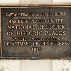
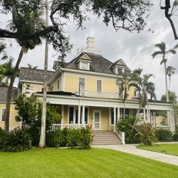
Captain Francis A. Hendry House
1 review
Fort Denaud
1 review
Fort Denaud Cemetery
2 reviews
The Clewiston Chamber of Commerce
1 review
Fort Thompson
1 review
Glades County Courthouse
2 reviews