Metson Lake Photos


You might also consider
More like Metson Lake
Recommended Reviews - Metson Lake
Start your review...

Reviews With Photos

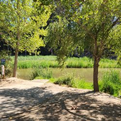
Golden Gate Park is full of some sexy sh*t. I mean, by park standards. It's pretty easy to get lost in the shuffle in a place that has Tea Gardens, Windmills, Bison, Pot-Selling Hippies, Trees, Flowers, Golf Courses (Frisbee and Real), Statues, Trails, Museums... ETC!!! There's a ton of noise and this little lake is like the Oboe in a symphony - it's always there but you only hear it when the rest of the noise stops. (If you know that reference, I just made the liftoff sign in your direction, friend.) Metson Lake is not exactly a hidden gem. It's kinda exactly what you think you would find in Golden Gate Park. By the way, did I mention that Golden Gate Park is the greatest park ever? There are many beautiful little lakes scattered through out the park and this one is not particularly well used. Metson Lake is located directly South of the Polo Fields, up the hill. It has a trail that runs around it and there are many nice places to sit and take in a peaceful moment. It's not exactly off the beaten path, but it's not in a high traffic area so you can avoid the crowds. I'll add two more things. It's a great place to take in some animal life. You can see a variety of birds and an abundance of turtles. ...I wonder how many pet turtles have ended up in Metson Lake. I also witnessed a great moment here when a painter was set up on the shore painting the landscape. There is something about seeing a painter at work En Plein Air. I think it's in one of the photos I added.

One of the cherry blossom trees at Lake Metson is in full bloom. The other one hasn't started to flower yet. Lake Metson is a long hike from the closest parking lot by the cycling track. It is best to bike here. read more


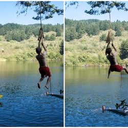
Nice small lake at Golden Gate Park near the Polo Fields. It's definitely not as large-scale as Stowe Lake. I came here to meet somebody for longboard skateboarding down the inclined street by the lake. It was a good stretch and a safe place to do this activity. Steady stream of people coming and going on bikes or walking. It's a nice spot in the park. read more

Golden Gate Park is full of some sexy sh*t. I mean, by park standards. It's pretty easy to get lost in the shuffle in a place that has Tea Gardens, Windmills, Bison, Pot-Selling Hippies, Trees, Flowers, Golf Courses (Frisbee and Real), Statues, Trails, Museums... ETC!!! There's a ton of noise and this little lake is like the Oboe in a symphony - it's always there but you only hear it when the rest of the noise stops. (If you know that reference, I just made the liftoff sign in your direction, friend.) Metson Lake is not exactly a hidden gem. It's kinda exactly what you think you would find in Golden Gate Park. By the way, did I mention that Golden Gate Park is the greatest park ever? There are many beautiful little lakes scattered through out the park and this one is not particularly well used. Metson Lake is located directly South of the Polo Fields, up the hill. It has a trail that runs around it and there are many nice places to sit and take in a peaceful moment. It's not exactly off the beaten path, but it's not in a high traffic area so you can avoid the crowds. I'll add two more things. It's a great place to take in some animal life. You can see a variety of birds and an abundance of turtles. ...I wonder how many pet turtles have ended up in Metson Lake. I also witnessed a great moment here when a painter was set up on the shore painting the landscape. There is something about seeing a painter at work En Plein Air. I think it's in one of the photos I added. read more


17 years ago
Beautiful little lake with ducks, geese, some turtles and greenery all about. Great place to read, eat a sandwich or just relax with your thoughts. Metson Lake is pretty close to the eastern side of the Polo Fields in GGPark, and is right along side of Middle Drive West. One of the best things Metson Lake has going for it is that Middle Dr. W. is not a through street and thus does not receive much traffic -making the lake a bit more secluded than its fellow bodies of water. Next time you're in this area of the park, or even near 30th and Lincoln, come check out the tranquility of Metson Lake. read more


14 years ago
More info about Metson Lake
Ask the Community - Metson Lake
You might also consider


Metson Lake - lakes - Updated May 2026
Best of San Francisco
People found Metson Lake by searching for…
Swimming Holes in San Francisco, California
Parks in San Francisco, California
Duck Pond in San Francisco, California
Secret Spots in San Francisco, California
Swimming Lakes in San Francisco, California
Walking Trails in San Francisco, California
Picnic Areas in San Francisco, California
Lakes & Ponds in San Francisco, California
Parks With Lakes in San Francisco, California
Trail in San Francisco, California
Hiking Trails in San Francisco, California
Secluded Spots in San Francisco, California
Running Trails in San Francisco, California
Places to Run in San Francisco, California
Fun Things to Do in San Francisco, California
Water in San Francisco, California
Things to Do With Kids in San Francisco, California
Parks for Kids in San Francisco, California
Playground in San Francisco, California
Fishing Ponds in San Francisco, California
Photo Spots in San Francisco, California
Duck in San Francisco, California
Trending Searches in San Francisco, CA
Botanical Gardens near Metson Lake
Bounce House Rentals near Metson Lake
Camping Sites near Metson Lake
Cherry Picking near Metson Lake
Dog Friendly Trails near Metson Lake
Nurseries & Gardening near Metson Lake
Outdoor Basketball Courts near Metson Lake
Outdoor Furniture Stores near Metson Lake
Parks With Pull Up Bars near Metson Lake
Party Equipment Rentals near Metson Lake
Pick Your Own Farms near Metson Lake
Places To Take Pictures near Metson Lake
Scenic Restaurants near Metson Lake
Strawberry Picking near Metson Lake
Swimming Holes near Metson Lake
Table And Chair Rentals near Metson Lake
Volleyball Courts near Metson Lake
Browse Articles
Browse Nearby
BEST of San Francisco, California Things to Do near Metson Lake
BEST of San Francisco, California Coffee near Metson Lake
BEST of San Francisco, California Fishing Spots near Metson Lake
BEST of San Francisco, California Parks near Metson Lake
BEST of San Francisco, California Restaurants near Metson Lake
BEST of San Francisco, California Campgrounds near Metson Lake
BEST of San Francisco, California Breakfast near Metson Lake
BEST of San Francisco, California Sightseeing near Metson Lake
Browse Brands
Related Searches in San Francisco, CA
Affordable Kayak Rental Services in San Francisco, California
Best Fishing Locations and Guides in San Francisco, California
Best Waterfalls and Swimming Holes in San Francisco, California
Discover Lakes & Ponds to Explore in San Francisco, California
Discover Top State Parks to Visit in San Francisco, California
Discover Walking Parks in San Francisco, California Near You
Discover the Best Beaches in San Francisco, California
Discover the Best Fishing Lake in San Francisco, California
Discover the Best Tide Pools in San Francisco, California
Enjoy Kayaking Adventures in San Francisco, California
Enjoy Water Activities and Fun in San Francisco, California
Enjoy the Best Walking Trails in San Francisco, California
Explore Beautiful Parks and Green Spaces in San Francisco, California
Explore Boat Rentals for Every Need in San Francisco, California
Explore Easy Hikes Perfect for All in San Francisco, California
Explore Parks With Lakes to Visit in San Francisco, California
Explore Popular Campgrounds Near San Francisco, California
Explore Popular Picnic Areas Around San Francisco, California
Explore Popular RV Parks Around San Francisco, California
Explore Popular Scenic Views Near San Francisco, California
Explore Top Dog Parks in San Francisco, California Near You
Explore Top Marinas Near San Francisco, California
Explore Top Water Parks in San Francisco, California Today
Explore the Best Swimming Holes Around San Francisco, California
Explore the Best Trail Options in San Francisco, California
Explore the Scenic River in San Francisco, California
Find Beautiful Views in San Francisco, California
Find Cozy Camping Cabins in San Francisco, California
Find Parks and Recreation Activities in San Francisco, California
Find Top Dog Friendly Parks to Visit in San Francisco, California
Find Top Dog Swimming Spots in San Francisco, California
Find Top-Rated Waterfalls in San Francisco, California Now
Find the Best Parks for Picnics in San Francisco, California
Find the Best Playgrounds to Visit in San Francisco, California
Find the Best Swimming Pools in San Francisco, California Today
Great Places to Swim in San Francisco, California
Have Fun at a Splash Pad in San Francisco, California
Hiking Trails With Waterfalls in San Francisco, California
Play at a Splash Pad Park in San Francisco, California
Popular Fishing Spots to Explore in San Francisco, California
Relax at Natural Hot Springs Near San Francisco, California
Safe River Swimming Areas in San Francisco, California
Safe and Fun Parks for Kids in San Francisco, California
Top Hiking Trails to Explore in San Francisco, California
Top Playgrounds for Kids to Enjoy in San Francisco, California
Top Running Trails to Explore in San Francisco, California
Top Swimming Lakes to Enjoy in San Francisco, California
Top Swimming Spots and Pools in San Francisco, California
People who viewed Metson Lake also viewed
Lake Merced
286 reviews
Lakeshore
Spreckels Lake
38 reviews
Crane Cove Park
19 reviews
Dogpatch, Potrero Hill
Laguna Honda Reservoir
8 reviews
Inner Sunset, Twin Peaks
Brooks Park
16 reviews
Ingleside Heights
Lloyd Lake
11 reviews
Mallard Lake
3 reviews
Bayfront Park
8 reviews
Mission Bay
Edgehill Mountain Park
3 reviews
Forest Hill
Blue Heron Lake
136 reviews