Margarette Falls Trail Photos


You might also consider
More like Margarette Falls Trail
Recommended Reviews - Margarette Falls Trail
Start your review...

Reviews With Photos


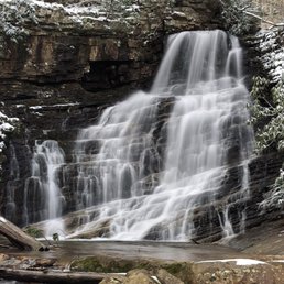
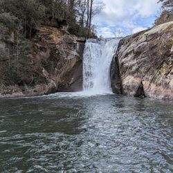
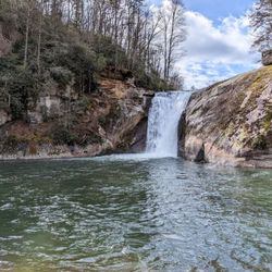
The Margarette Falls Trail at Cherokee National Forest is a moderate 2.7 mile out-and-back hike. I hiked this in July so the weather was warm with possible rain (no rain came, yay!) and the forest was lush green with the sound of the creek and falls the entire way. This is a moderate hike with plenty of rocky patches that last about 0.2 miles (ish) in length and can be difficult to hike on, so watch your footing. You'll also need to cross a creek. My advise is to wear appropriate footwear and walk through the water vs stepping on the slippery rocks. The start of the trail is a easy gravel path with a slight incline. About .5 up the path you will reach the trail map at the intersection. Follow the signs for Margarette Faills Trail (blue blaze). You'll cross over a metal bridge, climb up a path of rocks, walk through a creek and work your way up to see Ms. Margarette. The falls are gorgeous! Bring your camera... and maybe something to protect it from the weather and water. The trailhead is well maintained with plenty of spots to park. I was able to find it easy with GPS. You'll drive down lovely country and residential roads. While the hike is rated moderate, the destination is well worth the effort.

Very well marked and maintained trail. According to my Apple Watch, it's 1.49 miles from the trailhead to Margarette Falls. There is a very moderate gain in elevation as you make your way towards said cascade, but it's an easy hike for anyone in decent shape. To capture compelling images with your iPhone, I recommend using a GorillaPod along with either Slow Shutter or Moment. Both of the aforementioned apps facilitate long exposure simulation captures.

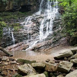
It's a bit out of the way and not easy to find, but this hike is challenging and the payoff makes it worth the trek. The drive through winding backroads made me question my decision to find this but I am glad I did! Don't blink because you will miss the sign pointing to two trails, one of which is Margarette Falls. The gravel parking lot is not marked with a sign, and you have to hike up an access road for a half mile until you get to a kiosk. The trail becomes more narrow and rockier as you ascend the trail and a couple of times I was fortunate the blue placards on the trees denoted the trail. The trail itself follows the river and lots of small waterfalls make for great photos. There is a bridge to cross the river and then you have to cross the river again, this time via rock hopping. Make sure you are ok with getting wet! When you question whether or not you are doing the right thing, you hit the payoff! Worth it all the way. I am an experienced hiker and I'd rate it moderate.

A great little hike. Kinda steep, but not treacherous. There are a couple of stream crossings. We took our 2 small dogs and it was fine. One older couple stopped about halfway up and decided to turn back. It's a good thing because the steeper parts were still ahead. The flow at the falls apparently varies and this spring it was gorgeous! Unlike the previous reviewer, I am not a very experienced hiker in recent years and now that I'm getting fatter and older, it was fairly strenuous. The falls are a photographer's dream.
WORTH THE EFFORT!!! I am not used to hiking so I found parts of this trail to be very strenuous. There's a section where you walk on nothing but rocks so I suggest bringing a walking stick/hiking pole because it will come in handy. We met a very nice elderly lady on the way up who told us she was 90% blind and has been on this trail several times. So I feel if she can do it so can anyone else! There are plenty of pretty mini water falls and stops to take pictures on the way up! Wear some good shoes and bring water shoes and a change of clothes if you plan to get in the swimming hole at the very top. The main waterfall at the top is so worth it! The water is natural spring water straight off the mountain so it is COLD even in 85 degree weather but feels SO good on your tired feet and legs once you make it there! Would definitely recommend this little hidden gem to anyone!

Other people are reporting it is 1.7 miles round-trip. The total mileage for this hike is actually 2.9 in and out. The first .75 miles is a wide flat gravel road bed. Then you reach the beginning of the Margarette Falls Trail at the kiosk. From this point it is .7 miles to the falls. Here it becomes a natural surface trail that, in some places, large rocks have been laid because of erosion. Watch out for snakes. There is one small scramble that seem like it will take lots of effort when you first see it but it's really much easier than you will think. There is one wide creek crossing. Be prepared for the possibility of wet feet here after rain. Lots of photo ops. Beautiful when green and in the fall.

28 days ago


11 months ago
We enjoyed our hike - from car, to falls and back was a little over 3 miles. It is a great hike but bring a walking stick to help navigate some of the rocky areas- you do cross a creek but the rocks were easy to cross without getting wet and were not slippery. On the way down you really tend to enjoy the views - because you aren't focused on getting to the end ;) my husband and I - are out of shape lol but it was not that bad of a hike - our daughter , who is an athlete had no issues - but there is a good 30 ye diff between us ha! I highly recommend spending a few hours enjoying nature ;) read more


3 years ago
2 years ago
The hike was good. It took me about 1 hour to hike all the way up. You walk along a creek the whole time. By the pictures it looks like there are multiple waterfalls but there's 1 I'd say And it's the one all the way at the end of the trail read more


The Margarette Falls Trail at Cherokee National Forest is a moderate 2.7 mile out-and-back hike. I hiked this in July so the weather was warm with possible rain (no rain came, yay!) and the forest was lush green with the sound of the creek and falls the entire way. This is a moderate hike with plenty of rocky patches that last about 0.2 miles (ish) in length and can be difficult to hike on, so watch your footing. You'll also need to cross a creek. My advise is to wear appropriate footwear and walk through the water vs stepping on the slippery rocks. The start of the trail is a easy gravel path with a slight incline. About .5 up the path you will reach the trail map at the intersection. Follow the signs for Margarette Faills Trail (blue blaze). You'll cross over a metal bridge, climb up a path of rocks, walk through a creek and work your way up to see Ms. Margarette. The falls are gorgeous! Bring your camera... and maybe something to protect it from the weather and water. The trailhead is well maintained with plenty of spots to park. I was able to find it easy with GPS. You'll drive down lovely country and residential roads. While the hike is rated moderate, the destination is well worth the effort. read more

4 years ago
It was a beautiful trail. My fiancé and I about made it to the top when we heard something that sounded like a bear so we turned around since we are not experienced around here but other than that there was lots of beautiful trees mushrooms and streams running through it read more
Very well marked and maintained trail. According to my Apple Watch, it's 1.49 miles from the trailhead to Margarette Falls. There is a very moderate gain in elevation as you make your way towards said cascade, but it's an easy hike for anyone in decent shape. To capture compelling images with your iPhone, I recommend using a GorillaPod along with either Slow Shutter or Moment. Both of the aforementioned apps facilitate long exposure simulation captures. read more


2 years ago
9 years ago
It's a bit out of the way and not easy to find, but this hike is challenging and the payoff makes it worth the trek. The drive through winding backroads made me question my decision to find this but I am glad I did! Don't blink because you will miss the sign pointing to two trails, one of which is Margarette Falls. The gravel parking lot is not marked with a sign, and you have to hike up an access road for a half mile until you get to a kiosk. The trail becomes more narrow and rockier as you ascend the trail and a couple of times I was fortunate the blue placards on the trees denoted the trail. The trail itself follows the river and lots of small waterfalls make for great photos. There is a bridge to cross the river and then you have to cross the river again, this time via rock hopping. Make sure you are ok with getting wet! When you question whether or not you are doing the right thing, you hit the payoff! Worth it all the way. I am an experienced hiker and I'd rate it moderate. read more


 - Hiking Near Me - Greeneville, Tennessee")

A great little hike. Kinda steep, but not treacherous. There are a couple of stream crossings. We took our 2 small dogs and it was fine. One older couple stopped about halfway up and decided to turn back. It's a good thing because the steeper parts were still ahead. The flow at the falls apparently varies and this spring it was gorgeous! Unlike the previous reviewer, I am not a very experienced hiker in recent years and now that I'm getting fatter and older, it was fairly strenuous. The falls are a photographer's dream. read more


6 years ago
4 years ago
6 years ago
WORTH THE EFFORT!!! I am not used to hiking so I found parts of this trail to be very strenuous. There's a section where you walk on nothing but rocks so I suggest bringing a walking stick/hiking pole because it will come in handy. We met a very nice elderly lady on the way up who told us she was 90% blind and has been on this trail several times. So I feel if she can do it so can anyone else! There are plenty of pretty mini water falls and stops to take pictures on the way up! Wear some good shoes and bring water shoes and a change of clothes if you plan to get in the swimming hole at the very top. The main waterfall at the top is so worth it! The water is natural spring water straight off the mountain so it is COLD even in 85 degree weather but feels SO good on your tired feet and legs once you make it there! Would definitely recommend this little hidden gem to anyone! read more


8 years ago
Other people are reporting it is 1.7 miles round-trip. The total mileage for this hike is actually 2.9 in and out. The first .75 miles is a wide flat gravel road bed. Then you reach the beginning of the Margarette Falls Trail at the kiosk. From this point it is .7 miles to the falls. Here it becomes a natural surface trail that, in some places, large rocks have been laid because of erosion. Watch out for snakes. There is one small scramble that seem like it will take lots of effort when you first see it but it's really much easier than you will think. There is one wide creek crossing. Be prepared for the possibility of wet feet here after rain. Lots of photo ops. Beautiful when green and in the fall. read more


7 years ago
Although when I went, it rained from beginning to end, this short hike was amazing! The trail was easy enough that anyone from any age can easily handle it! It was a little over a mile in to get to the waterfall itself, but worth every step! It is a very dog friendly hike as well! Along the way, the sights are beautiful! So much color surrounding you no matter which direction you look! We didn't see much for wildlife other than some lizards(and the occasional mosquito), but I'm guessing that's because of the rain. All in all, I would recommend this hike to anyone who enjoys nature! read more


More info about Margarette Falls Trail
1285 Shelton Mission Rd
Greeneville, TN 37743
Directions
Hours
Outdoor Amenities
Ask the Community - Margarette Falls Trail
Review Highlights - Margarette Falls Trail


Margarette Falls Trail - hiking - Updated June 2026
Best of Greeneville
People found Margarette Falls Trail by searching for…
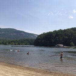
Swimming Holes in Greeneville, Tennessee
Things to Do in Greeneville, Tennessee
Hiking Trails With Waterfalls in Greeneville, Tennessee
Parks in Greeneville, Tennessee
Photo Spots in Greeneville, Tennessee
Places to Take Pictures in Greeneville, Tennessee
River Swimming in Greeneville, Tennessee
Secret Spots in Greeneville, Tennessee
Scenic Drive in Greeneville, Tennessee
Waterfalls in Greeneville, Tennessee
Scenic Overlook in Greeneville, Tennessee
Off Road Trails in Greeneville, Tennessee
Easy Hikes in Greeneville, Tennessee
Dog Friendly Hiking Trails in Greeneville, Tennessee
Attractions in Greeneville, Tennessee
Running Trails in Greeneville, Tennessee
Walking Trails in Greeneville, Tennessee
Swimming Lakes in Greeneville, Tennessee
Beautiful Views in Greeneville, Tennessee
View Points in Greeneville, Tennessee
Swimming in Greeneville, Tennessee
Secluded Spots in Greeneville, Tennessee
Trending Searches in Greeneville, TN
Boat Rental near Margarette Falls Trail
Caves near Margarette Falls Trail
Cliff Jumping near Margarette Falls Trail
Creeks near Margarette Falls Trail
Day Trips near Margarette Falls Trail
Fishing Spots near Margarette Falls Trail
Kayak Rental near Margarette Falls Trail
Lakes & Ponds near Margarette Falls Trail
Landmarks & Historical Buildings near Margarette Falls Trail
Lookout Points near Margarette Falls Trail
Off Road Trails near Margarette Falls Trail
Places To Swim near Margarette Falls Trail
Pool Supplies near Margarette Falls Trail
Public Art near Margarette Falls Trail
Public Pools near Margarette Falls Trail
Public Shower near Margarette Falls Trail
River Swimming near Margarette Falls Trail
River Tubing near Margarette Falls Trail
Rock Quarry near Margarette Falls Trail
Scenic Overlook near Margarette Falls Trail
Scenic Restaurants near Margarette Falls Trail
Secluded Spots near Margarette Falls Trail
Splash Pad near Margarette Falls Trail
Strawberry Picking near Margarette Falls Trail
Swimming Holes near Margarette Falls Trail
Swimming Lakes near Margarette Falls Trail
Browse Brands
Related Searches in Greeneville, TN
Affordable Kayak Rental Services in Greeneville, Tennessee
Beautiful Flower Fields in Greeneville, Tennessee
Best Fishing Locations and Guides in Greeneville, Tennessee
Best Fun Things to Do in Greeneville, Tennessee
Best Lookout Points to Visit in Greeneville, Tennessee
Best Places for Horseback Riding in Greeneville, Tennessee
Best Sledding Spots and Fun in Greeneville, Tennessee
Best Things to Do on a Rainy Day in Greeneville, Tennessee
Best Waterfalls and Swimming Holes in Greeneville, Tennessee
Book Engaging Historical Tours in Greeneville, Tennessee
Check Out Off Road Trails in Greeneville, Tennessee
Discover Charming Historic Homes in Greeneville, Tennessee
Discover Family-Friendly Aquariums in Greeneville, Tennessee
Discover Famous Monuments in Greeneville, Tennessee
Discover Historic Sites and Places in Greeneville, Tennessee
Discover Lakes & Ponds to Explore in Greeneville, Tennessee
Discover Popular Photo Spots in Greeneville, Tennessee
Discover Scenic Mountain Bike Trails Near Greeneville, Tennessee
Discover the Best Beaches in Greeneville, Tennessee
Discover the Best Night Hike Trails in Greeneville, Tennessee
Discover the Best Running Track in Greeneville, Tennessee
Enjoy Arts & Entertainment in Greeneville, Tennessee
Enjoy Exciting Mountain Biking Adventures in Greeneville, Tennessee
Enjoy Hiking Adventures in Greeneville, Tennessee
Enjoy Kayaking Adventures in Greeneville, Tennessee
Enjoy Tent Camping Spots Around Greeneville, Tennessee
Enjoy the Best Night View Spots in Greeneville, Tennessee
Enjoy the Best Tubing Experiences in Greeneville, Tennessee
Exciting Cliff Jumping Spots in Greeneville, Tennessee
Experience Stunning Sunset Views in Greeneville, Tennessee
Explore Beautiful Botanical Gardens in Greeneville, Tennessee
Explore Beautiful Castles and Landmarks in Greeneville, Tennessee
Explore Beautiful Parks and Green Spaces in Greeneville, Tennessee
Explore Children's Museums Near Greeneville, Tennessee
Explore Family-Friendly Zoos and Wildlife in Greeneville, Tennessee
Explore Free Things to Do Around Greeneville, Tennessee
Explore Fun Activities to Do in Greeneville, Tennessee
Explore Fun Field Trips in Greeneville, Tennessee
Explore Popular Campgrounds Near Greeneville, Tennessee
Explore Popular RV Parks Around Greeneville, Tennessee
Explore Popular Scenic Overlook Points in Greeneville, Tennessee
Explore Popular View Points Around Greeneville, Tennessee
Explore Scenic Lakes to Visit in Greeneville, Tennessee
Explore Top Art Galleries Located in Greeneville, Tennessee
Explore Top Dog Parks in Greeneville, Tennessee Near You
Explore Top Water Parks in Greeneville, Tennessee Today
Explore Venues & Event Spaces in Greeneville, Tennessee
Explore Vibrant Public Art Displays in Greeneville, Tennessee
Browse Articles
People who viewed Margarette Falls Trail also viewed
Buffalo Mountain Park
6 reviews
Rock Creek Falls
4 reviews
Tweetsie Trail
10 reviews
Lamar Alexander Rocky Fork State Park
6 reviews
Tannery Knobs Mountain Bike Park
3 reviews
USA Raft Nolichucky River
24 reviews
Triple Creek Campground
8 reviews
Nolichucky Gorge Campgrounds
5 reviews
Bucktown Stables
9 reviews
Andrew Johnson National Historic Site
18 reviews