Madrone Trail Photos


You might also consider
More like Madrone Trail
Recommended Reviews - Madrone Trail
Start your review...

Reviews With Photos

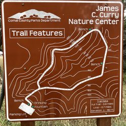
STAY ON TRAIL! All the signs proclaim, yet every hundred or so feet there'll be a branching pathway or intersection that isn't indicated on the overall map... Don't bother with the criss-crossing confusion that's the northeastern portion of the trail. To get to the actual trail, enter by the big Madrone Trail sign, make your first left, then keep straight until you get to a smaller signpost, and go left again. We wandered around for forty-five minutes just attempting to find this route in which to start the 7 mile hike. Don't expect to find much in the way of signage as you continue along either. If you enjoy aimlessly wandering along rough paths that are either extremely rocky or muddy, with no payout in terms of a nice view, then congrats, you've found your place. I thought that a trail on a peninsula jutting out into a lake would be scenic, but nope, Texas fooled me yet again. You'll catch glimpses of the lackluster view occasionally, but this trail mostly stays too far inland or low elevation to see much of anything pretty. Being comfortable but competent footwear... you'll be traversing sharp stone most of the way. No water anywhere. Only one toilet at the start. The trail winds about what look like a camping ghost town... so many abandoned picnic benches, restrooms, trash cans, fire pits, crumbling asphalt roads... all indications this may have once been a place to enjoy camping but now there's nothing but this pointless trail remaining. It's free, and that's the only thing going for it. :/

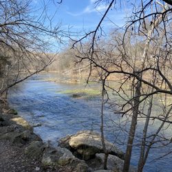
What a gorgeous trail! This was such a good find. Plus nothing else was open because of the holiday. I needed a short hike to shake off the day and this was it! Gravel nature trails that led me down to the lake and back within 30 minutes. I saw a few people along the trail which was nice too! All the trails led back to the parking area and they're easy to read on the map in case you feel lost. Highly recommended! read more


1 year ago
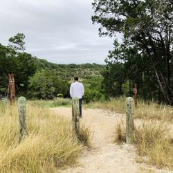
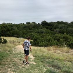
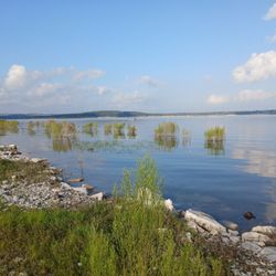
Time for a 2025 update on the changes to the visitor experience here at Madrone Trail. My past reviews go over the terrain (varied with rock gardens, shade, & minimal elevation change) and rules (stay on trail; no lake swimming access). Check those older reports for more details. The biggest change since my last update is the opening of the Butterfly Garden just a few yards from the trailhead off Canyon Park Road. This curated and annotated pocket park is a neat little fenced-in microbiome of native plants offering a great place to observe the changing seasons and pollinators at work. The local chapter of Texas Master Naturalists have done a wonderful job here! The devastating drought in Central Texas for the past several years has dropped the level of Canyon Lake by 29 feet and there's no end in sight. This is sad for many reasons, but offers some interesting opportunities at Madrone Trail in early 2025. The shoreline has changed dramatically and you can now see what used to be under water since 1968. During our most recent visits in 2024-2025, we've walked on uncovered asphalt roads that used to service the Hancock community. We've also found sunken water craft and all sorts of lost objects from boaters over the years. WORD (the local nonprofit that stewards this park) is currently cleaning up all 85 miles of Canyon Lake's shore, so most of the big items will be taken away soon. However, it's always appreciated when trail visitors bring a trash bag and pick up any smaller debris encountered along the way. read more


Fun trail to do with your furry friends! Lots of good signs although still easy to stir off some paths. We did two miles to get used to the path, but I'll definitely be back to add more miles to our hike. Not too busy when we went and only encountered a bike rider once. read more


3 months ago
STAY ON TRAIL! All the signs proclaim, yet every hundred or so feet there'll be a branching pathway or intersection that isn't indicated on the overall map... Don't bother with the criss-crossing confusion that's the northeastern portion of the trail. To get to the actual trail, enter by the big Madrone Trail sign, make your first left, then keep straight until you get to a smaller signpost, and go left again. We wandered around for forty-five minutes just attempting to find this route in which to start the 7 mile hike. Don't expect to find much in the way of signage as you continue along either. If you enjoy aimlessly wandering along rough paths that are either extremely rocky or muddy, with no payout in terms of a nice view, then congrats, you've found your place. I thought that a trail on a peninsula jutting out into a lake would be scenic, but nope, Texas fooled me yet again. You'll catch glimpses of the lackluster view occasionally, but this trail mostly stays too far inland or low elevation to see much of anything pretty. Being comfortable but competent footwear... you'll be traversing sharp stone most of the way. No water anywhere. Only one toilet at the start. The trail winds about what look like a camping ghost town... so many abandoned picnic benches, restrooms, trash cans, fire pits, crumbling asphalt roads... all indications this may have once been a place to enjoy camping but now there's nothing but this pointless trail remaining. It's free, and that's the only thing going for it. :/ read more


2 years ago
pretty nice walk overall. they had a sad 'pollination garden' thing with like 3 flowers in it left alive. lake was more dry so not as scenic. read more

More info about Madrone Trail
Ask the Community - Madrone Trail


Madrone Trail - hiking - Updated May 2026
Best of Canyon Lake
People found Madrone Trail by searching for…
Beautiful Views in Canyon Lake, TX
River Swimming in Canyon Lake, TX
Off Road Trails in Canyon Lake, TX
Hiking Trails in Canyon Lake, TX
Running Trails in Canyon Lake, TX
Swimming Lakes in Canyon Lake, TX
Mountain Biking in Canyon Lake, TX
Campgrounds in Canyon Lake, TX
Scenic View in Canyon Lake, TX
Picnic Spots in Canyon Lake, TX
Free Things to Do in Canyon Lake, TX
Dog Swimming in Canyon Lake, TX
Things to Do on a Rainy Day in Canyon Lake, TX
Tent Camping in Canyon Lake, TX
Walking Trails in Canyon Lake, TX
Things to Do With Teenagers in Canyon Lake, TX
Picnic Areas in Canyon Lake, TX
Sunrise View in Canyon Lake, TX
Off Leash Dog Hikes in Canyon Lake, TX
Tourist Attractions in Canyon Lake, TX
Trending Searches in Canyon Lake, TX
Boat Rental near Madrone Trail
Botanical Gardens near Madrone Trail
Bounce House Rentals near Madrone Trail
Campgrounds near Madrone Trail
Cheap Plants near Madrone Trail
Cliff Jumping near Madrone Trail
Floral Designers near Madrone Trail
Flower Fields near Madrone Trail
Flower Shop near Madrone Trail
Garage Sales near Madrone Trail
Garden Center near Madrone Trail
Lakes & Ponds near Madrone Trail
Nurseries & Gardening near Madrone Trail
Outdoor Activities near Madrone Trail
Outdoor Furniture Stores near Madrone Trail
Party Equipment Rentals near Madrone Trail
Photo Spots near Madrone Trail
Picnic Areas near Madrone Trail
Places To Take Pictures near Madrone Trail
Rock Quarry near Madrone Trail
Running Trails near Madrone Trail
Scenic Drive near Madrone Trail
Sunrise View near Madrone Trail
Swimming Holes near Madrone Trail
Table And Chair Rentals near Madrone Trail
Browse Articles
Browse Nearby
BEST of Canyon Lake, Texas Coffee near Madrone Trail
BEST of Canyon Lake, Texas Restaurants near Madrone Trail
BEST of Canyon Lake, Texas Scenic View near Madrone Trail
BEST of Canyon Lake, Texas Things to Do near Madrone Trail
BEST of Canyon Lake, Texas Parks near Madrone Trail
BEST of Canyon Lake, Texas Breakfast near Madrone Trail
BEST of Canyon Lake, Texas Campgrounds near Madrone Trail
Browse Brands
Related Searches in Canyon Lake, TX
Affordable Kayak Rental Services in Canyon Lake, Texas
Best Fishing Locations and Guides in Canyon Lake, Texas
Best Places for Horseback Riding in Canyon Lake, Texas
Best Waterfalls and Swimming Holes in Canyon Lake, Texas
Check Out Off Road Trails in Canyon Lake, Texas
Discover Dog Friendly Trails to Explore in Canyon Lake, Texas
Discover Kid Friendly Hiking Trails in Canyon Lake, Texas
Discover Scenic Mountain Bike Trails Near Canyon Lake, Texas
Discover a Hiking Trail in Canyon Lake, Texas
Discover the Best Night Hike Trails in Canyon Lake, Texas
Dog-Friendly Hikes With Dogs in Canyon Lake, Texas
Enjoy Camping Adventures Around Canyon Lake, Texas
Enjoy Exciting Mountain Biking Adventures in Canyon Lake, Texas
Enjoy Kayaking Adventures in Canyon Lake, Texas
Enjoy River Tubing Adventures in Canyon Lake, Texas
Enjoy Tent Camping Spots Around Canyon Lake, Texas
Enjoy the Best Tubing Experiences in Canyon Lake, Texas
Enjoy the Best Walking Trails in Canyon Lake, Texas
Exciting Cliff Jumping Spots in Canyon Lake, Texas
Experience Thrilling White Water Rafting in Canyon Lake, Texas
Explore Beautiful Parks and Green Spaces in Canyon Lake, Texas
Explore Easy Hikes Perfect for All in Canyon Lake, Texas
Explore Fun Activities to Do in Canyon Lake, Texas
Explore Nature Spots Around Canyon Lake, Texas
Explore Popular Campgrounds Near Canyon Lake, Texas
Explore Popular Scenic Overlook Points in Canyon Lake, Texas
Explore the Best Beach Spots in Canyon Lake, Texas
Explore the Best Boating Spots in Canyon Lake, Texas
Explore the Best Swimming Holes Around Canyon Lake, Texas
Find Beautiful Views in Canyon Lake, Texas
Find Cozy Camping Cabins in Canyon Lake, Texas
Find Parks and Recreation Activities in Canyon Lake, Texas
Find Popular Ziplining Spots Around Canyon Lake, Texas
Find the Best Parks for Picnics in Canyon Lake, Texas
Find the Best Scenic View Locations in Canyon Lake, Texas
Hiking Trails With Waterfalls in Canyon Lake, Texas
Off Leash Dog Hiking Trails in Canyon Lake, Texas
Plan a Scenic Drive Route Near Canyon Lake, Texas
Popular Fishing Spots to Explore in Canyon Lake, Texas
Popular Outdoor Activities to Try in Canyon Lake, Texas
Popular Picnic Spots to Visit in Canyon Lake, Texas
Safe River Swimming Areas in Canyon Lake, Texas
Safe and Fun Parks for Kids in Canyon Lake, Texas
Top Climbing Spots and Gyms in Canyon Lake, Texas
Top Paddleboarding Activities in Canyon Lake, Texas
Top Places for Snorkeling in Canyon Lake, Texas
Top Running Trails to Explore in Canyon Lake, Texas
Top Swimming Lakes to Enjoy in Canyon Lake, Texas