M Trail Photos


More like M Trail
Recommended Reviews - M Trail
Start your review...

Reviews With Photos


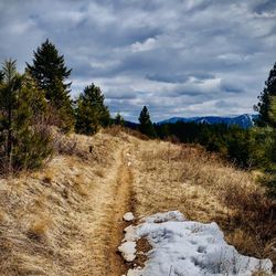
If you use Google Maps to go to Mount Sentinel, it'll route you on the other side and directly up to the mountain. Instead you should find directions to Phyllis Washington Park on the University of Montana campus instead and that should take you close to the parking lot and trailhead. This hike and the M is managed by UM and you'll need to pay during the week but it is free on the weekends and there's tons of parking in the lot. There's a couple ways to go up the main way, but the one that you see on AllTrails is the shortest but also has the higher elevation gain within a short distance. From the trailhead to the top of the mountain it's a ~2,000ft elevation gain in ~1.5miles which makes this a steep hike. There are switchbacks at the beginning that have constant incline but there are benches along the way if you need to take a rest. It's very rocky as well and there are a couple other directions that you can go that are a bit longer but not as rocky. It's also good to go down those ways too since it's better on your knees. I consider myself in decent shape but there were many times when I considered not going all the way up because I was exhausted and dripping sweat, but I took breaks as I needed as persevered to the top and I'm glad. The view from the top is amazing and way better than what you would see only to the M or halfway. When I visited Missoula for the first time I was seeing that M from all over the city and it looked tiny from a distance but when I came up on it it was so huge that I didn't even realize it was right next to me! It's definitely a moderate hike even though it's relatively short because of the fast elevation gain.
")
The cheapest and awesomest thing you can do by yourself or even with your colleagues is to hike. Since this spot is at striking distance from out hotel, we gathered up all our coworkers and set off for that giant M on the side of that mountain. Right before you start the climb, there is a bathroom. Stop here if you have a weak bladder. The switchbacks are pretty easy. We did bring along someone who never hiked before and the benches at the end does help. Took us a bit to get to the M, but eventually we made it. I carried her to go breakfast. We sat down at the top and ate it while enjoying the wonderful view. Anyways, life is awesome when there are places like these. The trail is definitely pretty well kept. We even saw a doe on the way up. She was hella excited to see it. Thank you so much for reading my review. I hope this helps with your decision making experience. Enjoy your awesome yelptastic day!!!

The M hike is a great trail. About 30 mins one way. Straight up with traverses. All ages. I saw a few families and elderly on the trail. As a 27 year old in good shape I thought it would be a piece of cake. Well I started going up and it isn't easy haha but if a kid can do it and an 85 year old, you can! Trail does get busy as morning picks up. Great view of Missoula.

I hiked this trail with my wife last month early on a Saturday Morning. Whenever we had arrived into Missoula I immediately took note of the M on the hill and once I learned that we could hike up to it I knew that I wanted to. Parking for the trail is on the University of Montana campus and although it took us a little while to find it there were plenty of empty spaces. The hike up to the M consists of a number of different switchbacks all while constantly going up. If I remember correctly it is about 700 ft and .7 miles up to the bottom of the M. The trail continues up to the top of the mountain and I wish that my wife and I had the time to do it but on this day we did not. Even so that is quite a bit of climbing in a short amount of time. Thankfully the trails are well manicured and the view at the M makes it all worthwhile. Whenever you turn around and look back out towards Missoula you have an amazing panoramic view which you won't forget. The bottom line for me is that I would do this hike again and again. Don't get me wrong, this is certainly a strenuous hike, especially if you aren't used to much vertical. However the sense of accomplishment combined with the view from the M easily make it worth its while.

Upon pulling into the parking lot at the University of Montana, and looking up at the "hillside", my first thought was, this hike is going to be a piece of cake! In this case, looks are indeed very deceiving. This hike is very steep! You do have the option of using the switchbacks to go up the mountain, but we went straight up and straight down. My recommendations are to start early in the day during the summer, bring water, and bring walking sticks if you have them, especially for the hike down. If you have any breathing issues (asthma, COPD), bring your inhaler AND consider using the switchbacks. It is a beautiful and worthwhile hike. I'm so glad we did it!

2 days ago
I LOVE the M trails in Montana! I've never seen anything like it in other states but they're so cute and always great little hikes. I live in Bozeman so I was very excited to compare M trails. The parking here was a little stressful as there are only 3 visitor spots and the rest you need a campus tag. It's nice for the students that it's so close by (that's not the case in Bozeman) but hard if you're not a student. There is only one way up to the M while there are several ways up to the Bozeman one. I loved the Strava map that showed all the crazy looking switch backs but in reality it was an easy hike with amazing views. The wildflowers were so vibrant and I loved that you can touch and sit on the M. The bathrooms are also fantastic! The hike is 1.8 miles with a little more than 500ft elevation so it's very fun and doable for most people. read more


1 year ago
The zigzag climb up to the M is spectacular...once you get to the top!!! Fantastic place that I got to experience growing up in Missoula read more


10 months ago
4 years ago
I was in town for the Missoula Half Marathon and my friend and I hiked this the next day. It was a little painful on already tired legs, but totally worth it. Though it is a bit steep, the view at the top makes the journey a noble one. I recommend! read more


If you use Google Maps to go to Mount Sentinel, it'll route you on the other side and directly up to the mountain. Instead you should find directions to Phyllis Washington Park on the University of Montana campus instead and that should take you close to the parking lot and trailhead. This hike and the M is managed by UM and you'll need to pay during the week but it is free on the weekends and there's tons of parking in the lot. There's a couple ways to go up the main way, but the one that you see on AllTrails is the shortest but also has the higher elevation gain within a short distance. From the trailhead to the top of the mountain it's a ~2,000ft elevation gain in ~1.5miles which makes this a steep hike. There are switchbacks at the beginning that have constant incline but there are benches along the way if you need to take a rest. It's very rocky as well and there are a couple other directions that you can go that are a bit longer but not as rocky. It's also good to go down those ways too since it's better on your knees. I consider myself in decent shape but there were many times when I considered not going all the way up because I was exhausted and dripping sweat, but I took breaks as I needed as persevered to the top and I'm glad. The view from the top is amazing and way better than what you would see only to the M or halfway. When I visited Missoula for the first time I was seeing that M from all over the city and it looked tiny from a distance but when I came up on it it was so huge that I didn't even realize it was right next to me! It's definitely a moderate hike even though it's relatively short because of the fast elevation gain. read more


1 year ago
7 years ago
The cheapest and awesomest thing you can do by yourself or even with your colleagues is to hike. Since this spot is at striking distance from out hotel, we gathered up all our coworkers and set off for that giant M on the side of that mountain. Right before you start the climb, there is a bathroom. Stop here if you have a weak bladder. The switchbacks are pretty easy. We did bring along someone who never hiked before and the benches at the end does help. Took us a bit to get to the M, but eventually we made it. I carried her to go breakfast. We sat down at the top and ate it while enjoying the wonderful view. Anyways, life is awesome when there are places like these. The trail is definitely pretty well kept. We even saw a doe on the way up. She was hella excited to see it. Thank you so much for reading my review. I hope this helps with your decision making experience. Enjoy your awesome yelptastic day!!! read more
 - Hiking Near Me")
 - Hiking Near Me")
 - Hiking Near Me")
 - Hiking Near Me")
 - Hiking Near Me")
3 years ago
The M hike is a great trail. About 30 mins one way. Straight up with traverses. All ages. I saw a few families and elderly on the trail. As a 27 year old in good shape I thought it would be a piece of cake. Well I started going up and it isn't easy haha but if a kid can do it and an 85 year old, you can! Trail does get busy as morning picks up. Great view of Missoula. read more


I hiked this trail with my wife last month early on a Saturday Morning. Whenever we had arrived into Missoula I immediately took note of the M on the hill and once I learned that we could hike up to it I knew that I wanted to. Parking for the trail is on the University of Montana campus and although it took us a little while to find it there were plenty of empty spaces. The hike up to the M consists of a number of different switchbacks all while constantly going up. If I remember correctly it is about 700 ft and .7 miles up to the bottom of the M. The trail continues up to the top of the mountain and I wish that my wife and I had the time to do it but on this day we did not. Even so that is quite a bit of climbing in a short amount of time. Thankfully the trails are well manicured and the view at the M makes it all worthwhile. Whenever you turn around and look back out towards Missoula you have an amazing panoramic view which you won't forget. The bottom line for me is that I would do this hike again and again. Don't get me wrong, this is certainly a strenuous hike, especially if you aren't used to much vertical. However the sense of accomplishment combined with the view from the M easily make it worth its while. read more

10 years ago
Upon pulling into the parking lot at the University of Montana, and looking up at the "hillside", my first thought was, this hike is going to be a piece of cake! In this case, looks are indeed very deceiving. This hike is very steep! You do have the option of using the switchbacks to go up the mountain, but we went straight up and straight down. My recommendations are to start early in the day during the summer, bring water, and bring walking sticks if you have them, especially for the hike down. If you have any breathing issues (asthma, COPD), bring your inhaler AND consider using the switchbacks. It is a beautiful and worthwhile hike. I'm so glad we did it! read more


4 years ago
This is a must for anyone that lives or visits here. Either first thing in the morning or just a dusk will offer the best views and weather. Climb above the M and you will find a couple great quiet places to view Missoula. read more

11 years ago
More info about M Trail
Missoula, MT 59812
Directions
Hours
Outdoor Amenities
Ask the Community - M Trail


M Trail - hiking - Updated July 2026
Best of Missoula
People found M Trail by searching for…
Things to Do in Missoula, Montana
Fun Things to Do at Night in Missoula, Montana
Hiking Trails in Missoula, Montana
Parks for Kids in Missoula, Montana
Scenic Views in Missoula, Montana
Easy Hikes in Missoula, Montana
Beautiful Views in Missoula, Montana
Hiking Trails Kid Friendly in Missoula, Montana
Attractions in Missoula, Montana
Walking Trails in Missoula, Montana
Fun Places to Go in Missoula, Montana
Waterfalls in Missoula, Montana
Sunday Fun Things to Do in Missoula, Montana
Running Trails in Missoula, Montana
Places to Visit in Missoula, Montana
Romantic Views in Missoula, Montana
Places to Take Pictures in Missoula, Montana
Hiking With Kids in Missoula, Montana
Things to Do This Weekend in Missoula, Montana
Trending Searches in Missoula, MT
Browse Articles
Browse Nearby
BEST of Missoula, Montana Lakes near M Trail
BEST of Missoula, Montana Restaurants near M Trail
BEST of Missoula, Montana Things to Do near M Trail
BEST of Missoula, Montana Coffee near M Trail
BEST of Missoula, Montana Parks near M Trail
BEST of Missoula, Montana Breakfast near M Trail
BEST of Missoula, Montana Hot Springs near M Trail
Browse Brands
Related Searches in Missoula, MT
Best Fishing Locations and Guides in Missoula, Montana
Best Fun Things to Do in Missoula, Montana
Best Places for Horseback Riding in Missoula, Montana
Best Places for Stunning Views in Missoula, Montana
Best Waterfalls and Swimming Holes in Missoula, Montana
Check Out Off Road Trails in Missoula, Montana
Discover Kid Friendly Hiking Trails in Missoula, Montana
Discover Popular Bike Trails in Missoula, Montana
Discover a Hiking Trail in Missoula, Montana
Enjoy Camping Adventures Around Missoula, Montana
Enjoy Exciting Mountain Biking Adventures in Missoula, Montana
Enjoy Kayaking Adventures in Missoula, Montana
Enjoy River Tubing Adventures in Missoula, Montana
Enjoy Tent Camping Spots Around Missoula, Montana
Enjoy the Best Picnic Spots and Ideas in Missoula, Montana
Enjoy the Best Tubing Experiences in Missoula, Montana
Enjoy the Best Walking Trails in Missoula, Montana
Explore Beautiful Parks and Green Spaces in Missoula, Montana
Explore Easy Hikes Perfect for All in Missoula, Montana
Explore Free Things to Do Around Missoula, Montana
Explore Fun Activities to Do in Missoula, Montana
Explore Nature Spots Around Missoula, Montana
Explore Popular Campgrounds Near Missoula, Montana
Explore Popular RV Parks Around Missoula, Montana
Explore Popular Scenic Overlook Points in Missoula, Montana
Explore Scenic Lakes to Visit in Missoula, Montana
Explore the Best Boating Spots in Missoula, Montana
Explore the Best Trail Options in Missoula, Montana
Explore the Scenic River in Missoula, Montana
Family Friendly Hiking With Kids in Missoula, Montana
Find Cozy Camping Cabins in Missoula, Montana
Find Fun Things to Do With Kids in Missoula, Montana
Find the Best Parks for Picnics in Missoula, Montana
Find the Best Playgrounds to Visit in Missoula, Montana
Find the Best Scenic View Locations in Missoula, Montana
Hiking Trails With Waterfalls in Missoula, Montana
Must-See Tourist Attractions Around Missoula, Montana
Plan a Scenic Drive Route Near Missoula, Montana
Popular Fishing Spots to Explore in Missoula, Montana
Popular Kids Activities in Missoula, Montana
Popular Places to Take Pictures in Missoula, Montana
Popular Things to Do in Missoula, Montana
Popular Things to See in Missoula, Montana
Relax at Natural Hot Springs Near Missoula, Montana
Safe River Swimming Areas in Missoula, Montana
Safe and Fun Parks for Kids in Missoula, Montana
Top Places to Visit in Missoula, Montana for Sightseeing
Top Playgrounds for Kids to Enjoy in Missoula, Montana
People who viewed M Trail also viewed
Rattlesnake National Recreation Area and Wilderness
9 reviews
Mount Jumbo
4 reviews
Bess Reed Park
1 review
Traveler's Rest State Park
7 reviews
Jacob's Island Bark Park
18 reviews
Lewis & Clark Trail Adventures
23 reviews
Carousel For Missoula
43 reviews
Freestone Climbing Gym
15 reviews
Brio Fitness
1 review
Hood's Western Adventures
1 review