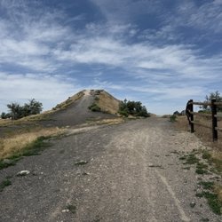
Lex Kunau Park Photos


More like Lex Kunau Park
Recommended Reviews - Lex Kunau Park
Start your review...

4 years ago
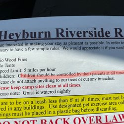
Beautiful riverside park. No specific dog areas. Lots of open grass with tables and bathrooms. read more
More info about Lex Kunau Park
100 Overland Ave
Burley, ID 83318
Directions
Hours
Outdoor Amenities


Lex Kunau Park - parks - Updated July 2026
Best of Burley
People found Lex Kunau Park by searching for…
Trending Searches in Burley, ID
Browse Articles
Browse Nearby
BEST of Burley, Idaho Things to Do near Lex Kunau Park
BEST of Burley, Idaho Coffee near Lex Kunau Park
BEST of Burley, Idaho Restaurants near Lex Kunau Park
BEST of Burley, Idaho Playgrounds near Lex Kunau Park
BEST of Burley, Idaho Walking Trails near Lex Kunau Park
BEST of Burley, Idaho Campgrounds near Lex Kunau Park
BEST of Burley, Idaho Breakfast near Lex Kunau Park
Browse Brands
Related Searches in Burley, ID
Best Fishing Locations and Guides in Burley, Idaho
Best Nature Trails for Hiking in Burley, Idaho
Best Places for Horseback Riding in Burley, Idaho
Best Places for Stunning Views in Burley, Idaho
Best Things to Do on a Rainy Day in Burley, Idaho
Best Water Parks for Kids in Burley, Idaho
Best Waterfalls and Swimming Holes in Burley, Idaho
Check Out Great Playgrounds in Burley, Idaho
Check Out Off Road Trails in Burley, Idaho
Discover Popular Bike Trails in Burley, Idaho
Discover Popular Photo Spots in Burley, Idaho
Discover Top Nature Parks to Visit in Burley, Idaho
Discover the Best Beaches in Burley, Idaho
Discover the Best Green Parks to Visit in Burley, Idaho
Enjoy Tent Camping Spots Around Burley, Idaho
Enjoy the Best Picnic Spots and Ideas in Burley, Idaho
Enjoy the Best Walking Trails in Burley, Idaho
Experience Stunning Sunset Views in Burley, Idaho
Explore Free Things to Do Around Burley, Idaho
Explore Landmarks & Historical Buildings in Burley, Idaho
Explore Nature Spots Around Burley, Idaho
Explore Popular Campgrounds Near Burley, Idaho
Explore Popular Picnic Areas Around Burley, Idaho
Explore Popular RV Parks Around Burley, Idaho
Explore Scenic Lakes to Visit in Burley, Idaho
Explore Top Gyms in Burley, Idaho Now
Explore Top Water Parks in Burley, Idaho Today
Family Friendly Hiking With Kids in Burley, Idaho
Find Beautiful Views in Burley, Idaho
Find Picnic Tables for Outdoor Fun in Burley, Idaho
Find Top-Rated Waterfalls in Burley, Idaho Now
Find the Best Parks for Picnics in Burley, Idaho
Find the Best Swimming Pools in Burley, Idaho Today
Great Places to Swim in Burley, Idaho
Locate a Public Shower Facility in Burley, Idaho
Must-See Tourist Attractions Around Burley, Idaho
Plan a Scenic Drive Route Near Burley, Idaho
Popular Fishing Spots to Explore in Burley, Idaho
Popular Kids Activities in Burley, Idaho
Popular Places to Take Pictures in Burley, Idaho
Popular Things to Do in Burley, Idaho
Relax at Natural Hot Springs Near Burley, Idaho
Safe River Swimming Areas in Burley, Idaho
Top Hiking Trails to Explore in Burley, Idaho