Kamanaiki Ridge Trail Photos


You might also consider
More like Kamanaiki Ridge Trail
Recommended Reviews - Kamanaiki Ridge Trail
Start your review...

Reviews With Photos

Very much enjoyed this trail today! We had planned to do the ice ponds but got rejected by security there. Kamanaiki was a backup but it sure was nice! The stairs at the beginning were a good cardio start up but not too difficult. Maybe 200 stairs? Then you'll pass the graffiti-covered water tank. Just keep going up. The views of Honolulu, the airport, and Kalihi valley are really nice the higher you go. I only went about 3/4 mile (30 minutes) up, then turned around and came back. I don't know how far this trail goes but next time I'll try to go to the end. It's shady most of the way. There are a few steep and slippery parts but I did okay with just my hiking shoes (not boots) and gloves. Boots would have been better for the slippery sections...

This trail starts at the end of a Dead End residential street. The trailhead is the stairs next to the house at the head of the street, it looks like they're part of the residence but they aren't. I went in September 2018 and the start of the stairs was pretty treacherous in dry conditions, they are littered with leaves and forest debris. It clears up a bit further, which made the stairs easy. I believe they would be quite hard when wet though, there are little to no handholds. Above, some minor climbing is required. But the views are nice once you get up.

Hidden Gem!!! I don't understand why this trail is rarely talked about or explored. Views, ridges, an old water tower, guava and mango trees, and a waterfall! We started off with the intention of doing the ridge, but the waterfall called our names! If you decide to do the waterfall, be prepared with spikes, mosquito spray, lots of water, gloves and for lots of stream crossings and for a long climb back to the trail. It's only 3 miles round trip but my friends and I--all distant hikers with great stamina--kept swearing at the hill! Lol You may also want to bring extra ribbon; the trail is ribboned but there were a few times that we got turned around. Trek on Yelpers!


Finally did this trail which literally in my neighborhood. It was hard to find at first. I followed the address provided in Yelp. Come to find out it was not the address the accurate address. The trail can be found in Manaiki Place, which I submitted a geotag in Google. I went up early and it was chilly for the most part. The stairs, is only at the beginning, and the rest are trail. There's a lot of marker along the trail so it's impossible to get lost. Houses are visible down the valley until you hike further up. I noticed the LikeLike Highway become also visible after a while and as I hike further up. I never had issue on bugs, mosquito nor fruit flies while hiking; so maybe it could be on the weather or time of that day. The trail is pretty much covered, so not much a worry for those who are avoiding to get tan or sunburn. I feel like I didn't finish the trail. I reached the place where the path ends and a boulder which was by the cliff. I chose not to continue as a I was hiking alone. It kinda looks scary and sketchy. I wish to see what's on the other side of those boulder someday, I'll just have to come back with someone. Highly recommended for a good and quick hike.

Off the beaten path! This trail is quite hidden. It's unmarked, and the entrance is in a residential cup-de-sac. For details on how to find it, go here: http://www.explorationhawaii.com/2011/09/18/kamanaiki-ridge-trail-views-from-kalihi-valley/ Parking: Residential street parking only. Be kind to the residents, as these families have been here for decades. A resident gave me "what are you doing on my street?" look, so I kindly asked her if it was okay to park there. She asked where I was going, so I said, "Hiking." And, she gave me the go-ahead hand signal. (Don't leave valuables visible in car.) Hike ambiance: As a woman, I would never do this hike alone because it's so woodsy and secluded. But, with at least one buddy, it's pretty safe. With a group, it's great! You have to enter through a shrubby, over-grown narrow stairway so do wear BUG spray! After that, you walk through a well-kept path that runs through pine trees, eucalyptus trees, and all kinds of tropical shrubs. In the late summer, you can pick strawberry guava, which tastes like strawberry-pineapple goodness. There's a graffiti covered water tower which is fun to explore. Keep going to the tippy top and there's a great lookout point with wonderful views of Kalihi Valley. Bring water as it can get hot but a gentle breeze often rolls through the trees. Overall: I'd say this hike is almost as intense as Koko Head but a lot more shaded and nature-y! A great place to have a reflective, meditative, yet invigorating hike! I've seen rainbows on this hike 2 out of 4 times! Then, treat yourself for food at Kamehameha Shopping Center, Helena's, or Chinatown!

Kamanaiki cardio!! I joined HTMC one fine morning to see this trail. It was a weekend and the battle of sleeping in almost won that day I'm so glad I got up and out early to see this with my own soul!!! So you begin headed up stairs and uphill for the majority of the start. PUSH IT!! Don't stop...move that okole and get up that ridge. I adore ridges and my home is Makakilo so I endure uphill workouts. I tell you...life changer The rest....I'm no spoiler alert....get up there and go see for your self Views....if you know your Pu'u (peaks) you should be able to see hind-side of Lanipo and your Valleys For me it was a humm I wonder what's over there? As I drive down the Likelike.....question answered Happy trails

Hard to find, but if you're using Google Maps or any GPS look for these directions and then park near the Water Supply nearby. You'll walk up a steep road and these stairs that are next to a house. Parking can be difficult but there is parking on side streets nearby. Make sure you bring at least a bottle of water and bug spray, although the bugs weren't too bad. I recommend shoes, not flip flops. The trail can be steep at some areas and muddy at others (but not too muddy). We didn't see anyone when we hiked it on a Sunday afternoon and it took us about 2 hours round trip. However, we did not go all the way. Once we started going down the other side of the mountain we decided to turn back. The trail can get narrow at times, steep, and at least once you have to use all fours. There are a few nice views that only the eye can truly appreciate. (It's hard for cameras to capture the beauty, my photos won't do justice.) It's a physically demanding trail, but you can do it!

This is for the ridge hike not the waterfall. I like that there were no other hikers on this hike. It reminds me of Waahila Ridge in difficulty and views. It is definitely an Intermediate hike. There is about 80% tree cover thankfully or it would be even more hotter. I drank almost 2L of water roundtrip. Spikes came in handy for most of the hike. Really nice views the entire time, good workout. Only downfall is lack of parking. Be careful not to park on concrete fronting houses. They look like steeet parking but you'll get note from homeowner on your windshield. Took 3.5 hrs total for 4.2 miles including short breaks

Good hike, a lot longer than I expected. I hiked for over an hour and didn't see the waterfall. I unfortunately was on a time schedule, and would have loved to go farther. Beautiful trees, and views once you get to the top of the ridge. The trail can be over grown at some parts. You can tell not many people hike it. I have been told in that valley that are deer, and unfortunately pigs. So be alert. The stairs at the beginning sucked but it's good cardio. It does look like your going into someone's backyard, but the stair continue after the house. Kind-of hard to find parking.

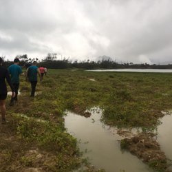
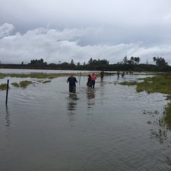
Did this hike today and OMG what a terrifying experience. Let me start from the beginning. To get here take likelike highway and take a right onto Nalanieha street. Then take a left onto Kalihi street and then a quick right onto Manaiki plaza. You will want to park somewhere in the neighborhood. So walk up Manaiki PI to the back where I believe the house address is 1801 Manaiki PI. You want to take the concrete stairs that look like they are leading up to the houses front porch but your instantly immersed in the forest. You walk up over 50 concrete stairs and soon you will reach a water tank covered in graffiti. You want to keep the water tank to your left and you'll see a trail going up. Continue to take the trail, which is well marked with pink ribbons throughout. You will come across many Christmas berry trees, guava bushes, iron wood trees, etc. as you get further to the end of the hike, the trail becomes narrow and you will have to climb a steep section, which can be quite muddy, but if you look to the left there is a rope for assistance. You reach the end when you get to a grassy flat wider area, sorry hard to describe, with views all around. So this part of the trail was actually enjoyable, but being adventurous and not yet fulfilled, I had decided to take the loop version of this hike instead of just doing the 'out and back' version, which is the route most people take. So at the end of the approx 2.5 mile hike to the top, I decided to take the trail on the right, also marked with ribbons which leads to the Kamanaiki stream. On this path you take a downward sloping path through a sea of uluhe- you may have actually seen this trail while hiking up- it was on the right hand side going up and it looks like a canal going down a small mountain. BUT the uluhe, which cushioned each step, quickly turned to mud and it left me no choice but to almost crawl down, especially since there were 50+ foot drops to my side. It had been raining during about 70% of the hike so I'm not sure if it's always this difficult but on this hike it was. After about 10 minutes I made it to the stream, which you have to cross. If you go slightly down to the right following the stream down, you will notice your standing on a waterfall. Unfortunately, you don't get to see the falls from below, or else I was just unable to find the path. So I continued to follow the pink ribbons, and follow them, and follow them some more for what seemed like forever- granted I was falling and crawling in mud for the vast majority of the time. Then, the ribbons just stopped, even though I stayed on the well defined trail. At this point it was getting late and I knew if I turned around I would still be on the trail well past sunset, so I decided to press my luck. I climbed under trees and fell a few times in the mud. I was starting to lose hope, but I knew if I continued to follow the stream down, I would eventually run into the neighborhood. Finally after 3 hours from the top of the hike, I came across someone's backyard, which I had to climb up a muddy hill to access. I was then able to walk a mile back to my starting location. I'm not sure if the hike to Kamanaiki stream is always this rough but quickly after starting the loop trail I regretted it. I could hear a few waterfalls and catch glimpses of them from the trail but I'd much rather be sitting under them relaxing than worrying about making it safely back to my starting point. Tips: Do the hike as an OUT AND BACK- meaning don't follow the trail to the stream!!!!!! Bring mosquito repellent

I'd say the beginning is the best part. The stairs at the start are quite charming, and you quickly get some views of Kalihi valley with the ocean behind it. There are some guava forests - though no guava were growing in July when I went. After a certain point, the hike stops having any new views, but it still remains pleasant. I did about 6 miles roundtrip. I wasn't sure where the ending point was supposed to be and eventually just turned around, which was a little anticlimatic.

Very much enjoyed this trail today! We had planned to do the ice ponds but got rejected by security there. Kamanaiki was a backup but it sure was nice! The stairs at the beginning were a good cardio start up but not too difficult. Maybe 200 stairs? Then you'll pass the graffiti-covered water tank. Just keep going up. The views of Honolulu, the airport, and Kalihi valley are really nice the higher you go. I only went about 3/4 mile (30 minutes) up, then turned around and came back. I don't know how far this trail goes but next time I'll try to go to the end. It's shady most of the way. There are a few steep and slippery parts but I did okay with just my hiking shoes (not boots) and gloves. Boots would have been better for the slippery sections... read more


8 years ago
This trail starts at the end of a Dead End residential street. The trailhead is the stairs next to the house at the head of the street, it looks like they're part of the residence but they aren't. I went in September 2018 and the start of the stairs was pretty treacherous in dry conditions, they are littered with leaves and forest debris. It clears up a bit further, which made the stairs easy. I believe they would be quite hard when wet though, there are little to no handholds. Above, some minor climbing is required. But the views are nice once you get up. read more


Hidden Gem!!! I don't understand why this trail is rarely talked about or explored. Views, ridges, an old water tower, guava and mango trees, and a waterfall! We started off with the intention of doing the ridge, but the waterfall called our names! If you decide to do the waterfall, be prepared with spikes, mosquito spray, lots of water, gloves and for lots of stream crossings and for a long climb back to the trail. It's only 3 miles round trip but my friends and I--all distant hikers with great stamina--kept swearing at the hill! Lol You may also want to bring extra ribbon; the trail is ribboned but there were a few times that we got turned around. Trek on Yelpers! read more


6 years ago
Take the bus. Drops you off really close to the trailhead. There is a sign and chain that says the trail is closed. Walk around it to the left and climb about 165 steps plus some uphill grades. You get to a graffiti painted water tank. The the fun starts. read more

9 years ago
Finally did this trail which literally in my neighborhood. It was hard to find at first. I followed the address provided in Yelp. Come to find out it was not the address the accurate address. The trail can be found in Manaiki Place, which I submitted a geotag in Google. I went up early and it was chilly for the most part. The stairs, is only at the beginning, and the rest are trail. There's a lot of marker along the trail so it's impossible to get lost. Houses are visible down the valley until you hike further up. I noticed the LikeLike Highway become also visible after a while and as I hike further up. I never had issue on bugs, mosquito nor fruit flies while hiking; so maybe it could be on the weather or time of that day. The trail is pretty much covered, so not much a worry for those who are avoiding to get tan or sunburn. I feel like I didn't finish the trail. I reached the place where the path ends and a boulder which was by the cliff. I chose not to continue as a I was hiking alone. It kinda looks scary and sketchy. I wish to see what's on the other side of those boulder someday, I'll just have to come back with someone. Highly recommended for a good and quick hike. read more

8 years ago
Off the beaten path! This trail is quite hidden. It's unmarked, and the entrance is in a residential cup-de-sac. For details on how to find it, go here: http://www.explorationhawaii.com/2011/09/18/kamanaiki-ridge-trail-views-from-kalihi-valley/ Parking: Residential street parking only. Be kind to the residents, as these families have been here for decades. A resident gave me "what are you doing on my street?" look, so I kindly asked her if it was okay to park there. She asked where I was going, so I said, "Hiking." And, she gave me the go-ahead hand signal. (Don't leave valuables visible in car.) Hike ambiance: As a woman, I would never do this hike alone because it's so woodsy and secluded. But, with at least one buddy, it's pretty safe. With a group, it's great! You have to enter through a shrubby, over-grown narrow stairway so do wear BUG spray! After that, you walk through a well-kept path that runs through pine trees, eucalyptus trees, and all kinds of tropical shrubs. In the late summer, you can pick strawberry guava, which tastes like strawberry-pineapple goodness. There's a graffiti covered water tower which is fun to explore. Keep going to the tippy top and there's a great lookout point with wonderful views of Kalihi Valley. Bring water as it can get hot but a gentle breeze often rolls through the trees. Overall: I'd say this hike is almost as intense as Koko Head but a lot more shaded and nature-y! A great place to have a reflective, meditative, yet invigorating hike! I've seen rainbows on this hike 2 out of 4 times! Then, treat yourself for food at Kamehameha Shopping Center, Helena's, or Chinatown! read more


10 years ago
Kamanaiki cardio!! I joined HTMC one fine morning to see this trail. It was a weekend and the battle of sleeping in almost won that day I'm so glad I got up and out early to see this with my own soul!!! So you begin headed up stairs and uphill for the majority of the start. PUSH IT!! Don't stop...move that okole and get up that ridge. I adore ridges and my home is Makakilo so I endure uphill workouts. I tell you...life changer The rest....I'm no spoiler alert....get up there and go see for your self Views....if you know your Pu'u (peaks) you should be able to see hind-side of Lanipo and your Valleys For me it was a humm I wonder what's over there? As I drive down the Likelike.....question answered Happy trails read more

Hard to find, but if you're using Google Maps or any GPS look for these directions and then park near the Water Supply nearby. You'll walk up a steep road and these stairs that are next to a house. Parking can be difficult but there is parking on side streets nearby. Make sure you bring at least a bottle of water and bug spray, although the bugs weren't too bad. I recommend shoes, not flip flops. The trail can be steep at some areas and muddy at others (but not too muddy). We didn't see anyone when we hiked it on a Sunday afternoon and it took us about 2 hours round trip. However, we did not go all the way. Once we started going down the other side of the mountain we decided to turn back. The trail can get narrow at times, steep, and at least once you have to use all fours. There are a few nice views that only the eye can truly appreciate. (It's hard for cameras to capture the beauty, my photos won't do justice.) It's a physically demanding trail, but you can do it! read more


This is for the ridge hike not the waterfall. I like that there were no other hikers on this hike. It reminds me of Waahila Ridge in difficulty and views. It is definitely an Intermediate hike. There is about 80% tree cover thankfully or it would be even more hotter. I drank almost 2L of water roundtrip. Spikes came in handy for most of the hike. Really nice views the entire time, good workout. Only downfall is lack of parking. Be careful not to park on concrete fronting houses. They look like steeet parking but you'll get note from homeowner on your windshield. Took 3.5 hrs total for 4.2 miles including short breaks read more

8 years ago
Good hike, a lot longer than I expected. I hiked for over an hour and didn't see the waterfall. I unfortunately was on a time schedule, and would have loved to go farther. Beautiful trees, and views once you get to the top of the ridge. The trail can be over grown at some parts. You can tell not many people hike it. I have been told in that valley that are deer, and unfortunately pigs. So be alert. The stairs at the beginning sucked but it's good cardio. It does look like your going into someone's backyard, but the stair continue after the house. Kind-of hard to find parking. read more


11 years ago
Did this hike today and OMG what a terrifying experience. Let me start from the beginning. To get here take likelike highway and take a right onto Nalanieha street. Then take a left onto Kalihi street and then a quick right onto Manaiki plaza. You will want to park somewhere in the neighborhood. So walk up Manaiki PI to the back where I believe the house address is 1801 Manaiki PI. You want to take the concrete stairs that look like they are leading up to the houses front porch but your instantly immersed in the forest. You walk up over 50 concrete stairs and soon you will reach a water tank covered in graffiti. You want to keep the water tank to your left and you'll see a trail going up. Continue to take the trail, which is well marked with pink ribbons throughout. You will come across many Christmas berry trees, guava bushes, iron wood trees, etc. as you get further to the end of the hike, the trail becomes narrow and you will have to climb a steep section, which can be quite muddy, but if you look to the left there is a rope for assistance. You reach the end when you get to a grassy flat wider area, sorry hard to describe, with views all around. So this part of the trail was actually enjoyable, but being adventurous and not yet fulfilled, I had decided to take the loop version of this hike instead of just doing the 'out and back' version, which is the route most people take. So at the end of the approx 2.5 mile hike to the top, I decided to take the trail on the right, also marked with ribbons which leads to the Kamanaiki stream. On this path you take a downward sloping path through a sea of uluhe- you may have actually seen this trail while hiking up- it was on the right hand side going up and it looks like a canal going down a small mountain. BUT the uluhe, which cushioned each step, quickly turned to mud and it left me no choice but to almost crawl down, especially since there were 50+ foot drops to my side. It had been raining during about 70% of the hike so I'm not sure if it's always this difficult but on this hike it was. After about 10 minutes I made it to the stream, which you have to cross. If you go slightly down to the right following the stream down, you will notice your standing on a waterfall. Unfortunately, you don't get to see the falls from below, or else I was just unable to find the path. So I continued to follow the pink ribbons, and follow them, and follow them some more for what seemed like forever- granted I was falling and crawling in mud for the vast majority of the time. Then, the ribbons just stopped, even though I stayed on the well defined trail. At this point it was getting late and I knew if I turned around I would still be on the trail well past sunset, so I decided to press my luck. I climbed under trees and fell a few times in the mud. I was starting to lose hope, but I knew if I continued to follow the stream down, I would eventually run into the neighborhood. Finally after 3 hours from the top of the hike, I came across someone's backyard, which I had to climb up a muddy hill to access. I was then able to walk a mile back to my starting location. I'm not sure if the hike to Kamanaiki stream is always this rough but quickly after starting the loop trail I regretted it. I could hear a few waterfalls and catch glimpses of them from the trail but I'd much rather be sitting under them relaxing than worrying about making it safely back to my starting point. Tips: Do the hike as an OUT AND BACK- meaning don't follow the trail to the stream!!!!!! Bring mosquito repellent read more


7 years ago
11 years ago
I'd say the beginning is the best part. The stairs at the start are quite charming, and you quickly get some views of Kalihi valley with the ocean behind it. There are some guava forests - though no guava were growing in July when I went. After a certain point, the hike stops having any new views, but it still remains pleasant. I did about 6 miles roundtrip. I wasn't sure where the ending point was supposed to be and eventually just turned around, which was a little anticlimatic. read more


12 years ago
8 years ago
10 years ago
The trail is pretty easy to follow. Their a lot of stairs to walk up so basically your walking upwards. It reminded me of "Koko Head" but theirs a lot shade. Only made it up to the water tower!! This hike is pretty easy for a beginner hiker like me. I would do this hike again.. And it's convenient if you live in the Kalihi area.. read more


10 years ago
8 years ago
More info about Kamanaiki Ridge Trail
1730 Violet St
Honolulu, HI 96819
Directions
Hours
Outdoor Amenities
Ask the Community - Kamanaiki Ridge Trail
Review Highlights - Kamanaiki Ridge Trail
You might also consider


Kamanaiki Ridge Trail - climbing - Updated May 2026
Best of Honolulu
People found Kamanaiki Ridge Trail by searching for…
Climbing Gym in Honolulu, Hawaii
Rock Climbing in Honolulu, Hawaii
Hiking Trails in Honolulu, Hawaii
Waterfall Hike in Honolulu, Hawaii
Hiking Shoes in Honolulu, Hawaii
Stair Climbing in Honolulu, Hawaii
Waterfalls in Honolulu, Hawaii
Dog Friendly Hiking Trails in Honolulu, Hawaii
Bouldering in Honolulu, Hawaii
Hiking Club in Honolulu, Hawaii
Bouldering Gym in Honolulu, Hawaii
Walking Trails in Honolulu, Hawaii
Scenic Overlook in Honolulu, Hawaii
Indoor Rock Climbing for Kids in Honolulu, Hawaii
Indoor Sports in Honolulu, Hawaii
Things to Do in Honolulu, Hawaii
Running Trails in Honolulu, Hawaii
Cliff Jumping in Honolulu, Hawaii
Trending Searches in Honolulu, HI
Boat Rental near Kamanaiki Ridge Trail
Botanical Gardens near Kamanaiki Ridge Trail
Bounce House Rentals near Kamanaiki Ridge Trail
Campgrounds near Kamanaiki Ridge Trail
Cherry Picking near Kamanaiki Ridge Trail
Flower Shop near Kamanaiki Ridge Trail
Garage Sales near Kamanaiki Ridge Trail
Hair near Kamanaiki Ridge Trail
Nurseries & Gardening near Kamanaiki Ridge Trail
Outdoor Furniture Stores near Kamanaiki Ridge Trail
Party Equipment Rentals near Kamanaiki Ridge Trail
Pedicure near Kamanaiki Ridge Trail
Pick Your Own Farms near Kamanaiki Ridge Trail
Browse Articles
Browse Nearby
BEST of Honolulu, Hawaii Coffee near Kamanaiki Ridge Trail
BEST of Honolulu, Hawaii Restaurants near Kamanaiki Ridge Trail
BEST of Honolulu, Hawaii Things to Do near Kamanaiki Ridge Trail
BEST of Honolulu, Hawaii Hiking near Kamanaiki Ridge Trail
BEST of Honolulu, Hawaii Trampoline Parks near Kamanaiki Ridge Trail
BEST of Honolulu, Hawaii Breakfast near Kamanaiki Ridge Trail
BEST of Honolulu, Hawaii Camping near Kamanaiki Ridge Trail
BEST of Honolulu, Hawaii Sightseeing near Kamanaiki Ridge Trail
BEST of Honolulu, Hawaii Whale Watching near Kamanaiki Ridge Trail
Browse Brands
Related Searches in Honolulu, HI
Best Gymnastics for Kids Activities in Honolulu, Hawaii
Best Places for Calisthenics Workouts in Honolulu, Hawaii
Best Places for Exercise and Fitness in Honolulu, Hawaii
Challenge Yourself With an Obstacle Course in Honolulu, Hawaii
Discover Exciting Adventure Options in Honolulu, Hawaii
Discover Fun Activities to Do in Honolulu, Hawaii
Discover Great Fitness Classes Available in Honolulu, Hawaii
Discover Popular Ropes Course Options in Honolulu, Hawaii
Discover Top Yoga Options and Studios in Honolulu, Hawaii
Enjoy Hiking Adventures in Honolulu, Hawaii
Enjoy the Best Bouldering Experiences in Honolulu, Hawaii
Experience Aerial Yoga Sessions in Honolulu, Hawaii
Experience Ninja Warrior Challenges in Honolulu, Hawaii
Explore Fitness Centers and Gyms in Honolulu, Hawaii
Explore Fun Activities to Do in Honolulu, Hawaii
Explore Martial Arts Options in Honolulu, Hawaii
Explore Top Parkour Spots and Activities in Honolulu, Hawaii
Explore the Best Rock Climbing Areas in Honolulu, Hawaii
Find Fun Kids Activities Outdoor in Honolulu, Hawaii
Find Popular Ziplining Spots Around Honolulu, Hawaii
Find Top Jiu Jitsu Classes and Training in Honolulu, Hawaii
Find Top Kickboxing Options in Honolulu, Hawaii
Find Top Tai Chi Sessions in Honolulu, Hawaii
Find Top Workout Classes Available in Honolulu, Hawaii
Find the Best Boxing Training and Gyms in Honolulu, Hawaii
Find the Best Climbing Wall Options in Honolulu, Hawaii
Find the Best Cycling Classes in Honolulu, Hawaii
Find the Best Trampoline Spots in Honolulu, Hawaii
Fun Indoor Activities to Try in Honolulu, Hawaii
Indoor Playgrounds to Visit in Honolulu, Hawaii
Join Popular Zumba Sessions in Honolulu, Hawaii
Popular Kids Activities in Honolulu, Hawaii
Popular Outdoor Activities to Try in Honolulu, Hawaii
Popular Workout Locations in Honolulu, Hawaii
Quality Climbing Gear Available in Honolulu, Hawaii
Rock Climbing Activities for Kids in Honolulu, Hawaii
Safe Jumping Activities for Kids in Honolulu, Hawaii
Safe and Fun Kids Gym Facilities in Honolulu, Hawaii
Tennis Courts and Clubs Near Honolulu, Hawaii
Top Canyoneering Adventures Available in Honolulu, Hawaii
Top Crossfit Gyms and Classes in Honolulu, Hawaii
Top Hiking Trails to Explore in Honolulu, Hawaii
Top Muay Thai Training and Gyms in Honolulu, Hawaii
Top Outdoor Rock Climbing Spots in Honolulu, Hawaii
Top Paddleboarding Activities in Honolulu, Hawaii
Top Swimming Spots and Pools in Honolulu, Hawaii
Top-Rated Gymnastics Programs in Honolulu, Hawaii
Visit Premier Bouldering Gyms in Honolulu, Hawaii
People who viewed Kamanaiki Ridge Trail also viewed
Kawainui Neighborhood Park
3 reviews
Oneawa Hills
17 reviews
Koko Head District Park
393 reviews
Friendship Garden
75 reviews
Aiea Loop Trail
322 reviews
Judd Trail
105 reviews
Moanalua Valley Trail
70 reviews
Kulepeamoa Ridge Hike
9 reviews
Niu Valley
Pu'u Ma'eli'eli Digging Hill
116 reviews
Makiki Valley Trail
120 reviews