Cancel

    Open app

    Search

    Insel Ufenau Photos

    Insel Ufenau Reviews in Other Languages

    Verify this business for free

    Get access to customer & competitor insights.

    Verify this business

    Stoos

    Stoos

    4.4(5 reviews)
    25.6 km

    A must on your do to list. Hiking boots, water bottle and sunscreen. Enjoy the view it's just truly…read morea beautiful place. Tip: Take the funicular up, hike the Stoos to the end and take the chairlift down.

    The Stoos Ridge Hike was another trail I planned my Switzerland trip around. Social media really…read moremade this ridge hike popular with the phenomenal views of the Alps and 10 different lakes. If possible, try staying overnight at Gipfelrestaurant Fronalpstock for the best experience. It was quite the journey getting to the beginning of the trail from Lucerne. We had to take the train, a bus, then the world's steepest funicular, and finally a cable car. And if you're not spending the night in the area, make sure you begin your day early so you can catch the last cable car down the mountain after hiking. Harcore hikers can choose to skip the cable car but if you plan on taking the same transportation, look into the Stoos passes, which is also discounted with the Swiss Pass or Half Pass! Out of every hike we did during our trip, I would rate this the hardest. Not only were the steep parts really steep, it was also very hot and sunny. There were also a ton of flies and beetles so we were constantly moving to avoid them, giving us little time for breaks. And because we came from Lucerne, we arrived kind of late and there were already a lot of people on the trails. But the views are amazing and I stayed there overnight and got to see the sunset. It's best to hike this from Klingenstock to Fronalpstock so that you can end the hike at the restaurant and grab a couple of beers to enjoy the view. There's also some playgrounds for the younger kids and a gated area to enter and pet some miniature goats. If you go the other way, there isn't much of an area to chill at Klingenstock and you would just have to go back down the mountain. Overall, glad I got to do it once but it's a rough one to hike during the summer. The views were amazing though and being able to stay up there when it's empty was a nice experience.

    Photos
    Stoos
    Stoos
    Stoos

    See all

    Schanzengraben - The section of the Schanzengraben closest to the Zurich lake.

    Schanzengraben

    4.0(3 reviews)
    25.2 kmKreis 1

    If you are relatively new to Zurich, it might be tough at times to recognize which river is which…read more So let's start sorting through the confusion by pointing out which body of water is technically NOT a river, but a canal that was used as the outer moat outside the Zurich city walls starting in 1642: the Schanzengraben. The easiest place to spot it is just off Bürkliplatz, to the left of the Bar Au Lac, and that's where I'd recommend beginning your walk. 
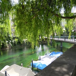
Walking alongside the canal, you will likely be surprised at how quickly the noise starts fading, even though you are in the middle of the city. And don't worry if you cannot recognize your surroundings - you are still in the center of Zurich, I promise! Walking along the Schanzengraben's zig-zag course you will cross Dreikönigstrasse, Bleicherweg, Gartenstrasse...When you get to the Selnau Bridge, you may choose to take a break to check out the Old Botanic Garden, or keep walking past it. Right past the Old Botanic Garden is where you can see the old Zurich walls that the Schanzengraben was created to protect. Shortly after you will find an old "Männerbad" (men's bathing house) which is still in operation; by night it turns into the Rimini Bar (and then it's open to everyone!). Right next to it there is a charming old windmill. Keep walking 10 more minutes, and you will get to a spot you will likely recognize: right behind the Migros City, where you might have even stopped to eat your lunch now and again. Just 100 meters or so beyond that point the Schanzengraben ends, by joining the Sihl river. The whole walk could be done in 35-40 minutes, but it's much nicer to take your time and enjoy the peace quiet and a few hidden spots you may not have noticed from the main streets :-) It's a charming walk and I would especially recommend it in late spring and early fall, when it's all green and in bloom around the canal.

    Photos
    Schanzengraben - The Schenzengraben, taken while approaching the Selnau Bridge.

    The Schenzengraben, taken while approaching the Selnau Bridge.

    Schanzengraben

    See all

    Insel Ufenau - hiking - Updated May 2026

    Loading...
    Loading...
    Loading...