I-90 Vantage Bridge Photos


More like I-90 Vantage Bridge
Recommended Reviews - I-90 Vantage Bridge
Start your review...

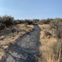
heading down to the coast for a night of racing and come upon this ridiculous thing in the middle of the desert. don't get me wrong, I've bridged up here a lot but this span is in its own league entirely... besides being a half-mile long ramp across the river it's got twisty turns on the other end feeding in or leading out or just driving past on Rte 26 heading to Tacoma and by the time I realize how cool it is there's no place to pull over and have a look until next time (getting turned around counts as next time) and realizing there's way too many spots to get a better look at the bridge and sometimes it takes two or several passes which is kind of a good problem to have... totally digging the man-gates on the richland side; the stunted brush and broken terrain brings odd notions about what went on here before the fences got staked... enjoy :-) read more


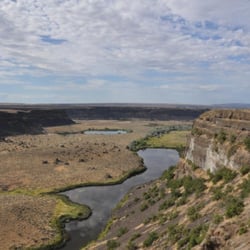
Holy smokes, what a great view! But holy smokes, the wind nearly blew me off the bridge! The Vantage Bridge is the second one at this location, which carries Interstate 90 over the Columbia River and joins Vantage with George (and who was clever to name their town George in the state of Washington?). This section of the river is the Wanapum Lake that is formed by the Wanapum Dam that you can't see from the bridge but it's there. This type of bridge is a "through arch bridge" and it has a total length of 2504 feet. It was dedicated in 1962 and is in great condition considering it is 60 years old. There is a "scenic view" spot on the east bank where you can get a great view of the bridge. It was so windy up there that I could barely stand! [Review 17107 overall - 95 in Washington - 623 of 2022.] read more


Many of the bridges which cross the Columbia are bits of engineering marvels. What sets this bridge apart is location, location, location. The Columbia river gorge in this section of the river is pretty spectacular. Sometimes I have to slow down from 70mph to truly soak in the beautiful scenery here. Whether you're heading to Seattle, a show at The Gorge upriver, or down to the river to play in the water, this funky fresh bridge close to the center of WA is a true landmark. read more

11 years ago
More info about I-90 Vantage Bridge


Why does Yelp recommend reviews?
1 review that is not currently recommended
The reviews below are not factored into the business's overall star rating.
8 years ago
I-90 Vantage Bridge - landmarks - Updated May 2026
Best of Vantage
People found I-90 Vantage Bridge by searching for…
Things to Do in Vantage, Washington
Scenic View in Vantage, Washington
View Points in Vantage, Washington
Parking in Vantage, Washington
Places to Take Pictures in Vantage, Washington
Scenic Spots in Vantage, Washington
Museums in Vantage, Washington
Things to Do at Night in Vantage, Washington
Photo Spots in Vantage, Washington
Watch Sunset in Vantage, Washington
Sunset View in Vantage, Washington
Libraries in Vantage, Washington
Scenic Drive in Vantage, Washington
Hiking Trails in Vantage, Washington
Tourist Attractions in Vantage, Washington
Night View in Vantage, Washington
Beautiful Views in Vantage, Washington
Monastery in Vantage, Washington
Points of Interest in Vantage, Washington
Parks for Pictures in Vantage, Washington
Trending Searches in Vantage, WA
Browse Articles
Browse Nearby
BEST of Vantage, Washington Restaurants near I-90 Vantage Bridge
BEST of Vantage, Washington Things to Do near I-90 Vantage Bridge
BEST of Vantage, Washington Photo Spots near I-90 Vantage Bridge
BEST of Vantage, Washington Coffee near I-90 Vantage Bridge
BEST of Vantage, Washington Museums near I-90 Vantage Bridge
BEST of Vantage, Washington Hotels near I-90 Vantage Bridge
BEST of Vantage, Washington Campgrounds near I-90 Vantage Bridge
BEST of Vantage, Washington Breakfast near I-90 Vantage Bridge
Browse Brands
Related Searches in Vantage, WA
Beautiful Flower Fields in Vantage, Washington
Best Fishing Locations and Guides in Vantage, Washington
Best Lookout Points to Visit in Vantage, Washington
Best Places for Stunning Views in Vantage, Washington
Best Spots for Star Gazing in Vantage, Washington
Best Waterfalls and Swimming Holes in Vantage, Washington
Discover Charming Historic Homes in Vantage, Washington
Discover Popular Landmarks in Vantage, Washington
Discover Romantic Views in Vantage, Washington
Discover Top Nature Parks to Visit in Vantage, Washington
Discover the Best Beaches in Vantage, Washington
Discover the Best Caves to Explore in Vantage, Washington
Discover the Best Night Hike Trails in Vantage, Washington
Enjoy Hiking Adventures in Vantage, Washington
Enjoy Scenic Night View Experiences in Vantage, Washington
Enjoy the Best Night View Spots in Vantage, Washington
Enjoy the Best Walking Trails in Vantage, Washington
Experience Stunning Sunset Views in Vantage, Washington
Explore Beautiful Castles and Landmarks in Vantage, Washington
Explore Beautiful Parks and Green Spaces in Vantage, Washington
Explore Free Picnic Areas Around Vantage, Washington
Explore Nature Spots Around Vantage, Washington
Explore Popular Scenic Overlook Points in Vantage, Washington
Explore Popular View Points Around Vantage, Washington
Explore Scenic Lakes to Visit in Vantage, Washington
Explore Scenic National Park Locations in Vantage, Washington
Explore Secret Spots Worth Visiting in Vantage, Washington
Explore Venues & Event Spaces in Vantage, Washington
Explore Vibrant Public Art Displays in Vantage, Washington
Explore the Best Trail Options in Vantage, Washington
Explore the Rich History in Vantage, Washington
Find Top-Rated Waterfalls in Vantage, Washington Now
Find the Best Bridge Spots in Vantage, Washington
Find the Best Playgrounds to Visit in Vantage, Washington
Get Your City Pass for Attractions in Vantage, Washington
Must-See Tourist Attractions Around Vantage, Washington
Perfect Spots to Watch Sunset in Vantage, Washington
Popular Picnic Spots to Visit in Vantage, Washington
Popular Places to Walk Around in Vantage, Washington
Popular Things to Do in Vantage, Washington
Popular Things to See in Vantage, Washington
Relax at Natural Hot Springs Near Vantage, Washington
Secure Convenient Parking Options in Vantage, Washington
Stair Climbing Activities and Gyms in Vantage, Washington
Top Hiking Trails to Explore in Vantage, Washington
Top Things to Do With Teenagers in Vantage, Washington
Tour Famous Lighthouses Located in Vantage, Washington
Visit Popular Museums in Vantage, Washington Now