Handy Pond Preserve Photos


You might also consider
More like Handy Pond Preserve
Recommended Reviews - Handy Pond Preserve
Start your review...

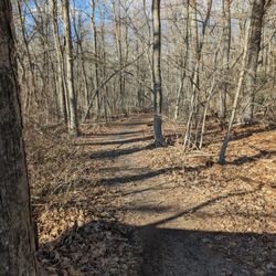
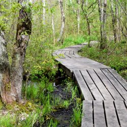
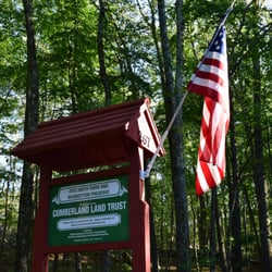
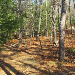
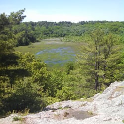
Located between Albion and Manville in Lincoln, Rhode Island, this preserve is a convenient place to stretch your legs and get a couple miles in. Relatively easy terrain with some decent ups and downs, the trails here are pretty open and follow the remnants of old cart paths and stone walls. Great views of Rochambeau Pond where largemouth bass and trout fishing is the popular activity. Greenery is in full swing at the moment (as well as the bugs). Some nice open areas within the woods where you can look out over the outcropping of rocks. Came across a small unmarked cemetery, a typical Rhode Island hike find. No markings on the stones though so I'm not sure if it's considered a small family plot or has some other kind of history. I was happy to have a GPS mapping system because the available maps and blaze system here were a little all over the place. Multiple colors and oddly placed markings. The trails are very obvious but do branch off in all different directions. The bridges here could use some updating, one was very bouncy as I gingerly traversed it. There's a great deal of street noise from the neighboring RI-99. The trails pass through some major power lines which afforded some views. Overall, a decently picaresque hike in Rhode Island; a place I would visit for some exercise and varied terrain if I lived in the area. Small parking area with space for 3 or 4 cars. read more


More info about Handy Pond Preserve
2 Crestwood Ln
Lincoln, RI 02865
Directions
Hours
Outdoor Amenities


Handy Pond Preserve - hiking - Updated May 2026
Best of Lincoln
People found Handy Pond Preserve by searching for…
Fishing in Lincoln, Rhode Island
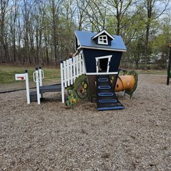
Playgrounds in Lincoln, Rhode Island
Walking Trails in Lincoln, Rhode Island
Hiking Trails in Lincoln, Rhode Island
Scenic View in Lincoln, Rhode Island
Running Trails in Lincoln, Rhode Island
Lakes & Ponds in Lincoln, Rhode Island
Fun Things to Do in Lincoln, Rhode Island
Waterfalls in Lincoln, Rhode Island
Beautiful Views in Lincoln, Rhode Island
Free Things to Do in Lincoln, Rhode Island
Tourist Attractions in Lincoln, Rhode Island
Easy Hikes in Lincoln, Rhode Island
Bike Paths in Lincoln, Rhode Island
Things to Do at Night in Lincoln, Rhode Island
What to Do in Lincoln, Rhode Island
Off Leash Dog Hikes in Lincoln, Rhode Island
Places to Visit in Lincoln, Rhode Island
Fall Foliage in Lincoln, Rhode Island
Stroller Friendly Hikes in Lincoln, Rhode Island
Fishing Spots in Lincoln, Rhode Island
Trail in Lincoln, Rhode Island
Browse Nearby
BEST of Lincoln, Rhode Island Restaurants near Handy Pond Preserve
BEST of Lincoln, Rhode Island Coffee near Handy Pond Preserve
BEST of Lincoln, Rhode Island Things to Do near Handy Pond Preserve
BEST of Lincoln, Rhode Island Parks near Handy Pond Preserve
BEST of Lincoln, Rhode Island Breakfast near Handy Pond Preserve
BEST of Lincoln, Rhode Island Lakes near Handy Pond Preserve
BEST of Lincoln, Rhode Island Hotels near Handy Pond Preserve
BEST of Lincoln, Rhode Island Sledding near Handy Pond Preserve
Browse Brands
Browse Articles
People who viewed Handy Pond Preserve also viewed
Westconnaug Meadows Hiking Trail
1 review
Otis Smith Farm and Rowbottom Preserve
2 reviews
Caratunk Wildlife Refuge
14 reviews
Lime Rock Nature Preserve
12 reviews
Wolf Hill Forest Preserve
21 reviews
Osamequin Wildlife Sanctuary
13 reviews
Martin Wildlife Refuge
1 review
Stillwater Scenic Trail
5 reviews
Canada Pond
1 review
Charles
Fenner Square
1 review