Glen Canyon Dam Bridge Photos


More like Glen Canyon Dam Bridge
Recommended Reviews - Glen Canyon Dam Bridge
Start your review...

Reviews With Photos

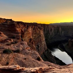
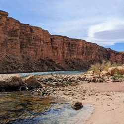
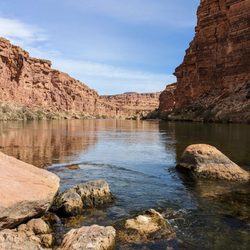
Just like the review for the dam .. its free to see ...if your in Page def go check out the dam and bridge. See other view from visitors center. If you dont have national park pass you can still see this without fee. If u have pass go further down the road to see other scenery. If we ever return would be interested in boat tour or renting boat to see the arch and look around. Water looked gorgeous and inviting on the hot day in early October.

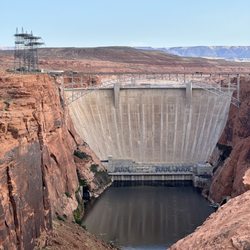
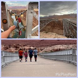
The views of the Glen Canyon Dam from this bridge are amazing. The Glen Canyon Bridge carries traffic from the U.S. Route 89 across the Colorado River. At around 700 feet, is the third highest bridge in Arizona behind the Mike O'Callaghan-Pat Tillman Memorial Bridge and the Grand Canyon Skywalk. The Glen Canyon Bridge is walkable and is about half a mile to walk from one side to the other and back. There is a visitor center nearby that you can park next to if you want to walk on the bridge. It is worth a 10 minute stop if you have some time.

I've never been through Page before so I wasn't expecting this massive bridge to unfold right in front of me as I drove exploring the area. It's mostly a motorway passage over the canyon but there is a sidewalk so you can walk across the bridge to take in the views of the dam or the canyon below. The bridge fencing is high (most likely for safety) but there are several cut outs in the bridge as you walk along so you can easily look through or stick a camera lens or your phone to take pictures (just make sure you're holding on tight, it's a looooong way down!). The bridge does shake if a large truck passes (which is often) so if you're afraid of heights you might not love that. I'm not and I still got a little freaked out the first time I felt it rumble! It's a bridge so there isn't really parking but there are some unmarked pull off areas to idle your car on one side, as well the visitor's center with parking on the other side. It's worth stopping and checking it all out though if you're driving through!

We were out visiting Antelope Canyon and drove into Lake Powell to check it out the day before. We saw this along the drive and stopped off to check it out. It is worth the quick little stop, there is parking on the side and the bridge speed limit is slow so you can cross the street easily. If you walk on the bridge, there is a fence and periodically there are small cutouts to take some photos. We really enjoyed it.

Glen Canyon Dam Bridge is basically trying to replicate the Navajo Bridge, except this is 99% for cars to drive over and does not offer you a good view of Glen Canyon and the Colorado River as the fencing goes really high. I *think* there might be a sidewalk on this, but with the fencing, it doesn't offer a good view of the dam by any means and is partially blocked by the visitor's center as well. Not pedestrian friendly for sure, more of just something to drive over on your way to the Glen Canyon Dam visitor center or in the other direction to the Glen Canyon overlook.

Such a beautiful bridge and dam that rises 710 feet within the steep, rust colored sandstone walls of Glen Canyon. We made a brief stop while on a day tour of this area and really enjoyed the views of both Lake Powell and the Colorado River. The bridge is made of all steel which makes one feel very secure when walking out on it which is a must when visiting. On one side your views feature the dam and Lake Powell for miles. On the opposite side, your views are of the powerful and stunning Colorado River. I appreciate the fact that even though the entire bridge is covered with a large fence on each side, there are still some small openings within the fencing to allow for some stunning pics and video. The visitor center is large and features spectacular views from large picture windows that are almost from floor to ceiling. In addition, there is a dam tour you can take, shop at the gift store or just enjoy the nice A/C for a moment or two while walking around and learning the history of the area. Overall a great stop!


I guess I'll write another Dam review, ok, really this is my first Dam review ... well I mean I've written reviews before, just never a Dam review...never mind I give up! This is really just a quick stop, especially since the visitor center is closed. But as you head into Page, AZ you cross across this massive bridge overlooking the dam. Pull off areas allow you to park and walk across the civilian portion of the bridge and grab some pics. Totally worth the Dam stop if you're in the area :)

Glen Canyon Dam Bridge can be found just a short distance from Glen Canyon Dam on U.S. 89 in Coconino County, Arizona. This" steel arch bridge" crosses over the Colorado River . The bridge was built on April, 1956 and had the distinction of being the 5th tallest bridge in the United States. Standing 700 feet tall ! Glen Canyon Dam/ Bridge & Lake Powell was our last stop of the day. Captivating a wonderful day of sight seeing !


Visiting the Glen Canyon Dam Bridge is an impressive experience. The engineering and scale of the bridge are truly remarkable, offering breathtaking views of the Colorado River and the surrounding canyon. Walking across the bridge gives you a unique perspective of the massive Glen Canyon Dam and the vast, rugged landscape. It's both a thrilling and contemplative experience, perfect for photography, sightseeing, or simply appreciating human ingenuity harmonized with nature. A must-see landmark for anyone exploring northern Arizona. read more


2 months ago
Cool place to stop to be able to see the dam, part of the lake, and to look down at the river when crossing the bridge. Very beautiful. read more


9 months ago
On our way to Horse shoe Bend and stopped to Visitor Info. Beautiful dam and the bridge. The visitor area was very clean and has a view spot to take good pictures. The receptionist was very kind . Nice gift shop and reasonable price. Free restroom read more


Just like the review for the dam .. its free to see ...if your in Page def go check out the dam and bridge. See other view from visitors center. If you dont have national park pass you can still see this without fee. If u have pass go further down the road to see other scenery. If we ever return would be interested in boat tour or renting boat to see the arch and look around. Water looked gorgeous and inviting on the hot day in early October. read more


The views of the Glen Canyon Dam from this bridge are amazing. The Glen Canyon Bridge carries traffic from the U.S. Route 89 across the Colorado River. At around 700 feet, is the third highest bridge in Arizona behind the Mike O'Callaghan-Pat Tillman Memorial Bridge and the Grand Canyon Skywalk. The Glen Canyon Bridge is walkable and is about half a mile to walk from one side to the other and back. There is a visitor center nearby that you can park next to if you want to walk on the bridge. It is worth a 10 minute stop if you have some time. read more


3 years ago
I've never been through Page before so I wasn't expecting this massive bridge to unfold right in front of me as I drove exploring the area. It's mostly a motorway passage over the canyon but there is a sidewalk so you can walk across the bridge to take in the views of the dam or the canyon below. The bridge fencing is high (most likely for safety) but there are several cut outs in the bridge as you walk along so you can easily look through or stick a camera lens or your phone to take pictures (just make sure you're holding on tight, it's a looooong way down!). The bridge does shake if a large truck passes (which is often) so if you're afraid of heights you might not love that. I'm not and I still got a little freaked out the first time I felt it rumble! It's a bridge so there isn't really parking but there are some unmarked pull off areas to idle your car on one side, as well the visitor's center with parking on the other side. It's worth stopping and checking it all out though if you're driving through! read more


We were out visiting Antelope Canyon and drove into Lake Powell to check it out the day before. We saw this along the drive and stopped off to check it out. It is worth the quick little stop, there is parking on the side and the bridge speed limit is slow so you can cross the street easily. If you walk on the bridge, there is a fence and periodically there are small cutouts to take some photos. We really enjoyed it. read more


Glen Canyon Dam Bridge is basically trying to replicate the Navajo Bridge, except this is 99% for cars to drive over and does not offer you a good view of Glen Canyon and the Colorado River as the fencing goes really high. I *think* there might be a sidewalk on this, but with the fencing, it doesn't offer a good view of the dam by any means and is partially blocked by the visitor's center as well. Not pedestrian friendly for sure, more of just something to drive over on your way to the Glen Canyon Dam visitor center or in the other direction to the Glen Canyon overlook. read more


Such a beautiful bridge and dam that rises 710 feet within the steep, rust colored sandstone walls of Glen Canyon. We made a brief stop while on a day tour of this area and really enjoyed the views of both Lake Powell and the Colorado River. The bridge is made of all steel which makes one feel very secure when walking out on it which is a must when visiting. On one side your views feature the dam and Lake Powell for miles. On the opposite side, your views are of the powerful and stunning Colorado River. I appreciate the fact that even though the entire bridge is covered with a large fence on each side, there are still some small openings within the fencing to allow for some stunning pics and video. The visitor center is large and features spectacular views from large picture windows that are almost from floor to ceiling. In addition, there is a dam tour you can take, shop at the gift store or just enjoy the nice A/C for a moment or two while walking around and learning the history of the area. Overall a great stop! read more


I guess I'll write another Dam review, ok, really this is my first Dam review ... well I mean I've written reviews before, just never a Dam review...never mind I give up! This is really just a quick stop, especially since the visitor center is closed. But as you head into Page, AZ you cross across this massive bridge overlooking the dam. Pull off areas allow you to park and walk across the civilian portion of the bridge and grab some pics. Totally worth the Dam stop if you're in the area :) read more


8 years ago
Glen Canyon Dam Bridge can be found just a short distance from Glen Canyon Dam on U.S. 89 in Coconino County, Arizona. This" steel arch bridge" crosses over the Colorado River . The bridge was built on April, 1956 and had the distinction of being the 5th tallest bridge in the United States. Standing 700 feet tall ! Glen Canyon Dam/ Bridge & Lake Powell was our last stop of the day. Captivating a wonderful day of sight seeing ! read more

7 years ago
Breathtaking! It was a beautiful site from the second it came onto view. You can not only walk across you can drive over to the visitors center right next door. Views are amazing and great sites of the dam and views of the water. Well worth the stop. read more


What a scary bridge to walking on. I am afraid of heights and I didn't walk far on the bridge. The view is spectacular and the surrounding areas. To access and walk on the bridge, the parking is at the Carl Hayden Visitor Center. read more

6 years ago
That was fun a smaller Hoover dam. Its beautiful, but visitor center was closed last week, marina was full, hardly even a small town, book in advance even in covid read more


8 years ago
beautiful walk. pocket holes for picture taking. breathtaking views. short fun stop. would recommend a quick walk of the bridge before entering the center. read more


8 years ago
More info about Glen Canyon Dam Bridge
Ask the Community - Glen Canyon Dam Bridge
Review Highlights - Glen Canyon Dam Bridge


Why does Yelp recommend reviews?
1 review that is not currently recommended
The reviews below are not factored into the business's overall star rating.
4 years ago
Glen Canyon Dam Bridge - landmarks - Updated May 2026
Best of Page
People found Glen Canyon Dam Bridge by searching for…
Trending Searches in Page, AZ
Cliff Jumping near Glen Canyon Dam Bridge
Jet Skis near Glen Canyon Dam Bridge
Landmarks & Historical Buildings near Glen Canyon Dam Bridge
Pedicure near Glen Canyon Dam Bridge
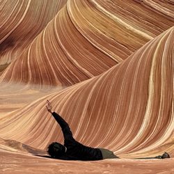
Photo Spots near Glen Canyon Dam Bridge
Places To Take Pictures near Glen Canyon Dam Bridge
Places To Visit near Glen Canyon Dam Bridge
Playgrounds near Glen Canyon Dam Bridge
Psychics near Glen Canyon Dam Bridge
Scenic Drive near Glen Canyon Dam Bridge
Browse Articles
Browse Nearby
BEST of Page, Arizona Restaurants near Glen Canyon Dam Bridge
BEST of Page, Arizona Scenic Drive near Glen Canyon Dam Bridge
BEST of Page, Arizona Coffee near Glen Canyon Dam Bridge
BEST of Page, Arizona Museums near Glen Canyon Dam Bridge
BEST of Page, Arizona Things to Do near Glen Canyon Dam Bridge
BEST of Page, Arizona Breakfast near Glen Canyon Dam Bridge
BEST of Page, Arizona Visitor Centers near Glen Canyon Dam Bridge
BEST of Page, Arizona Hotels near Glen Canyon Dam Bridge
BEST of Page, Arizona Campgrounds near Glen Canyon Dam Bridge
Browse Brands
Related Searches in Page, AZ
Best Fishing Locations and Guides in Page, Arizona
Best Fun Things to Do in Page, Arizona
Best Lookout Points to Visit in Page, Arizona
Best Spots for Star Gazing in Page, Arizona
Book Engaging Historical Tours in Page, Arizona
Discover Charming Historic Homes in Page, Arizona
Discover Fun Things to Do Alone in Page, Arizona
Discover Popular Landmarks in Page, Arizona
Discover Popular Photo Spots in Page, Arizona
Discover the Best Beaches in Page, Arizona
Discover the Best Night Hike Trails in Page, Arizona
Enjoy Arts & Entertainment in Page, Arizona
Enjoy Hiking Adventures in Page, Arizona
Enjoy the Best Night View Spots in Page, Arizona
Enjoy the Best Walking Trails in Page, Arizona
Experience Stunning Sunset Views in Page, Arizona
Explore Beautiful Castles and Landmarks in Page, Arizona
Explore Beautiful Parks and Green Spaces in Page, Arizona
Explore Free Things to Do Around Page, Arizona
Explore Fun Activities to Do in Page, Arizona
Explore Popular Scenic Overlook Points in Page, Arizona
Explore Popular Scenic Views Near Page, Arizona
Explore Popular View Points Around Page, Arizona
Explore Scenic Lakes to Visit in Page, Arizona
Explore Top Things to Do at Night in Page, Arizona
Explore Venues & Event Spaces in Page, Arizona
Find Beautiful Views in Page, Arizona
Find Exciting Tours to Take in Page, Arizona
Find Visitor Centers to Explore in Page, Arizona
Find the Best Bridge Spots in Page, Arizona
Fun Things for Kids in Page, Arizona
Get Your City Pass for Attractions in Page, Arizona
Great Things to See and Do in Page, Arizona
Must-See Tourist Attractions Around Page, Arizona
Perfect Spots to Watch Sunset in Page, Arizona
Popular Outdoor Activities to Try in Page, Arizona
Popular Picnic Spots to Visit in Page, Arizona
Popular Places to Take Pictures in Page, Arizona
Popular Places to Walk Around in Page, Arizona
Popular Things to Do in Page, Arizona
Relax at Natural Hot Springs Near Page, Arizona
Top Entertainment Options in Page, Arizona
Top Hiking Trails to Explore in Page, Arizona
Top Historic Restaurants to Try in Page, Arizona
Top Places to Visit in Page, Arizona for Sightseeing
Top Things to Do With Kids in Page, Arizona
Visit Cultural Centers in Page, Arizona
Visit Popular Museums in Page, Arizona Now