Constellation Trail Photos


You might also consider
More like Constellation Trail
Recommended Reviews - Constellation Trail
Start your review...

Reviews With Photos


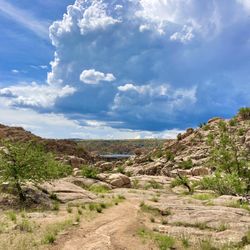
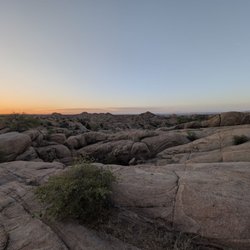
This is one of my favorite trails in prescott and have hiked it many times and many different ways. I would recommend the path below in the pictures. Take north 40 trail to ham and cheese. Then take Holly gully to lost wall trail. Then take rock wall trail to ranch road shortcut to parking lot. This takes you into valleys, ravines, and up to the top of a mountain with an awesome view. The trail is rated easy and is 2.4 miles with an elevation gain of 236 feet if you fallow the path. It takes around an hour to hike but you can mix and match trails as you wish. The trail has a different tarines with walking on dirt and rocky paths and even climbing some rocks. Nothing to difficult it is rated easy. There are benches throughout the trail I call them trail benchmarks. If you are in prescott and have an hour to spare I would check this hike out it gives you a little bit of everything. The trail is dog friendly and is very popular so expect to run into other hikers. The trail is also close to the highway and airport so its not quite. If you are looking for something quite look somewhere else. Looking for a fun hike with awesome views this is the place.

5 months ago


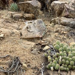
The Constellation trail is a great local hiking area with a series of trails through the north end of the granite dells outcropping. So if you're looking for a short easy one to three hour walk this is a great place to visit. See my older review about the naming of this park dedicated to the Navy Constellation which crashed here. There is ample parking at the trailhead and restrooms. Make sure to bring your water though because it can be hot in the summer. However their are great trees to provide rest areas. It is full of birds and wildlife. read more


 whom was 12 years old in 1959. - Hiking Near Me - Prescott Valley, Arizona")


8 months ago
Great moderate level hike. Trail was well marked with big white dots, signs, amazing views. read more


6 years ago
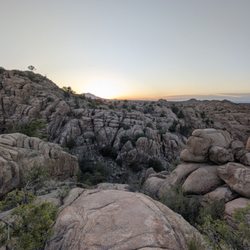
Beautiful area,with lots of different trails to hike. All the trails connect to a large outer circle so you can't get lost. Hikes not to be missed if your in the Prescott area. read more


3 years ago
This is one of my favorite trails in prescott and have hiked it many times and many different ways. I would recommend the path below in the pictures. Take north 40 trail to ham and cheese. Then take Holly gully to lost wall trail. Then take rock wall trail to ranch road shortcut to parking lot. This takes you into valleys, ravines, and up to the top of a mountain with an awesome view. The trail is rated easy and is 2.4 miles with an elevation gain of 236 feet if you fallow the path. It takes around an hour to hike but you can mix and match trails as you wish. The trail has a different tarines with walking on dirt and rocky paths and even climbing some rocks. Nothing to difficult it is rated easy. There are benches throughout the trail I call them trail benchmarks. If you are in prescott and have an hour to spare I would check this hike out it gives you a little bit of everything. The trail is dog friendly and is very popular so expect to run into other hikers. The trail is also close to the highway and airport so its not quite. If you are looking for something quite look somewhere else. Looking for a fun hike with awesome views this is the place. read more


7 years ago
7 years ago
12 years ago
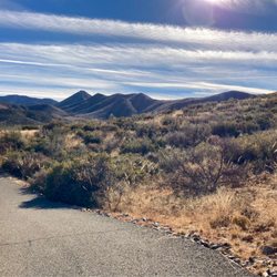
Great trail for hiking and mountain biking! 2.5 mile outer loop with lots of inner loops for variety. We hiked and it was easy to moderate. It looks like a tough trail for mountain biking! Great views from just about everywhere. read more


11 years ago
More info about Constellation Trail
7301-7337 Roundup Dr
Prescott Valley, AZ 86314
Directions
Hours
Outdoor Amenities
Ask the Community - Constellation Trail
Review Highlights - Constellation Trail


Constellation Trail - hiking - Updated July 2026
Best of Prescott Valley
People found Constellation Trail by searching for…
Things to Do in Prescott Valley, Arizona
Parks in Prescott Valley, Arizona
Scenic View in Prescott Valley, Arizona
Places to Take Pictures in Prescott Valley, Arizona
Parks for Kids in Prescott Valley, Arizona
Fun Things to Do With Kids in Prescott Valley, Arizona
Hiking Trails in Prescott Valley, Arizona
Star Gazing in Prescott Valley, Arizona
Off Road Trails in Prescott Valley, Arizona
Scenic Overlook in Prescott Valley, Arizona
Walking Trails in Prescott Valley, Arizona
Mountain Biking in Prescott Valley, Arizona
Hiking With Kids in Prescott Valley, Arizona
Beautiful Views in Prescott Valley, Arizona
Running Trails in Prescott Valley, Arizona
Waterfalls in Prescott Valley, Arizona
Easy Hikes in Prescott Valley, Arizona
Night Hike in Prescott Valley, Arizona
Dog Friendly Trails in Prescott Valley, Arizona
Restaurants With a View in Prescott Valley, Arizona
Off Leash Dog Hiking Trails in Prescott Valley, Arizona
Playground in Prescott Valley, Arizona
Trending Searches in Prescott Valley, AZ
Black Owned Nail Salons near Constellation Trail
Boat Rental near Constellation Trail
Cliff Jumping near Constellation Trail
Creeks near Constellation Trail
Day Trips near Constellation Trail
Dog Friendly Trails near Constellation Trail
Fireworks near Constellation Trail
Kayak Rental near Constellation Trail
Lakes & Ponds near Constellation Trail
Places To Swim near Constellation Trail
Public Pools near Constellation Trail
Public Shower near Constellation Trail
River Swimming near Constellation Trail
Rock Quarry near Constellation Trail
Running Trails near Constellation Trail
Scenic Night View near Constellation Trail
Scenic Overlook near Constellation Trail
Secluded Spots near Constellation Trail
Splash Pad near Constellation Trail
Strawberry Picking near Constellation Trail
Sunrise View near Constellation Trail
Swimming Holes near Constellation Trail
Swimming Lakes near Constellation Trail
Swimming Pools near Constellation Trail
U Pick Farms near Constellation Trail
Watch Sunset near Constellation Trail
Browse Articles
Browse Nearby
BEST of Prescott Valley, Arizona Coffee near Constellation Trail
BEST of Prescott Valley, Arizona Things to Do near Constellation Trail
BEST of Prescott Valley, Arizona Restaurants near Constellation Trail
BEST of Prescott Valley, Arizona Walking Trails near Constellation Trail
BEST of Prescott Valley, Arizona Parks near Constellation Trail
BEST of Prescott Valley, Arizona Breakfast near Constellation Trail
BEST of Prescott Valley, Arizona Hot Springs near Constellation Trail
BEST of Prescott Valley, Arizona Campgrounds near Constellation Trail
BEST of Prescott Valley, Arizona Taxis near Constellation Trail
Browse Brands
Related Searches in Prescott Valley, AZ
Affordable Kayak Rental Services in Prescott Valley, Arizona
Best Fishing Locations and Guides in Prescott Valley, Arizona
Best Places for Horseback Riding in Prescott Valley, Arizona
Best Sledding Spots and Fun in Prescott Valley, Arizona
Check Out Off Road Trails in Prescott Valley, Arizona
Discover Kid Friendly Hiking Trails in Prescott Valley, Arizona
Discover Scenic Mountain Bike Trails Near Prescott Valley, Arizona
Discover a Hiking Trail in Prescott Valley, Arizona
Discover the Best Night Hike Trails in Prescott Valley, Arizona
Dog-Friendly Hikes With Dogs in Prescott Valley, Arizona
Enjoy Camping Adventures Around Prescott Valley, Arizona
Enjoy Exciting Mountain Biking Adventures in Prescott Valley, Arizona
Enjoy Kayaking Adventures in Prescott Valley, Arizona
Enjoy River Tubing Adventures in Prescott Valley, Arizona
Enjoy Tent Camping Spots Around Prescott Valley, Arizona
Enjoy Water Activities and Fun in Prescott Valley, Arizona
Enjoy a Beautiful Waterfall Hike in Prescott Valley, Arizona
Enjoy the Best Family Activities in Prescott Valley, Arizona
Enjoy the Best Tubing Experiences in Prescott Valley, Arizona
Enjoy the Best Walking Trails in Prescott Valley, Arizona
Exciting Cliff Jumping Spots in Prescott Valley, Arizona
Experience Thrilling White Water Rafting in Prescott Valley, Arizona
Explore Beautiful Parks and Green Spaces in Prescott Valley, Arizona
Explore Bike Rentals Throughout Prescott Valley, Arizona
Explore Easy Hikes Perfect for All in Prescott Valley, Arizona
Explore Fun Activities to Do in Prescott Valley, Arizona
Explore Popular Campgrounds Near Prescott Valley, Arizona
Explore Scenic Lakes to Visit in Prescott Valley, Arizona
Explore Secret Spots Worth Visiting in Prescott Valley, Arizona
Explore Top Dog Parks in Prescott Valley, Arizona Near You
Explore the Best Boating Spots in Prescott Valley, Arizona
Explore the Best Swimming Holes Around Prescott Valley, Arizona
Family Friendly Hiking With Kids in Prescott Valley, Arizona
Find Cozy Camping Cabins in Prescott Valley, Arizona
Find Popular Ziplining Spots Around Prescott Valley, Arizona
Find the Best Scenic View Locations in Prescott Valley, Arizona
Hiking Trails With Waterfalls in Prescott Valley, Arizona
Off Leash Dog Hiking Trails in Prescott Valley, Arizona
Perfect Spots to Watch Sunset in Prescott Valley, Arizona
Plan a Scenic Drive Route Near Prescott Valley, Arizona
Popular Fishing Spots to Explore in Prescott Valley, Arizona
Popular Picnic Spots to Visit in Prescott Valley, Arizona
Safe River Swimming Areas in Prescott Valley, Arizona
Safe and Fun Parks for Kids in Prescott Valley, Arizona
Top Climbing Spots and Gyms in Prescott Valley, Arizona
Top Running Trails to Explore in Prescott Valley, Arizona
Top Swimming Lakes to Enjoy in Prescott Valley, Arizona
Top Swimming Spots and Pools in Prescott Valley, Arizona