Cancel

    Open app

    Search

    Chadron State Park

    4.0 (4 reviews)

    Chadron State Park Photos

    Recommended Reviews - Chadron State Park

    Your trust is our priority, so businesses can't pay to alter or remove their reviews. Learn more about reviews.
    Yelp app icon
    Browse more easily on the app
    Review Feed Illustration

    4 years ago

    Helpful 0
    Thanks 0
    Love this 0
    Oh no 0

    9 years ago

    Helpful 0
    Thanks 0
    Love this 0
    Oh no 0
    Photo of Roy S.
    3
    548
    0

    13 years ago

    Helpful 0
    Thanks 0
    Love this 0
    Oh no 0

    9 years ago

    Helpful 0
    Thanks 0
    Love this 0
    Oh no 0

    Verify this business for free

    Get access to customer & competitor insights.

    Verify this business

    Agate Fossil Beds National Monument - 07.07.24 Hitchcock Theater at the  Agate Fossil Beds National Monument

    Agate Fossil Beds National Monument

    4.6(10 reviews)
    42.0 mi

    Fossils in the hills of Nebraska [Harrison NE]…read more This national monument is located in Western Nebraska. Let me tell you now... it is out in the middle of nowhere! One lone building... the Visitor Center! You have to drive to the open prairie where the fossils can be found on quarries where the digs were conducted. Unfortunately, we were on a tight schedule and was not able to do the hike. Inside the Visitor Center is full of interesting exhibits Including a life-size display of ancient mammals (giant creature that looks like a pig). There are no dinosaur fossils here. We also saw some cool collection of Northern Plains Indian artifacts given as gifts to James Cook by Lakota Chief Red Cloud. The short film was educational. Tip: Make sure to gas up your car and bring snacks or pack a lunch before heading out to the monument. The closest gas station is over 30 miles out on Highway 29 heading either north or south. There are no vending machines at the Visitor Center but they have free WiFi available ¯\_(ツ)_/¯ Review #3503

    Visited Agate Fossil Beds National Monument on Sunday, September 17…read more In addition to fossils and Devil's Corkscrews we saw a great collection of Lakota Sioux memorabilia from the James Cook collection. Shout out to Amelia for spilling the tea on the Cook family, and showing us the prized cow pie from the Cook collection - not on open display. The fossil beds themselves were amazing but Amelia was fantastic, she made the visit.

    Photos
    Agate Fossil Beds National Monument - Kid art

    Kid art

    Agate Fossil Beds National Monument - 07.07.24 Agate Fossil Beds National Monument

    07.07.24 Agate Fossil Beds National Monument

    Agate Fossil Beds National Monument - 07.07.24 Agate Fossil Beds National Monument [Harrison NE]

    See all

    07.07.24 Agate Fossil Beds National Monument [Harrison NE]

    Badlands National Park - Picnic area near Deer Haven

    Badlands National Park

    4.8(329 reviews)
    75.6 mi

    Visiting the White River Valley Overlook inside Badlands National Park was one of the highlights of…read moreour trip. This is one of those places that completely catches you off guard in the best way. You pull over expecting a quick viewpoint, and then suddenly you're looking out over this massive, open valley that just seems to go on forever. The contrast between the rugged Badlands formations and the wide, rolling landscape below is incredible. It honestly feels like two completely different environments meeting in one place. The colors, the textures, and the sheer scale of it all make it feel almost unreal when you're standing there. What makes this stop even better is how easy it is to access. There's no long hike required--just park, walk a short distance, and you're right there taking in one of the best views in the park. It's perfect for all ages and a great place to pause and really appreciate the scenery. If you're visiting the Badlands, this overlook is absolutely worth the stop. It's peaceful, stunning, and unforgettable. Check out our videos on our socials @reessroots

    "You spend your life waiting For a moment that just don't…read morecome Well don't waste your time waiting Badlands, you gotta live it everyday" (Bruce Springsteen) The last National Park visit of our trip may have been my favorite. The sheer sight of these massive rock formations, cliffs, buttes, pinnacles and spires truly made me feel as if I was a space traveler that had crash landed on the ancient world of a distant planet. Words cannot adequately describe the majesty of what I saw. Badlands also has the largest protected mixed grass prairie in America and is home to bison, bighorn sheep, prairie dogs, and black-footed ferrets. The park is also famous for its abundance of fossils. I read that ancient horses and rhinos once roamed here. We were able to walk out into the rock formations and overlooked the vast multi-colored stone canyons and valleys, marvel at the soaring cliffs and gorges, and just revel in this fantastic natural beauty. Talk about a religious experience, it was simply gorgeous and breathtaking. Badlands Facts Badlands National Park is our 39th National Park and was established on November 10, 1978. Badlands is a mid-sized park with 244,000 acres Badlands draws around 1 million visitors per year.

    Photos
    Badlands National Park
    Badlands National Park
    Badlands National Park

    See all

    Custer State Park

    Custer State Park

    4.7(280 reviews)
    78.9 mi

    I love the park. My favorite time to drive through the park is during late spring and early summer…read morewhen all the animals are having their babies. It is the cutest thing ever. The scenery is so varied and breathtaking. I could go through the park every day

    We started off our day at Custer State Park. We began by going into the visitor center, which is an…read moreabsolute MUST DO. Why? Because when you walk in there is a large scale model of the park and they mark it to show the last reported sighting of bison. The volunteers then showed us how to find that area, and they also showed us another visitor center along the way where they recommended we stop to get further updated information. The bison were located at the southern end of the park, so the beginning of our drive was just through beautiful landscape, without much wildlife at that point. We stopped as instructed at the next visitor center, and got an updated status of the bison, as well as directions on how to find them, as you needed to go off on one of the side roads. We headed off, and then as we rounded the bend on the road there they were! Hundreds of bison as far as you could see. It was absolutely amazing. You can easily pull to the side of the road and stop, and you can roll down your windows and just observe - it was incredible. Several times we were stopped along the way as they crossed the road in front of us. It was absolutely one of the highlights of our trip to South Dakota. After we finished driving through the herd, we continued our journey and ended up at the Blue Bell Lodge for lunch, which we highly recommend. From there, we drove the Needles Highway, a big portion of which in our case was done in the rain. But despite the rain, there was still lots to see, even though a lot of it for us was from inside the car, where we periodically rolled down the windows to take pictures. I would say our day at Custer State Park was absolutely the best experience we had during the entire stay in South Dakota, so I would highly, highly recommend it!

    Photos
    Custer State Park
    Custer State Park - Bison Center

    Bison Center

    Custer State Park - Sylvan Lake Kayaking

    See all

    Sylvan Lake Kayaking

    Scotts Bluff National Monument - 07.07.24

    Scotts Bluff National Monument

    4.5(51 reviews)
    69.1 mi

    Call Your Bluff…read more Protected National Monument site that's over 3k-acres and is situated west of Gering, Nebraska. We visited here almost eight years ago on our epic road trip across the US, and I can't believe I forgot to review this place. The Good: *The bluff is an important landmark on the Oregon Trail and there's an Oregon Trail Museum at the base of the bluff. *There's a windy 1.6-mile drive up the Summit Rd to get to the top of Scotts Bluff. There were quite a few cars (the park draws in 100k visitors a year) in front of us, if I remember correctly. But I don't think it took that long to get to the top, because even if it did there some superb views along the way up. *Leashed pets are OK on trails *Free! The Meh: *Only four miles of hikable trails The Ugly: *I wish we had more time to explore and hike the trails, but we had a schedule to keep. Next time, Gadget! Conclusion: Great park that's worth a 1hr detour if you're headed along on this stretch of 80.

    WOW - if you have a change to visit, GO! Such beauty!…read more - - - May, 2025 Visit - - - My wonderful wife and I were able to enjoy a getaway weekend, with a visit to Devils Tower, WY; we flew through Denver and drove to NE Wyoming. We stayed in Torrington, WY; as we woke up we looked at the map and realized how close we were to Scott's Bluff National Monument, so we decided to make a visit, and we're glad we did. - - - One of the signs at the Park / Monument shares that the Indians / the Native Americans called Scotts Bluff "Me-a-pa-te", or "hill that is hard to go around." Scotts Bluff is along the Oregon Trail, which runs through the Monument / Park. Given how flat the Nebraska plains are, and that this is 800 feet tall, you can see Scotts Bluff from about 100 miles away, and giben that the wagon trains made ~ 10-12 miles per day (or less), you could surely see it for 7-10 days before and after passing it. So... "hill the is hard to go around" is appropriate and accurate! - - - The Visitor's Center is nice and the NPS staff friendly and helpful. - - - There is a trail that you can walk up to wonderful views from the Bluff; along the way you may (or may not) be surprised to see some plants that could also be seen further west, in Joshua Tree and other National Parks - agave and yucca. The Monument is near a highway, so you may occasionally hear a little road noise, but it is infrequent and you're able to readily hear birds and bugs as you enjoy the hike. As we drove in, along Highway 26 we could see the Monument off in the distance. We then turned down a road to capture some photos; a few minutes later a farmer drove by and slowed and offered to show us the way to the Monument by driving us in "the back way" where we drove the Oregon Trail into the parking lot - wonderful! So, driving-wise, we recommend coming in via Hw 92... from Torrington... Hw 26 E to Mitchell to Hw 29 S to Hw 92 E to the "Old Oregon Trail Road" - - - The Monument towers so tall... Beautiful! And tall. There is an audio tour you can listen to your phone... the sings have the phone number to call and listen... this is a wonderful listen - thank you, National Park Service (NPS) for creating / providing this audio tour. - - - We followed the trail up to the top, to where it passes through the hand-made tunnel to the other side. We rose 400 feet in elevation and were blessed with a nice breeze and an amazing view. - - - When the US Mint made the state quarters, Nebraska selected Chimney Rock for their quarter; Chimney Rock is 20-23 miles from Scotts Bluff, AND is visible from the trail... so nice! - - - Thank you, National Park Service for maintaining Scotts Bluff National Monument, for us and for future generations! If you have a chance to visit, GO! ----- ----- -----

    Photos
    Scotts Bluff National Monument
    Scotts Bluff National Monument
    Scotts Bluff National Monument - 07.07.24

    See all

    07.07.24

    Hudson-Meng Bison Bonebed - Gate between sections of pasture.

    Hudson-Meng Bison Bonebed

    5.0(1 review)
    33.5 mi

    If you're on a road trip and adventurous enough to seek out Carhenge, why not get slightly more…read moreadventurous and seek out the VERY remote Hudson-Meng Bison Bonebed in the Ogalalla National Grasslands, the site where paleo-humans left the bones of many hundreds of ancient bison (without the skulls), over many hundreds of years, piled and scattered over a small area. At the end of 15-miles of gravel road, there is a small parking lot, restrooms with plumbing, a small pond teeming with loud frogs and surrounded by lush greenery and shade-trees, and an air-conditioned archealogical dig/gift shop/visitors center, about the size of a large barn. A small staff will greet you, show you an informational video about the history of the bonebed and give you a tour of the archealogical dig and show you the bones. It may not be as large and perhaps not as interesting as the fossilized rhinoceroses at the Ashfall in northeastern Nebraska several hours east from here, nor does it have the (ahem) mammoth proportions of the VERY interesting mammoth site in Hot Springs, South Dakota a short drive to the north (both of which are highly recommended), but it does offer a trailhead into the Toadstool Geological Formation located in adjacent grasslands. The Bison Trail runs out from about the entrance to the visitors center, across federal grazing lands, down into several "badlands"-style gullies and to the Toadstool campground - 3 miles away, for a six-mile out and back hike. At least one other trail intersects this trail about a mile out with signage noting that Toadstool is three miles down it also, so you can make the hike longer, or shorter, or into a loop as desired. Enjoy the strategically placed bison sculptures that give a sense of what ancient humans might have seen along this same trail. There are also numerous cattle trails cutting this way and that through the grasslands, but the intentionally placed human trail is marked by wooden sign-posts sticking up out of the prairie grass about 50-100 yards apart to show you the way. The ranger also told us that we were welcome to just wander about wherever we wanted, sign-posts-be-damned. But you may have to contend with a barbed-wire fence or two or three - there are, however, gates or slots through the fence that human hikers can fit through on the regular trail. 
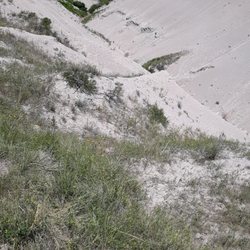
From the visitors center, the trail goes down into and up out of a small shaded gully, then out to another large gully that looks more like the badlands. Down into and up out of the second gully, then across more grasslands to a third gully (about 1.3 miles from the visitors center), where the trail descends down into the gully from its highest point, and then down through the bottom of the gully for some distance. When we went, the trail at the bottom of the gully was extremely muddy - so we didn't make it all of the way to Toadstool. We turned around at the first turn at the bottom of the gully where it got muddy. We walked along the gully at its top edge for a ways, however, to see what we were missing from the top. In this first mile and a half we did not see any so-called toadstool formations, but it is a uniquely and starkly beautiful landscape, with the sparsely wooded hills behind you above the visitors center, with the slope of grasslands below you, the badlands features spreading out through significant portions of the vista below you. And if you are lucky (?) you might even run into a herd of beef cattle, and might even accidentally cut a small group of them off from the main herd; and then have to hide below a rise so as not to spook the stragglers so that they can find their herd. Not saying it happened that way, but it might happen to you too.

    Photos
    Hudson-Meng Bison Bonebed
    Hudson-Meng Bison Bonebed - The Bison Trail to the Toadstool campground runs along the bottom of this ravine.

    The Bison Trail to the Toadstool campground runs along the bottom of this ravine.

    Hudson-Meng Bison Bonebed - A short tortuous path in one of the large gullies along the trail.

    See all

    A short tortuous path in one of the large gullies along the trail.

    Chadron State Park - parks - Updated May 2026

    Loading...
    Loading...
    Loading...