Byrne-Milliron Forest Photos


You might also consider
More like Byrne-Milliron Forest
Recommended Reviews - Byrne-Milliron Forest
Start your review...

Reviews With Photos

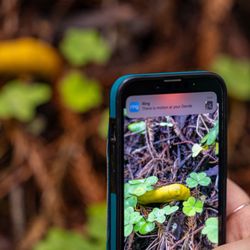
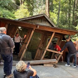
So happy that I went yesterday and was still possible to visit the forest! From today to August 10th is going to be undergoing serious road repairs (damaged after the heavy storms last winter and spring). As someone pointed out, this is a forest of not so easy access, so be prepared to go with a car that can handle unexpected encounters, since dealing with one direction only roads. That was part of the adventure but was really scary, especially when passing by the damaged areas. Other than that, this is a magic forest indeed! I found about it thanks to be a hoarder of all those free magazines about 'things to do' that you get at coffee shops, etc. In this case I found about the Byrne-Milliron forest existence thanks to a 'things to do around Santa Cruz' mag, and not from the VIA mag that AAA send to its members (I wonder how come I passed this jewel, as I devour that magazine as well:). If you are celebrating the spirit of 'Summer of Love '67' like i am doing...this is your hippie flower power forest! You can tell it was well taken care for 25 years by someone I presume was an awesome dude very loved and of course remembered, as he left the whole forest filled with trinkets, funky items, cool stuff, notebooks to write or draw in and little pieces of joy. The views are great and remember to bring tons of water as the ways up are too steep. I brought my poles, they make a difference for sure, especially on the way down will help your knees tremendously. In case you forget those, there is one of those milk cans at the entrance with some wood ones. I am amazed about the generosity of visitors or even this now deceased (but with his spirit alive in the forest) caretaker: you can open one of these old mailboxes and get the binoculars to observe the birds and landscape. It was a pleasure. Next time will visit the white redwood...got too tired this time.
Just opened to the public last summer (2020), thanks to tik tik, I now have a new place to go hiking. Takes about 45-50 mins from San Jose to get here. It's in the middle of no where, so be prepared to get lost and intuned with nature. Directions via Apple map is very accurate. There are no fees to park and pretty reliable signal once at the preserve. Dogs are allowed on and off leash. Parking lot fits about 20 cars. I came with my bf and his cousin for a New Years hike to start off the year. The last park getting to the place is a left turn into what seems like private property. It is. Keep going. It then turns into what looks like a one way, but it's for two cars. Two cars don't fit, so drive slow and be patient with cars coming in the opposite direction. This part does get scary. I went on New Years and it was jam packed with people. Even at 1pm!!!! Again, park lot fits about 20 cars. We got lucky when arriving and waited for parking. There's a porter potty for bathroom needs before starting your hike. There is a check in you need to do either by paper or the internet. It's quick and easy. Onto the trail you go. Aj's point of view has a newly built deck, which is why I came. Probably going to go viral soon and many people will flock to see the view. I wish my future backyard looked like that!!!! Amazing view. The ocean reflecting in the back against the sun just is indescribable. If you take Byrne to rattlesnake, but be aware, ITS ALL UPHILL. 1 mile of straight brutal uphill. My calves were tight the whole way up and I kept cursing in my head. Yes, we were all hung over from the night before so we were all sweating up a storm and sweating our hang over off. It was good but intense. Even without being hung over, it is quite a steep trail. The elevation gain is quick. After what seemed like forever, we made it to aj's point of view. Hung out. Took a few pictures and headed down. We wanted to go to the beach so we didn't hit the other trails. Going down was easy. 5 mins and we were down. Running and skipping all the way down. Can't wait to come back to explore the other trails!

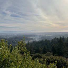
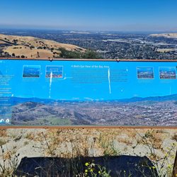
We finally went to Byrne-Milliron Forest which is a part of Land Trust of Santa Cruz County. I saw it mentioned in the VIA Magazine and friend went there before me. From Hayward where I meet my friends it was 1hr30min drive on Veterans Day 11/11/15. Using GPS we didn't get lost. FREE parking, there is 1 porta potty in the parking lot. We Went up Byrne Trail on the Left to Milliron Trail where we saw the "Great White" Redwood Tree. We couldn't do the Great White Loop due to Winter Trail Conditions. There is a steep section on the Milliron Trail but they put a rope next to it so we used it go down then up. We backtracked to Milliron Trail - Bryne Trail - down a bit to Ridge Top Rd, then we continued to AJs Point of View where you get a view of Pajaro Valley and Monterey Bay, plus the Pacific Ocean. Back to Ridge Top Rd - Porcupine Hollow - missed out on the wooden artwork for Eagle On Stump which should be near the sign. We went to Cathedral Rest Spot where the bench has a cross on it. Did the Leonard Bartle Trail, near it on the Left is Three Bears Artwork, back down to Byrne Trail. I'd go back if I can get someone to take me.


We found out about Byrne-Milliron Forest through the VIA magazine. We went on Black Friday, November 27, 2015,and also #OptOutside. It was peaceful and quiet as we were one of the few guests in the area. The trinkets along the trails were fun. Love the views of the Santa Cruz mountains. We loved the idea of guests writing in journals at various viewpoints. In the beginning of the trail, pick up a copy of the trail map so you won't get lost. We went through the Byrne Trail, Rattlesnake Trail, and saw spots like AJ's post, Eagle on Stump, Bathtub, etc. Follow the directions from the Land Trust of Santa Cruz website. You will drive uphill until you reach a parking lot. http://www.landtrustsantacruz.org/category/protected-lands/byrne-milliron-forest/ One portable toilet is at the parking lot. Don't forget to bring water and snacks for the hike.

2 months ago
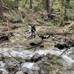
I had a very good experience at the park. Leashed dogs are allowed on trails which can be rare in so many parks in this area. So it was great to be able to have my dogs along. However, be very careful because there are lots and lots of poison oak. So make sure that you stay on the trail with your dog and away from those bushes. It was also a great workout, because the trails are all going uphill, so they are great for giving your heart going. Free parking and there is a bathroom. Remember to bring your dog poo poo bags until dispose of them properly. The road to get to the park right after you turn from the main highway is very narrow at some point and you have to drive very slowly. Just be slow and careful and you will be fine, it was a bit intimidating at first, but it is a very short amount of time in which you drive from the very narrow section before you get to the park. Also remember to make your reservation on their website ahead of time. Although the parking is free, you are required to register. read more


3 years ago
Great hike, I was able to hike the entire area in about 2h30min. There's lots of different trails that you can take based on your hiking experience. Very peaceful and not crowded (I went on a Saturday morning). Plenty of parking spaces. read more


5 years ago
Giving this place 4 stars because it was so incredibly hard to find, and the drive in was ridiculously hard! This place and hike was recommend to us by a friend who lives in the area because it's a great choice for those who love hiking with their dogs! You have to turn off a small 2 lane road with a sign marked 809 "roses of yesterday" and turn up a steep, very thin driveway and follow it for a few miles on a steep single lane road with the most speed bumps I've ever seen. It's a bit confusing to get in there, and almost possible to pass cars. We were happy we visited on a weekday afternoon because there's no way I'd want to visit on a weekend. we finally reached the gravel parking lot off to the right and there was plenty of parking and a porta potty. I made sure to screenshot the map to my phone, but we still found the trails to be a bit confusing to follow. We chose to hike up to AJ's point of view in the middle and I would not recommend that hike or rattlesnake trail to those who cannot do strenuous hikes as it's almost all uphill and I was dying the entire time. Our dog came back with a few ticks and this place was really hard to get to - because of this we won't be back. It was nice to experience once. read more


So happy that I went yesterday and was still possible to visit the forest! From today to August 10th is going to be undergoing serious road repairs (damaged after the heavy storms last winter and spring). As someone pointed out, this is a forest of not so easy access, so be prepared to go with a car that can handle unexpected encounters, since dealing with one direction only roads. That was part of the adventure but was really scary, especially when passing by the damaged areas. Other than that, this is a magic forest indeed! I found about it thanks to be a hoarder of all those free magazines about 'things to do' that you get at coffee shops, etc. In this case I found about the Byrne-Milliron forest existence thanks to a 'things to do around Santa Cruz' mag, and not from the VIA mag that AAA send to its members (I wonder how come I passed this jewel, as I devour that magazine as well:). If you are celebrating the spirit of 'Summer of Love '67' like i am doing...this is your hippie flower power forest! You can tell it was well taken care for 25 years by someone I presume was an awesome dude very loved and of course remembered, as he left the whole forest filled with trinkets, funky items, cool stuff, notebooks to write or draw in and little pieces of joy. The views are great and remember to bring tons of water as the ways up are too steep. I brought my poles, they make a difference for sure, especially on the way down will help your knees tremendously. In case you forget those, there is one of those milk cans at the entrance with some wood ones. I am amazed about the generosity of visitors or even this now deceased (but with his spirit alive in the forest) caretaker: you can open one of these old mailboxes and get the binoculars to observe the birds and landscape. It was a pleasure. Next time will visit the white redwood...got too tired this time. read more


Just opened to the public last summer (2020), thanks to tik tik, I now have a new place to go hiking. Takes about 45-50 mins from San Jose to get here. It's in the middle of no where, so be prepared to get lost and intuned with nature. Directions via Apple map is very accurate. There are no fees to park and pretty reliable signal once at the preserve. Dogs are allowed on and off leash. Parking lot fits about 20 cars. I came with my bf and his cousin for a New Years hike to start off the year. The last park getting to the place is a left turn into what seems like private property. It is. Keep going. It then turns into what looks like a one way, but it's for two cars. Two cars don't fit, so drive slow and be patient with cars coming in the opposite direction. This part does get scary. I went on New Years and it was jam packed with people. Even at 1pm!!!! Again, park lot fits about 20 cars. We got lucky when arriving and waited for parking. There's a porter potty for bathroom needs before starting your hike. There is a check in you need to do either by paper or the internet. It's quick and easy. Onto the trail you go. Aj's point of view has a newly built deck, which is why I came. Probably going to go viral soon and many people will flock to see the view. I wish my future backyard looked like that!!!! Amazing view. The ocean reflecting in the back against the sun just is indescribable. If you take Byrne to rattlesnake, but be aware, ITS ALL UPHILL. 1 mile of straight brutal uphill. My calves were tight the whole way up and I kept cursing in my head. Yes, we were all hung over from the night before so we were all sweating up a storm and sweating our hang over off. It was good but intense. Even without being hung over, it is quite a steep trail. The elevation gain is quick. After what seemed like forever, we made it to aj's point of view. Hung out. Took a few pictures and headed down. We wanted to go to the beach so we didn't hit the other trails. Going down was easy. 5 mins and we were down. Running and skipping all the way down. Can't wait to come back to explore the other trails! read more


5 years ago
We finally went to Byrne-Milliron Forest which is a part of Land Trust of Santa Cruz County. I saw it mentioned in the VIA Magazine and friend went there before me. From Hayward where I meet my friends it was 1hr30min drive on Veterans Day 11/11/15. Using GPS we didn't get lost. FREE parking, there is 1 porta potty in the parking lot. We Went up Byrne Trail on the Left to Milliron Trail where we saw the "Great White" Redwood Tree. We couldn't do the Great White Loop due to Winter Trail Conditions. There is a steep section on the Milliron Trail but they put a rope next to it so we used it go down then up. We backtracked to Milliron Trail - Bryne Trail - down a bit to Ridge Top Rd, then we continued to AJs Point of View where you get a view of Pajaro Valley and Monterey Bay, plus the Pacific Ocean. Back to Ridge Top Rd - Porcupine Hollow - missed out on the wooden artwork for Eagle On Stump which should be near the sign. We went to Cathedral Rest Spot where the bench has a cross on it. Did the Leonard Bartle Trail, near it on the Left is Three Bears Artwork, back down to Byrne Trail. I'd go back if I can get someone to take me. read more


6 years ago
Just got off phone with Land Trust... BM is NOT closed forever, just during the Winter months due to rain damage, etc. They are hopeful it will re-open in April 2020. Look forward to getting out there again and enjoying the great trails and scenery! read more

We found out about Byrne-Milliron Forest through the VIA magazine. We went on Black Friday, November 27, 2015,and also #OptOutside. It was peaceful and quiet as we were one of the few guests in the area. The trinkets along the trails were fun. Love the views of the Santa Cruz mountains. We loved the idea of guests writing in journals at various viewpoints. In the beginning of the trail, pick up a copy of the trail map so you won't get lost. We went through the Byrne Trail, Rattlesnake Trail, and saw spots like AJ's post, Eagle on Stump, Bathtub, etc. Follow the directions from the Land Trust of Santa Cruz website. You will drive uphill until you reach a parking lot. http://www.landtrustsantacruz.org/category/protected-lands/byrne-milliron-forest/ One portable toilet is at the parking lot. Don't forget to bring water and snacks for the hike. read more


6 years ago
9 years ago
7 years ago
10 years ago
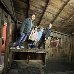
What a unique hike. When all the trails through the redwoods start looking the same, the little trail system here really stands out. Some great views, well kept trails, kitschy things waiting to be discovered. Wish you had a hiking stick? There is a milk can of them. Ran out of water? There are large plastic bottles full at the vista points. Want to picnic? There are picnic tables. Is your dog thirsty? There are water bowls at most trail signs. Curious about others who have enjoyed the trail? Check out the journals they've sketched in or the poems they've written or the totems they've left behind. Definitely an experience! read more


7 years ago
10 years ago
9 years ago
More info about Byrne-Milliron Forest
809 Browns Valley Rd
Corralitos, CA 95076
Directions
(831) 429-6116
Call Now
Visit Website
http://www.landtrustsantacruz.org
Hours
Indoor Amenities
Outdoor Amenities
Other Amenities
From the Business
Ask the Community - Byrne-Milliron Forest
Review Highlights - Byrne-Milliron Forest
You might also consider


Byrne-Milliron Forest - hiking - Updated July 2026
Best of Corralitos
People found Byrne-Milliron Forest by searching for…
Things to Do in Corralitos, California
Parks in Corralitos, California
Hiking Trails in Corralitos, California
Beaches in Corralitos, California
Beautiful Views in Corralitos, California
Dog Friendly Hiking Trails in Corralitos, California
Places to Take Pictures in Corralitos, California
Walking Trails in Corralitos, California
Redwood Trees in Corralitos, California
Picnic Areas in Corralitos, California
Scenic View in Corralitos, California
Dog Friendly Beaches in Corralitos, California
Running Trails in Corralitos, California
Scenic Overlook in Corralitos, California
Swimming Lakes in Corralitos, California
Off Road Trails in Corralitos, California
Dog Friendly Things to Do in Corralitos, California
Redwood Forest in Corralitos, California
Secret Spots in Corralitos, California
Parks for Kids in Corralitos, California
Free Parking in Corralitos, California
Secluded Spots in Corralitos, California
Trending Searches in Corralitos, CA
4th Of July Fireworks near Byrne-Milliron Forest
Black Owned Nail Salons near Byrne-Milliron Forest
Boat Rental near Byrne-Milliron Forest
Cliff Jumping near Byrne-Milliron Forest
Day Trips near Byrne-Milliron Forest
Dog Friendly Trails near Byrne-Milliron Forest
Fireworks near Byrne-Milliron Forest
Jet Ski Rental near Byrne-Milliron Forest
Kayak Rental near Byrne-Milliron Forest
Lakes & Ponds near Byrne-Milliron Forest
Off Road Trails near Byrne-Milliron Forest
Outdoor Activities near Byrne-Milliron Forest
Places To Walk Around near Byrne-Milliron Forest
Public Pools near Byrne-Milliron Forest
Public Shower near Byrne-Milliron Forest
River Swimming near Byrne-Milliron Forest
Rock Quarry near Byrne-Milliron Forest
Running Trails near Byrne-Milliron Forest
Scenic Night View near Byrne-Milliron Forest
Secluded Spots near Byrne-Milliron Forest
Soccer Store near Byrne-Milliron Forest
Splash Pad near Byrne-Milliron Forest
Strawberry Picking near Byrne-Milliron Forest
Sunrise View near Byrne-Milliron Forest
Swimming Holes near Byrne-Milliron Forest
Swimming Lakes near Byrne-Milliron Forest
Watch Sunset near Byrne-Milliron Forest
Browse Articles
Browse Nearby
Browse Brands
Related Searches in Corralitos, CA
Affordable Kayak Rental Services in Corralitos, California
Best Fishing Locations and Guides in Corralitos, California
Best Nature Trails for Hiking in Corralitos, California
Best Places for Horseback Riding in Corralitos, California
Check Out Off Road Trails in Corralitos, California
Discover Dog Friendly Trails to Explore in Corralitos, California
Discover Kid Friendly Hiking Trails in Corralitos, California
Discover Scenic Waterfall Spots in Corralitos, California
Discover a Hiking Trail in Corralitos, California
Discover the Best Night Hike Trails in Corralitos, California
Discover the Best Running Track in Corralitos, California
Dog-Friendly Hikes With Dogs in Corralitos, California
Enjoy Camping Adventures Around Corralitos, California
Enjoy Exciting Mountain Biking Adventures in Corralitos, California
Enjoy Kayaking Adventures in Corralitos, California
Enjoy Tent Camping Spots Around Corralitos, California
Enjoy a Beautiful Waterfall Hike in Corralitos, California
Enjoy the Best Picnic Spots and Ideas in Corralitos, California
Enjoy the Best Walking Path in Corralitos, California
Enjoy the Best Walking Trails in Corralitos, California
Exciting Cliff Jumping Spots in Corralitos, California
Experience Thrilling White Water Rafting in Corralitos, California
Explore Beautiful Parks and Green Spaces in Corralitos, California
Explore Easy Hikes Perfect for All in Corralitos, California
Explore Fun Activities to Do in Corralitos, California
Explore Popular Campgrounds Near Corralitos, California
Explore Popular View Points Around Corralitos, California
Explore Top Dog Parks in Corralitos, California Near You
Explore the Best Beach Spots in Corralitos, California
Explore the Best Boating Spots in Corralitos, California
Explore the Best Trail Options in Corralitos, California
Family Friendly Hiking With Kids in Corralitos, California
Find Popular Ziplining Spots Around Corralitos, California
Find the Best Parks for Picnics in Corralitos, California
Great Places to Walk in Corralitos, California
Hike the Popular Waterfall Trail in Corralitos, California
Hiking Trails With Waterfalls in Corralitos, California
Off Leash Dog Hiking Trails in Corralitos, California
Plan a Scenic Drive Route Near Corralitos, California
Popular Outdoor Activities to Try in Corralitos, California
Popular Picnic Spots to Visit in Corralitos, California
Safe River Swimming Areas in Corralitos, California
Safe and Fun Parks for Kids in Corralitos, California
Top Climbing Spots and Gyms in Corralitos, California
Top Running Trails to Explore in Corralitos, California
Top Swimming Lakes to Enjoy in Corralitos, California
Top Swimming Spots and Pools in Corralitos, California
Top Things to Do With Kids in Corralitos, California
Walk Dog Friendly Hiking Trails in Corralitos, California
Walk the Best Paved Walking Trails in Corralitos, California
People who viewed Byrne-Milliron Forest also viewed
Pogonip
44 reviews
Forest of Nisene Marks State Park
230 reviews
Watsonville Wetlands
1 review
Wilder Ranch State Park
303 reviews
Polo Grounds Bicycle Park
2 reviews
Fremont Peak State Park
41 reviews
Moore Creek Preserve
4 reviews
Seacliff Village County Park
3 reviews
Fall Creek - Henry Cowell Redwoods State Park
97 reviews
Garfield Park
3 reviews