Boynton Canyon Trail Photos


You might also consider
More like Boynton Canyon Trail
Recommended Reviews - Boynton Canyon Trail
Start your review...

Reviews With Photos
Came around 10am and we were super lucky to get a parking spot in the lot. It's $5 and you can pay through the pay machine. Theres one restroom stall located at the lot. This was an absolutely gorgeous trail. I felt immersed into the red rock mountains. The trail has some shaded areas which is nice. A lot of the terrain is rocky so it's best to have good grip shoes. We took the detour route to get to the subway lookout. That detour was more inclined and rocky. To get to the subway lookout, you have to climb a crazy incline. There were two ways to go. One way you have more grip with big rock pieces, but you'd have to walk on a narrow edge around the mountain to get to the spot. The other way is climbing up a slipper inclined rock. It didn't have too much grip or grooves and I almost slid down a few times. The view is definitely worth it. It's an awesome spot and so cool how the rocks formed that way. There was a good amount of people, but the line wasn't long to get a picture. The way down was rough since it was slippery. I was battling with the fear of heights, but I made it! Absolutely stunning.

Beautiful start to a wonderful day of hiking with my best friend and partner. We started this one because it's known to be the heart of all the Vortex energy Hikes. We did knock out all the vortex hikes. This is a relatively easy hike, they have a bathroom and also parking. Again spots fill fast so grab what you see first. Make sure you get your hiking pass before hand. The views from the top are amazing and they had markers along the way so you did not get lost. In all try this hike out it's pretty amazing

I got here around 7:15am and the main parking lot was already full. There was still plenty of parking on the side of the road though. I did the shorter Boynton Vista Trail that led to a vortex. You are also rewarded with a nice view. It was an easy hike with a little climbing of rock steps in the end. If I was to return to Sedona, I will have to attempt the Subway Cave next time!

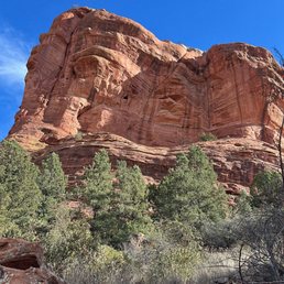
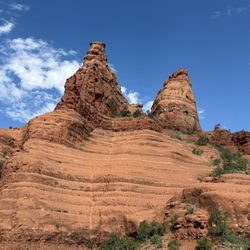
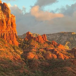
Boynton Canyon Trail is one of the true jewels of the greater Sedona region. Not only does it take you to one of the essential vortexs of the area, but throughout its entire span you see beautiful, topography, great rock formations, plant, and wild life. It's truly an inspiring trail to walk upon. Located just outside of central Sedona, this trail is fairly easy to get to. It does have a main parking lot set up for you to park your car. But, it's important to note that this parking lot fills up quickly. In this case, your best bet is to park down the side of the road, just a bit away from the trailhead, There, you can oftentimes find parking. Keep in mind, however, this is a popular trail, so sometimes you may have to park as far as a mile away to even get to it on weekends and during the summer holidays. This is not a hard trail to hike upon, for those of you who don't like intense strenuous activities. Yes, there is some up and down, and it does transverse fora long range. But, if you take your time, you should have no trouble, enjoying the beauty that you will take in while walking on this trail. Overall, this is one of my favorite hiking spots in Sedona. Rain or shine, it is always a beautiful place to take in the scenery, breathe some very clean air, get your exercise on, and take in all of the great and vital energy that Sedona has to offer.

Boyton Canyon was one of the more unique Arizona Trails we experienced, as it offered a variety of different terrains to explore- Starting off with an easy flat path dessert walk, leading to an inclined path with gorgeous backdrop views of rock formations & mountain peaks- I kept wondering if the path was going to lead up a mountain with some bouldering, but it merely wove around- it transcended through villa homes & resorts, giving less private nature beauty, but still scenic Eventually, the signage died out & we lost our directional awareness, but this worked to our advantage as we stumbled upon other hikers, we followed them to what we thought was Boyton Canyon continued, but was actually the Subway Cave- The cave was an amazing side trip. The scramble up the 'subway' was quite a thrilling challenge- then tiptoeing around the rock edges to the historic rock formation cave walls, offered the most tranquil views of natural beauty- After exploring the cave & nearby rock edges, we finished along Boyton Canyon- which changed into an eerie haunted forest vibe with deep wilderness, thick trees- the temperature dropped about 10degrees entering this portion and the air thinned out- But the end of Boyton was anticlimactic-nothing, I think compared to some photos we saw online they shorted the end of the trail recently for reforestation conservation Overall a great hike- highly recommend

Plan according if you plan to do the full hike to the end of the canyon or just to Subway. Figure total 7+ miles to do both the canyon end and the cave. Subway is a right hand turn off with NO sign just a big Juniper Tree. You should see a well worn track to the right on your way out. A god healthy climb to the subway cave. If you want the easy way up avoid the chute straight up and take the more steep trail to the left.


I hiked Boynton canyon trail to the subway cave and the views were incredible! There's no sign for turn to the cave but there's a large rock arrow. The chute to get up the cave is a bit spooky but there's also a trail to the left you can take instead. The parking lot is small and requires a red rock pass or America the beautiful pass but there's some roadside parking for free.
My boyfriend and I hiked this trail to the "secret" cave in June. The first 2 miles of the hike were very hot with little shade, but great views of the rocks. It wasn't very difficult aside from the heat of the sun. The hike got more interesting when we turned off for the cave. Once you start climbing up those big, beautiful rocks, the view is stellar! We had a great time. I'm an avid hiker. My boyfriend is a beginner. We were both able to complete the hike to the cave and back (about 5 miles) with little issue. He needed a break after we climbed up to the viewpoint, but aside from that he was a-ok!

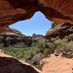
Boynton Canyon is one of Sedona's most popular hiking areas. Social Media sites like TikTok, YouTube and Instagram have really drawn a lot of attention to this canyon because of the trail to the popular Subway Cave (or Boynton Cave). Boynton Canyon is also the location of one of the four major Sedona vortexes. The Boynton Canyon trail is a moderate hike that is around 7 miles. Plan on parking on the side of Boynton Pass road as the parking lot is small and fills up quickly. I do not think the free Sedona shuttle makes a stop here. But the Boynton Canyon trail is a nice hike that passes by the Enchantment Resort and offers magnificent views of Sedona's red rocks. The trail to the Subway cave branches off of Boynton Canyon Trail. There is no sign marking the trail to the cave, but there is a makeshift marker. I just followed the crowds of people heading that way when I went. The trail to the cave is about half a mile. Once you arrive at the cave, you must climb up a narrow slit in between some sandstone walls. It is a bit difficult and there was a long line going up when I did it. Once inside, there are two ledges side-by-side with beautiful views of Boynton Canyon in the background that makes for great photos. There is usually a line on both ledges for photographs on busy days. I once saw a girl take a selfie with a large foot long Subway sandwich that she had hauled up to the cave (lol - what these IG influencers do to promote themselves). Once you are done, you can head back the way you came or check out some ruins on the right-hand side. You have to walk around a bend on the right ledge in the Subway cave to get to them. There is more space to move around and less people near the ruins. We ended up hanging out and eating our lunch at the ruins. The views of the canyon are so beautiful to take in. Overall, this is fun scenic hike. The Subway Cave itself makes for fun photos. Just be prepared to deal with a lot of tourists.

We hiked here to check out the popular Subway Cave here in the canyon. There isn't too many spots in the lot next to the trail head, but luckily Boynton Canyon Rd had some space on the side of the road to park which was only about 200 feet away from the Lot. The hike is 4.5 to 5 miles out and back. Once you're about a mile and a half in the trail there is a decent amount of tree coverage but I'd still recommend hiking with a hat and even a lightly layered hoodie to keep you covered from the sun. If you plan on going up to the Subway Cave make sure you have hiking shoes with good grip because it's a challenging climb, but not impossible as I saw two kids around the ages of 8-10 make it up there. Before heading out to the trial we watched a few YouTube videos for some pointers on getting around the trail. Once you're about half a mile from Subway Cave there are more random trails than there are signs that let you know where you're going.

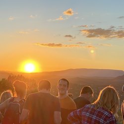
This was one of my all-time favorites.. we were in search of the four techs in this area. It was not a hard climb at all. We just followed what we thought sounded like a person playing the flute ... we followed the music, however when we got to the top, where at the Vortx was registered, the music is stopped... We stayed a little bit longer here at this site because it was very spiritual and just so pleasant ... it wasn't as windy as some of the other places, but it was gorgeous. And there was really not a lot of people. We were traveling up there around 1 o'clock in the afternoon on a Saturday. We really liked this one we recommend it ... take lots of water and sunscreen

1 month ago


2 months ago
Started this hike a little later than planned (around 10AM), but it still turned out to be such a great experience. If you're heading to the Subway Cave, I highly recommend downloading AllTrails beforehand. Once you're on the trail, it's not very clear where to turn off. We saw a few people along the way, but no one nearby when it actually mattered... which led to a little confusion. I only went off track for a few minutes, but my friends ended up going about a mile too far before turning back The hike is about 5 miles round trip. You'll spend roughly 2 miles on the Boynton Canyon Trail before reaching the turnoff for the Subway Cave. Overall, it's a pretty easy and enjoyable hike - mostly flat and shaded through beautiful forest scenery. The final stretch up to the Subway Cave involves some rock scrambling, but it's manageable. Once you're there, you've got a couple options: you can climb up to the left for an incredible view or head to the right and climb up a different way for another great vantage point. I saw some people (even toddlers!) navigating around the rocks, but personally that part felt a little nerve-racking for me. Parking fills up quickly so plan ahead. That said, there's plenty of street parking nearby off the street, and they run shuttles on weekends, which helps a lot. Definitely bring water. It can get hot, especially later in the day. Even though this is a popular hike, I didn't have to wait at all for photos. People were hanging out and soaking in the views, but it never felt crowded or rushed. Total time for me was about 2.5 to 3 hours, including time spent relaxing and exploring at the cave. Overall, such a beautiful and rewarding hike. Just don't miss that turn! read more


3 months ago
Very nice easy to moderate hike. When you drive up you'll see a lot of cars parked on the street but if you turn right to the actual entrance of the trail there is a parking lot and a restroom. Day parking is $5.00. There is a trail to follow which branches out with so many options. Absolutely gorgeous views. read more


Came around 10am and we were super lucky to get a parking spot in the lot. It's $5 and you can pay through the pay machine. Theres one restroom stall located at the lot. This was an absolutely gorgeous trail. I felt immersed into the red rock mountains. The trail has some shaded areas which is nice. A lot of the terrain is rocky so it's best to have good grip shoes. We took the detour route to get to the subway lookout. That detour was more inclined and rocky. To get to the subway lookout, you have to climb a crazy incline. There were two ways to go. One way you have more grip with big rock pieces, but you'd have to walk on a narrow edge around the mountain to get to the spot. The other way is climbing up a slipper inclined rock. It didn't have too much grip or grooves and I almost slid down a few times. The view is definitely worth it. It's an awesome spot and so cool how the rocks formed that way. There was a good amount of people, but the line wasn't long to get a picture. The way down was rough since it was slippery. I was battling with the fear of heights, but I made it! Absolutely stunning. read more


Beautiful start to a wonderful day of hiking with my best friend and partner. We started this one because it's known to be the heart of all the Vortex energy Hikes. We did knock out all the vortex hikes. This is a relatively easy hike, they have a bathroom and also parking. Again spots fill fast so grab what you see first. Make sure you get your hiking pass before hand. The views from the top are amazing and they had markers along the way so you did not get lost. In all try this hike out it's pretty amazing read more


I got here around 7:15am and the main parking lot was already full. There was still plenty of parking on the side of the road though. I did the shorter Boynton Vista Trail that led to a vortex. You are also rewarded with a nice view. It was an easy hike with a little climbing of rock steps in the end. If I was to return to Sedona, I will have to attempt the Subway Cave next time! read more


Boynton Canyon Trail is one of the true jewels of the greater Sedona region. Not only does it take you to one of the essential vortexs of the area, but throughout its entire span you see beautiful, topography, great rock formations, plant, and wild life. It's truly an inspiring trail to walk upon. Located just outside of central Sedona, this trail is fairly easy to get to. It does have a main parking lot set up for you to park your car. But, it's important to note that this parking lot fills up quickly. In this case, your best bet is to park down the side of the road, just a bit away from the trailhead, There, you can oftentimes find parking. Keep in mind, however, this is a popular trail, so sometimes you may have to park as far as a mile away to even get to it on weekends and during the summer holidays. This is not a hard trail to hike upon, for those of you who don't like intense strenuous activities. Yes, there is some up and down, and it does transverse fora long range. But, if you take your time, you should have no trouble, enjoying the beauty that you will take in while walking on this trail. Overall, this is one of my favorite hiking spots in Sedona. Rain or shine, it is always a beautiful place to take in the scenery, breathe some very clean air, get your exercise on, and take in all of the great and vital energy that Sedona has to offer. read more


1 year ago
Boyton Canyon was one of the more unique Arizona Trails we experienced, as it offered a variety of different terrains to explore- Starting off with an easy flat path dessert walk, leading to an inclined path with gorgeous backdrop views of rock formations & mountain peaks- I kept wondering if the path was going to lead up a mountain with some bouldering, but it merely wove around- it transcended through villa homes & resorts, giving less private nature beauty, but still scenic Eventually, the signage died out & we lost our directional awareness, but this worked to our advantage as we stumbled upon other hikers, we followed them to what we thought was Boyton Canyon continued, but was actually the Subway Cave- The cave was an amazing side trip. The scramble up the 'subway' was quite a thrilling challenge- then tiptoeing around the rock edges to the historic rock formation cave walls, offered the most tranquil views of natural beauty- After exploring the cave & nearby rock edges, we finished along Boyton Canyon- which changed into an eerie haunted forest vibe with deep wilderness, thick trees- the temperature dropped about 10degrees entering this portion and the air thinned out- But the end of Boyton was anticlimactic-nothing, I think compared to some photos we saw online they shorted the end of the trail recently for reforestation conservation Overall a great hike- highly recommend read more


2 years ago
Plan according if you plan to do the full hike to the end of the canyon or just to Subway. Figure total 7+ miles to do both the canyon end and the cave. Subway is a right hand turn off with NO sign just a big Juniper Tree. You should see a well worn track to the right on your way out. A god healthy climb to the subway cave. If you want the easy way up avoid the chute straight up and take the more steep trail to the left. read more


Amazing beauty and historical significance with many undocumented sites to discover on your own, it all depends on how much time you have... Make sure to respect and be careful around all ruins so they can be enjoyed in the future by others. read more


7 months ago
Pretty excellent trail -if you're into hiking to energy vortexes. The views are amazing and it's a surprisingly short height. Highly recommended read more


I hiked Boynton canyon trail to the subway cave and the views were incredible! There's no sign for turn to the cave but there's a large rock arrow. The chute to get up the cave is a bit spooky but there's also a trail to the left you can take instead. The parking lot is small and requires a red rock pass or America the beautiful pass but there's some roadside parking for free. read more


My boyfriend and I hiked this trail to the "secret" cave in June. The first 2 miles of the hike were very hot with little shade, but great views of the rocks. It wasn't very difficult aside from the heat of the sun. The hike got more interesting when we turned off for the cave. Once you start climbing up those big, beautiful rocks, the view is stellar! We had a great time. I'm an avid hiker. My boyfriend is a beginner. We were both able to complete the hike to the cave and back (about 5 miles) with little issue. He needed a break after we climbed up to the viewpoint, but aside from that he was a-ok! read more


Boynton Canyon is one of Sedona's most popular hiking areas. Social Media sites like TikTok, YouTube and Instagram have really drawn a lot of attention to this canyon because of the trail to the popular Subway Cave (or Boynton Cave). Boynton Canyon is also the location of one of the four major Sedona vortexes. The Boynton Canyon trail is a moderate hike that is around 7 miles. Plan on parking on the side of Boynton Pass road as the parking lot is small and fills up quickly. I do not think the free Sedona shuttle makes a stop here. But the Boynton Canyon trail is a nice hike that passes by the Enchantment Resort and offers magnificent views of Sedona's red rocks. The trail to the Subway cave branches off of Boynton Canyon Trail. There is no sign marking the trail to the cave, but there is a makeshift marker. I just followed the crowds of people heading that way when I went. The trail to the cave is about half a mile. Once you arrive at the cave, you must climb up a narrow slit in between some sandstone walls. It is a bit difficult and there was a long line going up when I did it. Once inside, there are two ledges side-by-side with beautiful views of Boynton Canyon in the background that makes for great photos. There is usually a line on both ledges for photographs on busy days. I once saw a girl take a selfie with a large foot long Subway sandwich that she had hauled up to the cave (lol - what these IG influencers do to promote themselves). Once you are done, you can head back the way you came or check out some ruins on the right-hand side. You have to walk around a bend on the right ledge in the Subway cave to get to them. There is more space to move around and less people near the ruins. We ended up hanging out and eating our lunch at the ruins. The views of the canyon are so beautiful to take in. Overall, this is fun scenic hike. The Subway Cave itself makes for fun photos. Just be prepared to deal with a lot of tourists. read more


We hiked here to check out the popular Subway Cave here in the canyon. There isn't too many spots in the lot next to the trail head, but luckily Boynton Canyon Rd had some space on the side of the road to park which was only about 200 feet away from the Lot. The hike is 4.5 to 5 miles out and back. Once you're about a mile and a half in the trail there is a decent amount of tree coverage but I'd still recommend hiking with a hat and even a lightly layered hoodie to keep you covered from the sun. If you plan on going up to the Subway Cave make sure you have hiking shoes with good grip because it's a challenging climb, but not impossible as I saw two kids around the ages of 8-10 make it up there. Before heading out to the trial we watched a few YouTube videos for some pointers on getting around the trail. Once you're about half a mile from Subway Cave there are more random trails than there are signs that let you know where you're going. read more


3 years ago
This was one of my all-time favorites.. we were in search of the four techs in this area. It was not a hard climb at all. We just followed what we thought sounded like a person playing the flute ... we followed the music, however when we got to the top, where at the Vortx was registered, the music is stopped... We stayed a little bit longer here at this site because it was very spiritual and just so pleasant ... it wasn't as windy as some of the other places, but it was gorgeous. And there was really not a lot of people. We were traveling up there around 1 o'clock in the afternoon on a Saturday. We really liked this one we recommend it ... take lots of water and sunscreen read more


The trail is easily the best trail in Sedona! It's a canyon trail with abundant trees so the temperature tends to be cooler. It's a very clear path so you won't get lost easily. It's a long walk but it's filled with numerous views and the end is spectacular. When you get to the canyon climb, you have the opportunity to scramble up a rather steep rock but it's totally worth it. Plus, there are some ruins located around the side if you are brave enough to walk over there. I'd recommend going early in the morning for a good parking spots and the best temperatures. read more


How lucky are we that live in the valley to have Sedona just a short car ride way. Sedona is beautiful and known worldwide for its red rocks, and Sedona has many hiking trails to explore and that's my goal this year to explore more trails. On this trip I knew I wanted to check out the Subway Cave, its within the Boynton Canyon Trail, Boynton Canyon Trail is one of the most scenic of the box canyons, it's also one of the four Sedona vortexes, It wraps around the Enchanted Resort. The trailway leading to the subway cave is apx 2ish miles in, there is no clear marker, some people do set up stones to point an arrow in the direction to turn but as we were coming up on that a group of hikers destroyed it. I don't know why people feel the need to ruin things lol anyways, If you miss the turn off for the subway cave, which can be done, know if you are still on Boynton Canyon trail and your in the middle of lots of pine trees you have gone too far. As you can guess we went to far, we almost finished Boynton Canyon Trail, which wasn't even bad, it's a beautiful Zen hike how you can be mad. We turned around and saw where we missed the turn for the hike and made our way up. Now to get to see the Subway Cave you do have to climb up some rocks and some parts are steep, but don't let that discourage you. The views of this hike 10000 out of 10! Glad to have made it out on this trail! Total mileage when done over 9 miles but like I said we missed our turn for the subway trial the 1st time by. read more


1 year ago
2 years ago
Once we found the Subway Cave it was all worth the trip! What an amazing and beautiful sight to see! We actually missed the unmarked turn to the cave and did the whole entire hike! Man, what a mistake to make right? LOL! I'm very proud of us for making it but it would have been much shorter had we known where we were actually suppose to go! They say the Subway Cave is one of the many vortexes to find in Sedona! Doing the whole hike kept us out double the time but I'm glad we didn't give up. What's funny is that we asked every single person we passed if we were close and what we were looking for and they didn't mention it was unmarked until we were on the way back! What a hike! Haha! So worth it but next time we will know exactly where to turn off! read more


2 years ago
great little trail easy to moderate skill necessary and soft powdery uneven trail floor. There were rocks as big as your head that you have to walk on top of for a short period of the trail, as well as climbing/lunging some fairly large stairs. You have to be able to lift your leg at least a foot and a half. I would not say this trail is handicap accessible or for anyone with any walking disabilities as the trails do become curved/narrowed at some times. But OVERALL, it's pretty great in the scenery and rotation of forms of walking/climbing it puts your body through. It was everything we were looking for as beginners. I'd say a mile and a half to where we are pictured at top of mountain. You can go further if your more experienced then us obviously! But I suggest some real hiking/climbing gear. Happy hiking!! read more


Absolute must do hike when in Sedona, this is my number 1 pick! So, I had see the photos for this trail and it was in my top 2 must hiked for Sedona this short trip. Word of advice, AllTrails map helps for Boyton Trail but there is no map for Subway Cave, I used a blog I found online to find this. Fortunately, there was many people on the route which helped as well :) Boyton loop is a very calm scenic trail, and it's hard to imagine this being in AZ. There was streams of water and the vortex was cool. I did not feel anything major, just peaceful. I'd recommend packing plenty of water and maybe a light lunch to enjoy at the top. The Subway cave can be accessed about 2 mi into the trail (so, you did this before completing the loop). We totaled 9 miles - AllTrails said 6 0_0 The cave was absolutely worth it but does require some scrambling (small climbing). The views are incredible, I absolutely recommend! *Tip: Add Subway Cave, you will not regret it read more


One of the best hikes I have ever done. I have been to the end and there is a huge pile of rocks, there is a little scrambling, but not too bad. Well marked trail. Parking is limited. There is a fee machine. Dogs were in the trail. There are some narrow spots bring a mask. It can be slippery after it rains wear proper footwear. There are ruins please don't disturb them and a subway rock formation that can be dangerous. Use caution and common sense it's not worth falling to get that selfie. If you are hiking along ask someone to take your photo bring sanitizer to clean phone, be safe. read more

Did the subway and LOVED it! Trail is a bit confusing, follow it from the parking lot past the Enchantment Resort about 2 ish miles and there will be a large sandy opening area with a log off to the right, which you will step over to proceed to the subway. After that the trail is fairly easy to follow through brush, and you will need to climb up to the subway, it's a bit steep. read more


5 years ago
Amazing 5 star hike. There is a not so secret spot called the subway cave that is definitely worth it to hike to. Bring plenty of water and a snack. The subway cave is about like 3 miles into the hike . . You go off the trail a bit. There were plenty of other hikers so we were able to navigate pretty easily. You can also see ruins at the cave. It was breathtaking. read more


The most beautiful trail I have hiked thus far in life, and I hike a lot. The trail is popular and has many sub-trails. If you are trying to do the Subway Cave, which I recommend to all, follow the All Trails Map careful ly, as it is easy to get lost. While there are many parking spots, Boynton is popular, and most are gone by 8AM, so arrive early. Parking is $5 in cash or free if you have the Sedona Parking Pass ($40 for a year and is valid for all trails). The trail is a mix of shade and sun with mostly dirt but some rock terrain as well. Overall, do yourself a favor and hike this lovely trail :) read more


The Boynton Canyon Trail is a challenging hike with narrow paths and beautiful scenery. There are clearly marked trail markers along the way to guide you along the several miles of rocky trails amidst the unique red rock geological formations. After I started walking I experienced some of Sedona's famous vortex energy when my phone's music app unexpectedly turned on and started playing music. I was surprised because my phone indicated I had no internet connection and it was in my zipped pouch. Coincidentally this also happened the day before at Bell Rock. Midway on my hike, I encountered two deers who seemed serenely comfortable with my presence and continued eating their meal while I was taking their pictures. There are beautiful views and the world famous Enchanted Resort is clearly visible. Using my Fitbit, I easily got into "fat burn" mode and was sweating the whole way while navigating the inclines and rocky terrain. My parking pass cost $5 and there were plenty of spots available. read more


6 years ago
This is fairly short trail, located in Boynton Canyon. Compared to the other hikes in Sedona, this area has much more vegetation, trees, spiky plants, and cactus. I would highly recommend going to the Vortex mountains, with male and female energy vortexes. Short overall hiking, but challenging if you want to climb to the tops of these formations. read more


It is pretty long trail if you start from the parking lot to the subway cave as the end point. We stayed at Enchanment resort so we get direct access to the trail. I hiked to the Boynton Vista trail/Boynton Pass Vortex the first day and the Subway cave the second day. 1. From Enchantment resort to Boynton vista trail/Boyton Pass Vortex: about 2 mile round trip. From parking to Boyton vista, it is about 1 1/2 mild RT. It is easy to moderate. The most part is not shaded. From the trail to go up hill to the vista/ vortex, it is a bit rocky uphill but is doable. At the top, you have a good view. The man plays flute at the top of the rock everyday. It is quite nice and relaxing. This vortex is supposed to be one of the strongest one in Sedona, with both feminine and masculine energy. Some claim they can feel the vibration of the rocks and energy flowing... did I feel it? Nope, just my legs shaking from wind and elevation! For this part of the trail, it is good for all ages. 17 oz water bottle (1/2L) is good per person. 2. Subway cave trail: From Enchantment resort, it is about 3 + mile RT. From parking, it is about 5 mile RT. This part is moderate to difficult. It is mostly shaded. The first half of the trail is easy strolling with many wildflowers, very pretty. After the red dirt trail, the trail splits, keep right. There is mark on the ground at the big tree to mark the last 1/2 and more rocky uphill part. Keep on right side, pass the ravine, hike uphill along some big windy trees, turn sharp right against the rock wall, continuing up. This part is tricky and easy to get lost. The good thing is many hikers around... so I just ask other hikers and following them. I did download Altrail app map and still got lost! At the caves, you can climb up on the left side to some big caves and ruins. Some people get to the subway cave from there. However, it is very narrow cliff... and I'm no spiderman! On the right side, you have to climb up the slippery straight up cliff to get to subway cave. It is pretty amazing view from both sides. This part is not good for young children and older folks. If you are hiking alone, try to hike during peak hours so you can get some hikers help spotting you to climb up and down. I would recommend good tracking shoes and at least 1L water per person. Overall, it is a nice trail but it is not one of my favorite ones (not comparing to Zion or Napali coast or Lanikai pillbox). read more


Honestly, all the trails in Sedona are fantastic! If you are looking for a long easy hike with shade and forest, this would be the hike for you. My friend and I specifically chose to hike on a weekday (Thursday to be exact) to avoid the crowds. It so happened the few days we were in Sedona it was well into the 90's in temperature. We got to the trailhead, which to keep in mind you pay a parking fee. The lot was full but we managed to find spots to park around the corner. Trail signage was very clear, lots of shade so the heat was not bad, though bring water and a snack, it is about 7-8 miles round trip. Beautiful views. It's a great hike! read more


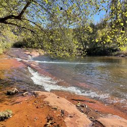
Great trail. About 5-6 mile round trip. I went in August and there was no water in the stream. Luckily there were shades and canopy so it wasn't as bad. Took us about 4 hours hiking, with an 8 years old. Most of the trail was flat but rocky. View at end of trail was decent but I know there are better views out there. The great point is that we saw plenty of wild life: rattle snake, lizards, butterflies, deer. That was pretty cool. Oh and do not use the directions on yelp. Takes you to the parking lot for devil's bridge. Just go to Map and look up Boyton canyon trail head. read more


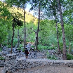
The leaves were turning when we did this in early November, and that helped make this a 5 star hike. Some beautiful scenery that at points reminded me of Yosemite (no other hike in Sedona had the style of views that this one had). It ends in a huge rock formation that a local told me is the largest energy vortex in Sedona... I don't know anything about energy vortexes, but I can tell you that the view at the end of the trail was beautiful and tranquil. A great place to just hang out and soak in all the surrounding natural beauty. The entire trail was shaded on the way up, which the dogs loved. However, given the angle of the sun on the way back there was plenty of sun on the last 25% of the route. Dog Owners beware: We twice experienced wild Javelinas on this trail, which sent our dogs into a frenzy. We didn't experience any problems because they were on leash, but an off leash dog might have charged them, and then all hell would have broken loose. read more


2 years ago
Hiked on 5/8 & other trails during a Phoenix & Sedona trip & posted a vlog! Search "Nikko Gandia Travels Sedona" on YouTub3. The subway cave can be reached via trail split. Recommend making the cave your endpoint, unless you want the mileage, views at the end of the actual trail are not as spectacular as the cave. Get the 7 day Red Rock Parking Pass at the machine if you're doing a multi-day Sedona trip, most trails require it. read more


4 years ago
It was supposed to be a 30 minutes hike . but we took a wrong trail and total was a 3 hours hike . we had to go to "Vista" at the sign to go to a vortex . But we enjoyed the hiking anyway . read more


The hike along Boynton Canyon Trail was easy to moderate. The hike to the cave was moderate to hard. Parking is good for the first 20 vehicles (approximately). There is a fee. There is a restroom... Unisex loo. It does stink. we didn't find a hand sanitiser. There are plenty of toilet paper during the first half of the day. Must bring more than enough water, electrolytes, and energy bar or snack. SUGGESTIONS:. 1- bring your own wipes or tp 2- bring your own hand sanitiser. 3- arrive before 0800 for parking spot and less crowded along the trail 4- trail to the cave, not recommended for children under 12 5- leash the pups at all times 6- be mindful of other hikers... The trail narrows down. Please share the trail responsibly. . read more


To say the views from the cave or the top of hike aren't beautiful is an understatement. We spent most of our Saturday here exploring and enjoying nature. While some parts of the trail were crowded we took our time, waited out the crowds and enjoyed a wonderful place. We will definitely be back. read more


Page 1 of 3
More info about Boynton Canyon Trail
Boynton Canyon Trl
Sedona, AZ 86336
Directions
Visit Website
https://www.fs.usda.gov/recarea/coconino/recarea/?recid=55242
Hours
Indoor Amenities
Outdoor Amenities
Boynton Canyon Trail Reviews in Other Languages
Ask the Community - Boynton Canyon Trail
Review Highlights - Boynton Canyon Trail


Why does Yelp recommend reviews?
1 review that is not currently recommended
The reviews below are not factored into the business's overall star rating.
12 years ago
Boynton Canyon Trail - hiking - Updated May 2026
Best of Sedona
People found Boynton Canyon Trail by searching for…
Trending Searches in Sedona, AZ
Boat Rental near Boynton Canyon Trail
Botanical Gardens near Boynton Canyon Trail
Bounce House Rentals near Boynton Canyon Trail
Campgrounds near Boynton Canyon Trail
Cliff Jumping near Boynton Canyon Trail
Dog Friendly Things To Do near Boynton Canyon Trail
Flower Fields near Boynton Canyon Trail
Flower Shop near Boynton Canyon Trail
Garage Sales near Boynton Canyon Trail
Garden Center near Boynton Canyon Trail
Hair near Boynton Canyon Trail
Lakes & Ponds near Boynton Canyon Trail
Nurseries & Gardening near Boynton Canyon Trail
Outdoor Activities near Boynton Canyon Trail
Outdoor Furniture Stores near Boynton Canyon Trail
Parks near Boynton Canyon Trail
Party Equipment Rentals near Boynton Canyon Trail
Pedicure near Boynton Canyon Trail
Pick Your Own Farms near Boynton Canyon Trail
Picnic Areas near Boynton Canyon Trail
Places To Take Pictures near Boynton Canyon Trail
Running Trails near Boynton Canyon Trail
Rv Rental near Boynton Canyon Trail
Scenic Drive near Boynton Canyon Trail
Secret Spots near Boynton Canyon Trail
Sunrise View near Boynton Canyon Trail
Swimming Holes near Boynton Canyon Trail
Table And Chair Rentals near Boynton Canyon Trail
Browse Articles
Browse Nearby
BEST of Sedona, Arizona Things to Do near Boynton Canyon Trail
BEST of Sedona, Arizona Coffee near Boynton Canyon Trail
BEST of Sedona, Arizona Breakfast near Boynton Canyon Trail
BEST of Sedona, Arizona Restaurants near Boynton Canyon Trail
BEST of Sedona, Arizona Horseback Riding near Boynton Canyon Trail
Browse Brands
Related Searches in Sedona, AZ
Affordable Kayak Rental Services in Sedona, Arizona
Best Fishing Locations and Guides in Sedona, Arizona
Best Places for Horseback Riding in Sedona, Arizona
Best Waterfalls and Swimming Holes in Sedona, Arizona
Check Out Off Road Trails in Sedona, Arizona
Discover Dog Friendly Trails to Explore in Sedona, Arizona
Discover Kid Friendly Hiking Trails in Sedona, Arizona
Discover Scenic Mountain Bike Trails Near Sedona, Arizona
Discover Scenic Waterfall Spots in Sedona, Arizona
Discover a Hiking Trail in Sedona, Arizona
Discover the Best Night Hike Trails in Sedona, Arizona
Dog-Friendly Hikes With Dogs in Sedona, Arizona
Enjoy Camping Adventures Around Sedona, Arizona
Enjoy Exciting Mountain Biking Adventures in Sedona, Arizona
Enjoy Kayaking Adventures in Sedona, Arizona
Enjoy Tent Camping Spots Around Sedona, Arizona
Enjoy the Best Picnic Spots and Ideas in Sedona, Arizona
Enjoy the Best Walking Trails in Sedona, Arizona
Exciting Cliff Jumping Spots in Sedona, Arizona
Experience Thrilling White Water Rafting in Sedona, Arizona
Explore Beautiful Parks and Green Spaces in Sedona, Arizona
Explore Bike Rentals Throughout Sedona, Arizona
Explore Easy Hikes Perfect for All in Sedona, Arizona
Explore Fun Activities to Do in Sedona, Arizona
Explore Popular Campgrounds Near Sedona, Arizona
Explore Top Dog Parks in Sedona, Arizona Near You
Explore the Best Boating Spots in Sedona, Arizona
Explore the Best Swimming Holes Around Sedona, Arizona
Explore the Best Trail Options in Sedona, Arizona
Family Friendly Hiking With Kids in Sedona, Arizona
Find Beautiful Views in Sedona, Arizona
Find Parks and Recreation Activities in Sedona, Arizona
Find Popular Ziplining Spots Around Sedona, Arizona
Find the Best Parks for Picnics in Sedona, Arizona
Find the Best Scenic View Locations in Sedona, Arizona
Hiking Trails With Waterfalls in Sedona, Arizona
Off Leash Dog Hiking Trails in Sedona, Arizona
Plan a Scenic Drive Route Near Sedona, Arizona
Popular Fishing Spots to Explore in Sedona, Arizona
Popular Outdoor Activities to Try in Sedona, Arizona
Popular Picnic Spots to Visit in Sedona, Arizona
Popular Things to Do in Sedona, Arizona
Safe River Swimming Areas in Sedona, Arizona
Safe and Fun Parks for Kids in Sedona, Arizona
Top Climbing Spots and Gyms in Sedona, Arizona
Top Running Trails to Explore in Sedona, Arizona
Top Swimming Spots and Pools in Sedona, Arizona
Top Things to Do With Kids in Sedona, Arizona