Blodgett Canyon Photos


More like Blodgett Canyon
Recommended Reviews - Blodgett Canyon
Start your review...


3 years ago
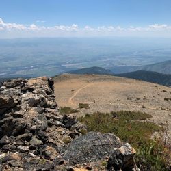
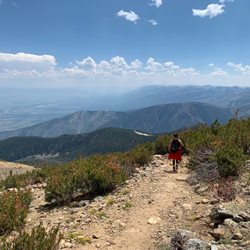
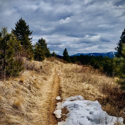
What a beautiful hike and way to spend some time enjoying nature! For the overlook trail, you are mostly going up hill the whole time so be prepared for a bit of an incline. The trail has a lot of trees so a good portion of it is shaded, but parts are still in the sun. Depending on the time you come, this trail gets pretty busy so be prepared for that. There is a nice opening spot up top so you can hangout and enjoy the views. I recommend packing a lunch or little picnic to enjoy up there before heading back down. read more


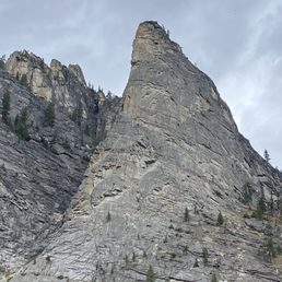
Really cool hike with a gradual elevation that's surrounded by tall trees, wooded shrubs, flowers and rock, both below, around and above. After about a mile and a half you're rewarded with a crystal clear spring fed pond with a mountain backdrop. read more


3 years ago
It's a nice and somewhat easy hike to the top of the overlook. A drive up can be a little scary for those not used to that sort of situation. read more


3 years ago
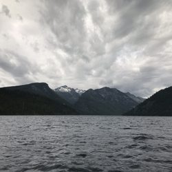
Fantastic trail with sights of mountains, creek and beaver damn. Also cross creek to take some of the lesser traveled trails, walk through valleys and along water way read more


Great scenery | Good for backpacking Quick Points: -Backpacking trip of 16 miles total -Beautiful place, lots of wildlife, good terrain -Enough distance to travel to pick your stops and breaks -Tips: be bear aware and suggested items to bring We visited my fiancee's cousins in Missoula and knew we were going to go backpacking for 3 to 4 days. I was scared of the idea of being in grizzly bear country, but after they made me watch documentaries on grizzly bears in Glacier National Park, I became terrified of the backpacking trip. We picked out our trail and decided to hit up Blodgett Canyon, which seemed like a good beginner - intermediate backpacking trail. Apparently, this is a very popular trail that is traveled often, so it is extremely rare to find a bear wandering around here. Gorgeous hiking area. We did this trip in the summer, so the weather was pretty warm. There were a couple of areas that got the heart pumping, but it wasn't a consistent steep grade. It was more flat with a couple of scrambles. I'm also pretty sure that there was a stream we followed as well. We hiked for 8 miles that led to a big clearing and a waterfall. We decided that since it was only a 3-day trip, we'd just camp out here and enjoy relaxation after hiking for 6 - 8 hours. At this area, we saw a moose and its baby, no bears, and had a whole lot of mosquitos around. We hiked the 8 miles back and enjoyed this trip. I highly recommend this trail for anyone who is a beginner to an intermediate level backpacker. TIPS: -bring bear proof cans -garbage bags -shovel (to shovel a hole for your poop) -bug repellent -sun screen -a bell (when you hike, you don't want to startle any wildlife. they can hear you from far away) -hiking stick/trekking poles -bear spray **we had walkie talkies because we wanted to roam around. so, in case anyone was lost or needed help a short distance away, we could communicate with each other** read more


14 years ago
More info about Blodgett Canyon
Blodgett Camp Rd
Hamilton, MT 59840
Directions
Hours
Outdoor Amenities
Ask the Community - Blodgett Canyon


Blodgett Canyon - hiking - Updated July 2026
Best of Hamilton
People found Blodgett Canyon by searching for…
Things to Do in Hamilton, Montana
Campgrounds in Hamilton, Montana
Waterfall Hike in Hamilton, Montana
Natural Hot Springs in Hamilton, Montana
Parks for Kids in Hamilton, Montana
Hiking Trails in Hamilton, Montana
Picnic Areas in Hamilton, Montana
Beautiful Views in Hamilton, Montana
Easy Hikes in Hamilton, Montana
Camping Sites in Hamilton, Montana
Walking Trails in Hamilton, Montana
Day Trips in Hamilton, Montana
Picnic Parks in Hamilton, Montana
Waterfalls in Hamilton, Montana
Scenic Views in Hamilton, Montana
Hiking Trails Kid Friendly in Hamilton, Montana
Lakes & Ponds in Hamilton, Montana
Tent Camping in Hamilton, Montana
Canyoneering in Hamilton, Montana
Nature Parks in Hamilton, Montana
Trending Searches in Hamilton, MT
Browse Articles
Browse Nearby
Browse Brands
Related Searches in Hamilton, MT
Best Fishing Locations and Guides in Hamilton, Montana
Best Places for Horseback Riding in Hamilton, Montana
Best Places for Stunning Views in Hamilton, Montana
Best Waterfalls and Swimming Holes in Hamilton, Montana
Check Out Off Road Trails in Hamilton, Montana
Discover Lakes & Ponds to Explore in Hamilton, Montana
Discover Popular Bike Trails in Hamilton, Montana
Discover Popular Photo Spots in Hamilton, Montana
Discover Scenic Creeks to Explore in Hamilton, Montana
Discover Top Nature Parks to Visit in Hamilton, Montana
Discover a Hiking Trail in Hamilton, Montana
Enjoy Exciting Mountain Biking Adventures in Hamilton, Montana
Enjoy Tent Camping Spots Around Hamilton, Montana
Enjoy the Best Picnic Spots and Ideas in Hamilton, Montana
Explore Beautiful Parks and Green Spaces in Hamilton, Montana
Explore Fun Activities to Do in Hamilton, Montana
Explore Popular Campgrounds Near Hamilton, Montana
Explore Popular RV Parks Around Hamilton, Montana
Explore Scenic Lakes to Visit in Hamilton, Montana
Explore the Best Trail Options in Hamilton, Montana
Family Friendly Hiking With Kids in Hamilton, Montana
Find Beautiful Views in Hamilton, Montana
Find Cozy Camping Cabins in Hamilton, Montana
Find Picnic Tables for Outdoor Fun in Hamilton, Montana
Find the Best Playgrounds to Visit in Hamilton, Montana
Find the Best Scenic View Locations in Hamilton, Montana
Great Places to Swim in Hamilton, Montana
Locate a Public Shower Facility in Hamilton, Montana
Must-See Tourist Attractions Around Hamilton, Montana
Plan Nature Center Visits in Hamilton, Montana
Popular Fishing Spots to Explore in Hamilton, Montana
Popular Kids Activities in Hamilton, Montana
Popular Picnic Spots to Visit in Hamilton, Montana
Popular Places to Take Pictures in Hamilton, Montana
Popular Things to Do in Hamilton, Montana
Popular Things to See in Hamilton, Montana
Relax at Natural Hot Springs Near Hamilton, Montana
Safe River Swimming Areas in Hamilton, Montana
Top Fishing Charter Experiences in Hamilton, Montana
Top Places to Visit in Hamilton, Montana for Sightseeing
Top Playgrounds for Kids to Enjoy in Hamilton, Montana
People who viewed Blodgett Canyon also viewed
Bear Creek Overlook
3 reviews
Lee Metcalf National Wildlife Refuge
4 reviews
St Mary’s Peak Trailhead
2 reviews
TroutZoola Montana Fly Fishing
3 reviews
Moose Creek Outfitters
1 review
Trapper Peak Outfitters & Guest Lodge
2 reviews
Montana Hunting & Fishing Adventures
1 review
Ravalli Fun Center
10 reviews
Majik Arabians
1 review
Hamilton Golf Course
3 reviews