Big Walnut Nature Preserve Photos


More like Big Walnut Nature Preserve
Recommended Reviews - Big Walnut Nature Preserve
Start your review...

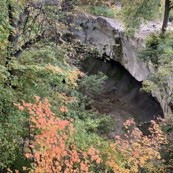
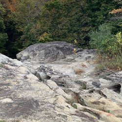
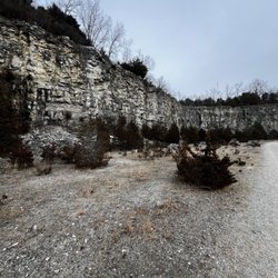
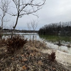
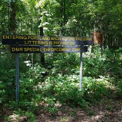
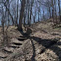
Big Walnut aka Fortune Woods is a nature preserve with an excellent ~2 mile long looping trail through very scenic old growth woods. The paths are wide and flat, with the most rugged aspect being the several flights of nice, sturdy stairs you will have to climb in a few parts. The trail also branches off over to a creek - which looks like you could climb down by if you wanted to get wet and muddy. We live in Indy and it took about 40 minutes for us to get out there and find it. The trail didn't take us long, and that is all that's really out there (no picnic tables or restrooms), so the driving took longer than the hiking, but it was extremely peaceful and relaxing. We took the mutt and he was thrilled! The trail is shady and so we kept cool the entire time, which was a plus for the dog. If you are out that way, or just want to take a relaxing roadtrip, I'd highly recommend going over to Big Walnut, but it isn't worth it just to go there for the day. read more


More info about Big Walnut Nature Preserve
Bainbridge, IN
Directions
Hours
Outdoor Amenities


Big Walnut Nature Preserve - hiking - Updated May 2026
Best of Bainbridge
People found Big Walnut Nature Preserve by searching for…
Things to Do in Bainbridge, Indiana
Scenic View in Bainbridge, Indiana
Sunset View in Bainbridge, Indiana
Hiking Trails in Bainbridge, Indiana
Scenic Drive in Bainbridge, Indiana
Walking Trails in Bainbridge, Indiana
Scenic Overlook in Bainbridge, Indiana
View Points in Bainbridge, Indiana
Beautiful Views in Bainbridge, Indiana
Stair Climbing in Bainbridge, Indiana
Off Road Trails in Bainbridge, Indiana
Scenic Restaurants in Bainbridge, Indiana
Waterfalls in Bainbridge, Indiana
Off Leash Dog Hikes in Bainbridge, Indiana
Photo Spots in Bainbridge, Indiana
Places to Take Pictures in Bainbridge, Indiana
Scenic Spots in Bainbridge, Indiana
Lookout Points in Bainbridge, Indiana
Running Trails in Bainbridge, Indiana
Picnic Areas in Bainbridge, Indiana
Fitness & Instruction in Bainbridge, Indiana
Trending Searches in Bainbridge, IN
Browse Articles
Browse Brands
Related Searches in Bainbridge, IN
Best Lookout Points to Visit in Bainbridge, Indiana
Best Nature Trails for Hiking in Bainbridge, Indiana
Best Places for Stunning Views in Bainbridge, Indiana
Check Out Off Road Trails in Bainbridge, Indiana
Discover Dog Friendly Trails to Explore in Bainbridge, Indiana
Discover Popular Bike Trails in Bainbridge, Indiana
Discover Popular Photo Spots in Bainbridge, Indiana
Discover Scenic Creeks to Explore in Bainbridge, Indiana
Discover Scenic Mountain Bike Trails Near Bainbridge, Indiana
Discover Stunning Skyline View Spots in Bainbridge, Indiana
Discover Top Nature Parks to Visit in Bainbridge, Indiana
Discover a Hiking Trail in Bainbridge, Indiana
Discover the Best Night Hike Trails in Bainbridge, Indiana
Discover the Best Running Track in Bainbridge, Indiana
Dog-Friendly Hikes With Dogs in Bainbridge, Indiana
Effective Stairs Workout Spots in Bainbridge, Indiana
Enjoy Scenic Night View Experiences in Bainbridge, Indiana
Enjoy the Best Picnic Spots and Ideas in Bainbridge, Indiana
Enjoy the Best Walking Trails in Bainbridge, Indiana
Experience Stunning Sunset Views in Bainbridge, Indiana
Explore Easy Hikes Perfect for All in Bainbridge, Indiana
Explore Nature Spots Around Bainbridge, Indiana
Explore Parks With Pull Up Bars in Bainbridge, Indiana
Explore Popular Campgrounds Near Bainbridge, Indiana
Explore Popular Scenic Overlook Points in Bainbridge, Indiana
Explore Popular View Points Around Bainbridge, Indiana
Explore Secret Spots Worth Visiting in Bainbridge, Indiana
Explore the Best Swimming Holes Around Bainbridge, Indiana
Explore the Best Trail Options in Bainbridge, Indiana
Find Beautiful Views in Bainbridge, Indiana
Find Parks and Recreation Activities in Bainbridge, Indiana
Find the Best Fireworks Shows in Bainbridge, Indiana
Hiking Trails With Waterfalls in Bainbridge, Indiana
Off Leash Dog Hiking Trails in Bainbridge, Indiana
Perfect Spots to Watch Sunset in Bainbridge, Indiana
Plan Nature Center Visits in Bainbridge, Indiana
Plan a Scenic Drive Route Near Bainbridge, Indiana
Popular Places to Take Pictures in Bainbridge, Indiana
Popular Things to Do in Bainbridge, Indiana
Safe River Swimming Areas in Bainbridge, Indiana
See Top Fireworks Events in Bainbridge, Indiana
Top Running Trails to Explore in Bainbridge, Indiana
Uncover the Best Secluded Spots Around Bainbridge, Indiana
People who viewed Big Walnut Nature Preserve also viewed
Burnett Woods Nature Preserve
2 reviews
Pleasant Acres Nature Park
2 reviews
Sugar Creek Nature Park
2 reviews
White Lick Creek Trail
5 reviews
Pine Hills Nature Preserve
1 review
Zionsville Rail Trail
9 reviews
Vandalia Trail - Coatesville Trailhead
1 review
Jaycee Park
1 review
W S Gibbs Memorial Park
2 reviews
Vandalia Rail Trail
6 reviews