Aviation Navigation Arrow Photos


More like Aviation Navigation Arrow
Recommended Reviews - Aviation Navigation Arrow
Start your review...

2 years ago
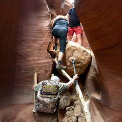
Embark on this breezy trek--perfect trail if you've got the green light post-injury or just diving into the fitness game. It's a delightful challenge with valley views that'll make your heart skip a beat. Stumble upon a century-old cement arrow, oddly out of place, accompanied by a quirky plaque detailing a charming marriage proposal tale for some extra laughs! read more


More info about Aviation Navigation Arrow


Aviation Navigation Arrow - landmarks - Updated July 2026
Best of St. George
People found Aviation Navigation Arrow by searching for…
Scenic Drive in St. George, Utah
View Points in St. George, Utah
Scenic View in St. George, Utah
Free Things to Do in St. George, Utah
Places to Take Pictures in St. George, Utah
Walking Trails in St. George, Utah
Public Services & Government in St. George, Utah
Hidden Gems in St. George, Utah
Photo Spots in St. George, Utah
Hiking Trails in St. George, Utah
Observation Deck in St. George, Utah
Date Ideas in St. George, Utah
Scenic Overlook in St. George, Utah
Historical Sites in St. George, Utah
Tourist Attractions in St. George, Utah
Sightseeing in St. George, Utah
Night View in St. George, Utah
Field Trips in St. George, Utah
Watch Sunset in St. George, Utah
Fun Things to Do in St. George, Utah
Trending Searches in St. George, UT
Boat Rental near Aviation Navigation Arrow
Cliff Jumping near Aviation Navigation Arrow
Day Trips near Aviation Navigation Arrow
Fireworks near Aviation Navigation Arrow
Flower Fields near Aviation Navigation Arrow
Hidden Gems near Aviation Navigation Arrow
Jet Ski Rental near Aviation Navigation Arrow
Kayak Rental near Aviation Navigation Arrow
Landmarks & Historical Buildings near Aviation Navigation Arrow
Lookout Points near Aviation Navigation Arrow
Picnic Areas near Aviation Navigation Arrow
Places To Swim near Aviation Navigation Arrow
Pool Day Pass near Aviation Navigation Arrow
Public Pools near Aviation Navigation Arrow
River Swimming near Aviation Navigation Arrow
River Tubing near Aviation Navigation Arrow
Splash Pad near Aviation Navigation Arrow
Swimming Holes near Aviation Navigation Arrow
Swimming Lakes near Aviation Navigation Arrow
Things To See near Aviation Navigation Arrow
Browse Articles
Browse Nearby
BEST of St. George, Utah Restaurants near Aviation Navigation Arrow
BEST of St. George, Utah Coffee near Aviation Navigation Arrow
BEST of St. George, Utah Scenic Drive near Aviation Navigation Arrow
BEST of St. George, Utah Things to Do near Aviation Navigation Arrow
BEST of St. George, Utah Breakfast near Aviation Navigation Arrow
BEST of St. George, Utah Museums near Aviation Navigation Arrow
BEST of St. George, Utah Hotels near Aviation Navigation Arrow
BEST of St. George, Utah Visitor Centers near Aviation Navigation Arrow
BEST of St. George, Utah Airport near Aviation Navigation Arrow
Browse Brands
Related Searches in St. George, UT
Best Fun Things to Do in St. George, Utah
Best Lookout Points to Visit in St. George, Utah
Book Engaging Historical Tours in St. George, Utah
Discover Charming Historic Homes in St. George, Utah
Discover Famous Monuments in St. George, Utah
Discover Popular Landmarks in St. George, Utah
Discover Popular Photo Spots in St. George, Utah
Discover the Best Beaches in St. George, Utah
Enjoy Arts & Entertainment in St. George, Utah
Enjoy Scenic Night View Experiences in St. George, Utah
Enjoy the Best Family Activities in St. George, Utah
Enjoy the Best Walking Trails in St. George, Utah
Experience Stunning Sunset Views in St. George, Utah
Explore Beautiful Castles and Landmarks in St. George, Utah
Explore Beautiful Parks and Green Spaces in St. George, Utah
Explore Children's Museums Near St. George, Utah
Explore Easy Hikes Perfect for All in St. George, Utah
Explore Free Things to Do Around St. George, Utah
Explore Fun Activities to Do in St. George, Utah
Explore Nature Spots Around St. George, Utah
Explore Popular Scenic Views Near St. George, Utah
Explore Popular View Points Around St. George, Utah
Explore Secret Spots Worth Visiting in St. George, Utah
Explore Top Art Galleries Located in St. George, Utah
Explore Venues & Event Spaces in St. George, Utah
Find Beautiful Views in St. George, Utah
Find Exciting Tours to Take in St. George, Utah
Find Fun Things to Do With Kids in St. George, Utah
Find Top Art Museums in St. George, Utah
Find Top Libraries to Visit in St. George, Utah
Find Top-Rated Waterfalls in St. George, Utah Now
Find Visitor Centers to Explore in St. George, Utah
Find the Best Bridge Spots in St. George, Utah
Find the Best Playgrounds to Visit in St. George, Utah
Fun Things for Kids in St. George, Utah
Great Things to See and Do in St. George, Utah
Hiking Trails With Waterfalls in St. George, Utah
Must-See Tourist Attractions Around St. George, Utah
Popular Picnic Spots to Visit in St. George, Utah
Popular Places to Take Pictures in St. George, Utah
Popular Things to Do in St. George, Utah
Popular Things to See in St. George, Utah
Top Hiking Trails to Explore in St. George, Utah
Top Historic Restaurants to Try in St. George, Utah
Top Things to Do With Kids in St. George, Utah
Tour Famous Lighthouses Located in St. George, Utah
Tour Popular Historical Sites in St. George, Utah
Visit Beautiful Gardens in St. George, Utah