Ash Cave Waterfall Photos


More like Ash Cave Waterfall
Recommended Reviews - Ash Cave Waterfall
Start your review...

Reviews With Photos


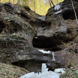
Wonderful opportunity to admire an impressive rock formation and cave and a stunning waterfall from practically every angle, including being able to walk directly behind it! Highly recommend! Short but beautiful hike that does end up going up and down stairs/rocks, so something to keep in mind (not the most accessible). Lovely as a winter hike as well! Sounds like the waterfall is a bit bigger in the winter, and a little drier in the summer. Was very cool to see the ice formations at the bottom when we went as well. Looks like the whole waterfall may have potentially frozen at one point and then melted, leaving the ice at the bottom.

Just a short straight walk from the parking lot, impossible to miss, this cave is an impressive sight. There wasn't any water, we visited after dry summer months, but it was still very impressive. We stayed for probably 30-40 minutes, walked around, imagined how native Indians used this cave as a shelter and for the rituals, hence the name. You can go back the same way, or keep going up the hill and accomplish the full circle returning to the parking lot. There were portable toilets on parking lots on both sides of the road.

Beautiful area, the hike its self was nice. There are some elevated areas and areas that are at a decline. Definitely wear shoes and not sandals. Go the late afternoon we tried around noon and it was just packed and no parking. Nice area to walk and hike trails. Several trails in the area. Maps are at the entrances of the trails.

Sunday April 25th, 2021 went hiking here today with hubby, Tony with my Daughter and son in-law. It was my son in-law first time here. Free to enjoy!! The hike from the parking lot is about a 12 minute walk. Very nice park with awesome scenery. The waterfall is stunning!!! Highly recommend to all that enjoys nature!


While one of the shorter trails in the Hocking Hills area, Ash Cave is absolutely breathtaking and fun to explore. The entrance is super easy as it starts at ground level and really close to the parking lot. Once you make your way down the trail a few hundred yards, you'll quickly notice the tall gorge and cave-like formation. In the center of the cave you find a small trickling waterfall and a teeny little pond where the water lands. Out of the tons of times I've visited, I've never seen this waterfall get any larger than a trickle, but it's beautiful nonetheless. Once you're finished admiring mother nature, the trail leads up a steep set of stairs which will loop you back to the parking lot. Over the years a lot more regulation has been set in place. You used to be able to climb all over the area but with an increase in visitors they're trying to better preserve the space and keep people safe. Pro tip - If you can come early in the morning in the middle of the week, that's ideal. Happy exploring!


This was a tiny, but tall waterfall at the corner of a very wide cave mouth. Being on the sandy base of this trail really gives you perspective at the size of the cliff. This was a quick hike at just .7 miles. The elevation gain was 108 feet and all on the way out - the second half post the cave and falls. The hike in on the one-way trail was a paved sidewalk basically and would be rated easy. The hike out was uphill and moderate. You could do this hike and just go against one-way traffic to get out if you were unable to climb the stairs or hills on the way out.

One of the main popular stops to visit at this amazing park. the cost... Free .. Hocking hills is the best thing Ohio has to offer in my opinion and this is one of the top 5 places to see .. about half mile walk. Its best if you can spend a day or two but if you are like me and make it a day trip .. this is one of the places to put on the list. It's one of the easiest places to hike .. if you back track the way you came it's even easier. Ash cave ..is like many of the caves in Hocking hills ... my husband refers to them as rock shelf but its large and impressive. The falls highest in the area but it's not a strong flow .. I'm betting there are times in late summer it dries up or barely running. It just rained yesterday so is was running great for this late in the year. of course spring would be ideal for viewing the waterfalls. I've seen pics in winter where it's frozen but haven't seen that in person. Hocking hills is different every season .. every time we came.

This trail is shorter compared to other hikes in the park, but it still delivers on the beauty of the natural environment and exploration of the cave. There is a waterfall that seeps over the top of the cave and, combined with the blue sky and nearby trees, made for remarkable memories. I also liked that the path to Ash Cave is handicap- and stroller-accessible.

This was absolutely beautiful and such an amazing place for kids to play! The waterfall was beautiful and even with all the people tourist-ing it was relaxing. I love how accessible this hike was - we took the stroller most of the way and turned around and walked back instead of finishing the loop. The natural beauty was out of this world! read more

The Ash Cave Waterfall is a large natural rock overhang in the Hocking Hills region of Ohio. It is one of the premier Park destinations in the state, and the home of historic native populations in North America for millennia. A remnant of ancient pre-glacial North America, some of the flora species located here are unique to the continent. Other caves are also located nearby, and coupled with a visit to Ash Cave can make a truly unique and memorable visit to Southeast Ohio. Ash Cave is easily accessible from a large nearby parking lot and the trail is handicapped friendly. It is sometimes the location for special events, such as an annual concert by the Columbus Symphony Orchestra. This is a magnificent event and well worth attending, but tickets go fast so if you're interested really be on the lookout for them, so don't delay when they become available. read more


I've been to Hocking Hills twice and both times I've come to do the small hike around Ash Cave Waterfall and I highly recommend everyone make a stop here at least ONCE when they're in the Hocking Hills area! The hike is super easy and reasonable, only about half a mile in total. It's a loop and you get to see so much diversity in landscape and sights throughout the entirety of it! I highly recommend (and I believe it almost is a bit of a "one way" kind of loop that people don't realize, but essentially start on the LEFT path and make your way around the loop clockwise for the best effect! When you begin your hike to the left path, that starts completely paved leading up to the cave and waterfall, so it's very accessible to all to see the waterfall! Once you get to the base of the cave is when the path becomes unpaved, so if you need to you could just turn around from here after drinking in the sights of the cave and return back to the parking lot in an out and back manner. Ash Cave is insanely cool, it's a giant clamshell looking cave cut into the side of the rock with a waterfall that pours down over the rim of the cave so you both get to see it as you approach the cave and even get to walk under and behind the waterfall as you navigate around the cave! It's incredible to see and such a unique one to check out! In the wintertime, the water was falling with even more speed than when we came here in the summer, making for an extra impressive kind of waterfall. The water was cold at the bottom of the base of the waterfall pool as well so there were a bunch of jagged ice pieces in there, making it look like a pool that some sort of crystal mermaid would come out of - absolutely magical! From behind the waterfall, you'll then begin the staircase up the side of the cave as you exit, offering you continued awesome nearly 360 views of the waterfall. You will be walking a few feet and then stopping to take a picture consistently at every point around the falls since the vantage point keeps on changing. It's a very cool experience! Once you get to the top of the stairs, you'll essentially begin your walk back to the parking lot and you'll be in the woods again and won't be able to see the waterfall anymore. From here, it's a consistent and gradual decline back to the parking lot, making the remainder of the hike relatively easy, but watch your step as you'll be navigating unpaved trails and climbing over tree roots and the like. It also ends up being a bit monotonous as well after the beauty of the falls, but before you know it you'll be back at the parking lot! Thoroughly love Ash Cave Waterfall and it's definitely one of the most popular hikes in the Hocking Hills area for good reason! read more


Wonderful opportunity to admire an impressive rock formation and cave and a stunning waterfall from practically every angle, including being able to walk directly behind it! Highly recommend! Short but beautiful hike that does end up going up and down stairs/rocks, so something to keep in mind (not the most accessible). Lovely as a winter hike as well! Sounds like the waterfall is a bit bigger in the winter, and a little drier in the summer. Was very cool to see the ice formations at the bottom when we went as well. Looks like the whole waterfall may have potentially frozen at one point and then melted, leaving the ice at the bottom. read more


6 months ago
7 months ago
Just a short straight walk from the parking lot, impossible to miss, this cave is an impressive sight. There wasn't any water, we visited after dry summer months, but it was still very impressive. We stayed for probably 30-40 minutes, walked around, imagined how native Indians used this cave as a shelter and for the rituals, hence the name. You can go back the same way, or keep going up the hill and accomplish the full circle returning to the parking lot. There were portable toilets on parking lots on both sides of the road. read more


2 months ago
11 months ago
Beautiful area, the hike its self was nice. There are some elevated areas and areas that are at a decline. Definitely wear shoes and not sandals. Go the late afternoon we tried around noon and it was just packed and no parking. Nice area to walk and hike trails. Several trails in the area. Maps are at the entrances of the trails. read more


1 year ago
5 years ago
Sunday April 25th, 2021 went hiking here today with hubby, Tony with my Daughter and son in-law. It was my son in-law first time here. Free to enjoy!! The hike from the parking lot is about a 12 minute walk. Very nice park with awesome scenery. The waterfall is stunning!!! Highly recommend to all that enjoys nature! read more


Nice flat path out to Ash Cave. Ada accessible for wheelchairs and strollers. Cave is huge and there is a spot kids can play in the water too. The second half is more strenuous, but you have the option to go back the way you came from. read more


While one of the shorter trails in the Hocking Hills area, Ash Cave is absolutely breathtaking and fun to explore. The entrance is super easy as it starts at ground level and really close to the parking lot. Once you make your way down the trail a few hundred yards, you'll quickly notice the tall gorge and cave-like formation. In the center of the cave you find a small trickling waterfall and a teeny little pond where the water lands. Out of the tons of times I've visited, I've never seen this waterfall get any larger than a trickle, but it's beautiful nonetheless. Once you're finished admiring mother nature, the trail leads up a steep set of stairs which will loop you back to the parking lot. Over the years a lot more regulation has been set in place. You used to be able to climb all over the area but with an increase in visitors they're trying to better preserve the space and keep people safe. Pro tip - If you can come early in the morning in the middle of the week, that's ideal. Happy exploring! read more


4 years ago
Beautiful, and yes extremely crowded on weekends. This is a really beautiful waterfall which I would recommend visiting super early to avoid the rush. I do believe this location closes earlier than other parks, check hours before going. read more


This was a tiny, but tall waterfall at the corner of a very wide cave mouth. Being on the sandy base of this trail really gives you perspective at the size of the cliff. This was a quick hike at just .7 miles. The elevation gain was 108 feet and all on the way out - the second half post the cave and falls. The hike in on the one-way trail was a paved sidewalk basically and would be rated easy. The hike out was uphill and moderate. You could do this hike and just go against one-way traffic to get out if you were unable to climb the stairs or hills on the way out. read more


One of the main popular stops to visit at this amazing park. the cost... Free .. Hocking hills is the best thing Ohio has to offer in my opinion and this is one of the top 5 places to see .. about half mile walk. Its best if you can spend a day or two but if you are like me and make it a day trip .. this is one of the places to put on the list. It's one of the easiest places to hike .. if you back track the way you came it's even easier. Ash cave ..is like many of the caves in Hocking hills ... my husband refers to them as rock shelf but its large and impressive. The falls highest in the area but it's not a strong flow .. I'm betting there are times in late summer it dries up or barely running. It just rained yesterday so is was running great for this late in the year. of course spring would be ideal for viewing the waterfalls. I've seen pics in winter where it's frozen but haven't seen that in person. Hocking hills is different every season .. every time we came. read more


4 years ago
This trail is shorter compared to other hikes in the park, but it still delivers on the beauty of the natural environment and exploration of the cave. There is a waterfall that seeps over the top of the cave and, combined with the blue sky and nearby trees, made for remarkable memories. I also liked that the path to Ash Cave is handicap- and stroller-accessible. read more


6 years ago
3 years ago
3 years ago
4 years ago
4 years ago
We have visited Ash Cave many times over the years and it always is beautiful no matter the time of the year. This is one of our favorite easy hikes in the Hocking Hills area. We like that the bottom path almost all the way back to the waterfall is paved and quite level. This makes it easily accessible for motorized scooters, wheelchairs and strollers. The park currently still has the one-way trail sign up however if you have mobility restrictions you can go out the same way you came back in. Otherwise the trail leads you up the stairs behind the waterfall and down the side of the hill. That complete hike gives you such a variety of scenery! Tip: when you get to the top of the stairs there's a sign that says it's a 2 mile hike to Cedar Falls. We have actually taken this hike it's 4 miles round-trip and well worth it. But if you're not up for that big of a hike still take a left and walk just a little tiny bit and you'll be able to see the water before it flows over into the waterfall area. read more


More info about Ash Cave Waterfall
26400 State Rt 56
Creola, OH 45622
Directions
Hours
Outdoor Amenities
Ask the Community - Ash Cave Waterfall
Review Highlights - Ash Cave Waterfall


Ash Cave Waterfall - parks - Updated July 2026
Best of Creola
People found Ash Cave Waterfall by searching for…
Fun Things to Do With Kids in Creola, Ohio
Places to Take Pictures in Creola, Ohio
Hiking Trails With Waterfalls in Creola, Ohio
Off Road Trails in Creola, Ohio
Beautiful Views in Creola, Ohio
Running Trails in Creola, Ohio
Walking Trails in Creola, Ohio
Swimming Lakes in Creola, Ohio
Dog Friendly Trails in Creola, Ohio
People who viewed Ash Cave Waterfall also viewed
Rockbridge State Nature Preserve
16 reviews
Clear Creek Metro Park
15 reviews
Hocking Hills State Park
196 reviews
Whispering Cave
1 review
Cross Mound Park
2 reviews
Old Man's Cave Trail
41 reviews
Saltpetre Cave State Nature Preserve
1 review
Chapel Cave
1 review
Lower Falls
2 reviews
Wahkeena Nature Preserve
4 reviews