Cancel

    Open app

    Search

    Amber Ranches

    5.0 (2 reviews)

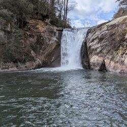
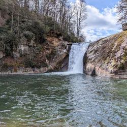
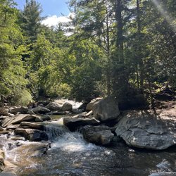
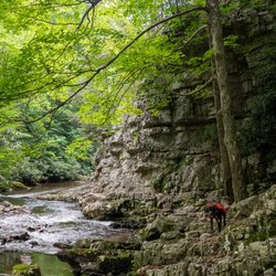
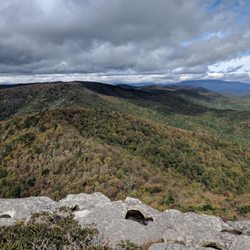
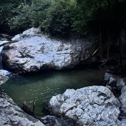
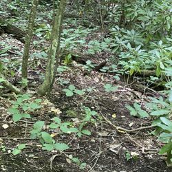
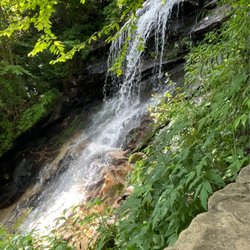
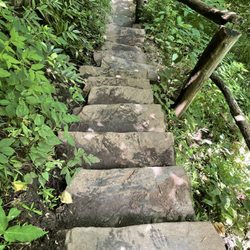
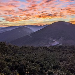
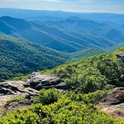
    Amber Ranches Photos

    Recommended Reviews - Amber Ranches

    Your trust is our priority, so businesses can't pay to alter or remove their reviews. Learn more about reviews.
    Yelp app icon
    Browse more easily on the app
    Review Feed Illustration

    6 years ago

    Helpful 0
    Thanks 0
    Love this 0
    Oh no 0

    4 years ago

    We LOVE THIS PLACE called Home. We call it Always And Forever. Southern hospitality can't go wrong.

    Helpful 0
    Thanks 0
    Love this 0
    Oh no 0

    Ask the Community - Amber Ranches

    Verify this business for free

    People searched for Hiking 260 times last month within 15 miles of this business.

    Verify this business

    Upper Creek Falls

    Upper Creek Falls

    5.0(3 reviews)
    20.1 mi

    Loved it!! Beautiful falls and swim hole. I can't wait to be back. Water shoes for when you get…read moredown to the water hole are recommended. It's a nice hike with lots of roots in the way so you need to be careful. But definitely worth it!

    It is my absolute pleasure to introduce UPPER CREEK FALLS to Yelp!…read more If you are a hiker and lover of waterfalls, then you just might want to spend an entire weekend in the Newland, NC area. The mountains surrounding this area are a treasure trove of sights and sound for your soul to behold. Amongst them is the highly popular Upper Creek Falls. Now let me be honest, you're gonna burn some calories on this trail so don't let the short 1.5 miles round trip distance fool you! There is SIGNIFICANT elevation gain that will surely bring a little heavy breathing to your lips and sweat to your brow. However, the payoff is tremendous. **** The creek consists of multiple waterfalls, cascades and swimming holes, but the largest waterfall requires venturing to one of the lowest points on the trail to fully view. It will require detouring off the main yellow blazed trail and mountain-goating it down a steep side trail, then back up to the main trail before continuing the loop back to the parking area. According to ALLTRAILS, the loop starts at an elevation of around 3,215 feet and drops as low as 2,790 feet for a gain of approx. 425 feet in 3/4's of a mile. My personal trail tracker logged 436 feet of gain. The lowest point of the trail leads to a wonderfully exposed area of stone that almost acts as a raceway for the creek. The topography is such that you can walk on an island of stone that splits the creek in two for a short distant before rejoining and continuing its descent. I can only imagine how many more waterfalls are below this point as the creek continues its slide down the mountain another 460 feet over the following mile according to topography maps. *** FEATURES 1) There are two trailheads, but each links to the other. The trailhead on the left side of the parking area behind the information board leads first to the top of the main waterfall before crossing the creek and descending towards the base. You can get some terrifying pics on the dry stone near the crest, but don't drift too close to the edge! 2) Once you cross the creek, look to the left to spot a faint trail leading back up the mountain. Follow it and you will be rewarded with a gorgeous 15 foot waterfall. Here locals us the fall as a slide, complete with a rope to help you get back up to the top of this ultra-smooth cascade. 3) There is a fairly deep pool of water here and opposite of the climbing rope is a tire swing to launch into the pool. 4) Continue down the trail until you see side trails leading to the base of the largest waterfall. WARNING: The side trail is steep, but worth it to view the larger fall in its entirety. 5) As you continue down the trail it will once again cross the creek. This crossing is most likely tricky in high water and probably not advisable. It was only at average flow when I visited and I still got my feet wet doing my best jump. It is here you will discover another small pool of water and a large area to camp out on the stone outcrop. Even though this is the lowest point on the trail, it is actually an overlook of the mountains below. Very open and majestic. 6) Once across the lowest creek crossing, the trail switchbacks up the mountain OR you can find the shortcut trail that goes straight up the center! But fair warning, it's a leg burner! This portion of the loop will return to the parking lot on the opposite side of the upper creek trail. In total I logged 1.5 miles after visiting the sliding falls, main falls and lower raceway/overlook. *** FINAL THOUGHTS Upper Creek Falls in my opinion is 5+ stars despite its difficulty because of the multiple points of interest along the loop. I HIGHLY RECOMMEND this waterfall to avid hikers! While I personally would have thought it to be too much for kids and elderly... we saw SEVERAL older couples in the area above the main falls as well as a school bus load of 6 to 12-year-olds trekking along the lower falls trail well ahead of their parents. There was also a very large family of about 20 members (all age ranges) picnicking at the lower overlook, so I guess its safe to say its doable for all ages and skill levels. If you have any energy left, to the northeast are: - Grandfather Mountain - Big Lost Cove Cliffs - Harper Creek Falls - Gragg Prong Falls - Huntfish Falls And to the southwest are: - Linville Falls & Linville Caverns ENJOY! 2021 / 116

    Photos
    Upper Creek Falls
    Upper Creek Falls
    Upper Creek Falls

    See all

    Hawksbill Mountain

    Hawksbill Mountain

    5.0(3 reviews)
    20.9 mi

    We were looking for a place to go hiking where we could see good fall colors. We found a guide that…read moresaid this would be the perfect elevation for the weekend we wanted to go. There isn't much parking, maybe 5-10 spots, but tons of cars park along the road. The last few miles to get there is a bumpy gravel road. I had read that it was a 1.5 mile round trip hike, but it ended up being around 2.3 miles. It was a pretty short hike to the summit, but it was a decent climb. It's not marked all that well. At the first split, take a left. There is a sign that points you back to the parking lot which you can use in reverse to figure out which way the summit must be. There's another split close to the top. We were told that both ways will take you to the summit with the left being shorter and steeper. The views at the summit are breathtaking. You can get a view from the left side, but the actual summit is to the right. You can get 360 degree views that are stunning. It was incredibly windy at the summit. The hike up wasn't because of the trees blocking it, but it felt like you might get blown off the summit. We were a little disappointed because the views were still almost completely green, but leaves changing is probably happening a lot later than normal this year because of the warm weather. You can also drive a couple of miles down the road and hike to the Table Rock summit. We decided to call it a day after Hawksbill, but might come back another time. If you're looking for a short hike with awesome views, I would highly recommend this one!

    What a gem this mountain is. The summit is gorgeous and plateaus in a really unique way. The view…read moreat sunset is breathtaking and there are a few areas to set up and camp. Not a lot of parking at the bottom on the dirt road so be prepared to park by the roadside.

    Photos
    Hawksbill Mountain - Hawksbill

    Hawksbill

    Hawksbill Mountain
    Hawksbill Mountain

    See all

    Douglas Falls

    Douglas Falls

    4.3(3 reviews)
    27.1 mi

    This hike is NOT for the inexperienced. The hike itself deserves the highest rating- ONLY FOR those…read morewho are into high intensity, steep, rocky terrains. I'd suggest this for someone who enjoys camping between the return hike or is very experienced in outdoor endeavors. The falls are beautiful, although not in my opinion worth the 7.6 miles of uphill battle. There is a separate way to get here (0.5 hike from it's own parking lot) The trail connects to a beautiful "Greyson's Overlook" for an additional 2.2 miles. Overall- I made it and I'm still alive.

    We had so many options to choose from when hiking yesterday that we just decided to pick one. How…read moredid we miss that this was rated hard?! I'm going to give you my most honest review possible because I think we did not have a clear vision of what to expect. Based off of other people's shoe choices at the top, I decided to wear my tennis shoes. Big mistake. My husband wore his hiking boots. Definitely ate crow on my choice of footwear. Wear hiking boots! The trail was overgrown much of the way. There were a few little rocky river areas to cross over. I managed those with the help of my husband. But my shoes were not appropriate for all of the rocky, muddy, slick areas. And there were many! There were a few trees to go over that had fallen into the pathway. I am a short girl, 5'1", and getting over them on the steep, slick trail was a feat! Also needed my husbands help for that. The trail was very overgrown in some areas, to the point that we weren't sure if we should continue, but we pressed on. There was some uphill in the beginning that had us begging for a little downhill relief. We got that... for awhile. Then, we paid the price for it on the way back. A whole lot of uphill on the way back! My knees, legs, and back were killing me on the way back and I definitely thought about bringing a child back pack to ride on my husbands back for our next hike. We aren't out of shape or inactive people. We enjoy hiking and try to do it often. We have a peloton at home that we do actually use. But this trail was 100% hard and more than we bargained for. I guess we figured that we made it on an accidental 9.5 mile hike the last time we were in town and would be fine. Wrong! Yeah, I'm old. 38. And my husband is 35. We aren't old old but we aren't 18 anymore either. (Thank goodness--that would make him 15! And no thanks to that.) At one point on the hike, we asked a couple that passed us if we were almost at the falls. They said about 15 minutes. I would guess it took us probably another hour to hour and a half to get there. We had to be very careful with my tennis shoes and the slippery rocky trail. Plus, climbing over the downed trees. I'm hoping maybe they were just high and time was confusing for them. I don't see any way they could've gone the mile and a quarter in 15 minutes. Regardless... we made it. The fall was beautiful. The hike kicked our asses. I would not do this hike again. Ever. But if you're down for a difficult, rocky, overgrown, steep hike.... Have at it! I will 100% stay out of your way. The waterfall was a nice treat. Be prepared to pray for the existence of an Uber Air to get back up. (Except those of you who are clearly far more trail savvy than us. I'm sure you will find it much easier than we did. And also... kudos to you!) Apx 7.8 miles of pure torture. Done and done!

    Photos
    Douglas Falls
    Douglas Falls - Douglas falls

    Douglas falls

    Douglas Falls

    See all

    Amber Ranches - hiking - Updated May 2026

    Loading...
    Loading...
    Loading...