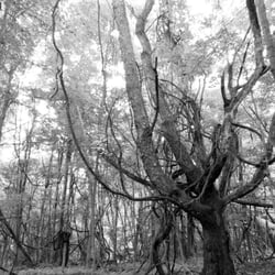
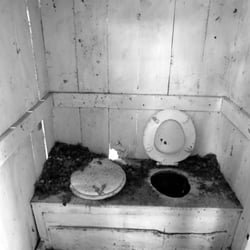
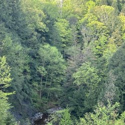
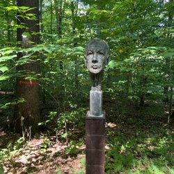
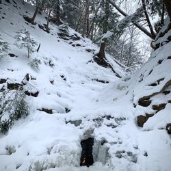
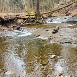
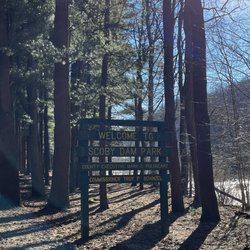
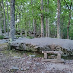
Zoar Valley Photos


More like Zoar Valley
Recommended Reviews - Zoar Valley
Start your review...

Reviews With Photos

Beautiful park for a nice hike with the family. The trails are marked but they can be a little dangerous if you aren't paying attention so please....pay attention! There are beautiful rock formations and the trees and landscape is exceptionally beautiful during the fall. There are several sections of the park that you can park and hike so do your research before deciding which parking area to use to get to the destination you are looking for. And find yourself a good hiking stick!

Gonna start this review with a shout-out to my right hand man, Javert, for keeping me balanced all afternoon. Okay, so right hand walking stick, because I give inanimate objects names when I know I shouldn't. Honestly, my props should go to Laney H for her review helped lay a course that didn't make me think I was going to die falling off some high height. He mentioned he had brought his kids, and I tend to have the balance of one, so it met my needs. My mate slept in, so we arrived a bit later than hoped, which meant a few others were out, though they took different directions, one opting to stay and sunbathe along the water. I was serenading my mate when a couple spotted us (read: suffered ear torture from my direction) and said hello. He advised us to keep walking to reach a waterfall. We had passed a few tiny ones (pretending to be water droplets, shouting wheee into the solitude) and would have gone further, but they hadn't a toilet, and when you're staying hydrated, the tinkle tank tends to get a bit full. There's a sign at the entrance about picking up your trash. DMML was there, or so says his graffiti. Some people apparently couldn't read, or did and chose to ignore the sign. Along the way, we discovered a gaggle a beer bottles guarding an empty container of pineapple weed. As for the other sort of weeds, it was also absent, a very pure land. Once you get past the discarded underwear abandoned on the rocks that is. I wouldn't suggest going skinny dipping, as there are rocks aplenty, and teensy weensy tadpoles about. The water was about calf high, and as we waded through, my stick testing the depths, we came across many animal friends. We found two frogs, who must've been responsible for all the spawns, picking one up for a photoshoot. There was a crawfish, and I got him to crawl up onto my stick to say hello before parting ways. And there was a duck, amongst probably half a dozen other creatures beyond our grasp. We came across a rock path across the water. It's gorgeous, and sure, take a picture, but I wobbled and aborted mission before plunging sideways into the water. Word to the wise, waterproof everything. Your shoes and phone, mayhaps your butt. Mine got covered in dirt as I scooted down a hill after deciding not to follow the wooded path back to the car. It was lovely, but headed uphill, and my thighs are not ready for that kind of beautiful torture. One negative I'll note is that the driveway to get to the parking area, it's a two way, but if your car has love handles, exercise caution. It's a tight squeeze. That being said, worth the drive out, and worth the extra buck you'll spend on sunscreen and bug spray to avoid the negative consequences of a day in paradise.

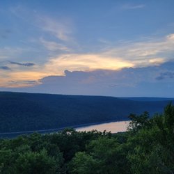
Large valley, with a lot of area to hike around. There are five parking lots (see the map https://www.yelp.com/biz_photos/zoar-valley-cattaraugus?select=kzx0dkZm6QQ5BqPgK0A4rQ&reviewid=1CIc_xbuv_OG5stQmxdFdA) but I recommend the one furthest south at the base of the creek (Forty Road Parking Area 10229 Forty Rd, Gowanda, NY 14070). This isnt an easy trek, mainly due to the fact that you have to wade through the creek if you want to get anywhere. I highly recommend a walking stick for this to help give stability in the rapids, and there are going to be times of the year where the current is just too strong to cross, so plan your trip accordingly. There are a few trails within the woods you can follow, but nothing super well maintained, and we also had the misfortune of stepping on a wasps nest on the ground, so watch out for those too. There is very little or any cell service in the canyon, so always go with a buddy. The cliffs are pretty unstable, so I dont recommend walking alongside them, or at the top of them - people have died when they have lost their footing. I believe the other parking lots give you more access to the top of the cliffs, but I have only ever hiked the valley floor. I know I am making this sound like a death trap, but it really is a fabulous hike when the weather and creek conditions are favorable. Just remember to respect the potential dangers. And a first aid kit is always a good thing to have.


My absolute fave hiking trail. Zoar Valley is a 1,400+ preserved lands which includes old forests growths, waterfalls, a beautiful valley and river to explore. This Fall my friend and I completed the Valentine Flat Road Trail. We picked the perfect fall day for our hike. The fall colors were lovely and made for great photos. Hiking guides marks this trail as easy but I would say that there are a few portions that I would consider moderate. There is one steep path that you need to tackle on your way back which is doable. The portion of the trail that could be challenging for some hikers is maneuvering through the muddy portions of the trail. You will need to watch your footing and be careful to select the safest path as you attempt to proceed through the trail so, make sure you have your hiking boots with you. Finally, I want to mention that there are portions of the trail that brings you to the highest points of the gorge (380 feet). Be careful not to get too close to the edge as there have been people who have fallen and died. But, don't let this stop you from exploring bc hiking near the edge is a choice not a requirement. You can hike the trails safely several feet from the edge of the cliffs. Cellular reception is weak in this area, but if you are using a fitness App or All Trails App the GBS will work. I highly recommend using a GBS on your hikes as you can always rely on it to help you on your way back just In case you hike off the trail or miss a marker. I have been to Zoar Valley many times and never get bored. Once you experience Valentine Flat you will need to come back and explore Forty Road and Deer Lick Trails for a different experience. Ps. I have heard but never witnessed first hand that on occasion you could run across some nudist while hiking up the river at Forty Road. I wanted to give everyone the heads up in case you it happens to be your lucky day!

Can't wait to come back. I am thinking of playing hookie from work and coming on a beautiful sunny Tuesday. There is great hiking and swimming holes. From the parking are if u take the south trail on the adage by the edge of the creek you can find a lot of great swimming spots. On the north trail you can find some great looking waterfalls.

This place is gigantic, and gorgeous. We parked at the 40 point parking (free) and made our way into the trees. Immediately saw a small waterfall (I believe there are 40+) and then made our way down to the valley. We spent a good hour and a half walking through the valley part and did not even get to really hike, so we will have to return to hike the top. The valley itself was awesome. I was not sure what to expect so I wore running shoes, and as soon as we got into the valley part I had to switch back into my flip flops. We had to cross cross across the duration of the valley by stepping on rocks and walking through the water. It was a hot day so I didn't mind the cool water at all! Flip flops are in the garbage now but totally worth it. Be careful when you are standing near the walls of the valley, we almost got hit by falling debris off the top of the edge! We literally moved 10 seconds before a giant piece fell down right where we were standing! If you plan to come here - bring the right shoe(s), water, snacks and towels! We saw many people picnicking / with their dogs / settled in one spot. Good views for lunch and a walk for sure. Excited to go back and hike.

Creek hiking Great for kids & families if you hike in the creek and NOT down the gorge! Start at the bottom and stay at the bottom. Incredibly safe and really fun! Follow my directions below and it's great for families and kids. We went to the forty road access point parking lot and hiked through the creek down stream and loved it! We took 3 small children (ages 8,6,3) and it was fabulous. We played in the water, hiked around, built rock cairns and explored. Definitely wear durable water shoes or tennis shoes that you'll get wet in. I recommend a swimming suit or "get wet in" clothes (especially for little kids) so you can just enjoy the water and hike and not worry about getting too wet. It's not very dangerous but it is slippery and rocky so there will most likely be a few slips and falls. We followed the directions someone here on Yelp posted and we found it easily. I'll add those directions in a picture.


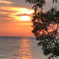
As a girl who grew up hiking the canyons and mountains of the wild Southwest, I feel almost at home in the depths of Zoar Valley, a beautiful shale canyon with turquoise-blue waters and long stretches of inviting sand, perfect for picnics and sunbathing. You'd never know this hidden gem was less than an hour's drive from postindustrial Buffalo (which has its own kind of beauty, but c'mon. A girl's gotta see some real trees sometimes!) Once we found our way here*, we enjoyed a beautiful, leisurely stroll up the creek. It's so shallow and calm that we did, quite literally, hike in the creek quite a bit. After enjoying lunch on a sunny stretch of beach, we headed back, only to run into a few solemn-looking wildnerness workers who informed us that hiking upstream has now been banned, due to some purportedly dangerous waterfalls and such. We talked our way out of a ticket (apparently, trespassing upstream can cost you a couple hundred bucks), and made a note to hike only downstream from Forty Road. I also made a note to bring my Tevas next time for hiking in the cool water, and my dog! (We saw other hikers with their pups, and I know my best canine bud LOVES a good romp in the water.) Pro tip: after your hike, be sure to hit up Scoops in Gowanda. SO MANY FLAVORS of ice cream, and the folks on staff are pretty sweet, too. http://www.yelp.com/biz/scoops-gowanda As Hamburg's also on the way home, you can grab a lunch before you go, or a dinner afterwards. All in all, one of the best daytrips out of Buffalo I've taken so far! *The Audubon Society kindly provided us with the following instructions on finding the parking lot, which was still a bit tough (not their fault). Here are the instructions verbatim, for my fellow explorers' reference: "From the Buffalo area, take Rt. 62 south to Gowanda. From Ontario or Rochester, the NY Thruway takes you to Rt. 62 from Exit 58 at Hamburg. From points south of Gowanda, Rt. 17 will take you to Rt. 62 north or Rt. 353 north, both of which take you to Gowanda.Once in downtown Gowanda, where Rt. 62 crosses Cattaraugus Creek, turn east onto Water St., which parallels the creek along its south bank. As you follow it, the same street will change names before becoming labeled Broadway where it veers right. It will suddenly ascend a steep hill. Just at the top of the hill, watch carefully for Point Peter Rd. on your left! Take scenic Point Peter Rd. for 1.8 miles until you reach Forty Rd. Turn left on Forty Rd and drive to its end. This includes driving down a very steep but well-constructed paved road. In good weather, regular cars have no problem on this road. It takes you to the bottom of South Branch Cattaraugus Creek, where there is a parking area. (Caution: never drive down this road when there is ice or snow on it, or with a car that is in poor condition. It may be impossible to get back up.)"

Just an hour outside of Buffalo, this gorgeous conservation area has everything that you need in a hike. A steam running through a massive valley, untouched paths formed entirely by nature, and tall peaks overlooking the entire park. I couldn't tell you anything about the path we took b/c there are no signs and you better go w/ someone who knows where they're going. Also, the waterfall is apparently on private property and off-limits to visitors but seems like ppl frequently sneak over there as long as security doesn't catch you. We were not so fortunate but the rest of the park was still worth the trip.
")
2 years ago
We Did the blue, red and yellow trails around the ponds off of Vail rd . Before that we started down the Cattauragus creek trail on other side of gorge but we decided we were not up for THAT challenge this time w/ 300 ft decend and climb. Fall colors were perfect and temp in 60s was great. Area is Somewhat developed but trails are rough and narrow in many places. read more


9 months ago
5 years ago
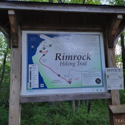
Great hiking trails so close to the city of Buffalo. We ventured out one of the weekends for a bit of nature time. We went out on multiple hikes and each of them was uniquely rewarding. The first trail that we did was called Holcomb pond trail. The hike was about 2 miles one way and was moderate with a few drops and inclines but it takes you through a bunch of pretty ponds on the way. The trail is not very well marked though so you might get lost on the way if you are not paying attention. There are colored marks on the trees to guide you. The second trail that we did was Deer luck conservation area which was a 3.2 mile round trip with great views of the river gorge and was an easy hike for us. This is the better one to start with if you are a beginner hiker. This trail was better marked too than the other one and was easy to follow. But watch out for snakes because even though we didn't see any (I was hoping not to), we passed a lot of people who mentioned seeing some on the trails. Zoar valley is huge and we didn't even go on the most popular trail 'the Valentine's flats' so I'm definitely making a trip back to cover that. read more


Beautiful park for a nice hike with the family. The trails are marked but they can be a little dangerous if you aren't paying attention so please....pay attention! There are beautiful rock formations and the trees and landscape is exceptionally beautiful during the fall. There are several sections of the park that you can park and hike so do your research before deciding which parking area to use to get to the destination you are looking for. And find yourself a good hiking stick! read more


6 years ago
Gonna start this review with a shout-out to my right hand man, Javert, for keeping me balanced all afternoon. Okay, so right hand walking stick, because I give inanimate objects names when I know I shouldn't. Honestly, my props should go to Laney H for her review helped lay a course that didn't make me think I was going to die falling off some high height. He mentioned he had brought his kids, and I tend to have the balance of one, so it met my needs. My mate slept in, so we arrived a bit later than hoped, which meant a few others were out, though they took different directions, one opting to stay and sunbathe along the water. I was serenading my mate when a couple spotted us (read: suffered ear torture from my direction) and said hello. He advised us to keep walking to reach a waterfall. We had passed a few tiny ones (pretending to be water droplets, shouting wheee into the solitude) and would have gone further, but they hadn't a toilet, and when you're staying hydrated, the tinkle tank tends to get a bit full. There's a sign at the entrance about picking up your trash. DMML was there, or so says his graffiti. Some people apparently couldn't read, or did and chose to ignore the sign. Along the way, we discovered a gaggle a beer bottles guarding an empty container of pineapple weed. As for the other sort of weeds, it was also absent, a very pure land. Once you get past the discarded underwear abandoned on the rocks that is. I wouldn't suggest going skinny dipping, as there are rocks aplenty, and teensy weensy tadpoles about. The water was about calf high, and as we waded through, my stick testing the depths, we came across many animal friends. We found two frogs, who must've been responsible for all the spawns, picking one up for a photoshoot. There was a crawfish, and I got him to crawl up onto my stick to say hello before parting ways. And there was a duck, amongst probably half a dozen other creatures beyond our grasp. We came across a rock path across the water. It's gorgeous, and sure, take a picture, but I wobbled and aborted mission before plunging sideways into the water. Word to the wise, waterproof everything. Your shoes and phone, mayhaps your butt. Mine got covered in dirt as I scooted down a hill after deciding not to follow the wooded path back to the car. It was lovely, but headed uphill, and my thighs are not ready for that kind of beautiful torture. One negative I'll note is that the driveway to get to the parking area, it's a two way, but if your car has love handles, exercise caution. It's a tight squeeze. That being said, worth the drive out, and worth the extra buck you'll spend on sunscreen and bug spray to avoid the negative consequences of a day in paradise. read more


Large valley, with a lot of area to hike around. There are five parking lots (see the map https://www.yelp.com/biz_photos/zoar-valley-cattaraugus?select=kzx0dkZm6QQ5BqPgK0A4rQ&reviewid=1CIc_xbuv_OG5stQmxdFdA) but I recommend the one furthest south at the base of the creek (Forty Road Parking Area 10229 Forty Rd, Gowanda, NY 14070). This isnt an easy trek, mainly due to the fact that you have to wade through the creek if you want to get anywhere. I highly recommend a walking stick for this to help give stability in the rapids, and there are going to be times of the year where the current is just too strong to cross, so plan your trip accordingly. There are a few trails within the woods you can follow, but nothing super well maintained, and we also had the misfortune of stepping on a wasps nest on the ground, so watch out for those too. There is very little or any cell service in the canyon, so always go with a buddy. The cliffs are pretty unstable, so I dont recommend walking alongside them, or at the top of them - people have died when they have lost their footing. I believe the other parking lots give you more access to the top of the cliffs, but I have only ever hiked the valley floor. I know I am making this sound like a death trap, but it really is a fabulous hike when the weather and creek conditions are favorable. Just remember to respect the potential dangers. And a first aid kit is always a good thing to have. read more


This was a really cool place to check out with the kids. Spent time walking, wading, and skipping stones off the Forty Street entrance. Went during the week and there was hardly anyone there. Would definitely visit again if back in the area! read more


3 years ago
My absolute fave hiking trail. Zoar Valley is a 1,400+ preserved lands which includes old forests growths, waterfalls, a beautiful valley and river to explore. This Fall my friend and I completed the Valentine Flat Road Trail. We picked the perfect fall day for our hike. The fall colors were lovely and made for great photos. Hiking guides marks this trail as easy but I would say that there are a few portions that I would consider moderate. There is one steep path that you need to tackle on your way back which is doable. The portion of the trail that could be challenging for some hikers is maneuvering through the muddy portions of the trail. You will need to watch your footing and be careful to select the safest path as you attempt to proceed through the trail so, make sure you have your hiking boots with you. Finally, I want to mention that there are portions of the trail that brings you to the highest points of the gorge (380 feet). Be careful not to get too close to the edge as there have been people who have fallen and died. But, don't let this stop you from exploring bc hiking near the edge is a choice not a requirement. You can hike the trails safely several feet from the edge of the cliffs. Cellular reception is weak in this area, but if you are using a fitness App or All Trails App the GBS will work. I highly recommend using a GBS on your hikes as you can always rely on it to help you on your way back just In case you hike off the trail or miss a marker. I have been to Zoar Valley many times and never get bored. Once you experience Valentine Flat you will need to come back and explore Forty Road and Deer Lick Trails for a different experience. Ps. I have heard but never witnessed first hand that on occasion you could run across some nudist while hiking up the river at Forty Road. I wanted to give everyone the heads up in case you it happens to be your lucky day! read more


10 years ago
Can't wait to come back. I am thinking of playing hookie from work and coming on a beautiful sunny Tuesday. There is great hiking and swimming holes. From the parking are if u take the south trail on the adage by the edge of the creek you can find a lot of great swimming spots. On the north trail you can find some great looking waterfalls. read more


This place is gigantic, and gorgeous. We parked at the 40 point parking (free) and made our way into the trees. Immediately saw a small waterfall (I believe there are 40+) and then made our way down to the valley. We spent a good hour and a half walking through the valley part and did not even get to really hike, so we will have to return to hike the top. The valley itself was awesome. I was not sure what to expect so I wore running shoes, and as soon as we got into the valley part I had to switch back into my flip flops. We had to cross cross across the duration of the valley by stepping on rocks and walking through the water. It was a hot day so I didn't mind the cool water at all! Flip flops are in the garbage now but totally worth it. Be careful when you are standing near the walls of the valley, we almost got hit by falling debris off the top of the edge! We literally moved 10 seconds before a giant piece fell down right where we were standing! If you plan to come here - bring the right shoe(s), water, snacks and towels! We saw many people picnicking / with their dogs / settled in one spot. Good views for lunch and a walk for sure. Excited to go back and hike. read more


3 years ago
Creek hiking Great for kids & families if you hike in the creek and NOT down the gorge! Start at the bottom and stay at the bottom. Incredibly safe and really fun! Follow my directions below and it's great for families and kids. We went to the forty road access point parking lot and hiked through the creek down stream and loved it! We took 3 small children (ages 8,6,3) and it was fabulous. We played in the water, hiked around, built rock cairns and explored. Definitely wear durable water shoes or tennis shoes that you'll get wet in. I recommend a swimming suit or "get wet in" clothes (especially for little kids) so you can just enjoy the water and hike and not worry about getting too wet. It's not very dangerous but it is slippery and rocky so there will most likely be a few slips and falls. We followed the directions someone here on Yelp posted and we found it easily. I'll add those directions in a picture. read more


As a girl who grew up hiking the canyons and mountains of the wild Southwest, I feel almost at home in the depths of Zoar Valley, a beautiful shale canyon with turquoise-blue waters and long stretches of inviting sand, perfect for picnics and sunbathing. You'd never know this hidden gem was less than an hour's drive from postindustrial Buffalo (which has its own kind of beauty, but c'mon. A girl's gotta see some real trees sometimes!) Once we found our way here*, we enjoyed a beautiful, leisurely stroll up the creek. It's so shallow and calm that we did, quite literally, hike in the creek quite a bit. After enjoying lunch on a sunny stretch of beach, we headed back, only to run into a few solemn-looking wildnerness workers who informed us that hiking upstream has now been banned, due to some purportedly dangerous waterfalls and such. We talked our way out of a ticket (apparently, trespassing upstream can cost you a couple hundred bucks), and made a note to hike only downstream from Forty Road. I also made a note to bring my Tevas next time for hiking in the cool water, and my dog! (We saw other hikers with their pups, and I know my best canine bud LOVES a good romp in the water.) Pro tip: after your hike, be sure to hit up Scoops in Gowanda. SO MANY FLAVORS of ice cream, and the folks on staff are pretty sweet, too. http://www.yelp.com/biz/scoops-gowanda As Hamburg's also on the way home, you can grab a lunch before you go, or a dinner afterwards. All in all, one of the best daytrips out of Buffalo I've taken so far! *The Audubon Society kindly provided us with the following instructions on finding the parking lot, which was still a bit tough (not their fault). Here are the instructions verbatim, for my fellow explorers' reference: "From the Buffalo area, take Rt. 62 south to Gowanda. From Ontario or Rochester, the NY Thruway takes you to Rt. 62 from Exit 58 at Hamburg. From points south of Gowanda, Rt. 17 will take you to Rt. 62 north or Rt. 353 north, both of which take you to Gowanda.Once in downtown Gowanda, where Rt. 62 crosses Cattaraugus Creek, turn east onto Water St., which parallels the creek along its south bank. As you follow it, the same street will change names before becoming labeled Broadway where it veers right. It will suddenly ascend a steep hill. Just at the top of the hill, watch carefully for Point Peter Rd. on your left! Take scenic Point Peter Rd. for 1.8 miles until you reach Forty Rd. Turn left on Forty Rd and drive to its end. This includes driving down a very steep but well-constructed paved road. In good weather, regular cars have no problem on this road. It takes you to the bottom of South Branch Cattaraugus Creek, where there is a parking area. (Caution: never drive down this road when there is ice or snow on it, or with a car that is in poor condition. It may be impossible to get back up.)" read more

14 years ago
Just an hour outside of Buffalo, this gorgeous conservation area has everything that you need in a hike. A steam running through a massive valley, untouched paths formed entirely by nature, and tall peaks overlooking the entire park. I couldn't tell you anything about the path we took b/c there are no signs and you better go w/ someone who knows where they're going. Also, the waterfall is apparently on private property and off-limits to visitors but seems like ppl frequently sneak over there as long as security doesn't catch you. We were not so fortunate but the rest of the park was still worth the trip. read more


For my hubby's 32nd birthday I decided to take him on a series of free adventures. I planned an entire week of activities that were either free or cheap...each day started off with me telling him what to wear, and what to bring with him for the day. This was one of the most memorable birthdays we've shared over our 14 years together :) Among the activities for the week were WALKING through customs over the Canadian bridge, Tuesday morning bowling, a trip to the SPCA, lounging on the beach at Woody's, and renting a cabin near Zoar and hiking the valley the following morning. I was really sad we had missed the Yelp outing to Zoar Valley, so after reading all the great reviews I decided to take matters into my own hands and figure out how to get there. The directions we had to get to the actual entry point were not very clear, so it took us a while of driving up and down back roads to finally find the right spot. We even had to stop and chat with a nice elderly couple who were relaxing on their porch with their hound dog. They pointed us in the general direction, and trial and error got us the rest of the way. When we entered the actual valley, all the reviews said we were to make a left instead of a right because rangers on horses will give you a ticket for trespassing. We didn't listen. It was a weekday morning, so we figured we could take our chances. There were reports of a magical waterfall upstream, as well...and that's what we were in hot pursuit of. We walked, and walked, and walked, and walked...and finally, just as we were about to give up, we came across the waterfall! There were a few other people that we passed on our way, and also a few people chilling just above the waterfall. But for the most part, we were left to ourselves. We came appropriately dressed in bathing suits, so we took a lil swim under the falls. I swear I felt little things eating my toes, so my swim was short lived...but the hubby played under the falls for a few mins, just long enough for me to snap a couple pics to prove we had arrived at our destination. Since our trip, I've seen several friends post on facebook about hiking Zoar Valley. One of them even posted about not being able to find the falls, and that they were going back again to track it down. It took all I could to not give them directions and advice...because I think part of the beauty of the spot is the goose chase leading up to it. :) read more
 - Parks Near Me")


8 years ago
10 years ago
10 years ago
9 years ago
11 years ago
More info about Zoar Valley
Ask the Community - Zoar Valley
Review Highlights - Zoar Valley


Why does Yelp recommend reviews?
1 review that is not currently recommended
The reviews below are not factored into the business's overall star rating.
11 years ago
Zoar Valley - parks - Updated June 2026
Best of Cattaraugus
People found Zoar Valley by searching for…
Things to Do in Cattaraugus, New York
Beaches in Cattaraugus, New York
Fishing in Cattaraugus, New York
Hiking Trails With Waterfalls in Cattaraugus, New York
Playgrounds in Cattaraugus, New York
Fun Things to Do With Kids in Cattaraugus, New York
Photo Spots in Cattaraugus, New York
Scenic Overlook in Cattaraugus, New York
Fishing Spots in Cattaraugus, New York
Places to Take Pictures in Cattaraugus, New York
Walking Trails in Cattaraugus, New York
Off Road Trails in Cattaraugus, New York
Day Trips in Cattaraugus, New York
Secret Spots in Cattaraugus, New York
River Swimming in Cattaraugus, New York
Tennis in Cattaraugus, New York
Attractions in Cattaraugus, New York
Waterfalls in Cattaraugus, New York
Scenic Views in Cattaraugus, New York
Beautiful Views in Cattaraugus, New York
Watch Sunset in Cattaraugus, New York
Swimming Holes in Cattaraugus, New York
Trending Searches in Cattaraugus, NY
Cliff Jumping near Zoar Valley
Dog Friendly Beaches near Zoar Valley
Fishing Spots near Zoar Valley
Lakes & Ponds near Zoar Valley
Off Road Trails near Zoar Valley
Places To Swim near Zoar Valley
Pool Supplies near Zoar Valley
Public Shower near Zoar Valley
Running Trails near Zoar Valley
Strawberry Picking near Zoar Valley
Swimming Holes near Zoar Valley
Browse Articles
Browse Nearby
Browse Brands
Related Searches in Cattaraugus, NY
Best Nature Trails for Hiking in Cattaraugus, New York
Best Off Leash Dog Parks in Cattaraugus, New York
Best Parks for Parties and Events in Cattaraugus, New York
Best Spots for Star Gazing in Cattaraugus, New York
Best Water Parks for Kids in Cattaraugus, New York
Best Waterfalls and Swimming Holes in Cattaraugus, New York
Check Out Great Playgrounds in Cattaraugus, New York
Check Out Off Road Trails in Cattaraugus, New York
Discover Baseball Fields Around Cattaraugus, New York
Discover Dog Friendly Beaches Near Cattaraugus, New York
Discover Dog Friendly Trails to Explore in Cattaraugus, New York
Discover Fun Toddler Parks in Cattaraugus, New York for Your Little One
Discover Lakes & Ponds to Explore in Cattaraugus, New York
Discover Popular Bike Trails in Cattaraugus, New York
Discover Popular Photo Spots in Cattaraugus, New York
Discover Soccer Fields in Cattaraugus, New York Near You
Discover Top Nature Parks to Visit in Cattaraugus, New York
Discover a Hiking Trail in Cattaraugus, New York
Discover the Best Night Hike Trails in Cattaraugus, New York
Discover the Best Running Track in Cattaraugus, New York
Dog-Friendly Hikes With Dogs in Cattaraugus, New York
Effective Stairs Workout Spots in Cattaraugus, New York
Enjoy Scenic Night View Experiences in Cattaraugus, New York
Enjoy the Best Night View Spots in Cattaraugus, New York
Enjoy the Best Picnic Spots and Ideas in Cattaraugus, New York
Enjoy the Best Walking Trails in Cattaraugus, New York
Exciting Cliff Jumping Spots in Cattaraugus, New York
Experience Stunning Sunset Views in Cattaraugus, New York
Explore Beautiful Parks and Green Spaces in Cattaraugus, New York
Explore Easy Hikes Perfect for All in Cattaraugus, New York
Explore Free Picnic Areas Around Cattaraugus, New York
Explore Off Leash Dog Beaches in Cattaraugus, New York
Explore Popular Picnic Areas Around Cattaraugus, New York
Explore Popular Scenic Overlook Points in Cattaraugus, New York
Explore Popular Scenic Views Near Cattaraugus, New York
Explore Popular View Points Around Cattaraugus, New York
Explore Secret Spots Worth Visiting in Cattaraugus, New York
Explore Top Dog Parks in Cattaraugus, New York Near You
Explore the Best Swimming Holes Around Cattaraugus, New York
Family Friendly Hiking With Kids in Cattaraugus, New York
Find Beautiful Views in Cattaraugus, New York
Find Fun Kids Activities Outdoor in Cattaraugus, New York
Find Parks and Recreation Activities in Cattaraugus, New York
Find Picnic Tables for Outdoor Fun in Cattaraugus, New York
Find Top Dog Friendly Parks to Visit in Cattaraugus, New York
Find Top Dog Swimming Spots in Cattaraugus, New York
Find Top-Rated Waterfalls in Cattaraugus, New York Now
Find a Public Running Track in Cattaraugus, New York
People who viewed Zoar Valley also viewed
Lake Erie State Park
14 reviews
Point Gratiot Park
2 reviews
Allegany State Park
3 reviews
Long Point State Park
5 reviews
Audubon Community Nature Center
4 reviews
Village of Lakewood
3 reviews
Holiday Valley Tubing
30 reviews
Holiday Valley
117 reviews
Jamestown River Walk
1 review
Arcade & Attica Railroad
46 reviews