William S. Ritchie Jr. Bridge Photos


More like William S. Ritchie Jr. Bridge
Recommended Reviews - William S. Ritchie Jr. Bridge
Start your review...

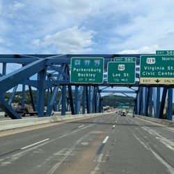
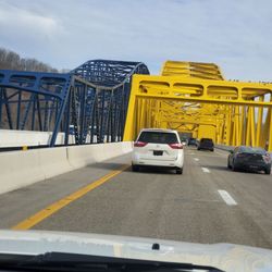
Officially the William S. Ritchie Jr. Bridge, the Ravenswood bridge connects Ravenswood West Virginia with Meigs County Ohio. It was completed in 1981, replacing a ferry service that operated here at least to 1908. It carries US Route 33 across the Ohio River. It is a cantilever bridge with a total length of 2710 feet and a main span of 900 feet. There are two lanes. William S. Ritchie Jr. (1928-2006) was a pioneering civil engineer and public servant whose legacy helped shape West Virginia's modern transportation infrastructure. Ritchie served two terms as Commissioner of Highways for the state, first in 1968 and again in 1985, overseeing the planning and construction of hundreds of miles of interstate and local roads--including the completion of Interstate 64 and the iconic New River Gorge Bridge. In retirement, he served three terms as Mayor of Ravenswood. There is no toll to cross the bridge. [Review 583 of 2025 - 167 in West Virginia - 24144 overall] read more


came across this bridge going to Columbus on a Saturday afternoon hot dog run out of northern carolina. access from the east involves circling a mobile home community fronting the river, to the west it's Ohio as far as the eye can see... named in honor of the former state highways commissioner the WSR bridge clocks in at just over 2700 feet long and about 75 feet above the water. completed in 1981 this wonderful specimen of cantilevered through trussedness spans the Ohio River at Ravenswood, West Virginia carrying US Route 33 towards Columbus and parts west. read more

More info about William S. Ritchie Jr. Bridge


William S. Ritchie Jr. Bridge - landmarks - Updated May 2026
Best of Ravenswood
People found William S. Ritchie Jr. Bridge by searching for…
Things to Do in Ravenswood, West Virginia
Places to Take Pictures in Ravenswood, West Virginia
Bridge in Ravenswood, West Virginia
Photo Spots in Ravenswood, West Virginia
Scenic Overlook in Ravenswood, West Virginia
View Points in Ravenswood, West Virginia
Tourist Attractions in Ravenswood, West Virginia
Public Services & Government in Ravenswood, West Virginia
Things to See in Ravenswood, West Virginia
Points of Interest in Ravenswood, West Virginia
Places to Run in Ravenswood, West Virginia
Castles in Ravenswood, West Virginia
Landmarks in Ravenswood, West Virginia
Lighthouses in Ravenswood, West Virginia
River in Ravenswood, West Virginia
River Walk in Ravenswood, West Virginia
Cave in Ravenswood, West Virginia
Historical Sites in Ravenswood, West Virginia
Night View in Ravenswood, West Virginia
Must See in Ravenswood, West Virginia
Waterfall in Ravenswood, West Virginia
State Park in Ravenswood, West Virginia
Trending Searches in Ravenswood, WV
Baseball Fields near William S. Ritchie Jr. Bridge
Botanical Gardens near William S. Ritchie Jr. Bridge
Bounce House Rentals near William S. Ritchie Jr. Bridge
Campgrounds near William S. Ritchie Jr. Bridge
Floral Designers near William S. Ritchie Jr. Bridge
Garden Center near William S. Ritchie Jr. Bridge
Hair near William S. Ritchie Jr. Bridge
Historic Homes near William S. Ritchie Jr. Bridge
Landmarks & Historical Buildings near William S. Ritchie Jr. Bridge
Nurseries & Gardening near William S. Ritchie Jr. Bridge
Outdoor Furniture Stores near William S. Ritchie Jr. Bridge
Party Equipment Rentals near William S. Ritchie Jr. Bridge
Pedicure near William S. Ritchie Jr. Bridge
Photo Spots near William S. Ritchie Jr. Bridge
Pick Your Own Farms near William S. Ritchie Jr. Bridge
Public Services & Government near William S. Ritchie Jr. Bridge
Browse Articles
Browse Nearby
BEST of Ravenswood, West Virginia Coffee near William S. Ritchie Jr. Bridge
BEST of Ravenswood, West Virginia Things to Do near William S. Ritchie Jr. Bridge
BEST of Ravenswood, West Virginia Parks near William S. Ritchie Jr. Bridge
BEST of Ravenswood, West Virginia Restaurants near William S. Ritchie Jr. Bridge
BEST of Ravenswood, West Virginia Museums near William S. Ritchie Jr. Bridge
BEST of Ravenswood, West Virginia Hotels near William S. Ritchie Jr. Bridge
BEST of Ravenswood, West Virginia Campgrounds near William S. Ritchie Jr. Bridge
BEST of Ravenswood, West Virginia Breakfast near William S. Ritchie Jr. Bridge
Browse Brands
Related Searches in Ravenswood, WV
Beautiful Flower Fields in Ravenswood, West Virginia
Best Fishing Locations and Guides in Ravenswood, West Virginia
Best Lookout Points to Visit in Ravenswood, West Virginia
Discover Charming Historic Homes in Ravenswood, West Virginia
Discover Family-Friendly Aquariums in Ravenswood, West Virginia
Discover Famous Monuments in Ravenswood, West Virginia
Discover Fun Things to Do Alone in Ravenswood, West Virginia
Discover Historic Sites and Places in Ravenswood, West Virginia
Discover Popular Landmarks in Ravenswood, West Virginia
Discover Popular Photo Spots in Ravenswood, West Virginia
Discover Top Nature Parks to Visit in Ravenswood, West Virginia
Discover the Best Interactive Museum in Ravenswood, West Virginia
Enjoy Hiking Adventures in Ravenswood, West Virginia
Enjoy the Best Night View Spots in Ravenswood, West Virginia
Enjoy the Best Walking Trails in Ravenswood, West Virginia
Experience Stunning Sunset Views in Ravenswood, West Virginia
Explore Beautiful Castles and Landmarks in Ravenswood, West Virginia
Explore Beautiful Parks and Green Spaces in Ravenswood, West Virginia
Explore Children's Museums Near Ravenswood, West Virginia
Explore Free Things to Do Around Ravenswood, West Virginia
Explore Popular Scenic Views Near Ravenswood, West Virginia
Explore Popular View Points Around Ravenswood, West Virginia
Explore Scenic Lakes to Visit in Ravenswood, West Virginia
Explore Secret Spots Worth Visiting in Ravenswood, West Virginia
Explore Top Art Galleries Located in Ravenswood, West Virginia
Explore Venues & Event Spaces in Ravenswood, West Virginia
Explore the Top Car Museum in Ravenswood, West Virginia
Find Beautiful Views in Ravenswood, West Virginia
Find Top Art Museums in Ravenswood, West Virginia
Find Top Libraries to Visit in Ravenswood, West Virginia
Find the Best Bridge Spots in Ravenswood, West Virginia
Find the Best Playgrounds to Visit in Ravenswood, West Virginia
Get Your City Pass for Attractions in Ravenswood, West Virginia
Popular Kids Activities in Ravenswood, West Virginia
Popular Places to Take Pictures in Ravenswood, West Virginia
Popular Places to Walk Around in Ravenswood, West Virginia
Popular Things to Do in Ravenswood, West Virginia
Popular Things to See in Ravenswood, West Virginia
Public Services & Government Offices in Ravenswood, West Virginia
Secure Convenient Parking Options in Ravenswood, West Virginia
See Top Fireworks Events in Ravenswood, West Virginia
Top Entertainment Options in Ravenswood, West Virginia
Top Hiking Trails to Explore in Ravenswood, West Virginia
Top Historic Restaurants to Try in Ravenswood, West Virginia
Top Places to Visit in Ravenswood, West Virginia for Sightseeing
Top Things to Do With Kids in Ravenswood, West Virginia
Tour Famous Lighthouses Located in Ravenswood, West Virginia
Visit Popular Museums in Ravenswood, West Virginia Now
People who viewed William S. Ritchie Jr. Bridge also viewed
Sarvis Fork Covered Bridge
2 reviews
Harry Ripley Memorial Bridge
1 review
Teens Run Bridge
1 review
West Virginia & Ohio Historical Marker
1 review
Jackson County Marker
1 review
Washington's Land Historical Marker
1 review
Ravenswood Ohio River Ford Historical Marker
1 review
Point Pleasant Historical Marker
1 review
Historic Fort Randolph Monument
1 review
Daniel Frost Historical Marker
1 review