Trillium Falls Trail Photos


You might also consider
More like Trillium Falls Trail
Recommended Reviews - Trillium Falls Trail
Start your review...

This is coming from a middle aged out of shape non-hiker. This trail is a trial for a person like me. Steep-ish in places, roots to stumble over and crazy long...2 hours of walking when you are not used to going on trails like this? Holy crap. They could have done a huge public service and placed a restroom mid way through as well. It was easy to find parking in September. I parked right next to the trailhead thinking this was going to be a 45 min flat jaunt. I was so wrong! There are proper restrooms next to the parking lot with flush toilets and non potable sink water. It is beautiful though and you can really get an immersive redwood experience. The falls themselves are kinda baby falls compared to others I've seen. read more


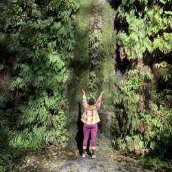
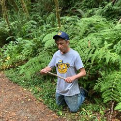
I hiked two of my favorite hikes in one day while exploring the Redwood Coast - Lady Bird Johnson Grove and Trillium Falls. This is such an amazing hike and easy to do. Trillium Falls Trail is a 2.6 mile loop trail off the 101 near Orick that starts off in the Elk Meadow Day Use area. It is part of Redwood National Park. Parking is at Elk Meadow and there are plenty of spots. The loop trail climbs a hill with switchbacks to a steel bridge over Trillium Falls. This shady redwood forest is so beautiful. There are redwoods and ferns everywhere. The sun peeking through the trees is just gorgeous on sunny days. The waterfall is small but makes for nice photos. The trail then loops around back around to the parking lot. I highly recommend doing this nature hike. It is one of the prettiest hikes in the park. read more


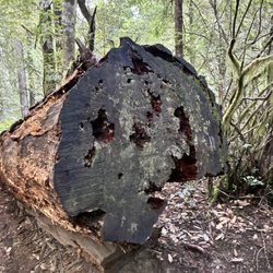
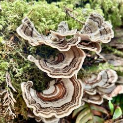
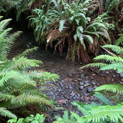
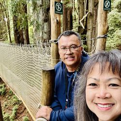
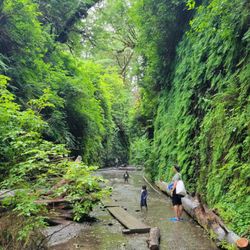
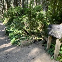
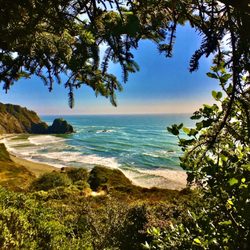
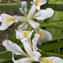
Beautiful, otherworldly hiking trail! My favorite one inside the Redwood National Park. You'll be hiking amongst the giants almost the whole way! The trail features a somewhat small, but absolutely lovely waterfall, fallen giants to climb under, and fern covered forest floors with tons of giant redwoods and other moss covered trees! Well, you don't have to actually "climb" under them - they're so huge that I was able to stand fully upright and just walk directly underneath the fallen behemoths! This awesome trail puts you right in the middle of old growth Redwoods, tons of ferns, and even carpets of clovers in the spring! We hiked it around St Patrick's Day so I thought it was clover but it's actually called Oxalis and is a native "redwood sorrel" plant. It's lovely to look at though and even has a deep purple hue on the bottom of its leaves! There are so many giant redwoods along this trail - it's just incredible! Made me feel so tiny haha! And every now and then, when there's a break in the trees, you get a lovely view of the mountains/hills in the distance. You may also notice an occasional, slight "skunk" sort of smell as you wander along. The culprit for the smell is a gorgeous little plant called "skunk cabbage" that resembles a Lilly with yellow, cup-shaped flowers! They were everywhere!! The trail is named for the abundant trillium flowers but sadly I didn't see any blooming yet. AllTrails has it listed as moderate, but I actually found it to be fairly easy. And I don't think all of AllTrails measurements are accurate - they have it as 2.6 miles but I ended up doing a total of 3.5 miles. You'll gain around 460 feet in elevation- but it's so gradual that it seems effortless almost - definitely doable. The trail is well marked with plenty of signage along the way and isn't technical at all. The worst issue we had was it gets fairly muddy in places, but it's easy to navigate around. If you go counter-clockwise (aka go right at the trailhead), then the waterfall is about 1/2 mile in - so if you don't want to do the whole trail, you can see the waterfall easily and it still makes for a nice hike - however, I recommend the whole trail bc the Redwoods are just mind blowing! And there are lots of benches along the way for rest stops - several of them even have some lovely, inspiring dedication plaques! The trailhead is found in the Elk Meadows day use area, about 5 miles into the park from the Thomas H Kuchel visitor center. It's very easy to find - in fact, I just typed "Trillium Falls Trail" into my GPS and it found it and took me straight here - no issues! There's plenty of paved parking, picnic tables, and even surprisingly spotless bathrooms! This trail isn't handicap accessible - but there are actually quite a few trails throughout this area and one of them is - I believe it's the Davison Loop trail. There are several trail maps along the way so it's easy to get around on any of the trails here. read more


3 years ago
Trillium Falls barely classifies as a waterfall but the ~3 mile loop trail was an easy and enjoyable hike. The redwoods were pretty spectacular. read more


4 years ago
More info about Trillium Falls Trail
Ask the Community - Trillium Falls Trail


Trillium Falls Trail - hiking - Updated June 2026
Best of Orick
People found Trillium Falls Trail by searching for…
Things to Do in Orick, California
Visitor Centers in Orick, California
Hiking Trails in Orick, California
Waterfalls in Orick, California
Redwood Trees in Orick, California
Picnic Areas in Orick, California
Natural Hot Springs in Orick, California
Places to Take Pictures in Orick, California
Scenic View in Orick, California
Scenic Overlook in Orick, California
Beautiful Views in Orick, California
Sunrise View in Orick, California
Photo Spots in Orick, California
Picnic Spots in Orick, California
Sunset View in Orick, California
Rock Quarry in Orick, California
Off Road Trails in Orick, California
Dinosaur Park in Orick, California
Swimming Holes in Orick, California
Things to Do on a Rainy Day in Orick, California
Trending Searches in Orick, CA
Berry Picking near Trillium Falls Trail
Boat Rental near Trillium Falls Trail
Cliff Jumping near Trillium Falls Trail
Day Trips near Trillium Falls Trail
Fireworks near Trillium Falls Trail
Fishing Spots near Trillium Falls Trail
Kayak Rental near Trillium Falls Trail
Public Shower near Trillium Falls Trail
River Swimming near Trillium Falls Trail
Scenic Overlook near Trillium Falls Trail
Browse Articles
Browse Nearby
BEST of Orick, California Restaurants near Trillium Falls Trail
BEST of Orick, California Coffee near Trillium Falls Trail
BEST of Orick, California Breakfast near Trillium Falls Trail
BEST of Orick, California Things to Do near Trillium Falls Trail
BEST of Orick, California Campgrounds near Trillium Falls Trail
BEST of Orick, California Attractions near Trillium Falls Trail
Browse Brands
Related Searches in Orick, CA
Best Fishing Locations and Guides in Orick, California
Best Nature Trails for Hiking in Orick, California
Best Spots for Star Gazing in Orick, California
Check Out Off Road Trails in Orick, California
Discover Lakes & Ponds to Explore in Orick, California
Discover Popular Bike Trails in Orick, California
Discover Popular Photo Spots in Orick, California
Discover Top Boat Tours in Orick, California for All Ages
Discover Top Nature Parks to Visit in Orick, California
Discover a Hiking Trail in Orick, California
Discover the Best Running Track in Orick, California
Discover the Best Tide Pools in Orick, California
Dog-Friendly Hikes With Dogs in Orick, California
Enjoy Camping Adventures Around Orick, California
Enjoy Kayaking Adventures in Orick, California
Enjoy Scenic Night View Experiences in Orick, California
Enjoy Tent Camping Spots Around Orick, California
Enjoy the Best Night View Spots in Orick, California
Experience Stunning Sunset Views in Orick, California
Explore Beautiful Parks and Green Spaces in Orick, California
Explore Easy Hikes Perfect for All in Orick, California
Explore Popular Campgrounds Near Orick, California
Explore Popular RV Parks Around Orick, California
Explore Popular Scenic Overlook Points in Orick, California
Explore Popular View Points Around Orick, California
Explore Scenic Lakes to Visit in Orick, California
Explore the Best Beach Spots in Orick, California
Explore the Best Boating Spots in Orick, California
Explore the Best Trail Options in Orick, California
Family Friendly Hiking With Kids in Orick, California
Find Beautiful Views in Orick, California
Find Cozy Camping Cabins in Orick, California
Find Fun Kids Activities Outdoor in Orick, California
Find Parks and Recreation Activities in Orick, California
Find the Best Scenic View Locations in Orick, California
Hiking Trails With Waterfalls in Orick, California
Must-See Tourist Attractions Around Orick, California
Off Leash Dog Hiking Trails in Orick, California
Perfect Spots to Watch Sunset in Orick, California
Plan a Scenic Drive Route Near Orick, California
Popular Kids Activities in Orick, California
Popular Outdoor Activities to Try in Orick, California
Popular Picnic Spots to Visit in Orick, California
Popular Places to Take Pictures in Orick, California
Popular Things to Do in Orick, California
Relax at Natural Hot Springs Near Orick, California
Safe River Swimming Areas in Orick, California
Top Playgrounds for Kids to Enjoy in Orick, California
People who viewed Trillium Falls Trail also viewed
Redwood National & State Parks
123 reviews
Prairie Creek Redwoods State Park
136 reviews
Fern Canyon Trailhead
23 reviews
Axel Lindgren Memorial Trail
5 reviews
Cathedral Trees Trail
1 review
Sue-Meg State Park
129 reviews
Endert's Beach
16 reviews
Yurok Loop Trail
1 review
Gold Bluffs Beach & Campground
17 reviews
Stone Lagoon RV Park
3 reviews