1. Ptarmigan Creek Trail

0

Crownpoint, AK

Cancel

Open app

Search

Ptarmigan Creek Trail

5.0 (1 review)

Ptarmigan Creek Trail Photos
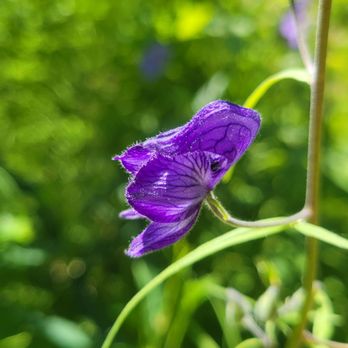
More like Ptarmigan Creek Trail

Recommended Reviews - Ptarmigan Creek Trail

Your trust is our priority, so businesses can't pay to alter or remove their reviews. Learn more about reviews.
Yelp app icon
Browse more easily on the app
Review Feed Illustration
Photo of Joy L.
170
1660
9775

4 years ago

Helpful 4
Thanks 0
Love this 2
Oh no 0

Verify this business for free

Get access to customer & competitor insights.

Verify this business

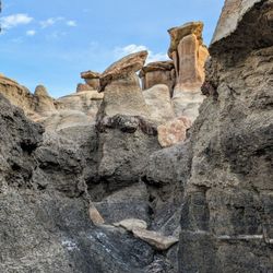
Bisti/De-Na-Zin Wilderness - Look ma, I'm on top of the world !

Bisti/De-Na-Zin Wilderness

4.5(13 reviews)
37.8 mi

Loved loved LOOOOOVED it here !!! It felt like I was on a alien planet! We took our Jeep and got to…read moredrive around. We literally was outside, about to hike & it started POURING rain on us! We drove 2 hours to get here & got to play around for 25 minutes but it was one of my favorite 25 minutes. Because of the sudden rain storm we got to go mudding, which I always love. But you MUST hurry to the front, you may get trapped on the other side of the entrance if it rains & the trench (which is SUPER deep) fills up. DO NOT try to cross if it fills up !! You will drown. We hurried & it was already 1/4 filled & we got there only 10 minutes after the rain started.

If you're unfamiliar with the area but an avid hiker, Bisti Badlands is an amazing area to check…read moreout on your own, so long as you've come prepared with GPS coordinates, maps, and parking advice. I have no affiliation with it, but we used Firefall Photography's website for excellent resources on all of that, including pinpoints for the north/south parking areas. As experienced hikers (Grand Canyon, Utah parks, Himalayas, etc.), we know our limitations, including the fact that our GPS apps often make quirky jumps in extremely remote areas, so we tried to pick and choose our priorities, ultimately deciding that we could manage the Bisti portion by ourselves. (We did the De-Na-Zin side the following day, with a guide. We had limited time to explore and didn't want to waste it false-navigating to permitted parking sites or major landmarks on our own, especially in monsoon season, so we signed up for the Ah-Shi-Sle-Pah tour offered by Navajo Wilderness Adventures for that area -- absolutely wonderful!) On our independent day at Bisti, we arrived around 3 p.m., and a few sprinkles started just after 7 p.m., cutting off our desire to stay into the golden/blue hours, but it's worth visiting no matter the time of day. Since we had only one sunrise moment to spend there, we decided to end at Wings, despite having read that the Eggs don't photograph well in brighter light, and we were pleased with that choice in the end, since we had "near sunset" at the gorgeous hill of wings. Overall, in just under five hours, we made it from the Eggs to the Wings and hit nearly every major formation in between, including the Rock Garden, petrified wood, Hoodoo City, Vanilla Hoodoos, Manta Ray, and more. We found that some of our GPS points didn't quite match the Firefall map (including at the Beige Hoodoos and Manta Ray), but going armed with general AllTrails locations, Firefall and AllTrails maps, Gaia, and a tiny print map with photos made it all come together, allowing us plenty of time to photograph the landscape from vantages up, down, and all around. The relatively flat terrain made our nine miles of hiking relatively simple (but do avoid it after rain where possible), and it was a fantastic journey -- such mesmerizing formations and astounding landscape!

Photos
Bisti/De-Na-Zin Wilderness - Instagram: @telephonesmoothie

Instagram: @telephonesmoothie

Bisti/De-Na-Zin Wilderness - Instagram: @telephonesmoothie

Instagram: @telephonesmoothie

Bisti/De-Na-Zin Wilderness - We loved it here!!

See all

We loved it here!!

Chaco Culture National Historical Park - Moderate trail

Chaco Culture National Historical Park

4.6(55 reviews)
27.5 mi

This review is for Pueblo Bonito Overlook Trail which was a ~2 miles round trip that took ~1.5…read morehours to complete. About ~20 miles of driving through light snow over dirt road on Navajo Service Rte 14 (From Petrified Forest NP). A little bit of steep incline and rock scrambling behind the Kin Kletso near the beginning of the trail. This will take you through a slot canyon and up to the mesa. Follow the ridges until you reach the "End of trail" sign which is the Pueblo Bonito Overlook. Look for the trail marker for the descent back down. Beautiful views from the top of the mesa! Short video of the hike for those interested! https://youtu.be/qL4yU22HJ3U

My brother, dad and I had an amazing experience at Chaco Culture National Historic site. We felt…read morevery fortunate to be able to visit such a magical place. I wont go into details, but it is worth the trip to come see this place at-least once in your lifetime and feel the energy that is here. We came in through the south rim off the 57. It is about a good 20 mile drive on a rough dirt road. I would not recommend driving here in any low profile vehicles or when it is raining because you will get stuck in the mud. Make sure your tires are good. Some patches are very rough and you will literally need to drive around 15mph. Once you reach near the visitor center there is paved road again. The loop is all paved and individual parking sites with restrooms are located in every site and will lead you on the trails. The hikes are moderate, but look out for snakes. The visiting section has a gift shop, really nice restrooms and they will provide all the info you may need. Entrance fee was only $25.

Photos
Chaco Culture National Historical Park

See all

Canyon de Chelly National Monument - Bathrooms at White House trail end

Canyon de Chelly National Monument

4.6(74 reviews)
78.3 mi

I visited here a few times in high school when I did volunteer trips to the reservation. We would…read morevisit Canyon de Chelly on our free day after a long week of work. Canyon de Chelly National Monument is a huge canyon park on tribal lands that was habited by several Native American peoples many years ago. There are many areas that you can explore that have overlooks, hiking trails and remains of ancient Pueblo villages. The biggest attractions are the 800-feet tall Spider Rock spire and the White House ruin. Canyon de Chelly (pronounced de-SHAY) is located near Chinle in Northeastern Arizona. Even though it is a National Monument, the Navajo Nation entirely owns it. Around forty Navajo families live in the park. Other than the White House Trail, access to the canyon floor is restricted unless you book a tour guide. There are roads on both the North and South Rim where you can see ancient ruins and geologic structures. Canyon De Chelly has a visitor center with park rangers on hand and a gift shop. I was here recently and did the South Rim Drive. You can see ruins from the overlooks on South Rim Drive if you have binoculars. They are a little hard to see without them. This drive is the more popular side of the canyon because you can see Spider Rock and the White House ruin while on this road. On this drive are the Tunnel, Tsegi, Junction, White House, Sliding House, Face Rock and Spider Rock overlooks. Each overlook offers a unique perspective of the canyon floor and Navajo farmlands. We were able to do the White House Trail while here. It is the only trail that allows you to visit the bottom of the canyon without a guide. The hike is 2.5-miles round trip and descends nearly 600 feet to the canyon floor and back up. There are a few spots that can be a little slippery when raining. The end of the trail allows you to get up close to the White House ruin. This famous 1,000-year-old cliff dwelling was built by Ancestral Puebloans around 1060 AD. The White House has around 80 rooms and is named for the white plaster still visible on the walls. The hike itself isn't bad and worth it if you have some time. We had a nice time here at Canyon de Chelly. It brought back many memories of when I came here as a teenager. There are vendors at some of the overlooks that sell jewelry and other items. I wish we had more time to do the North Rim Drive to see the Massacre Cave Overlook. A sad event occurred here in 1805 when over a hundred Navajo people were murdered by the Spanish military while hiding in a cave.
I unfortunately didn't have time to go on a guided tour of Canyon de Chelly (it's located in the…read moreNavajo Nation, so you need to have a licensed tour guide to enter the majority of the Canyon), but I visited the welcome center, both the north and south rim drives, and hiked the White House Trail. The welcome center is staffed with NPS rangers and volunteers. There's a small gift shop and museum area with exhibits. There's also a hogan outside and you can ask the ranger to give a hogan talk and even enter it. The rim drives are gorgeous, although dusk and dawn really bring out the colors. The canyon rims are quite sheer which is different from a lot of other canyons. Pueblos can be seen from several lookouts, so bring binoculars. There tends to be people selling artwork and jewelry at the lookouts, so if you're interested, bring cash. The White House Trail is the only publicly accessible trail without a guide. It starts at the lookout, and you can see the structure from the parking lot, or decide to hike down to get a closer look (it's fenced off with a chain link fence to avoid people not respecting it). The hike is 2.5 miles round trip with little shade (although does have two cool tunnels), so bring water.

Photos
Canyon de Chelly National Monument - Face Rock Overlook View Finder

Face Rock Overlook View Finder

Canyon de Chelly National Monument - National Park map

National Park map

Canyon de Chelly National Monument - Visitor Center

See all

Visitor Center

Ptarmigan Creek Trail - campgrounds - Updated October 2026

Loading...
Loading...
Loading...