Cancel

    Open app

    Search

    North Canton School House

    3.0 (1 review)

    North Canton School House Photos

    Recommended Reviews - North Canton School House

    Your trust is our priority, so businesses can't pay to alter or remove their reviews. Learn more about reviews.
    Yelp app icon
    Browse more easily on the app
    Review Feed Illustration

    11 months ago

    Helpful 13
    Thanks 2
    Love this 10
    Oh no 1

    Verify this business for free

    Get access to customer & competitor insights.

    Verify this business

    Collins Company Axe Factory - View from the inside: imagine being a worker from 1826 to 1966.

    Collins Company Axe Factory

    5.0(1 review)
    6.6 mi

    This historic landmark still stands after all these years. Currently, one of the buildings is a…read moreretail building called Antiques on the Farmington. It's strategically placed on the Farmington River so that dams could be built to create a power source. Eventually, the railroad was built near it so goods could be sent out to be sold. The large bridge nearby was part of the railroad and is now a beautiful walking path for residents near and far. Collinsville became a village because of this famous axe company. The Collins Company opened in 1826 and was known to create the first ready to use axes in America. They also produced and sold machetes and other tools. The building that the axe company was in used to be a gristmill. The company started off with only 8 men and once it got popular, they employed workers from all over the state and nearby states. Housing was built for these workers and their families as well as other town/village necessities; those buildings were a church, bank, shops, etc. As the company expanded, they sold machetes and other tools all over the world. Unfortunately, nothing lasts forever. The Collins brothers died and eventually the floods of 1955 destroyed the railroad, which halted their sales. Due to competition, the deaths of the owners, a natural disaster, the company closed in 1966. It was a good 140 year run though; the Collins left their legacy and we can surely feel their spirit by just walking around downtown and in the old axe factory. The remnants of this factory still stands strong. I really enjoyed walking on the path and looking at the building. There's so much history and definitely some ghostly feels.

    Photos
    Collins Company Axe Factory - The bridge near the factory

    The bridge near the factory

    Collins Company Axe Factory - The factory

    The factory

    Collins Company Axe Factory - See the old sign? "The Collins Co"

    See all

    See the old sign? "The Collins Co"

    Heublein Tower

    Heublein Tower

    5.0(1 review)
    7.0 mi

    Heublein Tower is located in Talcott Mountain State Park. There were plenty of parking spaces and a…read morefew trails that lead up to the "castle". The main Tower Trail is 1.25-miles one-way; most of it were up hill and on rocky gravel. There were a couple of lookouts before reaching the tower; beautiful views but becareful, it's very steep. There were a couple of benches and waste receptacles along the way. The tower up close was magnificent and the land is full of history. There was the old garage that's used as an information center with benches and a video. A huge picnic pavilion and BBQ pit. The Tower was built to look like a German castle. There are 6-stories; bedrooms, living rooms, restrooms, and the ballroom which is now called the observation deck are in it. There were signs showing what certain areas were. This building was Gilbert Heublein's summer home, then The Hartford Times, then the State of CT. Many parties and famous people have traversed these steps; Dwight D. Eisenhower and Prescott Bush to name a couple. The observation deck is where the showstopper is; 360-degree views of Connecticut, it's a priceless and breathtaking view. Thank you to Connecticut Department of Energy and Environmental Protection and Friends of Heublein for up keeping and keeping this local and historical gem alive. I highly recommend the moderate hike up, if you're able to. Bring bug spray, water, sunscreen, a hat, sunglasses, and your best hiking boots!

    Photos
    Heublein Tower
    Heublein Tower
    Heublein Tower

    See all

    Simsbury Revolutionary War Memorial - Landscaping is pretty

    Simsbury Revolutionary War Memorial

    5.0(1 review)
    5.1 mi

    This memorial is located inside Simsbury's historic cemetery behind it's metal gates that run along…read moreHopmeadow Street. The cemetery is the final resting place for several of the town's Revolutionary War veterans. The memorial consists of a bronze plaque mounted on a flat stone. The top of the plaque has a color image of the continental flag and an image of a colonial soldier. The plaque's inscription reads: 1775 - 1783 We, the people of the Town of Simsbury, do hereby recognized the many hardships and countless sacrifices made by all those brave American Revolutionary Soldiers; especially those from Simsbury, who died for our freedom from England. We hereby dedicate this bronze memorial plaque as an everlasting tribute to these American heroes, whose gallant and brave efforts brought us to the birth of the United States of America and adoption of the Constitution. To these courageous countrymen, we are eternally grateful. Thirty three names and their ranks follow, and it's interesting to see so many different titles -Fifer, Private, Ensign, Captain, Major, Lieutenant, Corporal. The memorial was funded by the Ensign Bickford Company and dedicated on Veteran's Day, November 11, 2005. The simplicity of the memorial, the vibrant color of the flag emblem, the quiet setting of the cemetery, and the knowledge that Revolutionary War veterans are buried there, combine to make a pretty powerful statement.

    Photos
    Simsbury Revolutionary War Memorial - Nice mid summer night to walk with the hubby

    Nice mid summer night to walk with the hubby

    Simsbury Revolutionary War Memorial - View of the cemetery behind the memorial

    View of the cemetery behind the memorial

    Simsbury Revolutionary War Memorial - Beautiful grounds

    See all

    Beautiful grounds

    Winchester Center Historical Marker

    Winchester Center Historical Marker

    4.0(1 review)
    12.4 mi

    This is one of those state signs in every town, village, and "used to have people living here"…read moreplace in Connecticut. Winchester Center is closest to the la as t of those categories. It's very pretty, and people do live there, but if you need a bottle of milk you're driving at least 20 minutes. Anyway, it does warrant itself a sign from the state, titled "Winchester Center, 'The Old Society'" and reads: The first ecclesiastical society of Winchester was incorporated by the central assembly of the colony of Connecticut at its May session, 1768. The following year, a small, low, steeple-roofed building was erected for a meeting house about 7/10 of a mile south of the present Winchester Center Green;a rough granite post marks the site. The first census of the colony, taken in 1756, has 24 as the population of the entire town of Winchester. The next census, taken in 1774, shows 327 whites, 12 blacks. The Congregational Church was formed October 30, 1771, with 14 members. Only five years after the erection of the first house of worship, a committee was sent from the county court at Litchfield "to pitch the stakes" for a meeting house at the 'center'. On October 11, 1785, Dr. Josiah Everett deeded to the society for the sum of 1 £, 16s and 3d "lawful money" for a certain piece of land containing 56 1/2 rods "to build a meeting house on for divine worship, and for a suitable green around the same." In 1786 a new edifice was erected on this Green. The whipping post and stocks, those indispensable pillars of New England law and order, stood nearby on the green. The post served also for the posting of public notices. The third church, Greek revival with a Doric portico and facade of matched boards, was erected in 1841. Just north of the green, land was provided by 'Squire' Issac Bronson; with the stipulation that no building was ever again to be erected on the green. Our father's built shelter for their families and stock, then the church of God, then the school house. The early records of the town do not contain any accounts of building the first public schoolhouse. However, there is no doubt such buildings were erected. The 'chapel', across Winchester road from the church, began its existence as 'the Academy' finances by a group of investors "who purchased rights payable in higher education for their children." The Winchester institute (which stood some 700 north of the center green) a commodious seminary building opened in 1858 as a boarding and day school. It was the seat of learning for such great men as Dr. Fredrick S. Dennis and Dr. William H Welch (the latter discovered "ether"); after use as a seminary it became The Hill View Inn (destroyed by fire in 1929). The center had at one time two country stores, the Bronson Bros at the north side of the Green and S&L Hurlbut on Newfield Road. The latter building was acquired in 1895 by the Winchester Grange. Fire destroyed it in 1951 and the present grange hall was its replacement. 
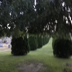
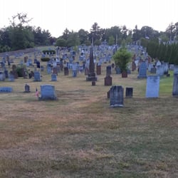
The Winchester Center cemetery, acquired Mar. 16 1773 and the Hurlbut family cemetery are on South road, about a mile south east. The Danbury Courier cemetery is on Benedict road part of the original Winchester Center Settlement. You can park across from the sign near the Grange hall, and dash across and see it. The sign itself is on a small triangle of land, and you'll undoubtedly be in the way of cars if you try to park there.

    Photos
    Winchester Center Historical Marker
    Winchester Center Historical Marker
    Winchester Center Historical Marker

    See all

    Hollow Church Bell

    Hollow Church Bell

    4.0(1 review)
    3.9 mi

    Driving through the pretty countryside in Barkhamsted, I came across quite an unusual site - a…read morelarge metal bell sitting on top of two imposing stone pillars. The monument sits between two huge flagpoles, almost giving it the appearance of sitting inside a set of football goalposts. The bell is located on a green at the intersection of Pleasant Valley Road (Connecticut Route 318) and Beach Rock Road, adjacent to the Barkhamsted Center Cemetery. So here's the history of the bell. It's old - like 1834 old. It's from an old Barkhamsted Church named the Universalist Church. It was in the part of town known as Barkhamsted Hollow, so the Church was also known as the Hollow Church. Because the area was prone to floods, the immediate area was redesigned by the MDC in the late 1930's as many houses, farms, and that very Church were razed to build the Saville Dam in 1940. The Dam was meant to keep the nearby Farmington River in check and created the huge Barkhamsted Reservoir. The stone pillars contain two inscribed plaques that read: This bell hung in the Hollow Church which was relocated during construction of the Compensating Reservoir. It was cast in Hartford, CT in 1834. Dedicated 1997 These boulders were provided by the generosity of the Metropolitan District Commission. There were part of the Saville Dam spillway and washed out in the 1955 flood. It's quite the cool landmark, Reminds me of an old Chuck Berry song about some guy........"who never ever learned to read or write so well, but he could play the guitar like ringing a bell...."

    Photos
    Hollow Church Bell
    Hollow Church Bell
    Hollow Church Bell

    See all

    Canton Veterans Memorial

    Canton Veterans Memorial

    4.5(2 reviews)
    6.4 mi

    This memorial is located in historic Collinsville, on the corner of River and Bridge Streets and…read moreerected in 2001. It sits across from the Farmington River as well as the Collinsville walking trail, boat ramp, and flower bridge. The showstopper is the old cannon. This cannon was built in New York for World War I. The memorial is for those who sacrificed their lives in the World, Korean, and Vietnam Wars. There's a stone engraved with all the soldiers' names that served and were from Canton/Collinsville. Here is a quote on the marker: "In grateful memory of the men who died in the service of their country and in recognition to all men and women who served that freedom might live, this monument stands so that future generations will always remember."

    When driving on Rte. 179 in Collinsville, you might glimpse a huge gun by the side of the road…read morefacing North. No, it's not an old-fashioned GPS, but a World War One carriage gun that shares a small Town Green with a Veterans Memorial and a flagpole. The monument is shaped in a "V" and lists the names of Canton's veterans who perished in World War One (5 names), World War Two (16 names), the Korean War (2 names), and the Viet Nam War (2 names). There is an American flag inscribed at the top left corner of the "V". An inscription on the left side reads: In grateful memory of the men who died in the service of their country and in recognition to all men and women who served that freedom might live this monument stands so that future generations may always remember. A flagpole with the American flag and Vietnam MIA flag share the site with the gun and monument

    Photos
    Canton Veterans Memorial
    Canton Veterans Memorial
    Canton Veterans Memorial

    See all

    White Memorial Fountain

    White Memorial Fountain

    5.0(1 review)
    5.6 mi

    One more example of the incredibly rich history that can be found in every corner of our state. The…read moreWhite Fountain is located on the Southbound side of Hopmeadow Street, pretty much across the street from Abigail's Restaurant, where Route 202/10 intersects Route 185. The Fountain honors Dr. Roderick White (1809-1887), who dedicated nearly 50 years of his life traveling around the Simsbury area by horse to practice medicine and offer healthcare advice to the community. He studied medicine at Yale, and began his medical career in Manchester and Granville before he settled in Simsbury in 1842. Dr. White passed away in 1887, and his wife Elizabeth passed away two years later. Her will stated "I desire to leave a memorial of my late husband in the community where he so long lived and practiced his profession, and for that purpose I have determined that it would be suitable and proper to erect in the village of Weatogue a memorial fountain supplied with running water." A granite base supports the granite fountain. There is a large basin with lion heads, and three round basins above. Decorations on the fountain include a portrait of Dr. and Mrs. White, a sculpture of a Healing Serpent (symbol for medical profession),an engraving of Hippocrates, and an inscription honoring Dr. White. The inscription reads: In Memory of Roderick A. White, M.D., who died Dec. 2, 1887. The beloved Physician of this town for nearly fifty years. Erected by his wife, Elizabeth Hungerford White. Defunctus adhunc ministrat I popped that phrase into a Latin to English Google Translate and came up with "Died hitherto serveth"

    Photos
    White Memorial Fountain
    White Memorial Fountain - Fountain Panel with dedication

    Fountain Panel with dedication

    White Memorial Fountain

    See all

    North Canton School House - landmarks - Updated May 2026

    Loading...
    Loading...
    Loading...