Cancel

    Open app

    Search

    McLain State Park

    5.0 (1 review)

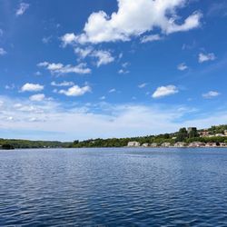
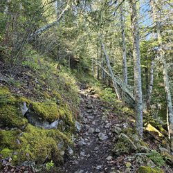
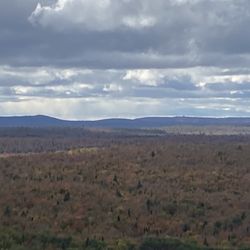
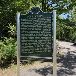
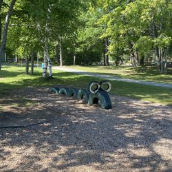
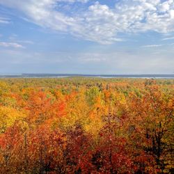
    McLain State Park Photos

    Recommended Reviews - McLain State Park

    Your trust is our priority, so businesses can't pay to alter or remove their reviews. Learn more about reviews.
    Yelp app icon
    Browse more easily on the app
    Review Feed Illustration

    11 months ago

    Helpful 1
    Thanks 0
    Love this 0
    Oh no 0

    Verify this business for free

    Get access to customer & competitor insights.

    Verify this business

    Houghton Waterfront Park

    Houghton Waterfront Park

    5.0(6 reviews)
    8.2 mi

    This Waterfront Park really embodies what the town of Houghton, Michigan is all about…read more Houghton, Michigan (in my opinion) is a pretty cozy/old fashioned/industrial city with this terrific Waterfront Park situated along the edge of Portage Lake within the Keweenaw Waterway. The main highlight is a pedestrian walking pathway, where all you have to do is stroll about and breathe in the fresh air of the UP - Upper Peninsula. Plus, another scenic aspect of the park is having the Portage Lake Lift Bridge as the centerpiece focal point, making for quality photo opportunities (especially when the sun is out, lol) for those visitors exploring around town. And...the Portage Lake Lift Bridge connects the cities of Houghton and Hancock, which the road eventually leads towards Copper Harbor, MI - "The Gateway to Isle Royale National Park". For me coming to Houghton on my eventual journey out to Isle Royale...I very much enjoyed becoming acquainted with the city. Btw, there is an Isle Royale Visitor Center right nearby here for those interested in purchasing souvenirs, watching a park film and having your NP Passport stamped. Overall, this Waterfront Park gave me a fresh perspective for appreciating what makes Houghton quite the charming town. I used about 1 hour just casually hanging out here, taking some time to sit down on one of the many benches to relax and people watch.

    Parked by the water and went to dinner. After walked i bit around town and by the water. Peaceful…read moreand seems very safe. nice to be on vacation and not have to feel you need to be on alter and didn't see any homeless on the Upper P trip. Houghton is a college town ... several bar and restaurants. Water sports, fishing, hiking. This was our last stop on our Upper P trip. We actually went home a day early .. missed the dog. hope to return in the fall or spring ... especially the fall.

    Photos
    Houghton Waterfront Park
    Houghton Waterfront Park
    Houghton Waterfront Park

    See all

    Isle Royale National Park - Exhibit of furs and video

    Isle Royale National Park

    4.6(14 reviews)
    8.2 mi

    This is one of the least visited national parks, and it's not because it isn't worth visiting…read more Rather, it's so isolated that it needs a 3-6 hr ferry ride or a 45-60 min sea plane ride. Even then, there's only one hotel to stay in which is usually booked out pretty far in advance, unless you want to camp with potable water sources not the most reliable. Of course, this is by design in order to preserve the beautiful natural wilderness. I visited in the shoulder season in the first week of June, and there weren't that many people, emphasizing the wild solitude. It seems like all the visitors here are respectful of nature since there was not any litter nor any defacing at all. The trails here are primitive and not paved or lined with gravel. You can see so much wildlife here, from tiny amphibians the size of my fingernail to huge moose. The night sky is amazing with so many stars, and I saw the Milky Way due to the high quality of the night sky. It is very humbling. As a note, limited amounts of foraging is allowed. I didn't take anything, but I saw edible mushrooms and fiddleheads, and later in the season there's wild blueberries, strawberries, and thimbleberries. Even though it is early before the first hatch, the mosquitoes here are ferocious!

    Isle Royale is a unique GEM in the National Park system. If…read moreyou want a beautiful, unique, and wild place with no tv and limited Wi-Fi Isle Royale is for you. I took the Sea Hunter 3 from Grand Portage, Minnesota. The Grace Point lookout trail from the Windigo Visitor's Center took me about two hours, I'm a 45 year old male in decent shape. The lodge is at the Rock Creek Visitor's Center, from the Windigo Visitor's Center this would be about a 40-50 mile hike, Isle Royale is HUDGE island. There are ferry's and sea planes to Rock Harbor. I would LOVE to come back and spend a couple of nights. Bring heavy duty bug spray and a bug cover for your head and hands. The rangers at the Windigo Visitor's Center are GREAT, the ranger in the picture gave an awesome presentation.

    Photos
    Isle Royale National Park - Example of trail quality

    Example of trail quality

    Isle Royale National Park - Great presenter

    Great presenter

    Isle Royale National Park - Grace Creek Overlook

    See all

    Grace Creek Overlook

    Brockway Mountain Drive

    Brockway Mountain Drive

    4.8(10 reviews)
    9.2 mi

    I'd like to mention the West Bluff Scenic View as the featured/primary highlight atop Brockway…read moreMountain and situated at the end of Brockway Mountain Drive. It is 1300 feet above sea level overlooking Lake Superior. Most tourists/visitors will hang out at West Bluff as sort of their reward to appreciate the surroundings hovering above Copper Harbor, MI. I was visiting back in the springtime of 2021 getting ready to take the Queen IV Ferry over to Isle Royale National Park. So...the day prior to my departure I was exploring around the sleepy town of Copper Harbor, Michigan and included this Brockway Mountain Drive as part of my activities. To arrive at the West Bluff Scenic View...you simply drive this 4-mile paved Brockway Mountain Drive until it can't go any further. And, the road begins just outside downtown Copper Harbor. While on the drive, I suggest first stopping at the Copper Harbor Overlook about 1/4 of a mile into the trek up the mountain. It can't be missed on the left hand side of the road and there'll be a scenic observation deck for you to admire the setting of the area. This overlook I believe is even better than the sceneries at West Bluff Scenic View. And between these two vista point spots, there's really no other landmark/attractions worthy of exiting your car for along the 4-mile road. Overall, the ambiance at West Bluff Scenic View was pleasant. I could envision how really picturesque the sights would be during autumn when the leaves start changing colors. In the end the landscape is good enough for hanging out 15 - 20 minutes and breathing in the fresh Upper Peninsula Michigan air. And Brockway Mountain Drive will take you about an hour or so to complete. It's short and simple.

    This drive is S-T-U-N-N-I-N-G in the fall…read more The colors, during peak time, are breathtaking. More than a few times my husband and I just repeated "WOW WOW WOW" to each other as we drove through. At the peak you can get a really incredible, nearly 360 view of the area below and Lake Superior and in the fall the colors are spectacular. Especially on a sunny day. FYI it can get pretty windy up there! And since it's near the lake you'll get that lake effect wind and temperature so plan for a few degrees cooler than you would experience in town. And also make sure your hat, if you're wearing one, is tightly upon your noggin or you'll have to do like I did and chase it down when it blows off!

    Photos
    Brockway Mountain Drive
    Brockway Mountain Drive
    Brockway Mountain Drive - Copper Harbor Overlook is quite scenic along Brockway Mountain Drive.

    See all

    Copper Harbor Overlook is quite scenic along Brockway Mountain Drive.

    Hunter's Point Park

    Hunter's Point Park

    3.0(1 review)
    36.8 mi

    Hunter's Point Park is a real real simple, quiet park situated right along the beach shores of Lake…read moreSuperior. It is specifically located at the very tippy top section of the UP - Upper Peninsula of Michigan in a town called Copper Harbor. I was here visiting, walking around and casually exploring the day before I was venturing off to Isle Royale National Park. And...Copper Harbor is the official "Gateway to Isle Royale". So...since I had a free day and some extra time before my departure...I figured why not spend an afternoon here at Hunter's Point Park simply taking in the fresh air and seeing what's offered. There's nothing really special to this park. Nothing exciting or memorable. It was fine being here for maybe an hour or so. But that's it. There weren't any monumental highlights. I guess what I liked most was it gave me a chance to do some relaxed hiking (or more like walking) and having the opportunity to look out onto the waters of Lake Superior. It is free to come to Hunter's Point Park, just about 1.5 miles outside of downtown Copper Harbor. At the entrance area parking lot...there will be an informative trailhead sign describing 3 trails to hike and a short boardwalk overlook point to stroll over towards. I hiked 2 of the trails which connect with each other and pretty much cover the entirety of the park. They were the North Shore Trail and the South Shore Trail. And combined...they only go for 8/10's of a mile. That's pretty short but that's how very small Hunter's Point Park is. Here's some details on the North and South Shore Trails, according to the trailhead sign.... "The Hunter's Point trail system is laid out in a figure eight pattern and consists of north and south shore trails that intersect near the middle of Hunter's Point. All the trails offer opportunities for viewing watercraft, wildlife, wild flowers, boreal forests, and rock formations." Hiking the North and South Shore Trails, you barely have to think. Just follow the pathways that lead through the forest with moments for looking at the Lake Superior backdrop. The trail was on flat ground with zero elevation. Eventually the path leads out onto the coastline shores. I wouldn't even call it a beach area. It was more like a rugged rock and forestry setting with red and gray pebbles laid out on the ground as a substitute for beach sand. I found the coastline to be somewhat photogenic. I stopped for a little and grabbed a few pictures while sitting down among really remote surroundings. It felt like I was the only person here, and that was pretty much the case. In general, the shoreline was a good opportunity to chill out and do some reflecting on how far away from reality I felt. If anyone is familiar with the National Parks System throughout the USA...they know that Isle Royale is one of the least visited of the parks and so I had a chance to think how grateful I felt to finally be journeying out to Isle Royale, which had been on my To-Do-List for a while. Regardless that this Hunter's Point Park does not have much going on, the crisp air of Lake Superior was invigorating. Btw, the boardwalk overlook section was pretty meaningless. There really wasn't anything to view. But after hiking the combined 8/10's of the North and South Shore Trails, there wasn't much left to do. The boardwalk area takes no more than 5 minutes to check out. Lastly, there is the Marina Trail. But that can be skipped. It's only a 1/3 of a mile hike from the Copper Harbor Marina area that connects with the South Shore Trail. Lastly, when I was visiting in early June 2021 the weather was pleasant for an early summer day. I wore comfortable pants and a t-shirt. I didn't even take my backpack with me which I left in the car. In total, you only need about 1 hour or so for coming here to Hunter's Point Park. This place is good enough for leisurely passing time for tourists and visitors hanging out in Copper Harbor and prior to their Isle Royale adventures.

    Photos
    Hunter's Point Park - Both the North and South Shore Trails lead out to Lake Superior's shoreline.

    Both the North and South Shore Trails lead out to Lake Superior's shoreline.

    Hunter's Point Park - Shoreline at Hunter's Point Park

    Shoreline at Hunter's Point Park

    Hunter's Point Park

    See all

    Thomas Rock Scenic Outlook - Driving up to Thomas Rock

    Thomas Rock Scenic Outlook

    4.7(3 reviews)
    51.9 mi

    Not even a half mile loop (0.4 mi to be exact), this outlook is extremely friendly to all skill…read morelevels and a perfect place to stretch your legs, get a grant vantage point overlooking the Big Bay/Marquette, and a must-visit for when the fall foliage is at its peak in this area! Follow the signs and begin the loop on the left. The trail winds through forest and there will be a slight incline for a bit, but will soon even out, and you're basically at the peak at that point. The overlook area is well maintained, but basically fully exposed to the elements as you emerge from the trees, with railing and additional steps up to the top of the literal rock where you will be above most trees and you get a great view overlooking the bay. There are picnic tables at the top, so it's also a great place to have a little lunch or snack on a good day. Once you're ready to head down, continue to follow the path you took and the trail will soon begin its decline and before you know it, you're back in the parking lot where you started. There are cute little informational posts placed throughout the trail for you to read up on the wildlife and flora/fauna located on the trail. Total elevation gain on this trail is 50 feet, which I believe includes the steps up to the top of the rock, which is optional, but highly encouraged for the views.

    The trail is quick (I jogged the full loop while stopping for photos and viewing in about 10…read moreminutes without shortcuts). There is a decent lookout, it reminded me of the mountain pass view by Copper Harbor, and if you run to the top of the stairs you will find a picnic table atop what I assume is Thomas' rock. There are some short, but sturdy, bridges and lots of flipping info signs all over the trail along with many chipmunks. I assume there are no bears there because the trash cans were all open tops. Yellow Dog falls are nearby also, but be prepared for an hour of dirt roads if you do that one.

    Photos
    Thomas Rock Scenic Outlook - View from thomas Rock Scenic Overlook

    View from thomas Rock Scenic Overlook

    Thomas Rock Scenic Outlook - Thomas Rock Scenic Overlook

    Thomas Rock Scenic Overlook

    Thomas Rock Scenic Outlook - Thomas Rock Scenic Overlook

    See all

    Thomas Rock Scenic Overlook

    McLain State Park - parks - Updated May 2026

    Loading...
    Loading...
    Loading...