Lord Stirling Park Photos


You might also consider
More like Lord Stirling Park
Recommended Reviews - Lord Stirling Park
Start your review...


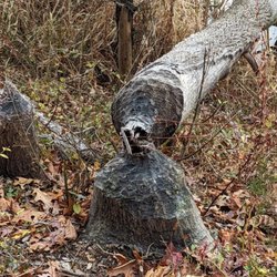
***2 1/2 stars*** There are a lot of people out there who can and do enjoy this park. If you're a birdwatcher, this is a great place to ogle some waterfowl, probably one of the best in the area. Young pups can easily traverse the boardwalks and there's a lot of kid-friendly educational material for them to access along the way, so that's a selling point as well. However, if you're looking for a place to hike, this is one of my least favorite places to do it, and this review is from that specific perspective. I came here on Sunday with my chum and her Wee One for a low-stress 2.9-mile hike. We started in the early afternoon, and it took about 2 1/2 hours. That probably seems inordinately high for the mileage, but it will make sense shortly. Unfortunately, it was cloudy throughout. I've been here once before and to areas of the nearby Great Swamp National Wildlife Refuge a handful of times - it's definitely more enjoyable visually when it's sunny out, especially with so much water nearby to conveniently reflect the sunshine. Alas. Our adventure took us on the Yellow Trail from the eastern side of the Environmental Education Center, veering right multiple times and going by Lily Pad Pond and the East Observation Tower. We then headed toward the boardwalk area via the Wood Duck Loop, traversed the Boondocks Boardwalk and headed back on the Red Trail past the Great Swamp Oak to complete a quasi-circular loop. The absolute worst part of hiking here is that it does not matter when the last rainfall occurred - I have been here when it's been dry for a week and, as was the case this time, when it rained the day before. It's soggy and not a lot of fun to hike in and involves a lot of off-trail improvising through sticker bushes that massively slows you down. And if it rained recently? Forget it. Huge swaths of the path are glorified streams. They've spent a lot of time (and I suspect money) on their boardwalk section, but if they're trying to lure hikers in, that yellow trail really needs some TLC. Maybe you can just import some soil in there so it's a little higher, but it's rough going. Same token, the boardwalk is definitely deteriorating in parts. We saw sections that had recently been repaired, but there are still a lot of decaying/mossy boards out there. I don't recall a point where we were seriously concerned that the boardwalk was going to give out underneath us, but it's heading in that direction. Second worst part of hiking here? No pooches allowed. Very sad, and I'm not sure if that rule is in place because of the terrain or out of an abundance of caution for the creatures who live here. But regardless, I did not have the pleasure of seeing any canines enjoying the fresh air. Additionally, there were no bathroom options when we came. They probably have facilities in the Educational Center but that was closed on Sunday. I definitely remember seeing a port-a-potty off to the side on my prior visit, but it wasn't there this time. One positive though that deserves mention - the trail markings are excellent. I think some of the trails could be better assigned/distributed (there were multiple occasions when the yellow trail would fork, but it would be yellow both ways). We had a specific hiking itinerary but I'm sure that can be confusing for others. I'd just make one of the prongs of the trail fork a different colored trail. But regardless, every intersection was carefully noted and most had very visually appealing signs. I'm not crazy about a lot of the hiking options in this area (mostly because the terrain isn't challenging and there aren't a lot of fun viewpoints), but I'd recommend Jockey Hollow over this. That said, if your idea of a great Sunday is staring at herons, by all means make the trek over here. read more


4 years ago
8 years ago
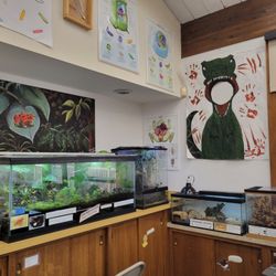
Great environmental education center for adults and kids. Easy, flat trails through wetlands that are well marked, though the maps at the intersections and junctions are badly faded. We enjoyed our time here and would return. read more


4 years ago
7 years ago
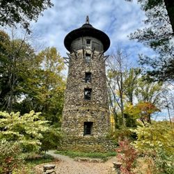
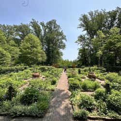
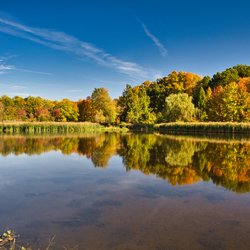
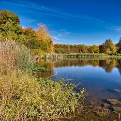
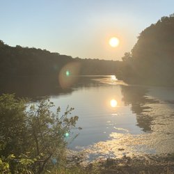
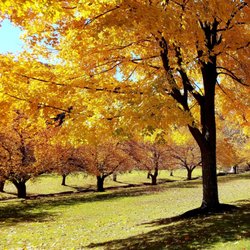
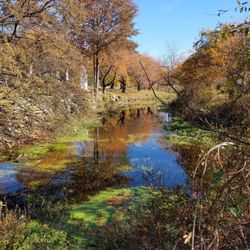
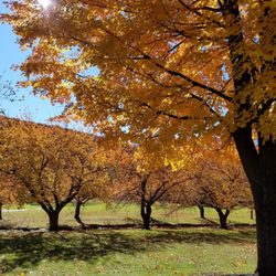
This is a great park near the Raptor Trust and the Great Swamp in Somerset County.It's deceptively large, the trails go back further than you might think.There are lily ponds , a lake(artificial),a board walk through a marsh , a nice meadow and you're next to a river.As for animal life ,I did see a humming bird once.It was a strange sight. I thought it was a big insect at first.Lots of red winged black birds and usually Canada Geese .At certain times deer. Squirrels,chipmunks, swallows and various little creatures.It's a good place to visit and walk .It has a center that occasionally has something interesting in it and a bathroom . read more


8 years ago
More info about Lord Stirling Park
190 Lord Stirling Riad
Bernards, NJ 07920
Directions
(908) 766-2489
Call Now
Hours
Indoor Amenities
Outdoor Amenities
Ask the Community - Lord Stirling Park
You might also consider


Lord Stirling Park - parks - Updated July 2026
Best of Bernards
People found Lord Stirling Park by searching for…
Dog Parks in Bernards, New Jersey
Things to Do in Bernards, New Jersey
Playgrounds in Bernards, New Jersey
Walking Trails in Bernards, New Jersey
Hiking Trails in Bernards, New Jersey
Lakes & Ponds in Bernards, New Jersey
Running Trails in Bernards, New Jersey
Boardwalk in Bernards, New Jersey
Attractions in Bernards, New Jersey
Parks for Kids in Bernards, New Jersey
Dog Friendly Trails in Bernards, New Jersey
Scenic View in Bernards, New Jersey
River Swimming in Bernards, New Jersey
Playgrounds for Kids in Bernards, New Jersey
Scenic Overlook in Bernards, New Jersey
Picnic Spots in Bernards, New Jersey
Photo Spots in Bernards, New Jersey
Places to Take Pictures in Bernards, New Jersey
Lookout Points in Bernards, New Jersey
Stroller Friendly Hikes in Bernards, New Jersey
Running Tracks Open to the Public in Bernards, New Jersey
Browse Nearby
BEST of Bernards, New Jersey Restaurants near Lord Stirling Park
BEST of Bernards, New Jersey Coffee near Lord Stirling Park
BEST of Bernards, New Jersey Things to Do near Lord Stirling Park
BEST of Bernards, New Jersey Breakfast near Lord Stirling Park
BEST of Bernards, New Jersey Bowling near Lord Stirling Park
Browse Brands
Browse Articles
People who viewed Lord Stirling Park also viewed
Washington Valley Park
9 reviews
Speedwell Park
8 reviews
Great Swamp Outdoor Education Center
9 reviews
Great Swamp National Wildlife Refuge
3 reviews
spring lake park
8 reviews
Papaianni Park
7 reviews
Hawk Rise Sanctuary
5 reviews
Harry Dunham Park
6 reviews
Meisel Park
4 reviews
New Jersey Audubon's Scherman Hoffman Wildlife Sanctuary
6 reviews