King Range National Conservation Area Photos


More like King Range National Conservation Area
Recommended Reviews - King Range National Conservation Area
Start your review...

Reviews With Photos

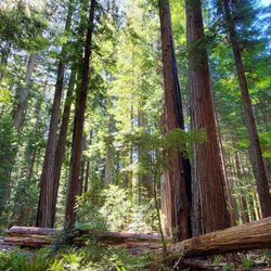
The ruggedness and beauty of California's Lost Coast is unparalled anywhere else in the world, except maybe for parts of Alaska. Perhaps if the west coast of Ireland had trees it could also be this majestic. Hidden on the very southern most end of the Lost Coast is Shady Dell, a grove of unique of redwoods that defies written description. Nicknamed the "Enchanted Forest" pictures barely even do it justice. This is the Chronicle's link to the land purchase article: http://www.sfgate.com/default/article/Shady-Dell-deal-preserves-majestic-redwood-forest-2324634.php These trees are a one of a kind stand of "candelabra redwoods" Shaped by decades of wind, these trees could be straight out of a Harry Potter movie. I could easily see Voldermort's wand chopped from one of these branches. To get there you have to drive six miles in on an old dirt logging road, the trees are on the opposite hillside across the wooden bridge from the huge rock memorial to the 18yo girl who died while drunkenly falling out of the back of a pick-up truck 20 years ago. (I swear, I am not making this up!) Few will ever venture this far, but for those willing to take the trek to the Lost Coast, I promise you won't be disappointed.

We stayed one night at the Wailaki Campground at the southern end of King Range. It was more of a stop along the way on our trip, but the area is beautiful and remote. When we showed up, we were literally the only ones at this first-come first-serve campground. Eventually another couple came but it was completely quiet and remote the night we visited. The road in from the 101 is super windy and narrow, yet the locals tend to fly down the road so be careful. We passed a lot of junkyards on the way in, which gave us an eerie vibe, but the campground was beautiful and we didn't have any issues. A night's stay is only $8, so super affordable and the bathrooms are very basic.

5 Stars for a breathtaking, isolating, and truly nature binding hike. I went with my friend for a long (14mi ish) day hike. Started at Shelter Cove along Black Sands beach & Lost Coast Trail to Buck Creek Trail and looped back around. I love this hike because it appears to have been barely touched by man, and we felt completely alone in King Range (although we passed one group of tired campers on the beach- who kindly warned us of bear tracks they had seen by the trail we were looking for.) I checked tides before hand and was prepared for that. Id read other reviews if you plan on camping, but as for a day trip, I can vouch that the highlights were the views and the solitude of the place. Usual tips - food & water, check tides, etc etc. Im a spontaneous person, and sometimes hasty, so honestly, I wasn't the smartest person about this hike (I planned it last min). We used a print-out map that specifically stated that it should NOT be used as a hiking map... so we couldnt tell how far away we were from other trails, etc. Luckily we found a posted trail map on Saddle Mtn Road which was a little more helpful. Im an avid hiker/runner so the trails were not the hard part, but the altitude change is what wore me out the most. The variety of trees, plants and animals were plentiful and the hike was, simply put, gorgeous. I love the beach and the mountains, so the combination of the two was my dream come true!

Hmmm....I don't know how to say this.....I want to review this place, but by doing so I'm sure I will raise attention to the place: raise people's attention to one of the best places in the world, or quietly stand in the corner and look around nonchalantly.....I'm a yelper, and I must yelp! Ok, the Lost Coast. It has to be one of my favorite places on the planet. I've been going here since 1993. When I was going to school at Humboldt State, I should have went every weekend, but I didn't have a vehicle. Now, I just go whenever I am down there, and everytime I go, I remember how much I miss this place. The Lost Coast (going south via Ferndale toward Petrolia) is a stretch of northern California coastline which is very isolated and somewhat rugged. The single lane rough road sometimes degenerates to only one way of single lane traffic and a dirt road on stretches. This driving sketchiness adds to the flavor of the Lost Coast. **it's not that rough, but the drive can be breath-taking and attention-pulling** There are drives through pine forests, pasture-y hills, very high bluffs (with awesome views of the Pacific), and then long straight stretches where you can almost be splashed by the waves. This is a remote part of the world (and for California--go figure!). Unfortunately, there are stretches fenced and holding cattle--who let that happen? The weather can be iffy, so hope you luck out and get some rain-free hours. I love this place. I've gone for day trips, but I think my favorite thing to do is an overnight hiking-in camping trip. From the parking lot near Petrolia, one can hike down south along the coast, and see groups of huge pelicans glide super-low along the waves, sea lions poking their heads up looking at you, and tons of beautiful scenery. There are a few abandoned structures worth checking out on the hike south, most notably: the Punta Gorda lighthouse. I've actually set up camp near it. Have had some awesome sunsets here. At night you can see fishing trawlers miles out at sea with there night lights ablaze. Be wary of the bluffs above the beach. One time we hiked straight up them (for a good view), and hours/days later, I realized I had poison oak!! Sucked! But that's a small price to pay. Now back to the "real" world and my daydreams of being back on the Lost Coast...with a Lost Coast brew in hand.

I'll second everything that previous reviewers have said about the Lost Coast, and add that there are great trails in the interior of the King Range NCA as well. I recommend the moderate five-mile loop hike from the Lightning trailhead to the summit of King Peak, at 4088 feet the highest mountain in the range, and only about three miles from the beach. The views are absolutely stunning, taking in sections of the coast below and the river valleys and mountains to the north, east, and south. We on the North Coast are truly spoiled for choice when it comes to natural beauty, and the King Range is definitely one of our brightest jewels.

The Lost Coast definitely deserves five stars! It is one of the most beautiful if not the most beautiful parts of California and this is coming from someone who has hiked through the rest of the Redwood Coast, Yosemite, the beaches of Southern California and the mountains of the Sierra. It is a very fitting place to be my 75th Yelp review. My group began the hike on Thursday, April 26th as we drove all the way up from the San Francisco Bay area. Our goal was to walk the entire Lost Coast, starting from Shelter Cove and walking 24 miles in 4 days to the northern end at the Mattole River mouth. We began our hike at Black Sands Beach and walked three miles in and found a campsite a bit above the beach so the high tide would not get us. Our chosen campsite was a bit too sandy for our liking though. We arrived late so set up camp at 10 and watched the moon set. Then a squall suddenly came out of nowhere and for 20 minutes, rain pounded our tents and clothing so we had to put on our rain gear but once we did, the storm stopped! Once all was said done though, it was somewhere around 1am (I did not bother checking my watch,) when we fell asleep. The next morning, we woke up and looked at our tide tables. There are impassable zones so when you hike on the Lost Coast, BRING your tide tables for Shelter Cove and a map that shows where the impassable zones are. There are a few impassable areas along the Lost Coast and you need to use the tide tables and your map so you can safely pass the impassable zones. Also, remember to bring bear canisters too, we did not run into bears on our trip but we did see bear tracks once or twice and a friend who went to the Lost Coast a few years ago woke up to find bear tracks next to her tent so keep your food safe! We then camped at Big Flat which has a few good camping spots that are sheltered by some small wind swept trees but be warned it can get very windy here. April 28th: we then hiked along a trail which followed the ocean to Spanish Flat which is a nice flat area just north of a small cabin. Make sure to camp in the stream area though because camping on the flat means getting battered by wind (and if you are not careful, your tent may blow away which happened to one of our group members and it almost hit the ocean. We raced after it and carried it back. Then we decided to put large rocks on the stakes which was not too hard because there were large rocks everywhere to hold down the tents. Anyway, on April 29th, we arose and hiked further north, keeping a close eye on the tide tables because we were going through an impassable zone that was very rocky. Make sure to rock hop because these rocks are very slippery. Then the rocks finally ended and we approached an abandoned lighthouse. The lighthouse is called Punta Gorda and we climbed up to the top room on a rickety stairway. We got to see the part of the Lost Coast we had just hiked on, a rock filled beach which was fun. Then we sat down there and felt how protected we were from the wind. After the lighthouse though, things became easier as the beach became wider and less rocky. Then we passed the last impassable zone and were fine in terms of tides. What was not fine was the wind which kept blowing. We passed Windy point which was the most windiest part. We felt battered and beat but we continued onward andcamped 2 miles from the parking lot. We found a quiet place in the sand dunes and spent time watching the sun go down. We also noticed how the clouds were beginning to form. The next morning, we saw how cloudy it was and fearing a possible rain shower, we packed up and in 40 minutes, we reached our shuttle van. 15 minutes after we were packed up in it, it began to rain. Phew!!! Overall, it was so exciting to finish our trip and I just love the lost coast so much! It had been my goal for three years to get up here and hike at least part of the coast. Who knew I could hike all of it? It was so beautiful, so unspoiled and I really hope it stays that way. It definitely deserves five stars for its tranquility and beauty.

Grr. Oh Yelp, why dost thou load my photographs backwards? I wanted to tell a story ... Just back from a beautiful weekend on the Humboldt/Mendocino Coast. Back to what appears a rainy day in the Bay Area. In late June. Wtf. This walk was as splendid as the last. Different, as I had a hiking buddy this time, different as I left the water filter on my bed at home and had to beg other hikers for the use of theirs. Different in those respects but similar in many others. Tips: 1. Bring the bear can for the food. I still don't think you need it if you think about what you're doing before you do it but the rangers don't agree and as we saw two this trip and they are serious about the bears you may as well bring it along. I hate bear cans. 2. Time your walk so you can stay at the best campsites. I like Big Flat the best of all. It's about 17 miles in from the northern trailhead, so either: a) start early and walk all the way there in one day, or b) start late, spend the first night at the lighthouse (3 ish miles), and make a more leisurely day of it to the sweet driftwood shelters that will serve for your Big Flat dwelling on day 2. 3. Time the tides. I don't fret too much over them but it pays to have a general sense of when they'll be high. Some spots are tough to traverse at high water. And some of the tough spots at high water are comprised of stones the size of bowling balls that when wet and when you're in a hurry because of sneaker waves can be a real pain to get across. Literally. 4. Watch for the rattlers in the grass; don't tree your food. 5. Pack a little tequila for the gloaming. About 280 miles from Temescal to the mouth of the Mattole (north trailhead). Less to Shelter Cove. You can take two cars and shuttle around (if you have company) or park at Shelter Cove and arrange for a shuttle to take you north (you'll be hiking back to your car at SC). A couple of years ago I paid 50 clams for a solo trip from SC to the put-in. Takes about an hour and a half to get around. The Lost Coast is about as far in miles and time as Yosemite Valley. In all other respects, it's a world apart. We're blessed to live in such a wonderful place. Take it all in. read more


. - Parks Near Me - Whitethorn, California")


. - Parks Near Me - Whitethorn, California")
I went backpacking this Memorial weekend. It was an unforgettable experience. Lost Coast. First time I heard the name, I imagined a very desolated and abandoned coast. I got a picture in my mind the ocean sitting with sadness. I went there and found my image was not so wrong. There were a lot of driftwood on the beach as if it was abandoned by somebody. Scattered woods looked in grief. However, right next to the beach with dead trees, steep hills with lush green reside. What a contrast. The other side is Pacific Ocean. Ocean is powerful and strong. Reflecting the sun, the ocean was very shiny. So beautiful. I was able to see whales, sealions, and sea otters. Beauty and sadness exist on the same page. Actually the naming is from depopulation in 1930. Now many backpackers are attracted by the pretty scenery. In terms of difficulty of backpacking, I would say it is very different from doing in the Eastern Sierra. Hiking on the sandy and rocky beach requires another muscles. Overall, this Memorial Weekend was memorable. read more


The way most hikes in my experience work is that you climb for several miles and get rewarded with grand sweeping views. The Lost Coast is a bit different. It's mostly flat and instead of long climbs rewarded with breathtaking views, it's mostly sand and loose rocks rewarded with solid ground. You know how after being thirsty forever, you understand how delicious water tastes? Well, after walking on sand for 5-6 miles, you understand how delicious solid ground feels beneath your feet. It was quite punishing and for that reason, I don't think I'd come back to the Lost Coast again for the 26 mile hike from Mattole Trailhead to Black Sand Beach. That being said, I'm extremely glad I did the hike. The isolation here - I didn't see any human constructs (road, pier, building) - presents you experiences you will never get again. The feeling of walking alongside the Pacific Ocean for 10+ miles and then sitting down and eating dinner to the sunset with a buddy is indescribable. At one point, we set out at 1 a.m. to avoid the high tides that would come in. What I saw that night I'll never forget. Deers darting back in forth with eyes shining in the dark, and the entire night sky visible to me. EVERY single star as well as the Milky Way. And no moon either. If you're not walking back to where you started (which will probably add 3 days to your trip) you can either bring two cars and transport from end to beginning or hire a local shuttle. Sure the local shuttles are expensive but a) you're supporting the locals and b) Do you really want o drive an extra 4 miles after you hiked a grueling 26 miles? I dearly hope this coast remains "lost" and that no highway or other constructs are created. The only sign of human technology I saw other than camping gear and carved out trails was one airplane and one boat. I'm so glad I came out here. But like I said, walking on sand for that long made me want to tear my own feet off. read more


14 years ago
The ruggedness and beauty of California's Lost Coast is unparalled anywhere else in the world, except maybe for parts of Alaska. Perhaps if the west coast of Ireland had trees it could also be this majestic. Hidden on the very southern most end of the Lost Coast is Shady Dell, a grove of unique of redwoods that defies written description. Nicknamed the "Enchanted Forest" pictures barely even do it justice. This is the Chronicle's link to the land purchase article: http://www.sfgate.com/default/article/Shady-Dell-deal-preserves-majestic-redwood-forest-2324634.php These trees are a one of a kind stand of "candelabra redwoods" Shaped by decades of wind, these trees could be straight out of a Harry Potter movie. I could easily see Voldermort's wand chopped from one of these branches. To get there you have to drive six miles in on an old dirt logging road, the trees are on the opposite hillside across the wooden bridge from the huge rock memorial to the 18yo girl who died while drunkenly falling out of the back of a pick-up truck 20 years ago. (I swear, I am not making this up!) Few will ever venture this far, but for those willing to take the trek to the Lost Coast, I promise you won't be disappointed. read more


10 years ago
We stayed one night at the Wailaki Campground at the southern end of King Range. It was more of a stop along the way on our trip, but the area is beautiful and remote. When we showed up, we were literally the only ones at this first-come first-serve campground. Eventually another couple came but it was completely quiet and remote the night we visited. The road in from the 101 is super windy and narrow, yet the locals tend to fly down the road so be careful. We passed a lot of junkyards on the way in, which gave us an eerie vibe, but the campground was beautiful and we didn't have any issues. A night's stay is only $8, so super affordable and the bathrooms are very basic. read more

5 years ago
14 years ago
5 Stars for a breathtaking, isolating, and truly nature binding hike. I went with my friend for a long (14mi ish) day hike. Started at Shelter Cove along Black Sands beach & Lost Coast Trail to Buck Creek Trail and looped back around. I love this hike because it appears to have been barely touched by man, and we felt completely alone in King Range (although we passed one group of tired campers on the beach- who kindly warned us of bear tracks they had seen by the trail we were looking for.) I checked tides before hand and was prepared for that. Id read other reviews if you plan on camping, but as for a day trip, I can vouch that the highlights were the views and the solitude of the place. Usual tips - food & water, check tides, etc etc. Im a spontaneous person, and sometimes hasty, so honestly, I wasn't the smartest person about this hike (I planned it last min). We used a print-out map that specifically stated that it should NOT be used as a hiking map... so we couldnt tell how far away we were from other trails, etc. Luckily we found a posted trail map on Saddle Mtn Road which was a little more helpful. Im an avid hiker/runner so the trails were not the hard part, but the altitude change is what wore me out the most. The variety of trees, plants and animals were plentiful and the hike was, simply put, gorgeous. I love the beach and the mountains, so the combination of the two was my dream come true! read more


13 years ago
Hmmm....I don't know how to say this.....I want to review this place, but by doing so I'm sure I will raise attention to the place: raise people's attention to one of the best places in the world, or quietly stand in the corner and look around nonchalantly.....I'm a yelper, and I must yelp! Ok, the Lost Coast. It has to be one of my favorite places on the planet. I've been going here since 1993. When I was going to school at Humboldt State, I should have went every weekend, but I didn't have a vehicle. Now, I just go whenever I am down there, and everytime I go, I remember how much I miss this place. The Lost Coast (going south via Ferndale toward Petrolia) is a stretch of northern California coastline which is very isolated and somewhat rugged. The single lane rough road sometimes degenerates to only one way of single lane traffic and a dirt road on stretches. This driving sketchiness adds to the flavor of the Lost Coast. **it's not that rough, but the drive can be breath-taking and attention-pulling** There are drives through pine forests, pasture-y hills, very high bluffs (with awesome views of the Pacific), and then long straight stretches where you can almost be splashed by the waves. This is a remote part of the world (and for California--go figure!). Unfortunately, there are stretches fenced and holding cattle--who let that happen? The weather can be iffy, so hope you luck out and get some rain-free hours. I love this place. I've gone for day trips, but I think my favorite thing to do is an overnight hiking-in camping trip. From the parking lot near Petrolia, one can hike down south along the coast, and see groups of huge pelicans glide super-low along the waves, sea lions poking their heads up looking at you, and tons of beautiful scenery. There are a few abandoned structures worth checking out on the hike south, most notably: the Punta Gorda lighthouse. I've actually set up camp near it. Have had some awesome sunsets here. At night you can see fishing trawlers miles out at sea with there night lights ablaze. Be wary of the bluffs above the beach. One time we hiked straight up them (for a good view), and hours/days later, I realized I had poison oak!! Sucked! But that's a small price to pay. Now back to the "real" world and my daydreams of being back on the Lost Coast...with a Lost Coast brew in hand. read more


17 years ago
I'll second everything that previous reviewers have said about the Lost Coast, and add that there are great trails in the interior of the King Range NCA as well. I recommend the moderate five-mile loop hike from the Lightning trailhead to the summit of King Peak, at 4088 feet the highest mountain in the range, and only about three miles from the beach. The views are absolutely stunning, taking in sections of the coast below and the river valleys and mountains to the north, east, and south. We on the North Coast are truly spoiled for choice when it comes to natural beauty, and the King Range is definitely one of our brightest jewels. read more


13 years ago
The Lost Coast definitely deserves five stars! It is one of the most beautiful if not the most beautiful parts of California and this is coming from someone who has hiked through the rest of the Redwood Coast, Yosemite, the beaches of Southern California and the mountains of the Sierra. It is a very fitting place to be my 75th Yelp review. My group began the hike on Thursday, April 26th as we drove all the way up from the San Francisco Bay area. Our goal was to walk the entire Lost Coast, starting from Shelter Cove and walking 24 miles in 4 days to the northern end at the Mattole River mouth. We began our hike at Black Sands Beach and walked three miles in and found a campsite a bit above the beach so the high tide would not get us. Our chosen campsite was a bit too sandy for our liking though. We arrived late so set up camp at 10 and watched the moon set. Then a squall suddenly came out of nowhere and for 20 minutes, rain pounded our tents and clothing so we had to put on our rain gear but once we did, the storm stopped! Once all was said done though, it was somewhere around 1am (I did not bother checking my watch,) when we fell asleep. The next morning, we woke up and looked at our tide tables. There are impassable zones so when you hike on the Lost Coast, BRING your tide tables for Shelter Cove and a map that shows where the impassable zones are. There are a few impassable areas along the Lost Coast and you need to use the tide tables and your map so you can safely pass the impassable zones. Also, remember to bring bear canisters too, we did not run into bears on our trip but we did see bear tracks once or twice and a friend who went to the Lost Coast a few years ago woke up to find bear tracks next to her tent so keep your food safe! We then camped at Big Flat which has a few good camping spots that are sheltered by some small wind swept trees but be warned it can get very windy here. April 28th: we then hiked along a trail which followed the ocean to Spanish Flat which is a nice flat area just north of a small cabin. Make sure to camp in the stream area though because camping on the flat means getting battered by wind (and if you are not careful, your tent may blow away which happened to one of our group members and it almost hit the ocean. We raced after it and carried it back. Then we decided to put large rocks on the stakes which was not too hard because there were large rocks everywhere to hold down the tents. Anyway, on April 29th, we arose and hiked further north, keeping a close eye on the tide tables because we were going through an impassable zone that was very rocky. Make sure to rock hop because these rocks are very slippery. Then the rocks finally ended and we approached an abandoned lighthouse. The lighthouse is called Punta Gorda and we climbed up to the top room on a rickety stairway. We got to see the part of the Lost Coast we had just hiked on, a rock filled beach which was fun. Then we sat down there and felt how protected we were from the wind. After the lighthouse though, things became easier as the beach became wider and less rocky. Then we passed the last impassable zone and were fine in terms of tides. What was not fine was the wind which kept blowing. We passed Windy point which was the most windiest part. We felt battered and beat but we continued onward andcamped 2 miles from the parking lot. We found a quiet place in the sand dunes and spent time watching the sun go down. We also noticed how the clouds were beginning to form. The next morning, we saw how cloudy it was and fearing a possible rain shower, we packed up and in 40 minutes, we reached our shuttle van. 15 minutes after we were packed up in it, it began to rain. Phew!!! Overall, it was so exciting to finish our trip and I just love the lost coast so much! It had been my goal for three years to get up here and hike at least part of the coast. Who knew I could hike all of it? It was so beautiful, so unspoiled and I really hope it stays that way. It definitely deserves five stars for its tranquility and beauty. read more


12 years ago
17 years ago
10 years ago
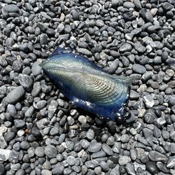
Just an awesome experience from beginning to end. I did an 8 mile and a 10 mile hike - two separate days - and saw a total of three people! And I think that says all you need to know about how isolated this place is. If you want to get away from people, and see a beautiful unspoiled coastline, and a black pebble sand beach - this is the place. read more

17 years ago
15 years ago
More info about King Range National Conservation Area
Ask the Community - King Range National Conservation Area
Review Highlights - King Range National Conservation Area


Why does Yelp recommend reviews?
1 review that is not currently recommended
The reviews below are not factored into the business's overall star rating.
7 months ago
King Range National Conservation Area - parks - Updated July 2026
Best of Whitethorn
People found King Range National Conservation Area by searching for…
Things to Do in Whitethorn, CA
Hiking Trails in Whitethorn, CA
Redwood Trees in Whitethorn, CA
Watch Sunset in Whitethorn, CA
River Swimming in Whitethorn, CA
Waterfall Hike in Whitethorn, CA
Dog Friendly Trails in Whitethorn, CA
Fishing Spots in Whitethorn, CA
Places to Swim in Whitethorn, CA
Camping Sites in Whitethorn, CA
National Parks in Whitethorn, CA
Beach Bonfire in Whitethorn, CA
Beach Camping in Whitethorn, CA
Abandoned Places in Whitethorn, CA
Browse Brands
Browse Articles
People who viewed King Range National Conservation Area also viewed
Humboldt Redwoods State Park
132 reviews
Avenue of the Giants
191 reviews
Sinkyone Wilderness State Park
5 reviews
Mal Coombs Park
2 reviews
Richardson Grove State Park
62 reviews
Black Sands Beach
23 reviews
Standish-Hickey State Recreation Area
53 reviews
Seal Rock
1 review
Drive-Thru Tree
206 reviews
Abalone Point
1 review