Jenner Headlands Preserve Photos


You might also consider
More like Jenner Headlands Preserve
Recommended Reviews - Jenner Headlands Preserve
Start your review...

Reviews With Photos


One of the prettiest hikes in the area! Such a gorgeous view the entire hike (wildflower loop). I've not taken the trails up to Pole Mountain but I can tell you the sea to sky and raptor ridge trails are spectacular. The views on this hike are stunning including ocean views (duh) all the way along the coastline to the rivers end. For the loop I've done you have nothing but beautiful views the entire time. The loop I do is about 4.5 miles, and if you go up the sea to sky trail you hit the climb first and cruise downhill the rest of the hike. The last few times we've been it's mucky out there so be prepared for some muddy fun. Overall well maintained trails with cattle gates to keep cows where they belong along the trails. If anyone has ever hiked Taylor Mountain these trails can offer the same bovine interaction depending on where they feel like roaming. Keeps it interesting for sure. Great parking lot, maps, and bathrooms. Really well thought out park. Overflow parking available across the highway as needed. Not too steep, nice steady rolling incline with views for days. Just the best!

Dog friendly trails with gorgeous views! I cannot tell you how hard it is to "discover" dog friendly trails in Sonoma county, but Jenner Headlands is everything I've been looking for. Brought my Aussiedoodle for a 8 mile hike on the Sea to Sky trail. The path takes you through cow grazing areas, so be mindful of cow pies and don't let your dogs off leash! It was pretty foggy when we were here, so no coastal panoramics nor whale sightings, but the temperature was perfect for our extra fluffy dog. The parking lot is paved and very accessible. The facilities ate clean and about a 2 minutes walk from the parking lot. Would definitely return!
Simply stunning views from here! One has several options for hikes- depending on how much time and stamina you have. We did an out & back to the barn at the top off a mountain and enjoyed the scenery along the way immensely. Next time I want to choose the hike to Pole Mountain with a much earlier start. Parking can be tough here. But, oh so worth it.

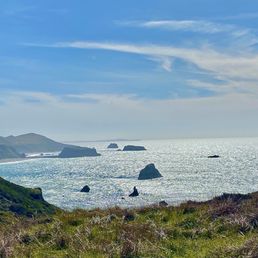
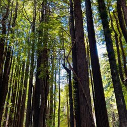
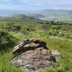
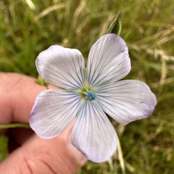
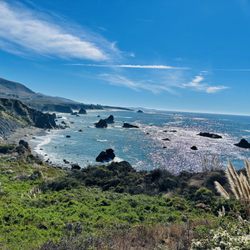
Far up the Sonoma Coast, just past where the Russian River hits the coast, you will arrive at one of the newest parks in the North Bay-the Jenner Headlands Preserve. The Sonoma Land Trust oversees this preserve and have some information as well as a map on their website. This is a beautiful swath of land east of Highway 1 that is now open to the public with over 30 miles of hiking trails, a small picnic area near the parking lot and some of the most scenic hiking views in Sonoma County. From the East Bay it took about 2 hours, but it's a pretty drive so I was able to enjoy the journey en route to the destination. The lot holds about 30 cars and I only saw a handful of spots along Highway 1 that seemed safe to park at. I was lucky to snag a spot in the lot, but it was pretty crowded on a Saturday afternoon-word is getting out! The Sonoma Land Trust has a pretty easy to read map online and I had planned out my route in advance. I decided on Raptor Ridge with a detour to the Wildflower loop and then completed Raptor Ridge, connecting with the Sea to Sky Trail that looped back down to the parking lot. That ended up being 5 miles and gave me a good intro to the park. There are trails that go further up and back, including a route that goes up to Pole Mountain (7..5 miles one way and an all day excursion, most likely.) Raptor Ridge was a narrow trail winding gently up through grassland and full of wildflowers this time of year. Although it was about 2 miles uphill the grade was moderate and the views pay off even when you're not far up. Turning around I had amazing views of the coast and looking ahead beautiful vistas of the still green hills of the Headlands. Reaching a barn, with picnic tables for resting, there was a sign pointing to the Wildflower Loop. It was about a .75 mile detour that paid off with an array of wildflowers (go figure-on a trail named Wildflower Loop!) After that I backtracked to finish Raptor Ridge which opened up to a wider gravel trail. Once it ended, you connect with the Sea to Sky trail, where if you go right you'll go up higher in to the preserve, but go left and that will bring you back to the lot. I opted to finish the loop and go down. The Sea to Sky trail going down to the parking lot has plenty of vistas of the Pacific and more rolling hills. This route had a wider trail and some encounters with friendly grazing cattle. The trails are well maintained and well signed. It's muddy in a few spots from recent rains and has some areas that are rocky with some lose rocks. Definitely wear sturdy shoes and dress for a variety of weather. It was cold and windy nearer the coast and warmer and sunny up the hills. The Sonoma Land Trust did an outstanding job getting this preserve ready for the public-and best of all it's free! They do have a box for donations, so considering dropping in a few dollars to support this scenic new hiking wonderland on the Sonoma Coast.

2 months ago
Another fabulous Sonoma Coast hike. One of our favorite day trips. Anytime is beautiful to visit this hiking destination but we love going in but May! It is the perfect time to soak in vibrant wildflowers and lush green landscapes. We love taking Plumette, our Schnoodle. She loves sniffaring here. Pups must be on Leash. Leave no trace. read more


Dog-friendly hiking?! Sign us up! What an absolutely beautiful preserve! The parking lot was full on Sunday midday so we had to backtrack along the road to an auxiliary pullout parking area. Next time we'll drop off one human and the pups before moving the car as it was sketchy walking our pups on Rt 1. There's a nice Info Center at the trailhead, with signage and maps - both posted and printed copies to take. Bathrooms are just a short walk down the trail. There are various trail options, with I think up to 15 miles if you're up for the challenge. We planned to hike ~4 miles but the steep trail was in the direct sun and we all started feeling it. I don't think there's any water on the trail, so bring more than you think you need. We hiked ~1.5 miles up and our pups were getting a bit too warm so turned it around. Not mad about it as we enjoyed stunning ocean views on the way down/back. We all still enjoyed a workout and some peaceful time out in nature. Cows live on the preserve so expect to see cow pies/dung along the path. We didn't see any upclose, but there are warning signs at the trailhead advising you what to do. Despite the full parking lot, the trail wasn't crowded. We can't wait to return! read more


One of the prettiest hikes in the area! Such a gorgeous view the entire hike (wildflower loop). I've not taken the trails up to Pole Mountain but I can tell you the sea to sky and raptor ridge trails are spectacular. The views on this hike are stunning including ocean views (duh) all the way along the coastline to the rivers end. For the loop I've done you have nothing but beautiful views the entire time. The loop I do is about 4.5 miles, and if you go up the sea to sky trail you hit the climb first and cruise downhill the rest of the hike. The last few times we've been it's mucky out there so be prepared for some muddy fun. Overall well maintained trails with cattle gates to keep cows where they belong along the trails. If anyone has ever hiked Taylor Mountain these trails can offer the same bovine interaction depending on where they feel like roaming. Keeps it interesting for sure. Great parking lot, maps, and bathrooms. Really well thought out park. Overflow parking available across the highway as needed. Not too steep, nice steady rolling incline with views for days. Just the best! read more


4 years ago
Dog friendly trails with gorgeous views! I cannot tell you how hard it is to "discover" dog friendly trails in Sonoma county, but Jenner Headlands is everything I've been looking for. Brought my Aussiedoodle for a 8 mile hike on the Sea to Sky trail. The path takes you through cow grazing areas, so be mindful of cow pies and don't let your dogs off leash! It was pretty foggy when we were here, so no coastal panoramics nor whale sightings, but the temperature was perfect for our extra fluffy dog. The parking lot is paved and very accessible. The facilities ate clean and about a 2 minutes walk from the parking lot. Would definitely return! read more


2 years ago
Simply stunning views from here! One has several options for hikes- depending on how much time and stamina you have. We did an out & back to the barn at the top off a mountain and enjoyed the scenery along the way immensely. Next time I want to choose the hike to Pole Mountain with a much earlier start. Parking can be tough here. But, oh so worth it. read more


7 years ago
Far up the Sonoma Coast, just past where the Russian River hits the coast, you will arrive at one of the newest parks in the North Bay-the Jenner Headlands Preserve. The Sonoma Land Trust oversees this preserve and have some information as well as a map on their website. This is a beautiful swath of land east of Highway 1 that is now open to the public with over 30 miles of hiking trails, a small picnic area near the parking lot and some of the most scenic hiking views in Sonoma County. From the East Bay it took about 2 hours, but it's a pretty drive so I was able to enjoy the journey en route to the destination. The lot holds about 30 cars and I only saw a handful of spots along Highway 1 that seemed safe to park at. I was lucky to snag a spot in the lot, but it was pretty crowded on a Saturday afternoon-word is getting out! The Sonoma Land Trust has a pretty easy to read map online and I had planned out my route in advance. I decided on Raptor Ridge with a detour to the Wildflower loop and then completed Raptor Ridge, connecting with the Sea to Sky Trail that looped back down to the parking lot. That ended up being 5 miles and gave me a good intro to the park. There are trails that go further up and back, including a route that goes up to Pole Mountain (7..5 miles one way and an all day excursion, most likely.) Raptor Ridge was a narrow trail winding gently up through grassland and full of wildflowers this time of year. Although it was about 2 miles uphill the grade was moderate and the views pay off even when you're not far up. Turning around I had amazing views of the coast and looking ahead beautiful vistas of the still green hills of the Headlands. Reaching a barn, with picnic tables for resting, there was a sign pointing to the Wildflower Loop. It was about a .75 mile detour that paid off with an array of wildflowers (go figure-on a trail named Wildflower Loop!) After that I backtracked to finish Raptor Ridge which opened up to a wider gravel trail. Once it ended, you connect with the Sea to Sky trail, where if you go right you'll go up higher in to the preserve, but go left and that will bring you back to the lot. I opted to finish the loop and go down. The Sea to Sky trail going down to the parking lot has plenty of vistas of the Pacific and more rolling hills. This route had a wider trail and some encounters with friendly grazing cattle. The trails are well maintained and well signed. It's muddy in a few spots from recent rains and has some areas that are rocky with some lose rocks. Definitely wear sturdy shoes and dress for a variety of weather. It was cold and windy nearer the coast and warmer and sunny up the hills. The Sonoma Land Trust did an outstanding job getting this preserve ready for the public-and best of all it's free! They do have a box for donations, so considering dropping in a few dollars to support this scenic new hiking wonderland on the Sonoma Coast. read more


Beautiful day hiking the coast. We hiked raptor ridge. It was breathtaking views, tons of cows and lots of birds. The hike was strenuous in the first 30 minutes than eased out along the way. Plan for at least 4 hours if you are a slow hiker like me. The parking lot gate closes at sunset so make sure if you are parked there you give yourself enough time to hike and leave by sunset. If you stay passed sunset I would recommend parking on the street which is available as well. Our lab loved the hike! He can't do extremely strenuous hikes but this was perfect for him! We saw some humpback whales spouting from the top of the mountain! There is a telescope for bird and whale watching! It is a gorgeous hike. I can't wait to return! read more


3 years ago
7 years ago
More info about Jenner Headlands Preserve
12001 CA-1
Jenner, CA 95450
Directions
(909) 797-8507
Call Now
Hours
Outdoor Amenities
From the Business
Ask the Community - Jenner Headlands Preserve
Review Highlights - Jenner Headlands Preserve
You might also consider


Why does Yelp recommend reviews?
1 review that is not currently recommended
The reviews below are not factored into the business's overall star rating.
3 years ago
Jenner Headlands Preserve - hiking - Updated July 2026
Best of Jenner
People found Jenner Headlands Preserve by searching for…
Trending Searches in Jenner, CA
Boat Rental near Jenner Headlands Preserve
Cliff Jumping near Jenner Headlands Preserve
Day Trips near Jenner Headlands Preserve
Dog Friendly Beaches near Jenner Headlands Preserve
Fruit Picking near Jenner Headlands Preserve
Jet Ski Rental near Jenner Headlands Preserve
Kayak Rental near Jenner Headlands Preserve
Off Road Trails near Jenner Headlands Preserve
Parasailing near Jenner Headlands Preserve
Picnic Spots near Jenner Headlands Preserve
Pool Day Pass near Jenner Headlands Preserve
Public Shower near Jenner Headlands Preserve
River Swimming near Jenner Headlands Preserve
River Tubing near Jenner Headlands Preserve
Running Trails near Jenner Headlands Preserve
Splash Pad near Jenner Headlands Preserve
Sunrise View near Jenner Headlands Preserve
Swimming Holes near Jenner Headlands Preserve
Swimming Lakes near Jenner Headlands Preserve
Watch Sunset near Jenner Headlands Preserve
Browse Articles
Browse Nearby
BEST of Jenner, California Restaurants near Jenner Headlands Preserve
BEST of Jenner, California Things to Do near Jenner Headlands Preserve
BEST of Jenner, California Coffee near Jenner Headlands Preserve
BEST of Jenner, California Parks near Jenner Headlands Preserve
BEST of Jenner, California Beaches near Jenner Headlands Preserve
BEST of Jenner, California Campgrounds near Jenner Headlands Preserve
BEST of Jenner, California Breakfast near Jenner Headlands Preserve
Browse Brands
Related Searches in Jenner, CA
Affordable Kayak Rental Services in Jenner, California
Best Fishing Locations and Guides in Jenner, California
Best Places for Horseback Riding in Jenner, California
Best Places for Stunning Views in Jenner, California
Best Spots for Star Gazing in Jenner, California
Check Out Off Road Trails in Jenner, California
Discover Dog Friendly Trails to Explore in Jenner, California
Discover Popular Photo Spots in Jenner, California
Discover Scenic Mountain Bike Trails Near Jenner, California
Discover a Hiking Trail in Jenner, California
Discover the Best Night Hike Trails in Jenner, California
Dog-Friendly Hikes With Dogs in Jenner, California
Enjoy Camping Adventures Around Jenner, California
Enjoy Exciting Mountain Biking Adventures in Jenner, California
Enjoy Kayaking Adventures in Jenner, California
Enjoy River Tubing Adventures in Jenner, California
Enjoy Tent Camping Spots Around Jenner, California
Enjoy a Beautiful Waterfall Hike in Jenner, California
Enjoy the Best Tubing Experiences in Jenner, California
Enjoy the Best Walking Trails in Jenner, California
Exciting Cliff Jumping Spots in Jenner, California
Explore Beautiful Parks and Green Spaces in Jenner, California
Explore Easy Hikes Perfect for All in Jenner, California
Explore Fun Activities to Do in Jenner, California
Explore Popular Campgrounds Near Jenner, California
Explore Popular RV Parks Around Jenner, California
Explore Popular View Points Around Jenner, California
Explore Secret Spots Worth Visiting in Jenner, California
Explore Top Dog Parks in Jenner, California Near You
Explore Top Water Parks in Jenner, California Today
Explore the Best Beach Spots in Jenner, California
Explore the Best Swimming Holes Around Jenner, California
Explore the Best Trail Options in Jenner, California
Family Friendly Hiking With Kids in Jenner, California
Find the Best Scenic View Locations in Jenner, California
Hiking Trails With Waterfalls in Jenner, California
Off Leash Dog Hiking Trails in Jenner, California
Plan a Scenic Drive Route Near Jenner, California
Popular Fishing Spots to Explore in Jenner, California
Popular Outdoor Activities to Try in Jenner, California
Popular Things to Do in Jenner, California
Safe River Swimming Areas in Jenner, California
Safe and Fun Parks for Kids in Jenner, California
Top Climbing Spots and Gyms in Jenner, California
Top Paddleboarding Activities in Jenner, California
Top Running Trails to Explore in Jenner, California
Top Swimming Lakes to Enjoy in Jenner, California
Top Swimming Spots and Pools in Jenner, California
People who viewed Jenner Headlands Preserve also viewed
Sonoma Coast State Park
58 reviews
Monte Rio Redwoods Trailhead
3 reviews
Sonoma Coast State Beach
148 reviews
Doran Regional Park
162 reviews
Salt Point State Park
115 reviews
Tomales Bluff
3 reviews
Islands In The Sky Trailhead
1 review
Willow Creek Road Trail
3 reviews
Stillwater Cove Regional Park
36 reviews
Tomales Point
2 reviews