Harwinton Historical Marker Photos


More like Harwinton Historical Marker
Recommended Reviews - Harwinton Historical Marker
Start your review...

The Harwinton marker is located on a small green on a ridiculous curve on Route 4, across from the Congregational church. Do not turn left to get out; yes it may be the direction you want to go in, but by the time you get a gap you could have found a better way by turning right or using a back road. The marker itself is well painted, with a cutesy mile direction sign for other towns nearby. A quick hit on the town signs of Connecticut tour! read more


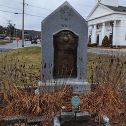
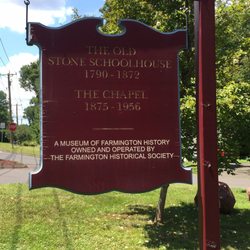
Located on a teeny-tiny parcel of a green on Route 4, the Harwinton Historical Marker stands at the intersection of Litchfield Road and South Road. It's a 2-sided marker with the same text on both sides describing the origin and early history of the town. The text reads: Harwinton The town was settled in 1731, named in 1732 from Harry(tford) and Win(dsor), and became incorporated in October, 1737. Located on the Hartford-Litchfield Turnpike, Harwinton was primarily an agricultural community with many part-time industries carried on in conjunction with farming. Items produced included bricks, tinware, pitchforks, hats, cutlery, whetstones, barrels, and clocks by Hopkins and Alfred, Orson Barber, and Sheldon Osborne. Lead Mine Brook and its tributaries provided water power for many of the early industries. Construction of the first church began in 1740 and the first school was established in 1741. In the 1800's the town boasted two academies and two boarding schools. For many years there were twelve school districts throughout the town. One-room schoolhouses were in use until 1948. Erected by the Town of Harwinton and the Connecticut Historical Commission 1976 The marker is in pretty good shape, with crisp white lettering and good color on the blue background. read more
More info about Harwinton Historical Marker


Harwinton Historical Marker - landmarks - Updated May 2026
Best of Harwinton
People found Harwinton Historical Marker by searching for…
Browse Nearby
BEST of Harwinton, Connecticut Restaurants near Harwinton Historical Marker
BEST of Harwinton, Connecticut Things to Do near Harwinton Historical Marker
BEST of Harwinton, Connecticut Parks near Harwinton Historical Marker
BEST of Harwinton, Connecticut Coffee near Harwinton Historical Marker
BEST of Harwinton, Connecticut Hiking near Harwinton Historical Marker
BEST of Harwinton, Connecticut Breakfast near Harwinton Historical Marker
BEST of Harwinton, Connecticut Campgrounds near Harwinton Historical Marker
BEST of Harwinton, Connecticut Hotels near Harwinton Historical Marker
Browse Brands
Browse Articles
People who viewed Harwinton Historical Marker also viewed
Simsbury Historical Marker
2 reviews
East Windsor Historical Marker
2 reviews
Winchester Center Historical Marker
1 review
Great River Park
5 reviews
Watertown
1 review
Enfield Veterans Monument
2 reviews
Thomaston Historical Marker
1 review
Bond Pond
1 review
Wethersfield
1 review
East Granby Historical Marker
2 reviews