George LeStrange Preserve Photos


You might also consider
More like George LeStrange Preserve
Recommended Reviews - George LeStrange Preserve
Start your review...

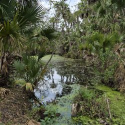
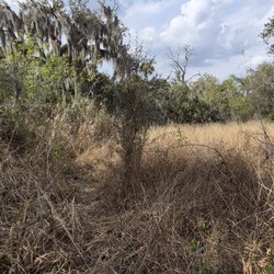
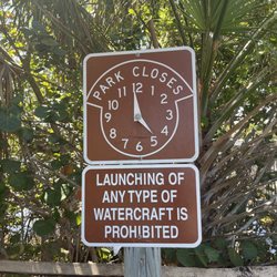
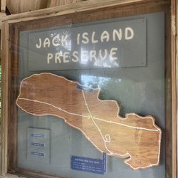
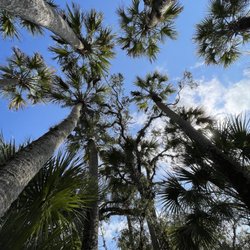
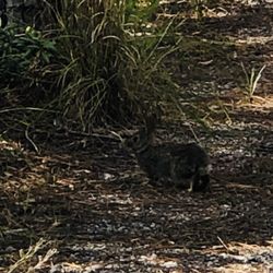
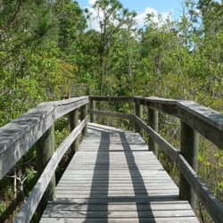
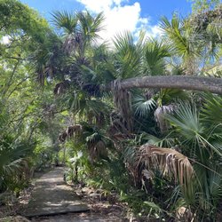
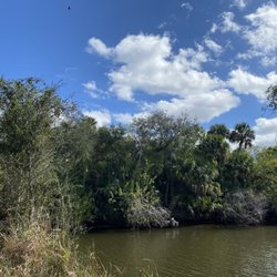
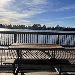
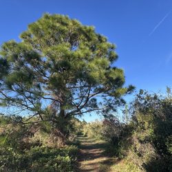
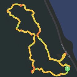
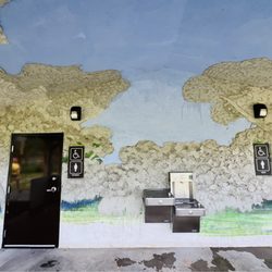
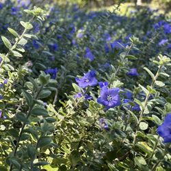
Opened in 2008, George Lestrange Preserve is named for Mr. George E. Lestrange (1912-1962) who was an avid fisherman and nature lover. He used to own the land and his family sold it to the county. This site will connect several miles of proposed trail along Ten Mile Creek and the North Fork of the St. Lucie River. The 94 acre preserve is located at the end of an abandoned neighborhood building project, It has a 37 acre lake that was formed from an old sand mine. The area was restored by taking out exotic plants and replacing them with hundreds of slash pines and some palmetto. The lake has steep slopes and possible alligators so no wading or swimming is allowed. Boaters can launch canoes, kayaks, and boats with electric motors. If you are fishing the lake is catch and release only. Around the lake is a one mile hiking trail and there is at the north end of the preserve there is an additional one mile looping interpretive trail through makes a loop through pine flatwoods, palm hammocks, and floodplain forest. The preserve is home to ospreys and bald eagles. On my visit I saw rabbits, gopher tortoises, and a peacock. If you love nature and wildlife this is the perfect spot to feel removed from the stress of everyday life and experience the way Florida used to look. read more


9 years ago
More info about George LeStrange Preserve
4911 Ralls Rd
Fort Pierce, FL 34981
Directions
(772) 462-2526
Call Now
Hours
Outdoor Amenities


George LeStrange Preserve - hiking - Updated June 2026
Best of Fort Pierce
People found George LeStrange Preserve by searching for…
Abandoned Buildings in Fort Pierce, Florida
Things to Do With Kids in Fort Pierce, Florida
Free Things to Do in Fort Pierce, Florida
Fishing Lake in Fort Pierce, Florida
Walking Trails in Fort Pierce, Florida
Natural Hot Springs in Fort Pierce, Florida
Swimming Lakes in Fort Pierce, Florida
Hiking Trails in Fort Pierce, Florida
Secluded Spots in Fort Pierce, Florida
Waterfalls in Fort Pierce, Florida
Running Trails in Fort Pierce, Florida
River Swimming in Fort Pierce, Florida
Off Road Trails in Fort Pierce, Florida
Places to Take Pictures in Fort Pierce, Florida
Things to Do Alone in Fort Pierce, Florida
Nature Walks in Fort Pierce, Florida
Fun Things to Do on a Friday Night in Fort Pierce, Florida
Nature Preserve in Fort Pierce, Florida
Fishing in Fort Pierce, Florida
Urban Exploration in Fort Pierce, Florida
Abandoned Places in Fort Pierce, Florida
Trending Searches in Fort Pierce, FL
Black Owned Nail Salons near George LeStrange Preserve
Boat Rental near George LeStrange Preserve
Day Trips near George LeStrange Preserve
Dog Friendly Trails near George LeStrange Preserve
Fireworks near George LeStrange Preserve
Fishing Spots near George LeStrange Preserve
Jet Ski Rental near George LeStrange Preserve
Kayak Rental near George LeStrange Preserve
Lakes & Ponds near George LeStrange Preserve
Outdoor Activities near George LeStrange Preserve
Places To Walk Around near George LeStrange Preserve
Public Pools near George LeStrange Preserve
Public Shower near George LeStrange Preserve
River Swimming near George LeStrange Preserve
Scenic Night View near George LeStrange Preserve
Scenic Overlook near George LeStrange Preserve
Secluded Spots near George LeStrange Preserve
Soccer Store near George LeStrange Preserve
Splash Pad near George LeStrange Preserve
Strawberry Picking near George LeStrange Preserve
Sunrise View near George LeStrange Preserve
Swimming Holes near George LeStrange Preserve
Swimming Lakes near George LeStrange Preserve
Watch Sunset near George LeStrange Preserve
Browse Articles
Browse Nearby
BEST of Fort Pierce, Florida Coffee near George LeStrange Preserve
BEST of Fort Pierce, Florida Restaurants near George LeStrange Preserve
BEST of Fort Pierce, Florida Things to Do near George LeStrange Preserve
BEST of Fort Pierce, Florida Parks near George LeStrange Preserve
BEST of Fort Pierce, Florida Breakfast near George LeStrange Preserve
BEST of Fort Pierce, Florida Shopping near George LeStrange Preserve
BEST of Fort Pierce, Florida Campgrounds near George LeStrange Preserve
Browse Brands
Related Searches in Fort Pierce, FL
Affordable Kayak Rental Services in Fort Pierce, Florida
Best Fishing Locations and Guides in Fort Pierce, Florida
Best Places for Horseback Riding in Fort Pierce, Florida
Check Out Off Road Trails in Fort Pierce, Florida
Discover Dog Friendly Trails to Explore in Fort Pierce, Florida
Discover Scenic Mountain Bike Trails Near Fort Pierce, Florida
Discover Top Boat Tours in Fort Pierce, Florida for All Ages
Discover Top State Parks to Visit in Fort Pierce, Florida
Discover Walking Parks in Fort Pierce, Florida Near You
Discover a Hiking Trail in Fort Pierce, Florida
Discover the Best Night Hike Trails in Fort Pierce, Florida
Enjoy Exciting Mountain Biking Adventures in Fort Pierce, Florida
Enjoy Kayaking Adventures in Fort Pierce, Florida
Enjoy Tent Camping Spots Around Fort Pierce, Florida
Enjoy Water Activities and Fun in Fort Pierce, Florida
Enjoy the Best Tubing Experiences in Fort Pierce, Florida
Enjoy the Best Walking Trails in Fort Pierce, Florida
Explore Beautiful Parks and Green Spaces in Fort Pierce, Florida
Explore Bike Rentals Throughout Fort Pierce, Florida
Explore Easy Hikes Perfect for All in Fort Pierce, Florida
Explore Fun Activities to Do in Fort Pierce, Florida
Explore Nature Spots Around Fort Pierce, Florida
Explore Popular Campgrounds Near Fort Pierce, Florida
Explore Popular Scenic Overlook Points in Fort Pierce, Florida
Explore Top Dog Parks in Fort Pierce, Florida Near You
Explore the Best Beach Spots in Fort Pierce, Florida
Explore the Best Boating Spots in Fort Pierce, Florida
Explore the Best Swimming Holes Around Fort Pierce, Florida
Family Friendly Hiking With Kids in Fort Pierce, Florida
Find Beautiful Views in Fort Pierce, Florida
Find Cozy Camping Cabins in Fort Pierce, Florida
Find Parks and Recreation Activities in Fort Pierce, Florida
Find Popular Ziplining Spots Around Fort Pierce, Florida
Find the Best Parks for Picnics in Fort Pierce, Florida
Find the Best Playgrounds to Visit in Fort Pierce, Florida
Find the Best Scenic View Locations in Fort Pierce, Florida
Plan a Scenic Drive Route Near Fort Pierce, Florida
Popular Fishing Spots to Explore in Fort Pierce, Florida
Popular Outdoor Activities to Try in Fort Pierce, Florida
Popular Picnic Spots to Visit in Fort Pierce, Florida
Popular Things to Do in Fort Pierce, Florida
Safe River Swimming Areas in Fort Pierce, Florida
Safe and Fun Parks for Kids in Fort Pierce, Florida
Top Climbing Spots and Gyms in Fort Pierce, Florida
Top Paddleboarding Activities in Fort Pierce, Florida
Top Places for Snorkeling in Fort Pierce, Florida
Top Running Trails to Explore in Fort Pierce, Florida
Top Swimming Lakes to Enjoy in Fort Pierce, Florida
People who viewed George LeStrange Preserve also viewed
Richard E Becker Preserve
2 reviews
Sweetwater Hammock Preserve
2 reviews
Delaplane Preserve
2 reviews
Ten Mile Creek Preserve
2 reviews
Taylor Creek Stormwater Treatment Area
3 reviews
Paleo Hammock Preserve
3 reviews
Queen’s Island Preserve
1 review
Twin Rivers Park
2 reviews
South Causeway Park
2 reviews
Spruce Bluff Preserve
5 reviews