Champlin Glacier Park Photos


You might also consider
More like Champlin Glacier Park
Recommended Reviews - Champlin Glacier Park
Start your review...

15 years ago
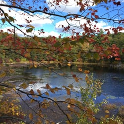
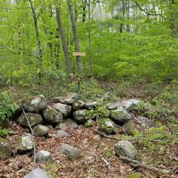
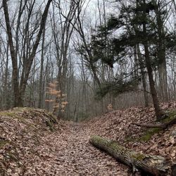
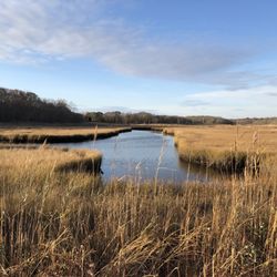
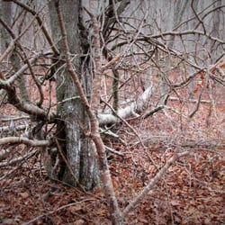
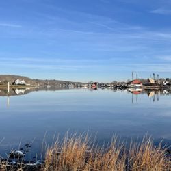
Water rocks and houses The Dr John Champlin Glacier Park is a parcel of land that is owned by the Westerly Land Trust and is open to the public. It's not particularly large, a bit less than 150 acres, but you can stretch out a hike of about 4 or 5 miles if you use all the paths. Nothing strenuous or difficult, all the paths and trails are wide and easy. The Glacier Park is an interesting place if you happen to enjoy geology. As the name implies the area was formed by the glaciers and in fact the entire park is a recessional moraine. Lots of boulders, kettle ponds and other obviously signs of glaciation are present and lots of cool stone walls meander throughout the park. At one time the area held a stone quarry and huge chunks of worked granite can be seen laying around. At the highest point there is an observation platform where you can see a few miles out to the ocean. An impressive and nice view, especially in the winter. One of the biggest problems with hiking here are the houses. The area has been heavily developed recently and houses are visible in the distance during almost the entire hike. They're very nice houses but I would prefer more trees and stones and less signs of humans. Glacier Park isn't a hike for people that like to cover miles and want the solitude of the woods, plenty of other places for that near by. This hike is great for older people, kids or perhaps people with disabilities that keep them from climbing or doing the more difficult hikes. It's also a great place for anyone interested in glaciers or geology. Definitely a place to slow down and look, listen and think. read more


13 years ago
12 years ago
More info about Champlin Glacier Park
Tom Harvey Rd
Westerly, RI 02891
Directions
Hours
Outdoor Amenities
You might also consider


Champlin Glacier Park - hiking - Updated July 2026
Best of Westerly
People found Champlin Glacier Park by searching for…
Things to Do With Kids in Westerly, Rhode Island
Parks in Westerly, Rhode Island
Hiking Trails in Westerly, Rhode Island
Rock Quarry in Westerly, Rhode Island
Scenic View in Westerly, Rhode Island
Walking Trails in Westerly, Rhode Island
Lakes & Ponds in Westerly, Rhode Island
Things to Do at Night in Westerly, Rhode Island
Public Golf Courses in Westerly, Rhode Island
Off Leash Dog Hikes in Westerly, Rhode Island
Parks for Kids in Westerly, Rhode Island
Running Trails in Westerly, Rhode Island
Waterfalls in Westerly, Rhode Island
Public Beaches in Westerly, Rhode Island
Camping Sites in Westerly, Rhode Island
Swimming Holes in Westerly, Rhode Island
Splash Pad in Westerly, Rhode Island
To Do in Westerly, Rhode Island
Nature Walks in Westerly, Rhode Island
Hiking With Kids in Westerly, Rhode Island
Sunrise View in Westerly, Rhode Island
Beautiful Views in Westerly, Rhode Island
Trending Searches in Westerly, RI
4th Of July Fireworks near Champlin Glacier Park
Black Owned Nail Salons near Champlin Glacier Park
Boat Rental near Champlin Glacier Park
Cliff Jumping near Champlin Glacier Park
Day Trips near Champlin Glacier Park
Dog Friendly Trails near Champlin Glacier Park
Fireworks near Champlin Glacier Park
Jet Ski Rental near Champlin Glacier Park
Kayak Rental near Champlin Glacier Park
Lakes & Ponds near Champlin Glacier Park
Off Road Trails near Champlin Glacier Park
Outdoor Activities near Champlin Glacier Park
Parks For Picnics near Champlin Glacier Park
Public Pools near Champlin Glacier Park
Public Shower near Champlin Glacier Park
River Swimming near Champlin Glacier Park
Rock Quarry near Champlin Glacier Park
Scenic Overlook near Champlin Glacier Park
Soccer Store near Champlin Glacier Park
Splash Pad near Champlin Glacier Park
Strawberry Picking near Champlin Glacier Park
Sunrise View near Champlin Glacier Park
Swimming Holes near Champlin Glacier Park
Swimming Lakes near Champlin Glacier Park
Watch Sunset near Champlin Glacier Park
Browse Articles
Browse Nearby
BEST of Westerly, Rhode Island Coffee near Champlin Glacier Park
BEST of Westerly, Rhode Island Restaurants near Champlin Glacier Park
BEST of Westerly, Rhode Island Things to Do near Champlin Glacier Park
BEST of Westerly, Rhode Island Parks near Champlin Glacier Park
BEST of Westerly, Rhode Island Breakfast near Champlin Glacier Park
BEST of Westerly, Rhode Island Beaches near Champlin Glacier Park
BEST of Westerly, Rhode Island Campgrounds near Champlin Glacier Park
Browse Brands
Related Searches in Westerly, RI
Affordable Kayak Rental Services in Westerly, Rhode Island
Best Fishing Locations and Guides in Westerly, Rhode Island
Best Places for Horseback Riding in Westerly, Rhode Island
Best Places for Stunning Views in Westerly, Rhode Island
Best Sledding Spots and Fun in Westerly, Rhode Island
Discover Dog Friendly Trails to Explore in Westerly, Rhode Island
Discover Scenic Bike Paths in Westerly, Rhode Island
Discover Top Boat Tours in Westerly, Rhode Island for All Ages
Discover a Hiking Trail in Westerly, Rhode Island
Discover the Best Night Hike Trails in Westerly, Rhode Island
Dog-Friendly Hikes With Dogs in Westerly, Rhode Island
Enjoy Camping Adventures Around Westerly, Rhode Island
Enjoy Exciting Mountain Biking Adventures in Westerly, Rhode Island
Enjoy Kayaking Adventures in Westerly, Rhode Island
Enjoy River Tubing Adventures in Westerly, Rhode Island
Enjoy Tent Camping Spots Around Westerly, Rhode Island
Enjoy Water Activities and Fun in Westerly, Rhode Island
Enjoy the Best Walking Trails in Westerly, Rhode Island
Exciting Cliff Jumping Spots in Westerly, Rhode Island
Explore Beautiful Parks and Green Spaces in Westerly, Rhode Island
Explore Fun Activities to Do in Westerly, Rhode Island
Explore Popular Campgrounds Near Westerly, Rhode Island
Explore Popular Scenic Overlook Points in Westerly, Rhode Island
Explore Top Dog Parks in Westerly, Rhode Island Near You
Explore the Best Beach Spots in Westerly, Rhode Island
Explore the Best Boating Spots in Westerly, Rhode Island
Explore the Best Swimming Holes Around Westerly, Rhode Island
Family Friendly Hiking With Kids in Westerly, Rhode Island
Find Beautiful Views in Westerly, Rhode Island
Find Cozy Camping Cabins in Westerly, Rhode Island
Find Popular Ziplining Spots Around Westerly, Rhode Island
Find the Best Parks for Picnics in Westerly, Rhode Island
Find the Best Playgrounds to Visit in Westerly, Rhode Island
Find the Best Scenic View Locations in Westerly, Rhode Island
Hiking Trails With Waterfalls in Westerly, Rhode Island
Off Leash Dog Hiking Trails in Westerly, Rhode Island
Plan Nature Center Visits in Westerly, Rhode Island
Plan a Scenic Drive Route Near Westerly, Rhode Island
Popular Fishing Spots to Explore in Westerly, Rhode Island
Popular Outdoor Activities to Try in Westerly, Rhode Island
Popular Picnic Spots to Visit in Westerly, Rhode Island
Popular Things to Do in Westerly, Rhode Island
Safe and Fun Parks for Kids in Westerly, Rhode Island
Top Climbing Spots and Gyms in Westerly, Rhode Island
Top Paddleboarding Activities in Westerly, Rhode Island
Top Places for Snorkeling in Westerly, Rhode Island
Top Running Trails to Explore in Westerly, Rhode Island
Top Swimming Lakes to Enjoy in Westerly, Rhode Island
People who viewed Champlin Glacier Park also viewed
Clay Head Trail
4 reviews
Dr. John Champlin Glacier Park
4 reviews
Barn Island Wildlife Management
3 reviews
Haley Farm State Park
4 reviews
Yawgoo Pond Trail
3 reviews
Mystic River Park Commission
8 reviews
Lantern Hill
3 reviews
East Greenwich Nature Trail
3 reviews
Breakheart Trail
3 reviews
South Kingstown Land Trust Sculpture Park/Trail
2 reviews