Cancel

    Open app

    Search

    Blue Knob State Park

    3.0 (4 reviews)

    Blue Knob State Park Photos

    More like Blue Knob State Park

    Recommended Reviews - Blue Knob State Park

    Your trust is our priority, so businesses can't pay to alter or remove their reviews. Learn more about reviews.
    Yelp app icon
    Browse more easily on the app
    Review Feed Illustration
    Photo of Brad M.
    105
    468
    1435

    11 months ago

    Helpful 1
    Thanks 0
    Love this 1
    Oh no 0

    6 years ago

    Helpful 2
    Thanks 0
    Love this 0
    Oh no 0

    16 years ago

    Helpful 1
    Thanks 0
    Love this 0
    Oh no 0

    8 years ago

    Helpful 0
    Thanks 0
    Love this 0
    Oh no 0

    Verify this business for free

    People searched for Hiking 299 times last month within 15 miles of this business.

    Verify this business

    6 to 10 Trail

    6 to 10 Trail

    4.5(2 reviews)
    11.9 mi

    The Allegheny Portage Railroad National Historic Site is not only a collection of industrial…read moreartifacts, it's also got a great hiking trail, the 6 to 10 Trail System. The 6 to 10 Trail System is the only way you can see many of the attractions here. But for serious hikers, it's also a great trail for just plain ol' hiking. In fact, the NPS website encourages use of the trail, stating that not only is it good for your health, but also for the health of the national parks. The 6 to 10 Trail System is so named because it connects Engine House #6 and the site of Engine House #10. It's not a circular trail, so it's same-way-out/same-way-back walk. Mountain biking is allowed on east end of the trail only, from Muleshoe Bridge to Engine House #10. But before hiking, I warn you--there are some steep slopes along the way and you should have some experienced hikers in your group. In our foursome, the experienced hikers were the females (Susan and Cindy). Rick and Bob, not so much--but in all fairness to my guy, he's quite the cyclist. Comfortable clothing and sturdy hiking shoes are a must. 
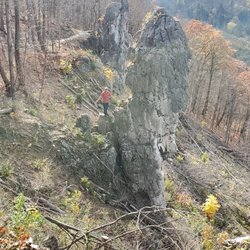
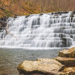
The 6 to 10 Trail Systems follows the route of the old railroad, but it's not really a rails-to-trails. Not all sections are on the roadbed of the old railway. The construction of a portion of "New" US #22 saw to that! We began our hike upon leaving the Lemon House. We proceeded eastward, coming up on the site of Incline #6, a portion of which has been reconstructed. From Incline #6, we go down the slope and pass under the westbound lanes of "Old" US 22. The next site we encountered was the Skew Arch Bridge. With the construction of the highway, it is actually located between the eastbound and westbound lanes. The bridge can be reached via the trail or the mowed incline. After the bridge, the trail briefly curves to the west before heading east again. There aren't many sites to see on this portion of the trail, but it is a beautiful hike in through here. The trail hugs the park boundary along here before curving to the north again. Ah, here begins the fun part of the trail. The slopes get really steep in through here and they'll test your hiking abilities. But hey, Cindy and I are veterans and if we can tackle the Firelane Trail and the Lower Riverview Trails in Frick Park, we can handle this. "C'mon boys, ya gotta keep up with us! We've barely begun the hike!" I shouldn't talk--I know I'm gonna have to test my sugars soon. 
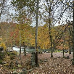
We then pass an historic culvert and then come upon the ruins of Engine House #6 and Incline #6. The next site we saw was Muleshoe Bridge. This is a stone arch bridge over "Old" US 22 and is presently closed to hikers and cyclists. This was also built on the Alegheny Portage Railroad right of way, but is much newer. The Pennsylvania Railroad built a freight train bypass line here in 1904 and it remained in use until 1981. The Pennsylvania called it the New Portage Line and a portion of "New" US 22 was built on that too. There is a tunnel up in Gallitzin called New Portage Tunnel and it remains in use by freight and Amtrak trains today. New Portage Tunnel is the sole remaining railroad operating part of the New Portage Line. But back to the Muleshoe Bridge, here is where the bike trail begins. 
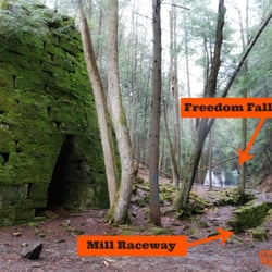
We then passed some more historic culverts and a shout out to my Yelp friend Mike O--no these aren't the "Culverts" where you can get yummy frozen custard. We also passed the Hollidaysburg Reservoir. The State Gamelands are located along here. During hunting season, it is recommended that you wear bright clothing, even though hunting is not allowed on the trail itself. Further east of here, the bike trail splits from the hiking trail. If you're on foot, you will want to remain on the hiking trail. The trail passes the site of Incline #9, although nothing remains. It's mostly a pleasant hike from here and about a mile from the trailhead, the hiking and biking trails rejoin. The Foot of Ten Trail veers off to the left just east of Historic Culvert #1692 and goes to the Engine House #10 ruins at Foot of Ten. The ruins was the end of the line for us too and we decided to take a snack and water break before heading back. Remember, there are no restroom facilities anywhere on the trail. There are no places anywhere on the trail or in the park to obtain food and beverage. Make sure you have an adequate supply before setting out. There are no trashcans along the trail. This is because the park doesn't want furry little creatures scavenging through them. So whatever you bring in, make sure you take out. Finally this is an out-n-back trail. So hike to your abilites. Remember, if you make it to the end, you're really only 1/2 way done because you have to hike back. Thanks to my husband Rick for help in writing this.

    I am training to hike the grand canyon to the bottom and back in one day next month, so this trail…read moreis good prep for that because by starting at the lemon house, you go down first then up. Parts of the 6 to 10 are much steeper than what I will encounter in Arizona. I only did the hiking portion of the trail, as the rest is just flat. Well marked, with a couple exceptions, as I actually veered off the trail unknowingly once. This trail will test your hiking abilities, and will disappoint few serious hikers.

    Photos
    6 to 10 Trail
    6 to 10 Trail
    6 to 10 Trail

    See all

    Laurel Hill State Park - You can see wood frogs here during the Spring season.

    Laurel Hill State Park

    4.6(14 reviews)
    38.7 mi

    As if there wasn't enough parks in the Laurel Highlands, there is Laurel Hill State Park a 3,935…read moreacre natural area of beautiful forest, overlooks, ponds and streams. My recent visit was promising at first, but the rain just kept coming all day long and it "dampened" my spirits completely. I stopped by the main office and got directions to the Jones Mill Dam. Since it was raining so much I gave it some time to clear up, but to no avail. This park is certainly worth checking out and it will be super beautiful later on in the Spring. The wood frogs, spring peepers and other animals will be active. On the same road that this park lies on is two other parks: Kooser State Park and Laurel Ridge State Park, so it is possible to hit those up while in the area. I will certainly make the trip out here later on towards May.

    I was staying at Hidden Valley recently and I was looking for a cool place to hike in the area that…read moreI hadn't been to before and I happen to discover this gem. What a great spot for a hike, but an even better place for a swim, relaxing, a picnic on the grass or some sun on the sand by the water. So after we arrived we hit the trail that ran along the water while taking in the small but beautiful lake. We then proceeded to head into the woods. It was a great little hike and the trails were very easy. After we were done hiking we got the huge blanket and the cooler with snacks and drinks in it out of the car and headed over to a shaded spot under the trees. We sat in the grass area in the left corner of the parking lot and listened to music, ate, drank and enjoyed each other's company for a good while. Then after that we packed up our stuff in the car and headed down to the water and enjoyed the lake which is very clean and refreshing and the scenery is absolutely beautiful. I love that they have sand and everyone looked so happy. They also have an area where you can purchase food and beverages but they also have many other great amenities which I am sure can be discovered on here or on their website. I am so glad I discovered this place. I will most definitely be stopping by again when I am in the area. Enjoy :)

    Photos
    Laurel Hill State Park - A wood frog in their vernal pool near the stream.

    A wood frog in their vernal pool near the stream.

    Laurel Hill State Park
    Laurel Hill State Park

    See all

    Dead Man's Hollow - The first early signs of Spring!  It looks like it will be a good one.  Beautiful crocus flower near the catfish pond area.

    Dead Man's Hollow

    4.1(9 reviews)
    66.9 mi

    This lovely conservation area is 450 acres of beautiful forest with lots to see and a very shadowy…read morepast. The ruins of an old pipe factory are very visible and there are informative signs that tell the story. These occurrences took place in the 1800's. There is history of criminals murdered, accidental death(pipe factory), a hanging, an explosion, a drowning, a giant snake sighting, all taking place in the park. For this reason many people think that the sight is haunted by the people who met their fate here. I hate to burst the excitement, but I have never experienced ghosts, or any other paranormal activity while spending time there. In fact, despite it's dark past Dead Man's Hollow is a very tranquil place. If you have been there during May when Spring season really kicks off you will see tons of wildflowers that are spectacular. The pipe factory had a fire and the ground was burned. This happens to be very good for re-growth and as a result we get to experience a lot of beautiful flora. Also, the old pipe factory remains are covered with cool graffiti. The trails are at times narrow, but they are very clean. You are at some point going to climb up and down hills, so it is a very good workout. I would say that the hiking is a bit more challenging. To find it I would suggest searching via a trailhead name and not just the park name. One example would be "cat fish pond trail." There is a nice parking area near that trailhead. There is also another parking area on the other side of the park(more on that later). This other side is closer to the ruins.

    We checked out the catfish pond today. It looked promising at first but soon discovered that there…read moreis very little accessibility to fish there. The spots that are open are at an incline sloped towards the pond and are very slippery and hazardous. I do not recommend taking young kids there. My daughter and I fished for an hour or so and only saw bluegill in the 3-4" range and smaller minnows. We used lures and worms and had many bites but the fish were too small to get hooked. We did see many water turtles and even a few babies whose shell was about 2-3" in diameter. We also saw one large snapping turtle appear for a few seconds. There are also a bunch of bullfrog minnows whose bodies were the size of golf balls (early June). It's a cool place to see but we won't be returning to fish.

    Photos
    Dead Man's Hollow - Beautiful crocus flowers near the catfish pond area.

    Beautiful crocus flowers near the catfish pond area.

    Dead Man's Hollow - The "cloth of gold" crocus flower.

    The "cloth of gold" crocus flower.

    Dead Man's Hollow - Just two dudes hiking the trail.

    See all

    Just two dudes hiking the trail.

    Laurel Highlands Hiking Trail - Rte. 271 trailhead during 2017 LHHT Ultra marathon.

    Laurel Highlands Hiking Trail

    4.7(3 reviews)
    23.4 mi

    I spent 3.5 days and 3 nights on this trail this past memorial day weekend, my first venture back…read moreinto the backpacking world. This trail begins in Ohiopyle or Johnstown and ends whichever way you choose. If I were to try to pack the entire length I would start at the North end in Johnstown and hike South, to ease up the ankle pain and knee pain :) That comes with packing 20lbs + pack weight and hiking 18-19 miles in one day. Throw in the elevation gain and you will see what I mean. I hiked the South end starting in Ohiopyle and going out to about 26 miles over my time there, then I turned around and came back over two days. Things to note for overnight campers: You can call ranger station at trailhead to make your camping reservation, by credit card it is 4$ a night. Water: there is non drinking water at each campsite, bring a water filter or boil that water as it is not tested. I filtered stream water the whole time and it was fine. Ohiopyle about 6 miles in has the nicest camping ground with access to a large stream, but not all the sites have that. You might want to filter water for night hiking into camp. To save hiking a mile extra back out to get some as I had to do. Firewood, there are fire pits in the shelters if you want to skip the tent but bring something to lock your food up, mice are common in the shelters. I slept in a tent kept my back in the tent with me. There are portapotty type johns at the campsites. Weather: if you check local forecast plan on temps on the trail and at camp at night being around 10 degrees colder because of the elevation change, and storms. Bring rain gear if you're out for more than a day hike! Now for the trail, it is blazed yellow on the trees hard to get lost but a map would have been nice to have. However no maps available in Ohiopyle you have to pay for one at the Laurel State Park office. I did not do that would rather buy a hiking book with the trail in it at a later time. In most places its wide very rocky, lot of tree roots its murder on the soles of your feet, wear boots or stiff soled shoes if hiking for more than one day. Poles could come in handy, I don't use hiking poles but I got caught in little thunderstorm and had to grab a forest walking stick. Some places it looked like they barely blazed a trail at all it was very narrow hard to hike on. Hike with caution. Beautiful river runs stream runs, skyline views, and rock formations. In the first 26 miles views are at mile 6 ish and 24ish, rocks b between 15-20. Lots of birds, and small wildlife I only saw one deer. There is a shooting range at mile 25, just outside the park you will hear lots of gunshots. I would not recommend taking a break or relax day at the Grindle ridge campground out there as I did. Also the campgrounds that have broken water pumps currently are Grindle Ridge and Route 653 shelters campground. This is a lovely hiking trail but steep, be prepared for a challenge in the beginning. Happy Trails!

    How can you not LOVE the LHHT? Its a trail I've frequented quite often in the last 15 years, and…read morehope to explore the entire 70 miles. This picture was taken during the Laurel Highlands Ultra race in June 2017. This race can be run as a relay or individually. They also sponsor a 50k race, which is approx. 30 of the 70 miles. There are many trail heads and shelter areas. The trail is great for day hikes, as well as multiple overnight stays. There are also many ambitious people who hike the entire thing. Its always fun to pass fellow hikers on the trail. Trail stories are always fun to hear, and there are people from all over that you'll meet. Running the trail is quite a challenge, as there's drastic elevation changes at some points and many technical areas. I suggest if you've never run the trail, and expect to run the race, you must do at least 1-2 runs on the trail.

    Photos
    Laurel Highlands Hiking Trail - Rte. 271 trailhead during LHHT Ultra marathon 2017

    Rte. 271 trailhead during LHHT Ultra marathon 2017

    Laurel Highlands Hiking Trail - Finish for 2017 LHHT Ultra Marathon, Rte. 56, Seward, PA

    Finish for 2017 LHHT Ultra Marathon, Rte. 56, Seward, PA

    Laurel Highlands Hiking Trail

    See all

    Valley Falls State Park

    Valley Falls State Park

    5.0(18 reviews)
    100.9 mi

    Valley Falls State Park. Fairmont, WV. My husband and I visited this scenic West Virginia State…read morePark in Sept, 2025. Its highlight is a series of four cascading WATERFALLS on the Tygart Valley River that are easily accessible by a short path from the parking lot. There are large flat rocks right next to the falls, allowing for scenic photographs but no swimming. (Fishing with license and whitewater kayaking are allowed). Fun Fact: this is one of the sites for West Virginia's "Almost Heaven" swings, installed by the state's Department of Tourism across the state for photo opps. This particular swing has the falls in the background. (As of late 2025, there are 51 swings in the state). We had a unique experience at the park in that we were approached by a park volunteer in an ATV offering us a ride down to the falls, and then continuing along some park paths with his commentary about the history of the site as a 19th-century mill town, and pointing out some gristmills. Both park admission and the ATV ride were free although we did give the volunteer a tip. There are 18 miles of trails for hiking and mountain biking, ranging from easy to difficult. We didn't do any hiking on this visit, but did eat our picnic lunch at one of the conveniently located picnic table. There is a gift shop on-site, as well as clean restrooms. It's also a site on WV's Waterfalls Trail, wherein you can earn prizes for checking it at specific WV waterfalls. Note that this is a day-use park, so no camping is allowed. Wi-Fi connectivity is low to non-existent. We approached the park from the south, near Pruntytown, WV, and while the distance was short (about 12 miles), it took us about 25 minutes to reach because of curvy roads. On our return, we went to Tygart Lake State Park, via Grafton, where we camped for the night.

    Tony and I went for a nice hike today at Valley Falls State Park in Fairmont WV…read more The Park is lovely and the Park is free to enjoy with plenty of picnic tables, restrooms, grills, playground, and the gorgeous waterfalls

    Photos
    Valley Falls State Park
    Valley Falls State Park
    Valley Falls State Park

    See all

    Blue Knob State Park - hiking - Updated May 2026

    Loading...
    Loading...
    Loading...