Bar Island Photos


More like Bar Island
Recommended Reviews - Bar Island
Start your review...

Reviews With Photos

It's cosmic. I just can't describe it any other way- but it felt as if Moses had just separated the ocean and hubs and I literally- in every sense of the word- walked on dry land in 2021! Bar Island sits between the Skillings River and the town of Bar Harbor. We came here almost noon time in late March to get the inside scoop on tide times but were entranced by the scent, blueness of the ocean and dynamic waves and had to come back. We returned later that same day at 5:30ish when tide was low to experience this phenomenon. Because it was off peak season when we came here, we actually parked by a gravel road feet away from this rarity on high tide. Driving on dry land though, was a whole other story. We could've driven another minute or two to the next patch of land, but this was truly new to us and were so speechless, we didn't know what else to expect. But don't take my word for it. It's sublime. It's a miracle.

Wow, Bar Island is definitely an interesting spot to visit while in Bar Harbor. Definitely heed the warning of high tide. The first day we went it was high tide...read the warning that is is only safe to cross the bar 1.5 hours before and after low tide. If one gets stranded due to high tide, will be there for 9 hours before the next low tide. Was nice to watch the water...very calming and peaceful just standing there. The next day went early during low tide around 8:30AM and went across and back within 30-45 mins to take pictures. Nice to cross over to Bar Island and take pictures. Went to have breakfast and came back to watch high tide slowly come in.... You can see the tide coming in faster as the land gets covered with water fast... Best to keep an eye on the time and the water.. Enjoy the dry land crossing over but make sure to get back before you get stuck... calling a water taxi for rescue can cost you plenty...

This spot is wild! One minute you're on Bar Harbor watching folks kayaking in the water between Bar Harbor and Bar Island and the next they're walking across the sandbar to the island thanks to low tide! Pretty neat. Part if Acadia National Park, Bar Island isn't populated and there isn't much on the island beyond a few beautiful hiking trails and some waterfront but it's still so cool. The experience of walking there across the water alone is worth doing. Lots of great nature to enjoy and the water is blue and beautiful (we watched a number of seagulls have a fresh crab lunch as they became exposed in the low tide). Just make sure you pay attention to the timing so you don't get caught at high tide. A townie told me they recently saw a van get taken into the ocean bc they drove over and didn't take the rushing returning tide into account. OOPS. Water taxis are available to scoop you up if you do get caught tho. But you'll have to pay money. The walking experience is free and memorable.


Don't miss the amazing view of the Bar Harbor from the island. It is a small island which is accessible by walk during low tides. I would highly recommend this hike before any moderate-difficult hikes in Acadia. You are walking on pebbles/stones most of the times, so wear shoes accordingly.

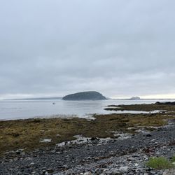
How cool is it to walk to an island? You can do it here and it's pretty amazing. The name on this page is actually incorrect, the name is "Bar Island." It's a tidal island located across from the town of Bar Harbor and is part of Acadia National Park. The island is uninhabited and heavily forested with walking paths for hiking. For about an hour and a half before and after the low tide the island is accessible by foot via a natural gravel land bridge. You can dig in the sand, find shells and seaweed or just pick up a few rocks for souvenirs. Cross all the way to the island and you can hike the trails and take in the spectacular views of Bar Harbor and Mount Desert Island. Make sure you take a watch and keep an eye on the time and the tide schedule or you are may find yourself stuck on the island with twelve feet of water blocking your access back to Bar Harbor. Fear not as you can safely cross again at the next low tide which will be another nine hours or so. It's a good idea to have your cell phone in case you get stuck on the island because you can call a water taxi to pick you up. Phone numbers for water taxi service are posted on signs on the island which state cost is approximately $150 and could take up to an hour. If you are in Bar Harbor do make an effort to visit Bar Island. The experience is definitely worth the minimal effort required and it's free.

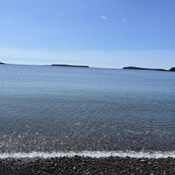
An island that a town was named after. I dislike the star rating system for Yelp and wouldn't even use it if I didn't have to. It's so subjective that it means virtually nothing. Only the verbal description has any meaning. For a place like an island or park or beach there is no service or product; the place just is. You either appreciate it or you don't. Now that the editorial is over I can unequivocally say that this an absolute gorgeous island. It doesn't matter when you go because it takes on a different persona month by month. Ocean, wood, rock and wind makes for an exhilarating combination. You reach the island by going over a half mile long causeway. It tends to be under water a high tide so some care must be taken to manage time. Out of the vast hordes of people visiting Bar Harbor, very few actually make it across the causeway to the actual island that the town was named after. That's too bad because it's an incredible place that is easily accessible. It's part of the Arcadia National Park system and is heaven for hikers or especially sea yakers that enjoy rough, cold conditions. Once on the island you have several options. You can walk the extremely rocky beach that circles the island and be really close to the water and waves the whole time. It's a real ankle breaker so you better have good boots. Only a couple of miles but very slow going and more crawling that actual hiking. Or you can go inland and climb to the summit. A easy hike but one that gives fantastic views of Cadillac Mountain, the town, various boats and cruise ships and other islands in the distance. Or you can hike across the island and visit the swamps, huge boulders and flora that calls the island home. A wonderful place that is impossible to get tired of. The views are always stunning and invigorating and changes from season to season and even day to day. The island has a wonderful personality and is extremely welcoming and friendly. Just make sure you watch the tide.

Despite having done some research in advance, I had not been aware of this particular opportunity. There are many small islands in the region, but this one is notable for having a gravel walkway that sits above the tide for only a few hours a day. An appropriately timed hike yields an array of fantastic views that beggar belief. And this is despite the fact that walking to the end of the trail on the island from downtown, Bar Harbor takes maybe half an hour. Signage warns people not to get trapped on the island when the tide rises as getting a boat is expensive. I could imagine that if the weather is rough one could get into a bit of trouble here, but as long as you're smart about it, this is a fantastic place to visit. read more


Bar Island is a tidal island connected to Bar Harbor by a gravel and sand bar that is exposed at low tide and submerged at high tide. So interesting to be able to cross from Bar Harbor by foot and then hike to the top of the island for a view of historic Bar Harbor. The city of Gouldsboro still maintains jurisdiction over the island based on its 1798 articles of incorporation. Many families have tried to build a bridge to the island from Bar Harbor, however John D. Rockefeller, Jr. purchased the half of the island that has the sandbar which stopped the bridge from being constructed. Today, the island is part of Acadia National Park. If you visit, mind the times for the tides. People have been stranded and apparently cars have been washed away back in the days when they parked on the sandbar. Once high tide comes in, you will need to wait approximately nine hours for low tide or pay a hefty fine for being stranded on Bar Island. A unique experience in Acadia National Park. read more


4 years ago
Bottom Line: Getting to and from Bar Island is fun but the island itself isn't too exciting. I figured the closest I would ever get to walking on water was making the low tide hike across Frenchman Bay to Bar Island. As many other Yelp reviews have noted, pedestrians and four-wheel drivers can cross between Bar Harbor and Bar Island for 90 minutes before and 90 minutes after low tide. I found the US Harbors website to be helpful for checking the tide schedule for both low tide for Bar Island and High Tide at Thunder Hole. To access the Bar Island Trail, head to the intersection of West St. and Bridge St. and then continue on Bridge St. until the pavement turns into the bed of the bay. Note that as of 6/1/2022 the address on Yelp is very wrong. I've submitted a correction but ya never know if they'll accept the update. There isn't any parking on Bridge St. but West St. does have some metered parking. Of course you could easily walk from anywhere in Bar Harbor. During the hike across Frenchman Bay we enjoyed the novelty of having water on both sides of us. It was also fun to see the different varieties of seaweed and to look for sea life that was left behind in the little tidal pools. We saw a few crabs and barnacles. We also checked out some shells. We splashed around in some puddles wearing our hiking shoes but plenty of people make the crossing in sneakers. Its a bit rocky though so I personally would not want to go barefoot. The hike on Bar Island was mostly wooded and then at the end there are supposed to be views of Bar Harbor but it was a very foggy day so all we saw was gray. Lots of gray. Bar Harbor has two out-and-back trials one of which is a spur of the other. Unfortunately there is not a trail that makes a roundtrip around the island. Bar Island is technically part of Acadia National Park so you are supposed to have a park pass but there surely wasn't anyone there checking. Maybe they do random checks of vehicles making the crossing but I really don't know. To hike round trip across the land bridge its only about 1 mile roundtrip. To hike the land bridge and the trail on Bar Island its about 2 miles roundtrip. read more


5 years ago
It's cosmic. I just can't describe it any other way- but it felt as if Moses had just separated the ocean and hubs and I literally- in every sense of the word- walked on dry land in 2021! Bar Island sits between the Skillings River and the town of Bar Harbor. We came here almost noon time in late March to get the inside scoop on tide times but were entranced by the scent, blueness of the ocean and dynamic waves and had to come back. We returned later that same day at 5:30ish when tide was low to experience this phenomenon. Because it was off peak season when we came here, we actually parked by a gravel road feet away from this rarity on high tide. Driving on dry land though, was a whole other story. We could've driven another minute or two to the next patch of land, but this was truly new to us and were so speechless, we didn't know what else to expect. But don't take my word for it. It's sublime. It's a miracle. read more


 - Parks Near Me")


Wow, Bar Island is definitely an interesting spot to visit while in Bar Harbor. Definitely heed the warning of high tide. The first day we went it was high tide...read the warning that is is only safe to cross the bar 1.5 hours before and after low tide. If one gets stranded due to high tide, will be there for 9 hours before the next low tide. Was nice to watch the water...very calming and peaceful just standing there. The next day went early during low tide around 8:30AM and went across and back within 30-45 mins to take pictures. Nice to cross over to Bar Island and take pictures. Went to have breakfast and came back to watch high tide slowly come in.... You can see the tide coming in faster as the land gets covered with water fast... Best to keep an eye on the time and the water.. Enjoy the dry land crossing over but make sure to get back before you get stuck... calling a water taxi for rescue can cost you plenty... read more


8 years ago
This spot is wild! One minute you're on Bar Harbor watching folks kayaking in the water between Bar Harbor and Bar Island and the next they're walking across the sandbar to the island thanks to low tide! Pretty neat. Part if Acadia National Park, Bar Island isn't populated and there isn't much on the island beyond a few beautiful hiking trails and some waterfront but it's still so cool. The experience of walking there across the water alone is worth doing. Lots of great nature to enjoy and the water is blue and beautiful (we watched a number of seagulls have a fresh crab lunch as they became exposed in the low tide). Just make sure you pay attention to the timing so you don't get caught at high tide. A townie told me they recently saw a van get taken into the ocean bc they drove over and didn't take the rushing returning tide into account. OOPS. Water taxis are available to scoop you up if you do get caught tho. But you'll have to pay money. The walking experience is free and memorable. read more


Don't miss the amazing view of the Bar Harbor from the island. It is a small island which is accessible by walk during low tides. I would highly recommend this hike before any moderate-difficult hikes in Acadia. You are walking on pebbles/stones most of the times, so wear shoes accordingly. read more


How cool is it to walk to an island? You can do it here and it's pretty amazing. The name on this page is actually incorrect, the name is "Bar Island." It's a tidal island located across from the town of Bar Harbor and is part of Acadia National Park. The island is uninhabited and heavily forested with walking paths for hiking. For about an hour and a half before and after the low tide the island is accessible by foot via a natural gravel land bridge. You can dig in the sand, find shells and seaweed or just pick up a few rocks for souvenirs. Cross all the way to the island and you can hike the trails and take in the spectacular views of Bar Harbor and Mount Desert Island. Make sure you take a watch and keep an eye on the time and the tide schedule or you are may find yourself stuck on the island with twelve feet of water blocking your access back to Bar Harbor. Fear not as you can safely cross again at the next low tide which will be another nine hours or so. It's a good idea to have your cell phone in case you get stuck on the island because you can call a water taxi to pick you up. Phone numbers for water taxi service are posted on signs on the island which state cost is approximately $150 and could take up to an hour. If you are in Bar Harbor do make an effort to visit Bar Island. The experience is definitely worth the minimal effort required and it's free. read more


17 years ago
An island that a town was named after. I dislike the star rating system for Yelp and wouldn't even use it if I didn't have to. It's so subjective that it means virtually nothing. Only the verbal description has any meaning. For a place like an island or park or beach there is no service or product; the place just is. You either appreciate it or you don't. Now that the editorial is over I can unequivocally say that this an absolute gorgeous island. It doesn't matter when you go because it takes on a different persona month by month. Ocean, wood, rock and wind makes for an exhilarating combination. You reach the island by going over a half mile long causeway. It tends to be under water a high tide so some care must be taken to manage time. Out of the vast hordes of people visiting Bar Harbor, very few actually make it across the causeway to the actual island that the town was named after. That's too bad because it's an incredible place that is easily accessible. It's part of the Arcadia National Park system and is heaven for hikers or especially sea yakers that enjoy rough, cold conditions. Once on the island you have several options. You can walk the extremely rocky beach that circles the island and be really close to the water and waves the whole time. It's a real ankle breaker so you better have good boots. Only a couple of miles but very slow going and more crawling that actual hiking. Or you can go inland and climb to the summit. A easy hike but one that gives fantastic views of Cadillac Mountain, the town, various boats and cruise ships and other islands in the distance. Or you can hike across the island and visit the swamps, huge boulders and flora that calls the island home. A wonderful place that is impossible to get tired of. The views are always stunning and invigorating and changes from season to season and even day to day. The island has a wonderful personality and is extremely welcoming and friendly. Just make sure you watch the tide. read more


I can't believe this park/island/freak of nature only has one other review at this point. This was the coolest thing ever!!!! I am so glad my husband heard about it so we could enjoy it. I could have done this every day of our vacation. This being take the Bar Harbor Island Path to Bar Harbor Island. Huh? You're saying. Yes, you can WALK to the island! For 2 hours after low tide starts till 2 hours before high tide starts, the water is low enough to show land. You can walk to the island. The path that you walk on is rocky, pebbles. It's almost like shoreline, but its it. It's the bottom of the bay. Seagulls are catching crabs, people are paddling kayaks, paddle board lessons are happening, families are strolling, dogs are trotting. Cameras clicking away. It is a hive of activity. You can just walk the path. Or you can do some more "hiking" on the island. We even just spent some time chilling on a large branch checking out the sites. It was a great way to spend a morning. read more


More info about Bar Island
Gouldsboro, ME 04609
Directions
Hours
Outdoor Amenities
Ask the Community - Bar Island
Review Highlights - Bar Island


Bar Island - parks - Updated May 2026
Best of Gouldsboro
People found Bar Island by searching for…
Things to Do in Gouldsboro, ME
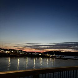
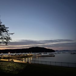
Watch Sunset in Gouldsboro, ME
Hiking Trails in Gouldsboro, ME
Things to Do on a Rainy Day in Gouldsboro, ME
Places to Take Pictures in Gouldsboro, ME
Beautiful Views in Gouldsboro, ME
Swimming Lakes in Gouldsboro, ME
Dog Friendly Trails in Gouldsboro, ME
Scenic Views in Gouldsboro, ME
Picnic Spots in Gouldsboro, ME
Off Road Trails in Gouldsboro, ME
Walking Trails in Gouldsboro, ME
Fishing Spots in Gouldsboro, ME
Browse Nearby
BEST of Gouldsboro, Maine Playgrounds near Bar Island
BEST of Gouldsboro, Maine Things to Do near Bar Island
BEST of Gouldsboro, Maine Coffee near Bar Island
BEST of Gouldsboro, Maine Restaurants near Bar Island
BEST of Gouldsboro, Maine Picnic Areas near Bar Island
BEST of Gouldsboro, Maine Breakfast near Bar Island
BEST of Gouldsboro, Maine Campgrounds near Bar Island